Loading document...
F8 - POYLLVAAISH AND SCARLETT PENINSULA
UNDULATING LOWLAND PLAIN
F8 –POYLLVAAISH AND SCARLETT PENINSULA Key Characteristics Predominantly flat open arable and pastoral land with large rectilinear fields in a rough geometric pattern in close proximity to the coast. Little settlement in the area other than a few scattered farms surrounded by small woodland blocks. Eastern periphery meets and is influenced by the built up areas of Castletown, Ballasalla and the environs of Ronaldsway Airport. Various archaeological sites along the coastal areas including a Viking burial. Coastal views over open land with little intervening substantial tree cover. Some small rectilinear drainage ditches running along field boundaries. Few abandoned limestone quarries now flooded. Isle of Man Steam Railway with various stations cuts across the area east-west. Relative sense of tranquillity amongst the fields and on the Scarlett Peninsula, but reduced near main roads and Poyll and Vaaish quarries. Large country estates west of Malew Road Overall Character Description
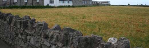
Predominantly flat open arable and pastoral land with large rectilinear fields in a rough geometric pattern spreads across this area in close proximity to the sea with the Scarlet Peninsula projecting out into Bay-ny-Carrickey. Manx hedges containing gorse, hedgerow shrubs and small windswept trees delineate the large fields that contain grazing stock as well as numerous horses. There is relatively little tree cover in the area with the exception of some fragmented woodland on the slightly higher ground around Balladoole House and along the road that runs to Maddrell’s Bridge.
Other than the Silver Burn, whose lush banks marks the area’s eastern boundary, and the vegetated valley of River Colby in the east of the area, there are few substantially sized water courses in the area. Small drainage ditches run along the sides of some fields with various aquatic species growing in them while numerous flooded limestone quarries in the east of the area represent ecologically valuable freshwater bodies.
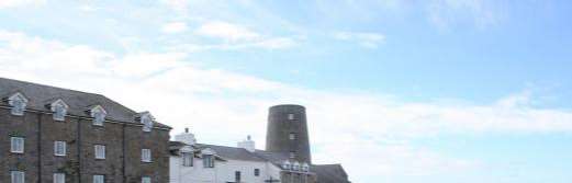
Field boundaries meet the coastal strip with irregular edges that abut the low rocky foreshore as the area’s southern boundary follows the coastal path. The area’s northern boundary follows the A7, after which the land starts to gently rise as it leaves this limestone area with numerous nucleated settlements such as Colby and Ballabeg located on the northern edge of the road. The eastern periphery of the area has a few scattered farmsteads with associated outhouses nestled amongst the fields. The eastern area is also influenced by the built up area of Castletown and Ballasalla, whose grey pebble dashed housing estates form part of the southern boundary around Castle Rushen High School and Maddrell’s Bridge. The numerous straight roads in the area follow the geometric field pattern and are enclosed by Manx hedges and have distinct road markings where they form the route of the Southern 100 Course with numerous viewing platforms and race marshals’ boxes. The Viking burial north of Pooilvaaish is one of the many archaeological sites in the area that include burial mounds and numerous earthworks usually located in prominent positions with sea views. The area has a rural and coastal character with its remoteness impaired slightly by the built-up character of the surrounding areas but with some tranquillity on the Scarlett Peninsula and along the coast.
Key Views
Open and panoramic views out to sea, up to the Southern Upland peaks over open fields and towards the built-up areas of Castletown and Ballasalla are obtained from various slightly elevated positions within the area, where the cumulative effects of hedgerow trees does not intervene.
Foreshortened views in some flatter areas where the accumulated effects of hedgerow trees creates a wooded horizon.
Historic Features
Keeill Vael.
Various Burial Grounds and earth works, most notable being Balladoole Viking Ship Burial. St. Lupus’ Church. Round house. Ecological Features Flooded limestone quarries with aquatic and marginal habitats.
Aquatic and riparian waterside habitats in the numerous small drainage ditches, standing bodies of water as well as along Silver Burn and The Colby River.
Riverside deciduous woodland. Farmland and grassland habitats. Hedgerow matrix containing high biodiversity and habitats. Evaluation of Inherent Landscape Sensitivities Valuable aquatic, riparian and wet meadow habitats alongside Silver Burn river. Numerous archaeological sites. Open coastal views over agricultural land with little substantial woodland. Large rectilinear field pattern close to the coast. Low Manx hedges containing wind swept gorse and sparsely scattered deciduous trees Landscape Strategy
The overall strategy should be to conserve the strong sense of openness throughout the area, with strong field pattern as well as the setting of the numerous archaeological sites within the area.
Copyright in submitted documents remains with their authors. Request removal
View as Markdown