SKY HILL PLANTATION PLANNING STATEMENT FOR ERECTION OF NEW CLUBHOUSE FACILITY
1.0 The site
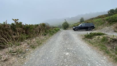
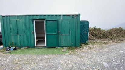
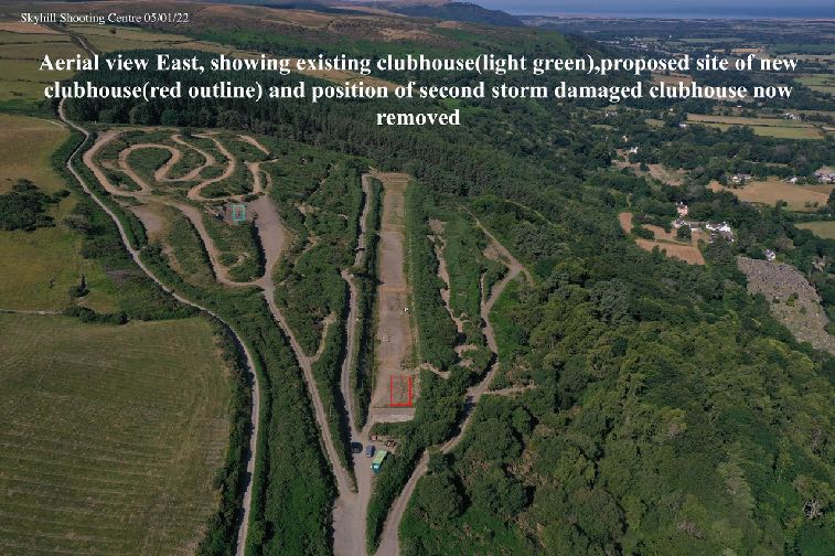
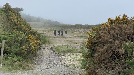
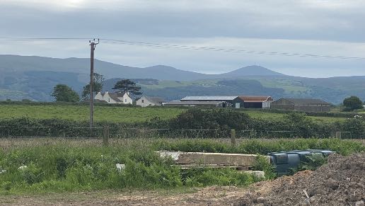
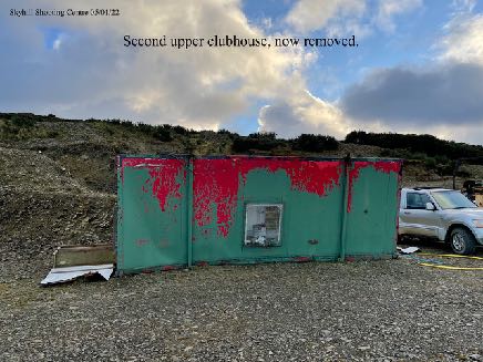
1.1 The site is part of Sky Hill plantation which lies to the west of Ramsey. The site of the proposed works is an area which includes the site of a container currently used as a clubhouse, and portable toilet and these sit opposite a cleared area which provides car parking and alongside, and also included within the site, is a shooting range which has planning approval (see later) within which there was formerly a clubhouse structure which are all shown blow:
Current parking area and access Current clubhouse and toilet facility understood to have been in situ for at least 7 years
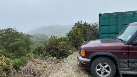
A photograph showing a gravel access track leading up a misty, rural hillside with a black SUV parked on the right.A photograph showing a green shipping container structure situated on a gravel and grass verge, likely representing the proposed storage or clubhouse facility.Annotated aerial photograph showing a shooting range site with overlays indicating the existing clubhouse, proposed new clubhouse site, and removed structure.
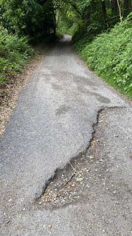
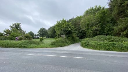
1.2 Access to this higher level of the plantation is via a largely single track lane from the A3 and which winds between the trees, upward with a small number of passing places. This lane is a public footpath and part of the Millennium Way.
1.3 The condition of the lane is not consistent or particularly good and vehicles without reasonable ground clearance may encounter difficulties with some of the drainage channels.
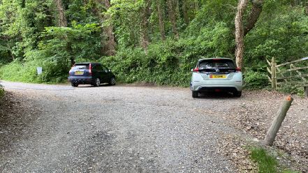
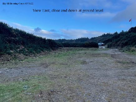
1.4 Currently there are no formal parking facilities serving the plantations: parking occurs informally alongside the access lane which is single vehicle width in addition to the spaces near the shooting range higher up (see above). There are no marked out spaces and those using the plantation for walking park on the lower parts of the access track where there are drainage channels and generally uneven ground. As well as a small area near the entrance which accommodates up to 3-4 vehicles, there is a second area around 60m further up the track where the track widens slightly to negotiate the corner where a small number of vehicles may also park.
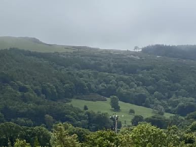
1.5 The site is visible from the north - eg Jurby Road which is 1.5km away and further north albeit that the existing structure is a very small part of the overall much larger landscape and presently difficult to see clearly.
A narrow paved path or lane running through a dense wooded area, showing significant surface cracking and damage in the foreground.A photograph showing a rural outdoor site with a gravel track leading to a cleared area where people are standing near wooden posts.A photograph showing a maroon SUV parked on a dirt track next to a large green shipping container in a misty rural setting.A photograph showing a gravel parking area with two cars parked in front of a dense wooded area.A photograph showing a rural road junction with a path leading into a grassy field surrounded by trees and hedgerows.
2.0 Planning status Land use designation
2.1 The site lies within an area designated on the Isle of Man Planning Scheme (Development Plan) Order 1982 as not for a particular purpose and of an area of High Landscape or Coastal Value and Scenic Significance and appears to be outside of the Woodland Areas on this plan. This is the most up to date land use development plan for this site. There are no Registered Trees or Registered Buildings within the site and the site does not lie within a Conservation Area and whilst there are areas within the firing range, on the national flood risk maps, marked as being at risk of surface water flooding, these areas do not extend as far as any of the existing or proposed buildings on the site which sit higher than these at risk areas.
2.2 There is currently a consultation exercise regarding a new area plan which will cover the north of the Island including this site. The current state of play of this exercise is that following a Call for Sites, Cabinet Office has published a consultation document for a period between 16th April, 2021 and 25th June, 2021 which sets out their preliminary proposals for the north. The plan period relates to 2011-2026 and if and when adopted will supersede the Isle of Man Planning Scheme (Development Plan) Order 1982 as far as it applies to this site. It states that any requirement for housing and employment land for the north will be focused on land at the edge of and within Ramsey as being sustainable urban extensions in line with the Strategic Plan settlement hierarchy identifying it as a Service Centre, the highest level of settlement in the north. It states that whilst development will be directed towards Ramsey, development in the service villages and villages is “not ruled out” but is likely to be low key especially given the level of housing opportunities that need to be found up to 2026.
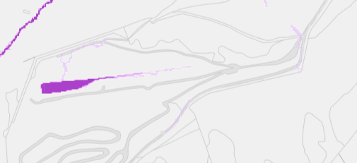
A landscape photograph showing a rural setting with rolling hills in the background and a row of white buildings and agricultural structures in the mid-ground.A photograph showing a rural, hilly landscape with dense woodland and green fields under an overcast sky.A schematic site plan showing a proposed development area highlighted in purple along a road network.
2.3 This Cabinet Office document identifies the importance of the role of informal play areas for children and safe, attractive and accessible green spaces and footpaths for all adults in supporting health and active lifestyle noting the positive health and well-being outcomes, mentally and physically of regular exercise and the resulting reduction in the need for formal health provision (paragraph
3.6.14) and the benefits of active travel.
2.4 The document states that there is a current trend for a declining population and this, together with the amount of housing already provided results in a significant reduction in the amount of new housing that needs to be provided in the north from 770 to 238 up to 2026 and that this amount of housing is already available through approvals which have been granted and which are available. This position will be monitored throughout the plan preparation period, and particularly in the light of the Census which is to be undertaken in 2021.
Strategic Plan
2.5 There is a presumption against development here as set out in General Policy 31 of the Strategic Plan. Environment Policy 12 protects the countryside (which is taken as any land not designated for development). As the site lies within an area of High Landscape of Coastal Value and Scenic Significance on the Isle of Man Planning Scheme (Development Plan) Order 1982 Environment Policy 23 is also relevant which identifies the protection of the character of the landscape as the most important consideration.
2.5 Development is generally directed to existing towns and villages4.
2.6 The Strategic Plan recognises the benefit and value of opportunities for leisure and recreation (Chapter 105).
2.7 Recreation Policy 56 and Transport Policy 67 recognise the importance of the protection of footpaths and the use of access routes by pedestrians as well as other road users.
2.8 Transport Policy 78 requires that development is provided with appropriate car parking and parking standards are set out in Appendix Seven. There are no specific standards for cafes but the standard for “Assembly and leisure” the standard if one space per 15 sq m of gross floor space. Other documents
2.9 The Government website states under “Recreation on hill lands and in plantations” states that “Recreational events of all kinds occur within plantations throughout the year” and that “It is recommended that adults should take about 150 minutes of moderate intensity physical activity over a week, and this can be broken down into any sized chunks of time, small or large, over as many days of the week as you like. Walking is a great form of physical activity that does not require any particular equipment and is a great way to reduce stress.”
2.10 The Landscape Character Assessment undertaken in 2008 has not been formally adopted but has been included in the Area Plans for the South and East and presumably will be absorbed into those for the north and west in due course. Within this study the site falls within the much larger area of the Northern Uplands which centres on Snaefell and extends to the north as far as the A3 TT course with a number of Narrow Upland Glens encroaching into this overall upland area.
2.11 This landscape type is characterised by open and exposed moorland in places with large coniferous plantations and is largely devoid of built structures other than traditional farmhouses and scattered dwellings. It also refers to a “smooth and uninterrupted skyline except for visually
prominent telecommunication towers on top of Snaefell and a tranquil and remote character away from the roads and extensive and panoramic views of surrounding peaks and over the whole Island. The overall strategy for the area is to conserve and enhance the character, quality and distinctiveness of the open and exposed character of the moorland, its uninterrupted skyline and panoramic views, its sense of tranquillity and remoteness and its wealth of cultural heritage features. There is no specific reference to this site.
3.0 The proposal
3.1 Proposed is the replacement of the existing temporary structures on the site which provide storage and toilet facilities for the shooting range as well as a temporary clubhouse, with a new, permanent building providing these facilities.
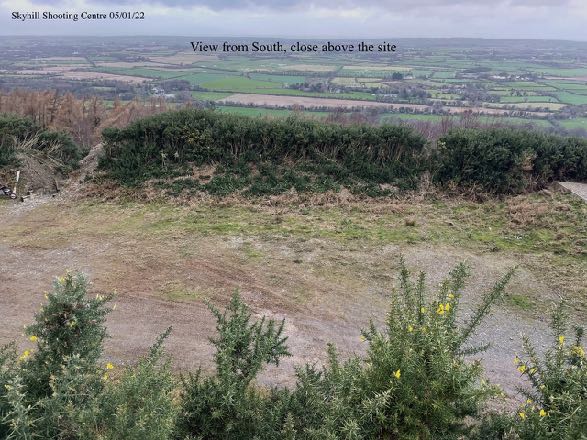
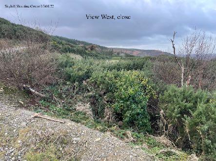
3.2 The area where the new building is to be erected is currently clear of structures, on rough ground with a gorse bank on three sides.
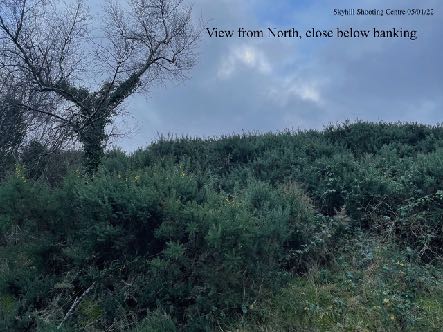
A photograph showing a rural landscape view from the south, looking over fields and hedgerows towards the proposed site location.A photograph showing a grassy, vegetated slope with scrub and trees, labeled as a 'View West, close' from the Skyhill Shooting Centre.A photograph showing a grassy, shrub-covered embankment or hillside with a tree on the left, labeled as a view from the north near a banking.
3.3 The proposed building has a footprint of 10m by 16m with an eaves level of 4.6m and an overall ridge height of 5.6m. The building will be finished in facing brick on the lower half and sheeting above including the pitched roof. The lower 3.4m will be screened by the existing gorse banking as illustrated in the drawings.
3.4 The building will have, on the ground floor, an equipment and supplies store, armoury, reception, cloakroom and toilet which will, due to the ground conditions, be a waterless facility. Above there will be a covered balcony deck, kitchen office and store with the clubhouse room being the largest space (7.8m by 9.8m).
4.0 Planning History
4.1 This part of the plantation has been the subject of a number of applications which are relevant to the current proposal as they demonstrate the lawful use of part the plantation for leisure purposes as well as how proposals for permanent buildings have been considered:
A. 14/00323/B - Re-profiling, maintenance and drainage works to lower part of site to facilitate leisure use of land (retrospective), land Adjacent To Millennium Way - approved subject to conditions regarding grass seeding and one which required further details of drainage which were provided and approved on 20th November, 2014.
B. 13/00358/B - approval granted in May 2013 for the erection of a general storage building with dimensions of 18.4m by 9.1m and an eaves height of around 6m. Conditions 3 and 4 of the approval state:
C 3 - The building hereby approved must be used only for storage and operational purposes associated to the leisure activity use of the adjacent land. C 4 - Outside of the hours of operation of any leisure activity event associated with the adjacent land there must be no external storage of items of equipment and vehicles on the site.
C. 02/02411/A - approval in principle refused in 2003 for demolition of garages and storage buildings and erection of dwelling.
D. 04/00660/B - approval granted at appeal in 2004 for erection of a two storey general purpose storage building to replace existing the appeal was by Lezayre Commissioners against the approval granted on review.
A ground-level photograph showing a grassy clearing or field bordered by trees, likely the site of the proposed shooting range facilities.A photograph showing a weathered green and red prefabricated structure on a gravel site, with text overlay indicating it is a removed clubhouse.
E. 90/00234/B - approval granted to enlarge portion of existing vehicular track to form safe turning area, and improve entrance to field.
F. 89/01701/C - approval granted at review in June 1990 for the change of use of land from agricultural to leisure activities. The conditions attached to the approval are reproduced below. The officer notes that there were no specific conditions controlling the type of leisure activities or limiting the hours of operation. There is correspondence on the file from the enforcement officer suggesting that conditions 2, 3 and 4 may have been breached. However, there is no evidence as to how and if this matter was concluded.
Conditions:
C 1 - Only fencing and gateways of a traditional agricultural style will be allowed to be erection on the site.
C 2 - No other permanent structures of any sort, neither static nor mobile (e.g. portakabin) will be allowed on the site unless approved as the subject of a separate planning application.
C 3 - No private vehicles may be parked within the site, except those operated directionally in association with the business of running the activities undertaken on the site.
C 4 - The land between the Millennium Way and the service track must be roped off alongside the service track and marked as "Out of Bounds", whenever activities occur within the site.
C 5 - There must be warning notices posted along the perimeter of the site whenever activities are occurring within the site. There must be posted prior to the commencement of any activities and removed after cessation thereof. They may not be permanently affixed.
4.2 In addition to this, there is a letter from the then Planning Enforcement Officer dated which states, inter alia that “The land has a use for leisure activities which is apparently quite broad in its meaning. The use of the land for scrambling does not require a further application as it is covered by the leisure use”.
4.3 The inspector considering the appeal for 04/00660/B also notes that “use of the appeal site and the adjacent hillside to the south for leisure activities has been authorised by the planning authority for a period of almost 15 years” and that “the existing structures have been in situ for more than 5 years and are therefore immune from enforcement action”.
4.4 He goes on, “In any case, given the nature and frequency of the leisure activities and the isolation of the site, a permanent building providing secure storage, toilets and facilities for changing/ showering is a reasonable requirement. Therefore, irrespective of the unauthorised status of the existing structures, in my opinion there would have to be very convincing reasons for withholding planning permission for their replacement with a permanent building”. He was satisfied that provided that the building is set into the hillside it would be screened all year round by the intervening woodland from the A3, Churchtown and other potential viewpoints to the north and that the landform shields the site from the Millennium Way to the north.
5.0 Conclusion
5.1 There are many policies in the draft Area Plan for the North and the Strategic Plan and other documents which recognise the benefit of leisure. This site has planning approval for recreational use (14/00323/B) and previously a building has had planning approval albeit in a different position to that now proposed (13/00358/B).
5.2 The comments by the inspector who was considering 04/00660/B about the need to provide permanent facilities for those using the area refer to this part of the plantation and establish a principle of sorts that if such provision can be achieved without creating an unacceptable visual impact, that this can be acceptable.
5.3 The size, design and position of the proposed replacement building has been sensitively considered given its elevated position and it is considered appropriate to the rural location and mostly screened from view from the north. Its impact on the footpath should be beneficial as it is replacing a number of unsightly structures.
5.4 Parking provision and the level of traffic generated by the site will not change nor will the demand for parking change as a result of the proposed new building. Whilst many clubhouses accommodate alternative uses to help provide income for the provider, such as nurseries, for functions etc, given the remoteness of this site and particularly the inaccessibility for some vehicles, these additional uses are not envisaged and a condition requiring that the building is used only in association with the adjacent shooting range, would be acceptable. The applicant already arranges transportation for those unable to access the range including packages with existing hospitality operators which provide lunch and an experience of shooting is provided at this site.
5.5 As can be seen from the photographs, there are no trees near to the site of the proposed building. Given the sparse nature of the area, it is not proposed to introduce additional landscaping which may look out of place in this context although the applicant would do this if it is felt appropriate.
5.6 In summary, we believe that this application will improve the facilities available for those using the site and at the same time will improve the appearance of the area through the removal of existing buildings of poor form which are more visible to those passing the site on the footpath network in accordance with Environment Policy 1 and those policies which protect the countryside. There will be no change to the level of use of the site or traffic coming to and going from the site. The application proposes similar facilities albeit in a smaller, lower building, which were proposed and approved in earlier applications since when there has been no change in policy or circumstances which would warrant a different position.
1 General Policy 3: Development will not be permitted outside of those areas which are zoned for development on the appropriate Area Plan with the exception of:
(a) essential housing for agricultural workers who have to live close to their place of work; (Housing Policies 7, 8, 9 and 10);
(b) conversion of redundant rural buildings which are of architectural, historic, or social value and interest; (Housing Policy 11);
(c) previously developed land(1) which contains a significant amount of building; where the continued use is redundant; where redevelopment would reduce the impact of the current situation on the landscape or the wider environment; and where the development proposed would result in improvements to the landscape or wider environment;
(d) the replacement of existing rural dwellings; (Housing Policies 12, 13 and 14);
(e) location-dependent development in connection with the working of minerals or the provision of necessary services;
(f) building and engineering operations which are essential for the conduct of agriculture or forestry;
(g) development recognised to be of overriding national need in land use planning terms and for which there is no reasonable and acceptable alternative; and
(h) buildings or works required for interpretation of the countryside, its wildlife or heritage.
2 Environment Policy 1: The countryside and its ecology will be protected for its own sake. For the purposes of this policy, the countryside comprises all land which is outside the settlements defined in Appendix 3 at A.3.6 or which is not designated for future development on an Area Plan. Development which would adversely affect the countryside will not be permitted unless there is an over-riding national need in land use planning terms which outweighs the requirement to protect these areas and for which there is no reasonable and acceptable alternative.
3 Environment Policy 2: The present system of landscape classification of Areas of High Landscape or Coastal Value and Scenic Significance (AHLV’s) as shown on the 1982 Development Plan and subsequent Local and Area Plans will be used as a basis for development control until such time as it is superseded by a landscape classification which will introduce different categories of landscape and policies and guidance for control therein. Within these areas the protection of the character of the landscape will be the most important consideration unless it can be shown that:
(a) the development would not harm the character and quality of the landscape; or
(b) the location for the development is essential.
4 Spatial Policy 5: New development will be located within the defined settlements. Development will only be permitted in the countryside in accordance with General Policy 3.
5 10.1 Introduction 10.1.1 The quality of life on the Island and the quality of our environment are improved by attractive open space and by facilities for recreation and other community purposes. This chapter sets out policies which combine to form a land-use planning framework for the provision, protection and enhancement of such space and facilities.
10.3 Open Space 10.3.1 The presence and use of various forms of Open Space in towns and villages on the Island form an integral part of the fabric of community life. Open Space takes various forms and serves many purposes. It ranges from formally laid parks to the wide and extensive public footpath network including Raad Ny Foillan and Millennium Way.
10.3.2 Open Space forms part of our heritage as well as being an attractive and usable asset, and, in the wider context, provides visual and spiritual relief from the developed urban settlements on the Island. In addition, it provides recreational enjoyment in respect of various active and some less active forms of sporting activity. Open Spaces also provide a means of improving the health and fitness of the Island’s population. Open Space is defined in this context as land used for recreational purposes, both formal and informal, including amenity space whether privately or publicly owned.
6 Recreation Policy 5: Area Plans will identify areas where improvements to informal access to the countryside can be made and to the public footpath network. Existing public rights of way should be retained and any development which affects these will be permitted only if it provides diversions which are no less direct or attractive than existing routes.
7 Transport Policy 6: In the design of new development and transport facilities the needs of pedestrians will be given similar weight to the needs of other road users.
8 Transport Policy 7: The Department will require that in all new development, parking provision must be in accordance with the Department’s current standards.
Copyright in submitted documents remains with their authors. Request removal