Planning Statement For The Conversion Of Existing Wwii Wireless Radio Station To Dwelling, Field 435110, Phildraw Road, Ballasalla, Malew Im9 3Eh
1.0 Introduction
1.1 The site is a field which lies on the western side of Phildraw Road which links the Ballamodha Straight/Foxdale Road (A3) with Ballasalla.
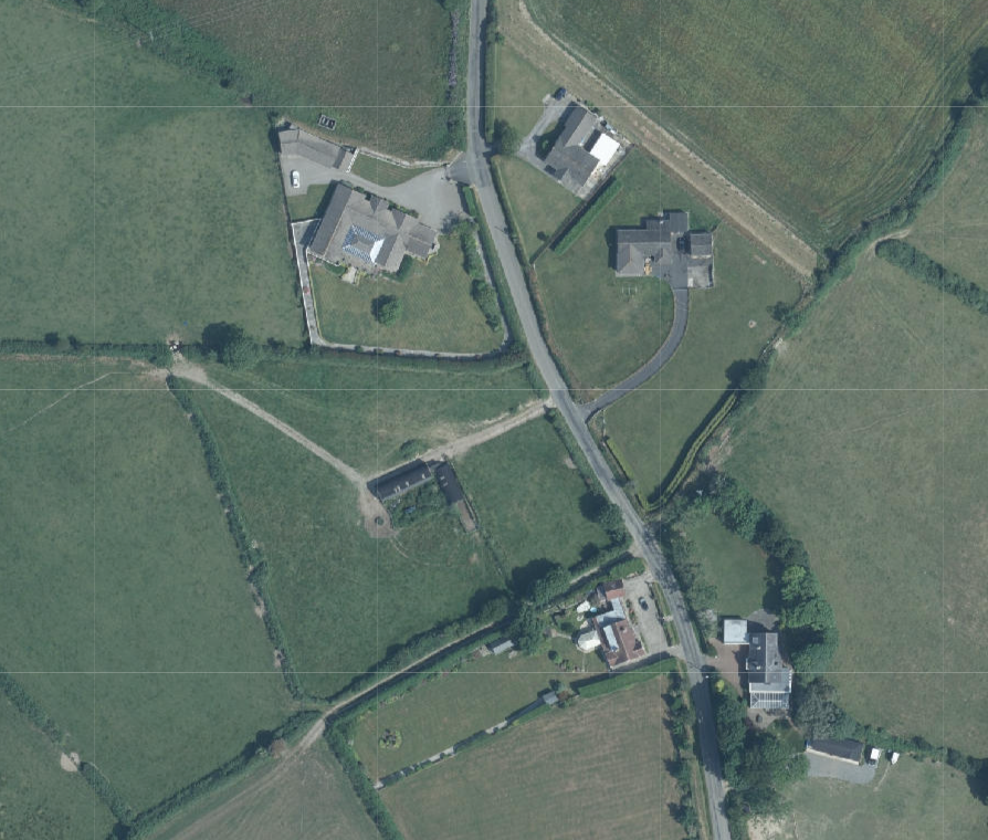
1.2 The site has dwellings to its north and south and on the other side of the road as may be seen below:
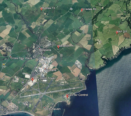
1.3 In the centre of the site is a cluster of buildings which date back to the Second World War where the buildings were used as a Wireless Station. The wireless system for the Island relied upon a series of stations: in the south were the transmitting station at Orrisdale and the receiving station built on the application site. Sources suggest that whilst the Royal Navy may have removed their equipment when HMS Urley at Ronaldsway closed in 1945 the
Aerial site location map showing a rural property with existing buildings, driveways, and surrounding agricultural fields.
sites were back in use by civil Air Traffic Control in 1947. “A Plessey 122R Radio Direction Finder was installed in the control tower. To contradict the chart information an article entitled ' Telecommunications at Ronaldsway' published in the 1980s states that the former RN sites at Orrisdale and Phildraw had been brought back into service to 'provide the airport with four VHF Radio Telephony frequencies'. It seems extremely unlikely that Ronaldsway would in fact require four separate frequencies so most likely there were in fact two frequencies, one for Tower and one for Approach, but with duplicated equipment on each frequency.” (http://www.island-images.co.uk/ATC/zRon1940s/z1940s.html)
1.4 The image below, taking from the above document shows the location of these stations at Ronaldsway and to the north in the 1940s:
1.5 The owners advise that in 1944 the wireless station was compulsory purchased from their grandfather by the Government Property Trustees by order of the Admiralty on behalf of his Majesty. In 1948, the Admiralty agreed to sell the land compulsory purchased in 1944 onto the Trustees for Public Service of the Isle of Man. This document was signed by James Callaghan, who later became U.K. prime minister (he was Clerk to Lord High Admiral of the U.K., Great Britain and Ireland) at the time.
1.6 In 1950, the land was transferred to the IOM Airports Board and in 1952, their grandfather bought the land back. At the time, the applicants advise that they were told by their parents that the site was occupied as a dwelling by the Chief Fire Officer and his wife in the 1950s as it accommodated not only the fire station office but accommodation for the officer.
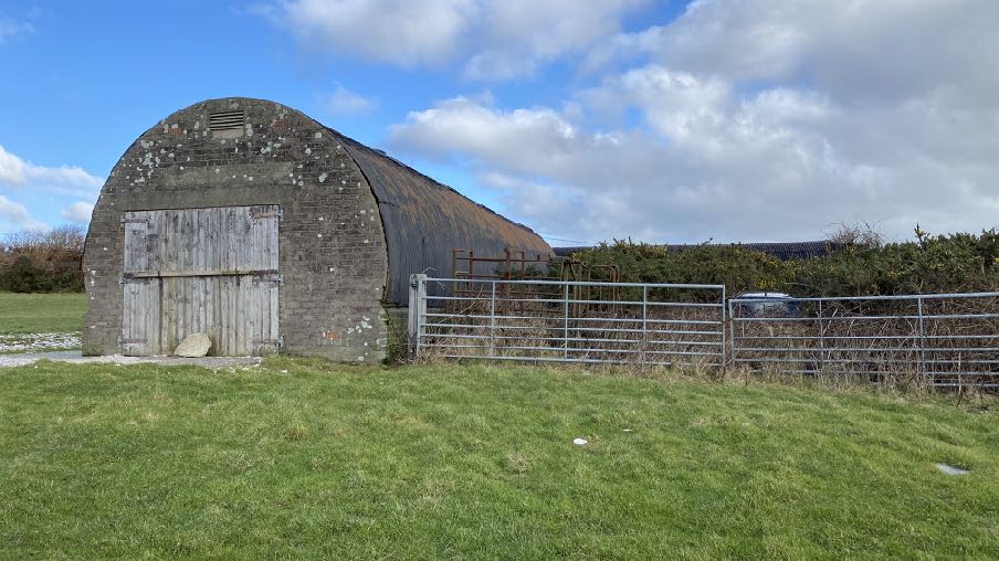
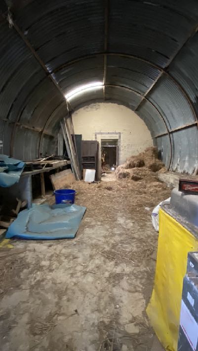
1.7 The buildings remain largely in their original form and have been used for agricultural storage:
Interior photograph of a large agricultural building with a corrugated metal arched roof, containing hay and wooden structures.
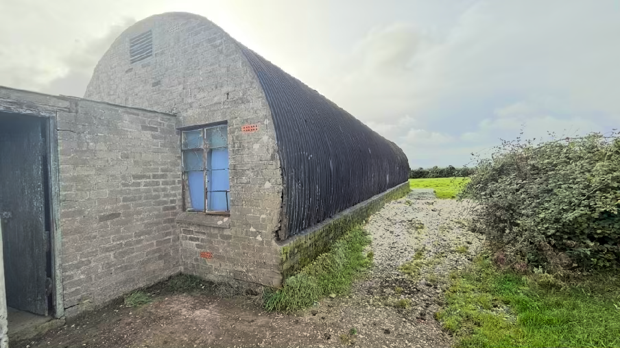
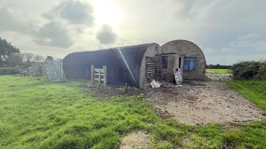
1.8 There are two main structures both with round, sheeted profiles on concrete bases, typical of structures of this type. Similar structures may be found elsewhere on the Island, such as at Ballaquine and Ballaleigh in Michael. One of the buildings has a small brick plinth above which is the cylindrical sheeted roof, the other has no plinth.
A photograph showing a long, curved-roof agricultural building, likely a Nissen hut, with a brick extension attached to the side. The structure is situated on a gravel surface in a rural setting.A photograph of a rural site featuring a long corrugated metal agricultural building attached to a smaller brick structure with a curved roof and a dirt track leading to it.
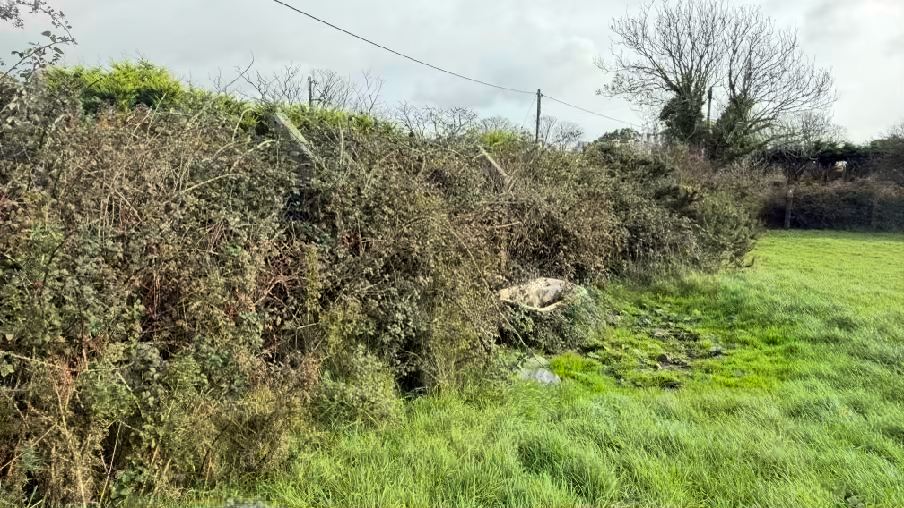
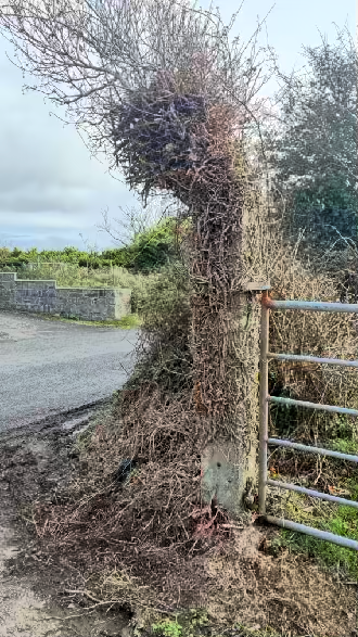
1.9 Access to the site is available in the form of an entrance from Phildraw Road which ispresently gated. Along the roadside within the site is the line of original concrete fence postswhich secured the site:
2.0 Planning policy Area Plan for the South
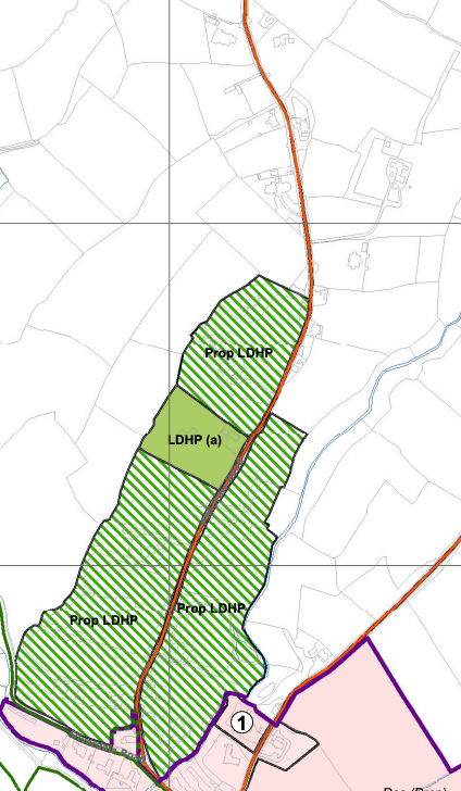
2.1 The site lies within an area not designated for development on the Area Plan for the South which was adopted in 2013. Parts of Phildraw Road have been identified as suitable for Low Density Housing in Parkland - a form of development which allows for high quality housing in the countryside where each dwelling sits in at least one acre of its own grounds.
2.2 This designation stops some way south of the application site (see above).
A planning map displaying land designations and site boundaries with labels such as Prop LDHP and LDHP (a).
2.3 The site is not shown as being subject to any constraints on the appropriate plan accompanying the Area Plan. There are no areas of Registered Trees on or near the site.
2.4 The site is not shown on the national flood risk maps as being at risk of flooding and the site is not within a Conservation Area. None of the buildings on the site is Registered.
Isle of Man Strategic Plan
2.5 The Strategic Plan provides over arching policy guidance which applies across the Island. Ecology is protected under Environment Policies 4 and 7. Applications for conversion of existing buildings to another use or for works to outbuildings where they may be breeding or nesting birds or protected species are generally required to be accompanied by a Preliminary Ecological Survey for such species and if any are found, mitigation and protection thereof to demonstrate that the impact on ecology is acceptable.
2.6 There is a general presumption against development in undesignated areas, as set out in General Policy 3 (see Appendix One). Environment Policy 1 presumes against development which would be harmful to the character and appearance of the countryside.
2.7 This site lies within an area on the Landscape Character Assessment of Incised Slopes. The part relating to this Landscape Character Type is set out at Appendix Two. The conclusion is set out in the Area Plan as follows:
The overall strategy is to conserve and enhance the character, quality and distinctiveness of the area, with its wooded valley bottoms, its strong geometric field pattern delineated by Manx hedges, its numerous traditional buildings and its network of small roads and lanes. The strategy should also include the restoration of landscapes disturbed by former mining activities.
Key Views Distant views prevented at times by dense woodland in river valleys and by the cumulative screening effect of hedgerow trees, which tend to create wooded horizons.
Open and panoramic views out to sea from the higher areas on the upper western parts of the area where there are few trees to interrupt views.
2.8 Whilst there is a presumption against development in this area according to General Policy 3, there is provision for the conversion of existing buildings of interest to other uses, subject to a number of criteria. Housing Policy 11 deals with the conversion of such buildings into residential units:
Housing Policy 11: Conversion of existing rural buildings into dwellings may be permitted, but only where:
(a) redundancy for the original use can be established;
(b) the building is substantially intact and structurally capable of renovation;
(c) the building is of architectural, historic, or social interest;
(d) the building is large enough to form a satisfactory dwelling, either as it stands or with modest, subordinate extension which does not affect adversely the character or interest of the building;
(e) residential use would not be incompatible with adjoining established uses or, where appropriate, land-use zonings on the area plan; and
(f) the building is or can be provided with satisfactory services without unreasonable public expenditure.
Such conversion must:
(a) where practicable and desirable, re-establish the original appearance of the building; and
(b) use the same materials as those in the existing building.
Permission will not be given for the rebuilding of ruins or the erection of replacement buildings of similar, or even identical, form. Further extension of converted rural buildings will not usually be permitted, since this would lead to loss or reduction of the original interest and character
2.9 Environment Policy 16 provides guidance on the conversion of such buildings to other uses.
Environment Policy 16: The use of existing rural buildings for new purposes such as tourist, or small-scale industrial/commercial use may be permitted where:
a) it is demonstrated that the building is no longer required for its original purpose and where the building is substantially intact and structurally capable of renovation;
b) the reuse of the building will result in the preservation of fabric which is of historic, architectural, or social interest or is otherwise of visual attraction;
c) it is demonstrated that the building could accommodate the new use without requiring extension or adverse change to appearance or character;
d) there would not be unacceptable implications in terms of traffic generation;
e) conversion does not lead to dispersal of activity on such a scale as to prejudice the vitality and viability of existing town and village services; and
f) the use of existing buildings involves significant levels of redevelopment to accommodate the new use, the benefits secured by the proposal in terms of impact on the environment and the rural economy shall outweigh the continued impact of retaining the existing buildings on site.
Proposals to convert rural buildings to residential accommodation will be considered along with the advice given at Section 8.10 of this document.
2.10 Development should also take account of Climate Change and aim to support the Island’s target of reducing its carbon emissions to net zero by 2050.
2.11 Development which results in the loss of the most productive agricultural land is presumed against (Environment Policy 14). The soil here is Class 3 so not specifically protected from loss in this respect. The site is not used actively for agricultural grazing.
2.12 Finally, development is expected to result in no Biodiversity Net Loss - avoiding any loss of biodiversity and where there is to be such, mitigation which at least results in an equal replacement in quality and value of habitat lost.
3.0 Planning history
3.1 The site has been the subject of previous applications for residential development. 91/00454/A proposed the principle of the erection of a dwelling and was refused. A further application for the same thing was submitted under 97/01697/A and was also refused.
3.2 There have also been refusals for the erection of new houses in the immediate vicinity 93/00792/A, 94/000062/A, 99/01701/B and 06/00300/A for example.
3.3 There are other applications which have proposed the conversion of existing former WWII structures to new uses. 24/91059/B proposed the conversion of an existing building at Ballaleigh Farm in Michael.
3.4 20/01058/B proposed the conversion of a disused bunker at the Generator Set House and Radar Station in Dalby.
3.5 24/00493/B proposed the conversion, alteration and extension of the Chain Home Radar Bunker in Dalby.
3.5 All of these applications for conversion were permitted.
4.0 The Proposal
4.1 Proposed is the conversion of the existing buildings to form a dwelling. The existing buildings will be retained and a further extension added to the west of what exists, to form a court yard. The additional fabric will match the existing section to the east in form, finish and footprint.
4.2 The existing wall and roof structure is to be removed from the existing buildings and reinstated in a new steel frame with a new cladded exterior replicating what currently exists. The existing flat roofed element which links the two existing buildings will be replaced with a new warm roof structure to provide a more useful link between the two existing buildings and and a similar feature added between the western existing building and the proposed new southern extension.
4.3 The south eastern elevation will have new patio doors inserted with flat roofed canopy details atop and an existing opening in the south eastern gable of the smaller building is to be fitted with new patio doors filling the original aperture. Similarly, the south western elevation of the existing building is to have new fenestration introduced of the same style as that proposed in the south eastern elevation.
4.4 Enhanced visibility splays will be provided through the removal or cutting back of existing vegetation which sits within the visibility splay of 2.4m by 90m to the north and 2.4m by 65m to the south.
4.5 The site will utilise the existing septic tank which is shown on the submitted drawings. If necessary this can be replaced.
4.6 A Structural Report from Curtins and dated 15.12.25 accompanies the application. This describes minor and localised cracking with weathering and mortar loss which is consistent with age and exposure. The award walls are describes as being in good condition considering their age and lack of maintenance and are considered capable of supporting the proposed lightweight loading of the proposed cladding although lack of a cavity or insulation will require addressing.
4.7 The sheeting however is considered to be severely deteriorated and unsuitable for reuse as is the roof of the masonry link. The slab on which the buildings sit is considered to be more than suitable to accommodating the proposed domestic loading and the current
foundation arrangement is considered appropriate for the proposed single storey development.
4.8 The report suggests that there is no evidence or likelihood of unexploded ordnances on the site.
5.0 Planning Assessment
5.1 The importance of World War structures to the Island is manifest in the various Registrations which have been implemented: all of the Registered Buildings in Jurby have an historical association with the WWII and as noted above, planning approval has recently been granted for the conversion of three WWII bunkers to residential accommodation, on the basis that the history of these structures complied with the requirement in HP11 for such buildings to have historical interest (or social or architectural).
5.2 Such structures are becoming more rare as they age and those that remain seem to have been preserved due to their private ownership or an acknowledgement by Government of their historic interest. Finding a use for them will ensure their continued existence, particularly if the buildings are not protected through Registration or Conservation Area status.
5.3 In this case the buildings are visible from the highway to those who might look through the existing farm gate. Anyone passing the site and seeing them would immediately recognise them or wonder at their iconic appearance and perhaps research what they might have been.
5.4 The Landscape Character Assessment requires that development states that “The overall strategy is to conserve and enhance the character, quality and distinctiveness of the area, with its wooded valley bottoms, its strong geometric field pattern delineated by Manx hedges, its numerous traditional buildings and its network of small roads and lanes.” There is no mention in the Assessment of the WWII features here or indeed at Dalby or Ballaleigh although those at the Point of Ayre and at Cregneash are referred to.
5.5 Whllst the site is not designated for development, General Policy 3 includes in its list of exceptions, Housing Policy 11 which allows the conversion of existing buildings of interest to residential use. It is therefore appropriate to consider each of the criteria:
5.6 Redundancy
5.6.1 The buildings to be converted have been used to store agricultural items but notrecently or intensively. The field in which the site lies is 0.8 ha in area which is not large
enough to represent a viable holding. It is likely that the site would be used for grazing or perhaps small scale horticulture.
5.6.2 What is proposed will retain much of the existing field and access will remain available to it from the existing gate field entrance. The existing building is limited in height and regularly shaped surfaces which would be suitable for agricultural storage. The buildings’ original function was not agricultural.
5.6.3 The planning policy requires that the building is redundant for its original purpose. In this case the original purpose was a radio transmitting and receiving station. There is no longer a need for such a facility here or even a fire station and indeed it has not been used for these purposes for several decades.
5.6.4 It is considered therefore that the building satisfies criteria a) of HP11.
5.7 Structural condition
5.7.1 The application is accompanied by a Structural Engineer’s Report which demonstrates that the building is not only structurally stable but is capable of the conversion works which are proposed. The report, prepared by Curtins concludes that “the building is structurally suitable for the proposed conversion and will deliver a safe, durable and regulation compliant building that harmonises heritage with modern standards”.
5.8 The building is of architectural, historic, or social interest
5.8.1 The existing buildings have all three elements of interest in our view. The buildings are architecturally distinct in their design, finish and form and are instantly associated with the 1940s Wartime activities. The buildings are historically interesting due to their association with the War and the Island’s involvement in and reaction thereto. Socially, the buildings are interesting too in that they give an insight into what Phildraw Road was like in the 1940s and 50s including not only the wartime activities but also that the building was used as a fire station.
5.9 The building is large enough to form a satisfactory dwelling, either as it stands orwith modest, subordinate extension which does not affect adversely the character orinterest of the building
5.9.1 The proposal retains the existing buildings, replacing fabric in a form which replicates what exists. The additional element will enable the building to form a satisfactory dwelling,
with this section positioned at the rear such that what will be visible from the road will be more or less what currently exists and creating a private and sheltered courtyard in the middle of the buildings.
5.9.2 The conversion adds a formal parking area which is to be enclosed within a new hedge line which will help screen any parked vehicles from public view and maintain the character of the buildings.
5.10 Residential use would not be incompatible with adjoining established uses or, where appropriate, land-use zonings on the area plan
5.10.1 There are existing dwellings on three sides of the site and the character of the area as one proceeds past this site is very much one of dwellings and residential accesses off the road with the mixed style of dwellings visible from the highway.
5.11 The building is or can be provided with satisfactory services without unreasonable public expenditure
5.11.1 The building can be converted with all necessary services provided without any public expense.
5.12 Such conversion must:
(a) where practicable and desirable, re-establish the original appearance of the building; and
(b) use the same materials as those in the existing building.
5.12.1 The proposals will restore the original appearance of the buildings as viewed from the highway with appropriate and necessary new interventions added to create light and outlook for the occupants. For all intents and purposes, certainly from a public perspective the buildings will remain as is. The scheme will provide a reason why the building could and should be renovated - without the conversion it is unlikely that any renovation would be undertaken for such a modest building with limited flexibility for agricultural use.
5.13 Impact on settlements
5.13.1 Whilst residential development is generally directed towards existing settlements (Housing Policy 5), there is provision within Housing Policy 11 for new dwellings to be created within the countryside where the relevant criteria are met. The creation of a single dwelling on this site should not considered to adversely affect the vitality or viability or interest of any nearby settlement. The benefit of rescuing and repurposing these existing
buildings of historic, architectural and social interest outweigh, in our view the presumption against development on non designated sites outwith an established settlement. In this case, the site lies less than 300m from the northern extent of the zone of Low Density Housing in Parkland with the land in between mostly occupied by existing dwellings.
5.14 Compatibility with adjacent land uses
5.14.1 The proposed use is residential within a field which will remain agricultural/open space. There are dwellings on three sides of the site. As such, the proposed residential development is considered compatible with the adjacent land uses.
5.15 Other matters
5.15.1 The site can be served by an existing wastewater treatment plant.
5.15.2 The existing buildings have been visually inspected and do not accommodate any birds, bats or other wildlife. Appropriate surveys and care will be undertaken prior to any works being carried out. It should be noted that in planning terms, there is nothing preventing the existing buildings from being completely demolished although of course, the provisions of the Wildlife Act 1993 must be observed in such works.
5.15.3 The works will not have any adverse impact on biodiversity but will introduce new native planting which will increase habitat whilst preserving the majority of the field as an open, undeveloped agricultural field.
5.15.4 Whilst the proposal will result in a change and possibly an increase in the amount of traffic using the entrance, the proposal involves the lowering of the roadside boundary such that those leaving the site will be able to see significantly further in both directions than they can at present. The existing roadside hedges are quite high but much of this is due to the naturalised brambles growing on top of the sod hedge. It would be possible to clear all of the over growth without the need for any permission and what would remain would be the original hedge. What is proposed would result in just this albeit slightly lower to enable a view over it from anyone within a vehicle.
5.15.5 The scheme will sensitively find a use for these existing buildings, maintaining their general appearance from the highway and continuing the modest height and distinctive shape and character. The scheme will therefore preserve these interesting buildings for posterity, securing a piece of the Island’s history whilst not undermining the policies which
protect the countryside for its own sake, complying with all of the relevant planning policies which are applicable to the conversion of existing rural buildings to other uses.
Sarah Corlett
16.12.25
Appendix One - policies
Strategic Plan
General Policy 3: Development will not be permitted outside of those areas which are zoned for development on the appropriate Area Plan with the exception of:
(a) essential housing for agricultural workers who have to live close to their place of work; (Housing Policies 7, 8, 9 and 10);
(b) conversion of redundant rural buildings which are of architectural, historic, or social value and interest; (Housing Policy 11);
(c) previously developed land(1) which contains a significant amount of building; where the continued use is redundant; where redevelopment would reduce the impact of the current situation on the landscape or the wider environment; and where the development proposed would result in improvements to the landscape or wider environment;
(d) the replacement of existing rural dwellings; (Housing Policies 12, 13 and 14);
(e) location-dependent development in connection with the working of minerals or the provision of necessary services;
(f) building and engineering operations which are essential for the conduct of agriculture or forestry; (g) development recognised to be of overriding national need in land use planning terms and for which there is no reasonable and acceptable alternative; and (h) buildings or works required for interpretation of the countryside, its wildlife or heritage.
Environment Policy 1: The countryside and its ecology will be protected for its own sake. For the purposes of this policy, the countryside comprises all land which is outside the settlements defined in Appendix 3 at A.3.6 or which is not designated for future development on an Area Plan. Development which would adversely affect the countryside will not be permitted unless there is an over-riding national need in land use planning terms which outweighs the requirement to protect these areas and for which there is no reasonable and acceptable alternative.
Environment Policy 16: The use of existing rural buildings for new purposes such as tourist, or small-scale industrial/commercial use may be permitted where:
a) it is demonstrated that the building is no longer required for its original purpose and where the building is substantially intact and structurally capable of renovation;
b) the reuse of the building will result in the preservation of fabric which is of historic, architectural, or social interest or is otherwise of visual attraction;
c) it is demonstrated that the building could accommodate the new use without requiring extension or adverse change to appearance or character;
d) there would not be unacceptable implications in terms of traffic generation;
e) conversion does not lead to dispersal of activity on such a scale as to prejudice the vitality and viability of existing town and village services; and
f) the use of existing buildings involves significant levels of redevelopment to accommodate the new use, the benefits secured by the proposal in terms of impact on the environment and the rural economy shall outweigh the continued impact of retaining the existing buildings on site.
Proposals to convert rural buildings to residential accommodation will be considered along with the advice given at Section 8.10 of this document.
Housing Policy 11: Conversion of existing rural buildings into dwellings may be permitted, but only where:
(a) redundancy for the original use can be established;
(b) the building is substantially intact and structurally capable of renovation;
(c) the building is of architectural, historic, or social interest;
(d) the building is large enough to form a satisfactory dwelling, either as it stands or with modest, subordinate extension which does not affect adversely the character or interest of the building;
(e) residential use would not be incompatible with adjoining established uses or, where appropriate, land-use zonings on the area plan; and
(f) the building is or can be provided with satisfactory services without unreasonable public expenditure.
Such conversion must:
(a) where practicable and desirable, re-establish the original appearance of the building; and
(b) use the same materials as those in the existing building. Permission will not be given for the rebuilding of ruins or the erection of replacement buildings of similar, or even identical, form.
Further extension of converted rural buildings will not usually be permitted, since this would lead to loss or reduction of the original interest and character.
Consideration may be given to proposals which result in a larger dwelling where this involves the replacement of an existing dwelling of poor form with one of more traditional character, or where, by its design or siting, there would be less visual impact.
Appendix Two
Landscape Character Assessment D14 – BALLAMODHA AND ST MARK’S Key Characteristics
• Land slopes down from the southern uplands towards the coast.
• Numerous deeply incised wooded river valleys and glens cut down into the landscape forming ribbons of fragmented woodland.
• National Glens at Silverdale and Colby
• Settled farmland character with some large nucleated settlements along the A7, small villages and a variety of scattered dwellings and farms.
• Smaller predominantly rectangular pastoral fields with Manx hedges topped with gorse on the upland slopes to the north.
• Patches of gorse, bracken and heather in fields on the upper slopes.
• Larger rectilinear pastoral and arable fields with large deciduous trees growing on Manx hedges on the more gently sloping southern slopes.
• Around the various settlements and farms there are smaller rectangular arable and pastoral fields with Manx hedgerows containing numerous trees and some stone walls.
• Network of tracks, small lanes and larger roads enclosed by substantial hedgerows containing deciduous trees all growing on grass covered Manx hedges.
• Numerous small reservoirs and water bodies associated with water courses.
• Some small churches with spires as well as various standing stones and other visible archaeological sites.
• Presence of Manx Milestones.
• Quarries at Turkeyland and at Billown.
Overall Character Description Land slopes steeply down from the southern uplands with small rectangular fields of rough pasture containing patches of gorse and some bracken in places where these upland species have spread out from the low Manx hedges. A variety of predominantly stone hill farms with numerous outhouses surrounded by fragmented woodland, such as Ballaglashan and Glenmoar Farm, are located on these steeper slopes. The tight geometric field pattern on these slopes loosens as the slope angle becomes shallower with larger, predominantly angular but irregularly shaped fields of grazing and agriculture covering the majority of the
flatter southern area. Smaller fields surround the various small clustered settlements. There are also groups of trees surrounding these settlements (e.g. the more traditional village of St. Mark’s with its stone houses, church and conservation area) and also around loosely clustered dwellings such as those along the A34 north of Ballasalla. Located along the busy A7 road are the two larger nucleated settlements of Ballabeg and Colby whose traditional fabric has been added to with numerous modern extensions that back onto small fields with some screening in the form of mature trees in surrounding hedgerows.
Through this gently sloping and undulating landscape cut numerous steep sided deep and heavily vegetated river valleys, including Colby River, Silver Burn and Santon Burn, with numerous smaller tributaries joining their courses along with various rectilinear drainage ditches. These wooded valleys form sinuous fingers of fragmented woodland that cut across and disrupt the field pattern and otherwise gently sloping landform. Colby Glen and Siverdale Glen are designated both as conservation areas and National Glens. These glens were developed during the Victorian times to allow visitors waterside access and a chance to experience these enclosed valleys and their lush riparian vegetation by way of footbridges and paths with handrails to promenade. Many original features remain today.
A network of small tracks, narrow roads and larger A roads traverse the area and are predominantly contained by steep sided grassy banks of the Manx hedgerows that line the roads, with varying hedgerows, some containing trees in places. There is a settled but semirural character. There is a relatively strong sense of tranquillity that pervades much of the area. Wooded horizons are common inmost places, creating an intimate contained and continuous character. The steep sided Glens break what would otherwise be a relatively monotonous landscape to create active and dramatic elements that one can descend down into from the surrounding fields.
Key Views
• Distant views prevented at times by dense woodland in river valleys and by the cumulative screening effect of hedgerow trees, which tend to create wooded horizons.
• Open and panoramic views out to sea from the higher areas on the upper western parts of the area where there are few trees to interrupt views.
Historic Features
• Numerous chapels and churches including Columbus Church and Kirk Santon with Medieval crosses
• Standing stones and some earthworks
• Rushen Abbey (Cistercian) and Monks Bridge
• Silverdale watermill and roundabout
Ecological Features
• Farmland grassland habitats
• Mature network of hedgerows containing deciduous trees in field boundaries
• Aquatic and waterside habitats along river courses
• Dense riparian woodland in Glen bottoms
• Fragmented blocks of deciduous woodland
• Bird sanctuary at junction of A34 and A3
Evaluation of Inherent Landscape Sensitivities
• Mixture of field size and pattern with various hedges containing a variety of vegetation.
• Fragmented woodland in valley bottoms and along National Glens.
• Rivers and reservoirs with aquatic ecosystem with riparian habitats.
• Built up edge of Ballasalla and nucleated settlements of Ballabeg and Colby.
• Scattered traditional farms and hamlets fringed by deciduous woodland.
• Network of tracks, small lanes and larger roads enclosed by substantial hedgerows containing deciduous trees all growing on grass covered Manx hedges.
• Sites of archaeological importance.
• Manx Milestones by roadside.
• Victorian Isle of Man Steam Railway station and halts.
Landscape Strategy The overall strategy for the area should be to conserve and enhance the character, quality and distinctiveness of this farmed landscape with various field patterns defined by different hedges, a scattered settlement pattern of traditional hamlets, farmsteads and nucleated settlements fringed by trees, a varied road network enclosed by grassed Manx hedges and roadside vegetation, and numerous wooded valleys and glens. In addition to the conservation of archaeological sites, measures should also be adopted to conserve and enhance the physical structure and setting of upstanding heritage features such as the Silverdale watermill.
Copyright in submitted documents remains with their authors. Request removal