Planning Statement For Alterations And Extensions, Ballashamrock House, Port Soderick, Braddan
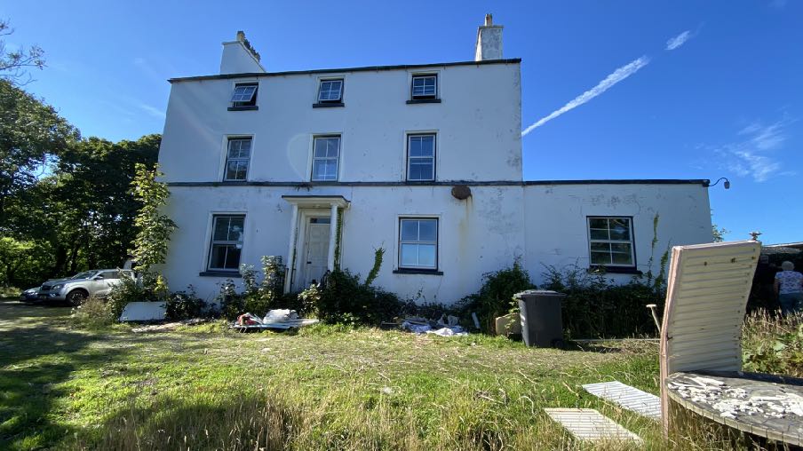
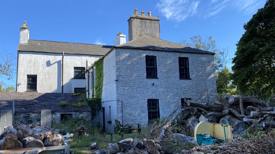
A sunny exterior photograph of a white two-story detached house featuring a single-story extension on the right side, with a grassy garden and parked cars in the foreground.A photograph of a large, white-washed stone dwelling with slate roofs and chimneys, situated in a rural setting with timber piles in the foreground.
1.0 Introduction
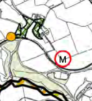
1.1 Ballashamrock Farm sits to the south east of the Port Soderick Glen Road (B23) which links the A25 Old Castletown Road with Marine Drive (A37) and Port Soderick beach and car park.
1.2 Ballashamrock Farm holding is currently farmed in association with Southampton Farm through family connections and both holdings have a range of farm buildings. Ballashamrock Farm accommodates a traditional farmyard which has a number of old stone barns, a larger, more modern shed to the north and three dwellings: Ballashamrock House which sits at the southern edge of the farm group; the old Ballashamrock farmhouse - an additional dwelling which is attached to the rear of Ballashamrock House and the newer farmhouse which sits at the eastern edge of the group and which replaced a former outbuilding (see Planning History). Ballashamrock House is in separate ownership from the rest of the farm and has been for some considerable time (see Planning History).
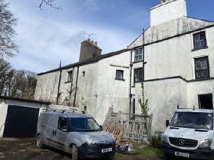
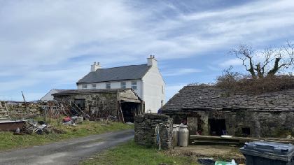
A site location map displaying the rural area around Ballaveare Farm and Ballashamrock Farm, highlighting roads and field boundaries.Exterior photograph of a large, white-washed detached dwelling featuring a garage on the left side with two work vans parked in the foreground.A photograph showing a large white detached dwelling in the background and a lower stone outbuilding in the foreground with construction materials and scaffolding present.
1.3 There are other buildings outside of this group but are not considered relevant to the current proposals.
1.4 Access to the buildings is directly from the A23 up and around a farm lane into the yard which serves all of the buildings cited above. There is an additional route from the access to the south west of the farm buildings and around to the side of Ballashamrock House providing the house with its own, separate access. There is also a track which leads from alongside Ballashamrock House to Marine Drive, passing over the railway line, involving sharp 90 degree corners and skirting the fields.
1.5 The internal layout of the two properties reveals that Ballashamrock House had three floors of accommodation with a lower floor whereas the farmhouse has only two floors. The mutual party wall differs in location per floor with the ground floor of the House extending underneath the upper floor bedrooms of the farmhouse with a resulting flying freehold arrangement for the owners of both properties.
1.6 The owner of Ballashamrock House is currently in the process of renovating the house.
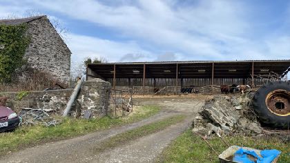
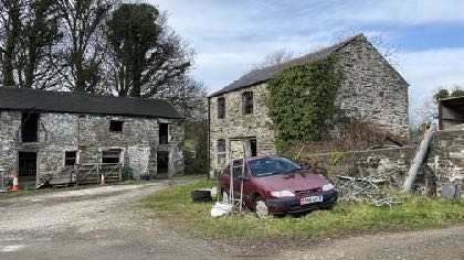
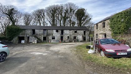
A photograph of a rural site featuring a stone building and a large open-sided agricultural shed with a gravel access track.A photograph of a rural property featuring stone buildings, including a two-story house and a single-story outbuilding, with a red car parked in the foreground.A photograph showing a long stone building, likely a converted barn, with a separate stone structure to the right. There is a gravel driveway with parked cars in the foreground.A photograph showing a white two-story detached house with a slate roof, situated behind older stone outbuildings and a driveway in a rural setting.
2.0 Planning policy
2.1 The site lies within an area not designated for development on the Area Plan for the East which was adopted by Tynwald in 2020 so, a relatively recent development plan. The Area Plan has a number of plans associated with it which highlight various constraints including areas of Registered Trees (more clearly shown below right in red) and a site of archaeological interest/Ancient Monument between the farmyard and Marine Drive:
2.2 This Ancient Monument is not listed as amongst the most notable in the plan area (paragraph 6.12.1) although the Plan has a policy which specifically protects Ancient Monuments as follows:
Urban Environment Proposal 6 Applications on sites or close to sites that contain an Ancient Monument must be designed taking into account the character of the Monument and its environs to ensure it is satisfactorily protected.
2.3 This is similar to Environment Policy 40 of the Strategic Plan:
Environment Policy 40: Development will not be permitted which would damage, disturb or detract from an important archaeological site or an Ancient Monument or the setting thereof.
2.4 Trees are generally protected under Environment Policy 3. There is likely to be a presumption against the loss of any Registered Tree unless this is justified.
2.5 Ecology is protected under Environment Policy 4.
2.6 There is a general presumption against development in undesignated areas, as set out in General Policy 3 of the Strategic Plan (see Appendix One). Environment Policies 1 and 2 presume against development which would be harmful to the character and appearance of the countryside, EP 2 placing even more weight on the protection of the character and quality of the countryside. Environment Policy 2 refers to the areas of high landscape value and scenic significance but these
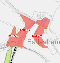
A cropped section of a site location map showing property boundaries, roads, and land use areas.A site plan or location map showing red highlighted zones labeled RA0774, RA0776, and RA0775 adjacent to Soderick Cres.
have been replaced in the Area Plan for the East with the Landscape Character Assessment designations which characterise the countryside by the type of landscape rather than by its perceived quality.
2.7 This site lies within an area on the Landscape Character Assessment as part of the an area of Incised Slopes - D13 - Santon where the railway, field pattern, rural nature, wooded areas and Manx milestones are identified to be protected in the landscape strategy (see Appendix Two).
2.8 The Area Plan has a specific proposal for this area of landscape character:
Landscape Proposal 7 (Santon) In cases where new development is proposed, applications must demonstrate that it can be suitably integrated into the surrounding landscape setting through reasonable mitigation measures and considering siting, colours, materials, finishes and the general scale.
2.9 There is an area of potential risk of surface water flooding running north east to south west between the newer bungalows alongside the A23 and the farmyard on the national flood risk maps. The farmyard and Ballashamrock House are not shown as being at any risk of flooding.
2.10 The buildings on the site are not Registered and the site is not within a Conservation Area. The farm group is on the 1860s County series maps where some of the current buildings appear. On this map, Ballashamrock House is not as large as it appears now as it has no side annex and possibly there was no Ballashamrock farmhouse at this stage and the building at the rear of Ballashamrock House was simply a rear annex - the barn currently running at right angles to the north east of Ballashamrock House is not there and the two storey stone barn to the east of the long two storey barn does not appear.
2.11 At some point between then and the 1930s the farmhouse was created at the rear of
A site location map showing property boundaries and surrounding roads with the text 'Ballashamrock' visible.A close-up section of a site location plan or OS map extract showing property boundaries, a road, and building footprints with elevation markers.
Ballashamrock House and Ballashamrock House was extended to the north east. No planning approvals appear to have been sought or granted for these although it is shown as a separate dwelling on a number of applications submitted after 1953 (see Planning History below).
2.12 Whilst there is a presumption against development in this area according to General Policy 3, there is provision for extensions of existing rural properties (Housing Policies 15 and 16) and also for the replacement of some rural dwellings (Housing Policies 12 and 14).
2.13 Ballashamrock House appears in John Kitto’s book “Historic Homes of the Isle of Man” (1990)
where it is referred to along with Crogga House where it states the following:
“The adjacent estates of Crogga and Ballashamrock House were both owned for something like a hundred years by the well known Quayle family of Castletown. In the eighteenth century when the Manx contraband trade was at its peak and smuggling was no offence under Manx law, both houses were used openly as convenient places to store ‘trade’ goods, for Port Soderick was a favourite landing place. In 1736, the British Customs Protection Act resulted in the increase of revenue cutters patrolling the Manx coast and made landing more difficult and in 1765 the British Government compelled the Duke of Atholl to surrender his Lordship of Mann to the Crown for £70,000 - a compulsory deal which both he and the Manx people resented - and the contraband trade was made illegal in this Island as well as in England. It still continued, as most of the leading Manx families were deeply involved in it and getting considerable profit from it - including the Quayles. These two estates were then still more important, for landings were made by night and it was only a very short distance to convey the goods to them in darkness. They were hidden there until they could be moved on, again by night. The Quayles never occupied either of these houses but they had stewards living there - who were also their agents in ‘The Trade’. In 1822 the steward living at Crogga was one William Hunter, a Scot and it was probably he who added or got his employer to add the Scottish Baronial type of frontage to Crogga House, which was formerly a plain Manx farmhouse very much like Ballashamrock House. Crogga and Ballashamrock are both very appropriately sited above Port Soderick Glen which leads directly to the shore”.
2.14 Ballashamrock Farmhouse is not referred to at all.
3.0 Planning history
3.1 The earliest planning application on record for this site is IDO 2022 in 1939 which was for an extension to a cow shed. This shows the farmhouse in existence as it appears today. This application was submitted in the name of The Estate of Miss Quayle deceased.
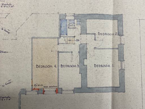
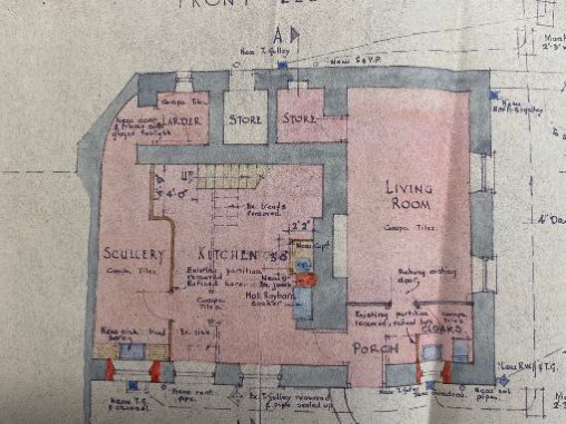
3.2 The next application in 1949 was for an overhead electricity line (IDO 6355) followed by alterations to the farmhouse in 1953 (IDO 9361). This shows the farmhouse laid out as shown here which shows the complicated internal relationship between the two properties:
3.3 Subsequent to this there was permission granted for a feed shed store in 1955 (IDO 11152).
3.4 Permission was sought for the erection of a flat roofed garage in 1970 under IDO 28969 which currently sits to the south west of the farmhouse.
This image displays a hand-drawn architectural floor plan sketch showing a residential layout with four bedrooms and a bathroom. It includes wall dimensions and construction notes along the edges.A detailed architectural floor plan showing the internal layout of a house, including a kitchen, scullery, and living room, with handwritten notes indicating proposed alterations and new walls.A hand-drawn site plan sketch showing the layout of a 'Farm House' and a 'Proposed Extension' adjacent to a 'Farm Yard'.
3.5 A lean-to building was approved in 1973 under IDO 36648, and implement shed under IDO 10057 in 1954, a cow shed and dairy in 1954 (IDO 10187) and a grain silo and wall under IDO 44614 in 1977.
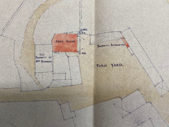
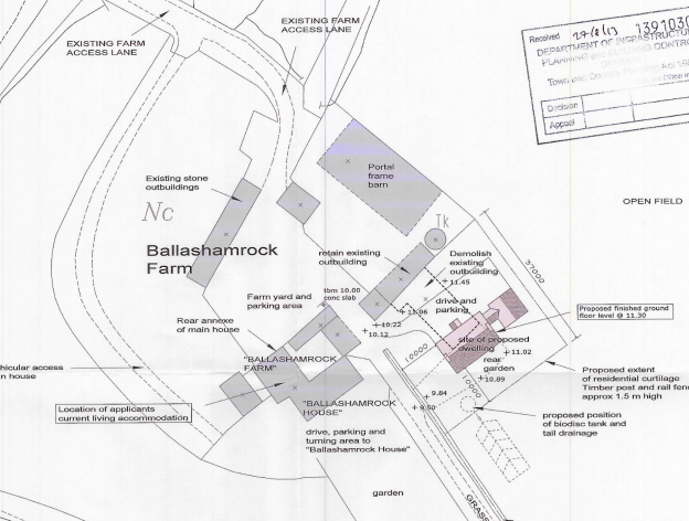
3.6 In more recent times no planning applications have been submitted other than for the erection of a new dwelling in place of an outbuilding which was demolished (13/91030/B). This is now in situ:
A black and white site plan for Ballashamrock Farm showing existing structures like a portal frame barn and proposed new developments including a dwelling and curtilage boundaries.
4.0 The proposal
4.1 Proposed is the renovation of Ballashamrock House, separating the two houses at the point of the main rear elevation of the house. The existing, later side annex is to be demolished but a replacement introduced in its place with a small rear utility and a new family room which extends further forward than the principal elevation and partly wrapping around this front wall but leaving uninterrupted the eight window arrangement in this facade.
4.2 It is the intention of the owners of Ballashamrock Farmhouse to demolish that building and rebuild a new dwelling, detached from the house, between the existing farmhouse and the stone outbuilding to the north west and this is the subject of a concurrent application in principle. The details of this are not proposed at this stage other than the general siting, but if permission is granted the replacement dwelling would comply with the requirements of Housing Policy 14 in respect of size and design.
4.3 The demolition of Ballashamrock Farmhouse and the small parts of the rear of Ballashamrock House which encroach beyond the original four walls of the house will leave Ballashamrock House a simple rectangular footprint, potentially how it would have been when first built. However, if this dwelling is not demolished, the present proposal will be implemented, retaining the farmhouse attached but with a simpler boundary and definition between the two and drawings are provided floor plans and elevations - of the proposed works to Ballashamrock House with and without the attached farmhouse.
4.4 The proposed alterations to Ballashamrock House will retain the original features of the house and replace modern extensions but in a form which is subordinate to the main house and reinforces its character and appearance. The side extension was considered with a pitched roof but it was felt that this brought a suburban character to the building which wasn’t appropriate and instead the applicant has chosen a more contemporary flat roofed approach with parapet and where the length of the extension is visually broken up by stepping the building so that any view from the farmyard and the adjacent house is improved although the existing stone wall forming the curtilage of the house at this point, will screen most of this proposed new fabric.
4.5 The proposed garage is to be built in the position of the existing albeit a little bit closer to the house and further from the trees. Again, a contemporary approach has been used with cladding as an external finish and where the building has a pitched roof to match that on the main house.
4.6 The application includes a tree survey and protection plan which demonstrates that the work will not adversely affect the adjacent woodland which includes Registered Trees. One tree is to be removed to facilitate the front extension. This is an ash which is in advanced stages of ash die back and its removal is considered justified regardless of the proposed planning application. In addition, an established fuchsia and hawthorn hedge will be removed to facilitate the extension. No permission is required for this removal.
4.7 The construction of the proposed garage has the potential to damage the Registered Woodland and as such, a tree protection scheme is part of the application. It should be noted that the existing garage already sits in a similar position and care will be taken during both demolition of the existing garage and construction of the new one, to avoid damage to the existing trees.
5.0 Assessment
5.1 The current arrangement of the two, separate dwellings is such that there is an unusual and uncomfortable layout which has resulted in an irregular and not overly attractive appearance of the farmhouse particularly but the overall appearance of the house as well. The current arrangement does not reflect the original appearance or arrangement of Ballashamrock House and the owner would wish to internally better define the relationship between the two properties, whether or not the farmhouse is retained and improve the amenities of both properties.
5.2 The Strategic Plan provides opportunities for extensions and and for the replacement of existing houses. The appropriate policies to be applied here are whether the proposed extensions to Ballashamrock House comply with Housing Policy 15. Ballashamrock House
5.3 Ballashamrock House has been altered over time with the addition of a rear annex and then Ballashamrock Farmhouse to the rear of that and the flat roofed garage to the south west in 1970 and what appears to be a side extension on the other gable in although there is certainly something in this position, attached to the house in the plans submitted in the 1930s. However it retains its traditional and old core albeit that the windows are now framed in uPVC. This is considered to be traditional so any alterations and extensions to it should respect the proportion, form and appearance of the main house as is required by HP15 and where extensions are generally restricted to no more than 50% of the existing.
5.4 What is proposed is to removed the later additions and to take the house back to its original form:
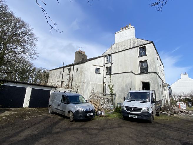
A photograph showing a large white two-story dwelling and an adjacent single-story garage structure with black doors, with two white work vans parked in the foreground.
5.5 The extension will not mimic the pitched roof of the main house nor its height or stature but instead of trying to make the annex look as if it were part of the original dwelling, the development aims to distinguish these later extensions from the main house and emphasise that as the dominant element of the building. The side annex shown in the photographs is flat roofed and what is proposed reflects that but in a larger form but also with decorative parapets which will improve its appearance. What existed was a continuation of the front elevation, giving the impression that it was part of the original house whereas what is now proposed makes it clear that the side building is a separate and later addition which is felt is more sympathetic to the character and appearance of the house.
5.6 The extension will add 69.7 sq m to the floor area prior to the recent demolition of the side extension so complies with the size requirements of Housing Policy 15 (20% increase over the former existing floor area prior to the side extension being demolished.
5.7 It is submitted that the proposal will restore the character of the house whether or not the farmhouse is demolished and provide an acceptable modern home whilst respecting the historic and architectural features of the original house. The only tree to be removed is one which is in advanced stages of ash die back and whilst a length of hedge is to be removed, the majority will remain and what is to be removed is that part closest to the house and subject to most pedestrian traffic, being the least valuable of all of its length, for ecology.
Sarah Corlett 04.11.2022
Appendix One - policies Strategic Plan General Policy 3: Development will not be permitted outside of those areas which are zoned for development on the appropriate Area Plan with the exception of:
(a) essential housing for agricultural workers who have to live close to their place of work; (Housing Policies 7, 8, 9 and 10);
(b) conversion of redundant rural buildings which are of architectural, historic, or social value and interest; (Housing Policy 11);
(c) previously developed land(1) which contains a significant amount of building; where the continued use is redundant; where redevelopment would reduce the impact of the current situation on the landscape or the wider environment; and where the development proposed would result in improvements to the landscape or wider environment;
(d) the replacement of existing rural dwellings; (Housing Policies 12, 13 and 14);
(e) location-dependent development in connection with the working of minerals or the provision of necessary services;
(f) building and engineering operations which are essential for the conduct of agriculture or forestry;
(g) development recognised to be of overriding national need in land use planning terms and for which there is no reasonable and acceptable alternative; and
(h) buildings or works required for interpretation of the countryside, its wildlife or heritage.
Environment Policy 1: The countryside and its ecology will be protected for its own sake. For the purposes of this policy, the countryside comprises all land which is outside the settlements defined in Appendix 3 at A.3.6 or which is not designated for future development on an Area Plan. Development which would adversely affect the countryside will not be permitted unless there is an over-riding national need in land use planning terms which outweighs the requirement to protect these areas and for which there is no reasonable and acceptable alternative.
Environment Policy 2: The present system of landscape classification of Areas of High Landscape or Coastal Value and Scenic Significance (AHLV’s) as shown on the 1982 Development Plan and subsequent Local and Area Plans will be used as a basis for development control until such time as it is superseded by a landscape classification which will introduce different categories of landscape and policies and guidance for control therein. Within these areas the protection of the character of the landscape will be the most important consideration unless it can be shown that:
(a) the development would not harm the character and quality of the landscape; or
(b) the location for the development is essential.
Environment Policy 3: Development will not be permitted where it would result in the unacceptable loss of or damage to woodland areas, especially ancient, natural and semi-natural woodlands, which have public amenity or conservation value.
Environment Policy 16: The use of existing rural buildings for new purposes such as tourist, or small-scale industrial/commercial use may be permitted where:
a) it is demonstrated that the building is no longer required for its original purpose and where the building is substantially intact and structurally capable of renovation;
b) the reuse of the building will result in the preservation of fabric which is of historic, architectural, or social interest or is otherwise of visual attraction;
c) it is demonstrated that the building could accommodate the new use without requiring extension or adverse change to appearance or character;
d) there would not be unacceptable implications in terms of traffic generation;
e) conversion does not lead to dispersal of activity on such a scale as to prejudice the vitality and viability of existing town and village services; and
f) the use of existing buildings involves significant levels of redevelopment to accommodate the new use, the benefits secured by the proposal in terms of impact on the environment and the rural economy shall outweigh the continued impact of retaining the existing buildings on site.
Proposals to convert rural buildings to residential accommodation will be considered along with the advice given at Section 8.10 of this document.
Housing Policy 11: Conversion of existing rural buildings into dwellings may be permitted, but only where:
(a) redundancy for the original use can be established;
(b) the building is substantially intact and structurally capable of renovation;
(c) the building is of architectural, historic, or social interest;
(d) the building is large enough to form a satisfactory dwelling, either as it stands or with modest, subordinate extension which does not affect adversely the character or interest of the building;
(e) residential use would not be incompatible with adjoining established uses or, where appropriate, land-use zonings on the area plan; and
(f) the building is or can be provided with satisfactory services without unreasonable public expenditure. Such conversion must:
(a) where practicable and desirable, re-establish the original appearance of the building; and
(b) use the same materials as those in the existing building. Permission will not be given for the rebuilding of ruins or the erection of replacement buildings of similar, or even identical, form.
Further extension of converted rural buildings will not usually be permitted, since this would lead to loss or reduction of the original interest and character.
Housing Policy 12: The replacement of an existing dwelling in the countryside will generally be permitted unless:
(a) the existing building has lost its residential use by abandonment; or
(b) the existing dwelling is of architectural or historic interest and is capable of renovation.
In assessing whether a property has lost its habitable status(1) by abandonment, regard will be had to the following criteria: (i) the structural condition of the building;
(ii) the period of non-residential use(2) or non-use in excess of ten years;
(iii) evidence of intervening use; and
(iv) evidence of intention, or otherwise, to abandon.
Housing Policy 13: In the case of those rural dwellings which have lost their former residential use by abandonment, consideration will be given in the following circumstances to the formation of a dwelling by use of the remaining fabric and the addition of new fabric to replace that which has been lost. Where:
a) the building is substantially intact; this will involve there being at least three of the walls, standing up to eaves level and structurally capable of being retained; and
b) there is an existing, usable track from the highway; and where
c) a supply of fresh potable water and of electricity can be made available from existing services within the highway.
(1) Habitable Status is defined in Appendix 1
(2) Non residential use is defined in Appendix 1 74 This policy will not apply in National Heritage Areas (see Environment Policy 6). Permission will not be given for the use of buildings more ruinous than those in (a) above, or for the erection of replacement buildings. Extensions of dwellings formed in accordance with the above may be permitted if the extension is clearly subordinate to the original building (i.e. in terms of floor space(3) measured externally, the extension measures less than 50% of that of the original).
8.11.2 It is important that replacement dwellings should relate closely to the buildings they replace in terms of siting and size, that the resulting visual impact is appropriate for the countryside, and that existing stone and slate are re-used.
Housing Policy 14: Where a replacement dwelling is permitted, it must not be substantially different to the existing in terms of siting and size, unless changes of siting or size would result in an overall environmental improvement; the new building should therefore generally be sited on the “footprint” of the existing, and should have a floor area(1), which is not more than 50% greater than that of the original building (floor areas should be measured externally and should not include attic space or outbuildings). Generally, the design of the new building should be in accordance with Policies 2- 7 of the present Planning Circular 3/91, (which will be revised and issued as a Planning Policy Statement). Exceptionally, permission may be granted for buildings of innovative, modern design where this is of high quality and would not result in adverse visual impact; designs should incorporate the re-use of such stone and slate as are still in place on the site, and in general, new fabric should be finished to match the materials of the original building.
Consideration may be given to proposals which result in a larger dwelling where this involves the replacement of an existing dwelling of poor form with one of more traditional character, or where, by its design or siting, there would be less visual impact.
Housing Policy 15: The extension or alteration of existing traditionally styled properties in the countryside will normally only be approved where these respect the proportion, form and appearance of the existing property. Only exceptionally will permission be granted for extensions which measure more than 50% of the existing building in terms of floor space (measured externally).
Appendix Two Landscape Character Assessment D13 - SANTON Key Characteristics
• A predominantly rural landscape, dissected by A5 and A25 roads.
• Densely wooded valley bottoms amongst undulating rolling land with large rectilinear arable and pastoral fields on the gently sloping hill sides and rounded tops.
• Steep sided densely wooded Victorian pleasure Glens of Glen Grenaugh and Port Soderick Glen lead down to the coast.
• Victorian electric railway line and stations runs through the area at the bottom of Crogga Glen.
• Fragmented woodland along field boundaries and along tracks that access the scattered farm houses centred around Quine’s Hill (along the A25) and small settlements of Santon and Ballaveare.
• Sea-facing hill slopes with large open fields running along the cliff tops with gorse, heather and bracken along the cliff top periphery.
• Incinerator chimney forms notable landmark in the immediate area.
• Presence of Manx Milestones.
• Abrupt linear southern built edge to Douglas, comprising residential and industrial development with minor localised extension of industrial character into character area south of Cooil Road.
• Pulrose Golf Course on edge of Douglas
Overall Character Description Numerous gentle to steeply sided river valleys cut down into the landform to form an undulating and rolling character with pronounced incised valleys. Glen Grenaugh and Port Soderick Glen are steepsided densely wooded valleys, the latter appropriated during the Victorian period as pleasure Glens with walkways and features such as bandstands and bridges. Linear fragmented woodland runs along the valley bottoms of these National Glens and along Crogga River. Hedgerow trees and woodland blocks surround the numerous farms in the area, which are predominantly located in the north of the area around Quine’s Hill.
Medium sized rectilinear arable and pastoral fields delineated predominantly by Manx hedges and some post and wire fences form a strong geometric field pattern on the gently sloping hill sides and rounded tops in the south of the area. Smaller rectilinear fields enclosed by Manx hedgerows, containing large hedgerow trees, cover the more settled north-eastern area where farmsteads such as Hampton Court and Cronkbane are concentrated. This field pattern stops abruptly in the north of the area where it meets the A24 and the linear built-up edge of Douglas. The far north-eastern part of the area comprises the Pulrose Golf Course, which extends in towards the centre of Douglas. Patches of gorse and heather grow in areas on the more exposed hill tops and along the eastern edges of the fields of the coastal facing slopes, along which the cliff top coastal path runs and forms the area’s seaward boundary.
The busy A25 runs along the lower valley sides with small, often steep and winding tracks branching off perpendicular from the main road to provide farm access, while smaller predominantly straight B roads, enclosed by tall hedgerow vegetation, which follow the grain of the rectilinear field pattern and link the small and wooded settlements within the area such as Santon and Seafield. The Victorian Electric Railway runs through the area along Crogga Glen with stations at Santon and Port Soderick before skirting around the bottom of Douglas Head which forms the north eastern boundary. Moderate sense of tranquillity away from Douglas and the major roads.
Key Views
• Open and expansive views from the higher areas along the rugged coast in the east and inland towards the upland areas over Braaid.
• Incinerator chimney forms a notable landmark in the immediate area.
• Glimpsed views framed by vegetation in the valley bottoms and along the main roads where they follow the wooded valley bottoms.
• Views in the northern part of the area up to the Transmitting Masts on top of Douglas Head hill top.
• Views from Isle of Man Steam Railway Historic Features
• Victorian Isle of Man Steam Railway and stations, including Port Soderick (Registered Building) and the Old Toll Booth (Registered Building). Ecological Features
• Farmland grassland habitats. • Mature network of hedgerows containing deciduous trees in field boundaries.
• Aquatic and waterside habitats along river courses.
• Dense riparian woodland in Valley bottom with deciduous woodland along valley sides.
• Exposed heathland on steeper sea facing slopes. Key Issues and landscape sensitivities • Wooded horizons and skyline seen from valley bottoms.
• Ecological value of the aquatic and waterside habitats.
• Various sized pastoral and arable fields with Manx hedges. • Wooded valley bottom with fragmented woodland along substantial field boundaries.
• Scattered farmsteads fringed by trees.
• Wooded Victorian Pleasure Glen at Port Soderick.
• Victorian Isle of Man Steam Railway and stations.
• Presence of Manx Milestones.
Landscape Strategy The overall strategy should be to conserve and enhance the character, quality and distinctiveness of the area, with its wooded valley bottoms and wooded horizons, its scattered settlement pattern, its Victorian pleasure glen and the railway.
Copyright in submitted documents remains with their authors. Request removal