Planning Statement In Support Of The Installation Of Three Glamping Pods/Bell Tent And Creation Of Additional Parking Area, Land Off Kella Road, Sulby, Lezayre Im7 2Hg
1.0 INTRODUCTION
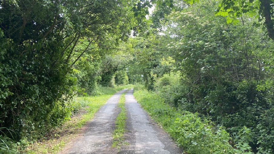
1.1 The site is a small parcel of land which measures approximately half a hectare (1.3 acres) sitting on the northern side of the Kella Road, a minor road which leads from Sulby Village in the south to the A14 Clenagh Road which links Sulby Glen crossroads with Sandygate.
1.2 The road is largely single track and limited to a weight of 10 tons. In places there is a grass strip growing from the centre of the carriageway. There is no footway.
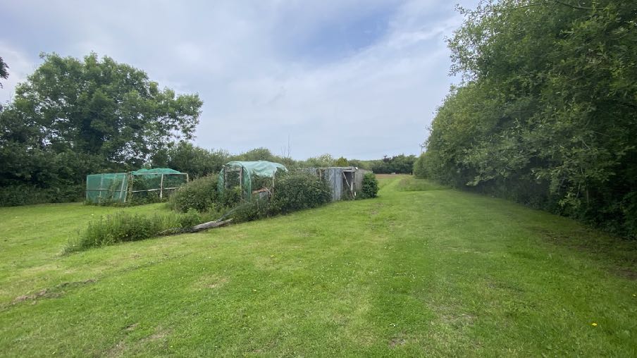
1.3 The site is flat and is mainly laid to grass. The northern section is wooded with a small fence separating the grass section to the south and a pedestrian gate within it to provide access on foot to the wooded area.
1.4 Access is available to pedestrians and vehicles from the Kella Road. There is a gate providing vehicular access into the site, set back from the highway. Visibility splays of 2.4m by 70m are available from this entrance to the nearest part of the used carriageway (demonstrated by the worn area of tarmacadam).
1.5 Within the site, directly from the access gate is a small hard surfaced parking and turning area surrounded by low, vertical fencing.
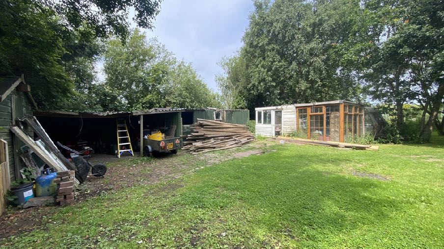
1.6 Within the site are a number of structures. There is a caravan which sits alongside a rectangular structure whose most recent use was as living accommodation, occupied by the previous owner. Alongside this to the west is a long sheeted, flat roofed shed and to the south of that is a timber, pitched roofed shed.
A photograph of a rural site featuring existing wooden sheds, a pile of timber, and a caravan with a wooden conservatory extension surrounded by trees.
1.7 There is then a line of trees, to the north of which are fruit trees and just beyondthat, fruit cases, a small polytunnel and a small flat roofed timber shed.
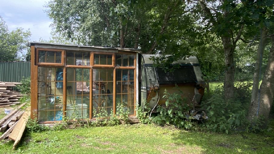
A photograph showing a wooden structure with large windows, resembling a greenhouse or sunroom, situated next to a dilapidated caravan in a grassy, wooded area.
1.8 To the north of these small structures is a large area which is currently laid to grass.
1.9 The site is well screened from the surrounding area by established, substantial willow hedges.
1.10 The site has the benefit of a Certificate of Lawful Development for the sheds, store, caravan, sunroom and sitting room in terms of these structures with no approval being given to the use of these structures for anything other than agriculture (24/00768/B). Whilst the caravan, sitting room and sunroom have clearly been used for living accommodation, there was not sufficient evidence provided at the time to demonstrate that they had been a residential facility for the required ten years.
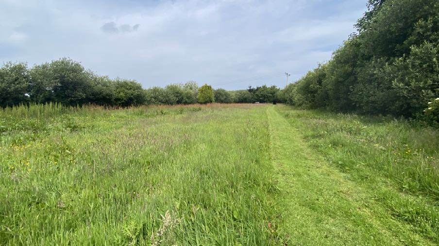
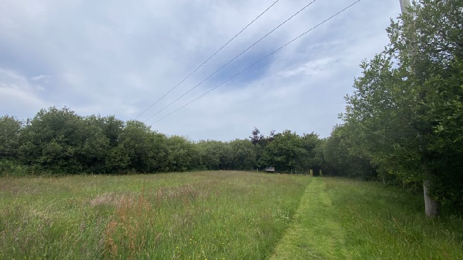
1.11 An overhead electricity line runs across the grassed part of the site.
View towards the north of the site showing the overhead electricity supply
2.0 PLANNING POLICY Isle of Man Planning Scheme (Development Plan) Order 1982
2.1 The only adopted land use development plan for this area is the above. The site lies within an area designated as not for a particular purpose. The site is outwith any Area of High Landscape or Coastal Value and Scenic Significance.
Draft Area Plan for the North and West (APNW)
2.2 This plan, which was intended to replace the provisions of the Isle of Man Planning Scheme (Development Plan) Order 1982 and all other adopted local plans in the study area, was commenced in 2019 and proceeded through a public inquiry but was not approved in Tynwald after two attempts in October and November this year.
2.3 There is, nevertheless useful factual data contained within the plan documents which can be referred to although the plan itself has no material weight in the planning process.
2.4 The APNW has additional Constraints maps which accompany the development plan and written statement. The Infrastructural Constraints map shows nothing applying to the site other than the electricity line running through it. The site is not shown as being at risk of flooding.
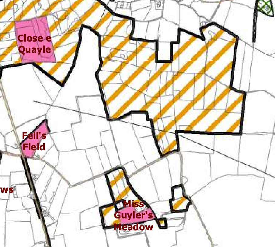
2.5 The Environmental Constraints map shows the site as being one of ecological interest although there are no identified wildlife or protected sites on the Island Environment map. The area of ecological interest is a significant one, extending to the north and incorporating the Close e Quayle ASSI: the site is identified in a red circle on the excerpt from the Environmental Constraints map below:
2.6 The Isle of Man Planning Scheme (Development Plan) Order 1982 contains, amongst other things, a system of landscape quality designation where land is either designated as of High Landscape or Coastal Value and Scenic Significance or it isn’t. The Strategic Plan (see later) refers to this but also to a proposed replacement of this system by a system of different categories of landscape and policies and guidance for control therein (Environment Policy 2).
A site plan map displaying land parcels with thick black boundaries, yellow diagonal hatching, and pink highlighted areas labeled with field names.
2.7 The Department commissioned an exercise where the Island would be subdivided into landscape character types along with guidance as to if and how such areas should be protected and developed. This Assessment, published in 2008 is being gradually introduced through the adoption of Area Plans of which there are already ones for the South (2013) and the East (2020) with the remainder of the Island to have been incorporated in the draft Area Plan for the North and West.
2.8 The full extent of the Assessment is set out in Appendix One of this document and the summary of this as set out below:
The overall strategy should be to conserve and enhance the character, quality and distinctiveness of this rural area with its scattered settlement pattern, relatively strong field pattern and enclosed network of minor rural roads.
Isle of Man Strategic Plan (2016)
2.9 This provides overarching planning policy guidance on development on the Island. It contains a range of policies which require that development protects and enhances our environment (Strategic Policies 4 and 5, Environment Policy 42) and also which directs new development generally to designated sites in existing settlements (Spatial Policy 5, Strategic Policies 1, 2 and 10 and Transport Policy 1).
2.10 Development in undesignated areas is generally presumed against (General Policy 2) and whilst there are a number of exceptions listed, none relates to tourism development.
2.11 Tourism development is acknowledged in the Strategic Plan as “an important element in the Island’s economy” (paragraph 9.5.1) and that “In recognition of this the Department proposes that new forms of contemporary tourism development will be welcomed, particularly those that satisfy customer demand for high quality accommodation in rural areas provided that they comply with the policies in the plan.”
2.12 It goes on, “It is important that a balance be struck between the needs of tourism and the protection of these assets, and that tourism development should be sustainable in accordance with the objectives of this plan. There is no special reason why less demanding policies should be applied to tourism development than for other types of development in the countryside...”
2.13 Notwithstanding this presumption against development in the countryside, the Government’s Tourism Strategy - Our Island, Our Future - confirms the importance of tourism to the Island economy, generating a visitor spend of £142m in 2019 but with the potential for improvement. It also notes that “Well managed, sustainable visitor discovery and enjoyment of the Island’s seas, coastline and countryside can also make a positive contribution to the conservation goals of UNESCO Biosphere Isle of Man. Redesigning the Island’s visitor industry to eliminate its carbon footprint has a key contribution to make to the Island’s Climate Change Plan.”
2.14 The Strategy includes the objectives of transforming the offer of visitor accommodation and specifically back t back nature retreats, lifestyle and wellness resources and luxury glamping sites which is distinctly Manx.
2.15 The Strategic Plan provides a suite of other protective policies:
Environment Policy 3 protects trees of amenity value Environment Policies 4 and 7 protect wildlife Environment Policy 14 protects the highest quality agricultural land (the site is understood to be within an area of Class 3/4 so not protected by this policy) and Environment Policy 22 protects the environment from pollution including noise.
2.16 Development is expected to have an acceptable impact on the highway network and have sufficient on site car parking (Transport Policies 4 and 7).
3.0 PLANNING HISTORY
3.1 The site has only been the subject of one previous application, that being for the Certificate of Lawful Development referred to above.
3.2 In other parts of the Island, planning approval has been sought for tourist related development. In East Baldwin in Ballawyllin Farm, planning approval was granted for two free standing cabins to complement the existing bed and breakfast and complimentary therapy facility operated at that site as well as approval that was granted for the additional use of an existing detached cottage within the grounds, as tourist accommodation (16/00314/B and 13/00842/C).
3.3 A larger scale tourist development was approved at Knockaloe Beg Farm in Patrick comprising tourist units formed from existing outbuildings with a cafe and yurts in the field to the rear (20/00488/B, 16/00212/C, 14/00460/B, 12/00083/C, 06/02242/B, 05/92183/B).
3.4 Camp sites have also been approved on existing farms at Silly Moos in Lezayre (18/00010/B), Glenlough Farm (21/00349/B, 12/00057/B, 12/00052/B, 11/00549/B), Glendown Farm in Port St. Mary/Port Erin (17/01186/B, 17/00620/B, 14/00800/B, 03/00806/B) and Ballamoar Farm in Ballaugh (16/00549/B, 16/00545/B and 12/00136/B)
3.5 Perhaps the largest scale recent development approved was at Port Erin (20/00496/B and 21/01009/B). This was for 30 glamping pods and cabins, tented and motorhome camping and a welcome centre.
3.6 Permission was recently granted to the conversion of a dwelling to three tourist units at Broogh Fort, Santon (22/01064/B) where the inspector refers to the Government Tourism Strategy and the employment benefit of that proposal.
3.7 Permission was also recently granted for two new camp sites in the north of the Island - 24/90966/B and 24/91030/B both including provision for tented camping and motorhome pitches and one also providing shepherds’ huts.
4.0 THE PROPOSAL
4.1 Proposed is the use of the site for tourist accommodation incorporating the introduction of 3 shepherds’ huts (one with an alternative bell tent) with the erection of a building for storage associated with the tourist accommodation. Also proposed is a drainage system and the installation of solar panels.
4.2 The development will involve the removal of the existing caravan and the structure that currently accommodates a sun room and sitting room and in its place will be positioned one of the shepherds’ huts.
4.3 The existing store to the south of the caravan and attached accommodation will be replaced with a new building which is approximately 83cm taller and around the same size on the same footprint: the proposed building is marginally smaller in area. The shepherd’s hut alongside is a similar height with the flue serving the heating stove protruding above this.
4.4 The shepherd’s hut will have a double bed with small kitchen area and a shower room. A small deck area will be installed in front of the entrance doors to the south of the hut.
4.5 The two further shepherds’ huts will be positioned further north on the site and will be the same size and shape and incorporating the same facilities and deck. The northernmost hut is shown alongside a circular bell tent which is proposed as an alternative unit of accommodation in lieu of the hut.
4.6 A new drainage system is to be introduced in the form of a Bio Disc wastewater treatment works with associated soakaway to the west. All of this is to be installed in areas which are presently grassed. No trees or existing shrubs are to be removed or affected by the proposal.
4.7 Finally, the existing store positioned part way up the site is to be replaced by a new mono pitch roofed store which is around 70cm taller than what exists and a slightly larger footprint (3.6m by 6.3m compared with the existing at 5.6m by 2.3m).
4.8 This building will have solar panels installed on the south facing roof plane.
4.9 Parking spaces - at least three - will be available at the southern end of the site in the area of existing hard surfacing. The means of access will remain as it currently exists.
4.10 None of the structures will be within 9m of the route of the overhead power line.
5.0 PLANNING ASSESSMENT
5.1 The site is not designated for a particular purpose so there is a presumption against development as stated in General Policy 3. Tourism developments are not currently one of the exceptions to this policy. However, as the Town and Country Planning Act 1999 requires the determination of planning applications to consider “all other material considerations” as well as the development plan, development order or relevant statement of planning policy there are other considerations which will be material to the determination of the application and indeed have proved as such in other cases some of which are listed Section 3 above.
5.2 The Government’s Economic and Tourism Strategies are considered to be such material considerations in this case. Both encourage the expansion of the local economy and of employment opportunities, both considering the tourism industry as an important element for both. The Tourism Strategy aims to increase the number of visitors and visitor spending over the Strategy period - 2022 -2032 to 500,000 visitors per annum and £310m annual visitor spend. The Strategy identifies the ways in which these objectives may be attained, identifying, amongst other things, the improvement and transformation of our visitor accommodation, stating specifically:
The progression of a series of Island-wide visitor accommodation development initiatives, including a cabin and bothies network around the Island to support the Raad Ny Foillan coastal path and round-island cycle, car, motorbike and kayak touring; a motorhome stopovers network around the Island; a pub accommodation development programme; a sky huts and star camps initiative; and the development of a distinctive Manx glamping offer.
5.3 This application aims to create a very natural and unobtrusive glamping experience for those who would like to stay in a remote site with comfortable accommodation in a natural environment. The site is well placed for nature walks, safe and interesting cycle routes as well as being within comfortable cycling or even walking distance of Sulby and its shop and public houses. It is also close to the TT Course for visitors with an interest in motorcycling.
5.4 The nature of the accommodation renders it suitable for accommodating visitors all year round, this supporting the Government’s objective off widening the non services accommodation supply and extending the tourist season beyond the traditional spring and summer months.
5.5 It is the case that developments which support the Tourism Strategy have been considered acceptable and in this case, the nature of the proposal is for shepherds’ huts and/or one bell tent which are removable such that were the project to cease for any reason, the accommodation could be removed and the site return to its former/ current state.
5.6 Whilst the sheds which are proposed are more permanent structures, they both replace buildings which already exist and for which there is a Certificate of Lawfulness. Even if the tourist accommodation is not on site, there will be a need for the storage of implements and items required for the maintenance of the site, noting the applicants’ desire to enhance the ecological and biodiversity value of the site.
5.7 The proposed development will generate a modest increase in traffic coming and going to and from the site. However, the road serving the site is very lightly trafficked and is capable of accommodating the slight increase in its use as a result of the proposed development.
5.8 The Ecological Report which accompanies the application confirms that the ecological value of the site itself is very low with the only biodiversity value found in the boundary hedges which are not to be affected by the proposal. The report concludes that the proposed use is unlikely to have any significant negative effect on the wildlife value of the site and the main potential impact would come with the management of the site. It should be noted that there is nothing currently to prevent the site from being ploughed or grazed by any form of livestock, both of which would not enhance (but neither reduce) the biodiversity value of the site. However, the proposed use will retain large areas of grass which are not proposed to be domesticated and will remain managed and thus more conducive to ecological enhancement than would be the case if the field were used for agriculture.
5.9 The application is happy to maintain the site largely in accordance with the recommended management plan, although the grass may need to be mown more regularly and they are concerned that any water body could pose a risk to anyone staying on the site, particularly children. They have no intention of changing any existing marshy areas within the site, which will remain as they are naturally.
5.10 We would submit that the proposed use is more likely to result in a biodiversity enhancement than would agricultural use or no use at all and the proposal itself is not harmful to biodiversity and would result in no net loss with the potential for biodiversity net gain. The applicant is keen to attract visitors to this site who appreciate the natural setting and the wildlife which is within and surrounds it and therefore the increase in any human activity on the site would not be harmful.
5.11 We would conclude that the proposed use would not be environmentally harmful but would find a positive use for this small site which is too small to form a viable agricultural unit and whose agricultural use may not be as beneficial a use as would the proposed one. The access is acceptable and parking provided: the units would be within a safe distance of the overhead power supply and the appearance of the site, although generally hidden from view - would improve as a result of the removal of old and unattractive buildings and their replacement with newer ones, many of which are not permanent. The proposal would support the Economic and Tourism Strategies and not contravene any of the planning policies which seek to protect the countryside. Whilst there is no provision in General Policy 3 for tourism development on land which is not designated for development, it is clear from the examples given that exceptions can be and have been made for acceptable forms of tourism development which have no harmful and ideally a beneficial impact on the countryside.
Sarah Corlett 25.11.25
APPENDIX ONE
EXCERPT FROM THE LANDSCAPE CHARACTER ASSESSMENT 2008 F4 Undulating Lowland Plain F4 SULBY Key Characteristics
• Predominantly flat landscape underlain by subdued mounds of sand and gravels.
• Belt of farmland, running east-west and consisting of a patchwork of predominantly arable fields (interspersed with patches of rough grassland and pasture).
• Fields delineated by a combination of mature Manx hedgerows and simple post and wire fences.
• Main A3 (TT course) and A13 roads run east-west across the area, connected by several northsouth running minor rural roads.
• Predominantly rural character, with built character dominated by traditional Manx architecture.
• Strong sense of tranquillity at distance from A13, A3 and Ramsey.
• Strong sense of place throughout the area, provided in part, by views to the dramatic skyline of the Northern Uplands.
• Black and white Manx milestones lining the path of the A3.
Overall Character Description Underlain by platforms and subdued mounds of sand and gravels, landscape within this area is predominantly flat (to very slightly undulating) and is situated on the northern plain, to the north of the Northern Uplands. This character area forms an east-west belt of farmland, which lies adjacent to the Curragh (to the west), Sulby River Valley (at the base of the uplands to the south) and Ramsey (to the east). A patchwork of predominantly arable fields (interspersed with small patches of rough grassland and pasture) dominates the character of the area. Field boundaries delineated by a combination of mature hedgerows and simple post and wire fences. Occasional drainage ditches are also visible at field boundaries. Medium to largescale arable fields dominate the pattern of the eastern half of the character area.
Further to the west, a belt of intricate, small-scale irregular fields, delineated by a network of mature hedgerows, stretches from the east of the Curraghs and south of St. Jude's. The main A3 and A13 roads roughly follow the southern and northern boundaries of the area respectively. Several minor connecting rural roads run at right angles (north-south) to the main roads. Settlement patterns are relatively isolated, consisting of scattered farmsteads, houses small hamlets such as St. Jude’s. Traditional architecture is similar to other adjacent character areas, with a small, yet distinctive church at St. Jude’s. The landscape within the eastern part of the area abuts the western urban edge of Ramsey, facilitating views both into and out of the urban area. The built character of the urban edge has an impact upon the otherwise predominantly rural character of the area. There is a strong sense of tranquillity at distance from A3, A13 and the urban edge of Ramsey. Throughout the area a strong recognisable sense of place is provided in part by views to the skyline of the imposing and dramatic uplands to the south. The A3 is lined with sporadic distinctive black and white Manx milestones and the instantly recognisable black and white kerbs denoting the TT course. Sense of tranquillity is greatly disturbed during TT season.
Key Views
• Dramatic views southwards to the imposing skyline of the uplands, which often provide a dark contrast to the adjacent landscape.
• Relatively open views across farmland, framed in places by mature hedgerows.
• Views into and out of the western urban edge of Ramsey (at the eastern edge of the character area).
Historic Features
• St. Jude's Church.
• Fort Ballachurry.
Ecological Features
• Species-rich verges.
• Mature hedgerows at field boundaries.
Evaluation of Inherent Landscape Sensitivities
• Strong sense of tranquillity away from main roads.
• Scattered isolated settlement pattern.
• Minor rural roads enclosed by roadside vegetation.
• Vernacular character of buildings and churches.
• Presence of Manx Mile stones.
• Few vertical elements.
• Dramatic views south to Uplands.
• Field pattern delineated by a mixture of stone walls, relatively tall Manx hedgebanks and post and wire fences.
Landscape Strategy The overall strategy should be to conserve and enhance the character, quality and distinctiveness of this rural area with its scattered settlement pattern, relatively strong field pattern and enclosed network of minor rural roads.
Copyright in submitted documents remains with their authors. Request removal