Loading document...
The purpose of this detailed planning application is to seek planning permission for the conversion of an existing building into a single, private residential unit with inclusion of off-road integral parking within the existing property. The works would be mainly internal with the exception of a structural alteration to the South Elevation to remove a pair of existing timber doors and widen the opening to accept a vertical opening garage door providing vehicular access into the ground floor area. Two new windows would be fitted within existing apertures at ground floor level to the East Elevation and an existing window would be removed, the masonry below cill level broken out and removed to floor level, and a new entrance door with glazed sidelights would then be fitted under the existing lintols to provide pedestrian access into the proposed dwelling. This aperture is also on the East Elevation at ground floor level.
Installation of all other windows, french doors and provision of juliette balconies, together with re-rendering of the south facing gable wall, have already been undertaken as part of a previously approved planning application.
The site for the proposed dwelling is a four storey warehouse, formerly used as a bakery, but currently having the benefit of approval for conversion into Office accommodation at ground floor level with three two Bedroom self contained apartments being placed on the upper three floors. The building has natural Manx stone facings to three Elevations and plain cement rendered and painted gable wall to the south elevation. Internally, the floor areas are clear spaces as indicated on the Survey Drawing number SM22/574/2. The building currently has a concrete tiled roof and permission has previously been granted for replacing the roof covering with new roof tiles.
Works have been commenced on conversion of the property into the approved Office accommodation and apartments on the three upper floors and this scheme This was approved under P.A.08/00596/B. Building regulation approval was also granted for the proposed conversion works and this approval has also been activated. Within the approved planning application, a new Dormer window was shown to the West Elevation at roof level to provide an extra Bedroom within the third floor apartment.
No off-road car parking was included within the approved planning application as the site is contained within the Town Centre and has no available additional space for the use of off-road car parking.
Conversion and upgrading works have taken place but the scheme has not been finalised.
Photographs indicating all Elevations of the existing building have been included at APPENDIX 1.
The building is contained within a Mixed Use area within the Town Centre as indicated on the Isle of Man Planning Scheme (Ramsey Local Plan) (No.2) Order 1998. The property is bounded to the north by a retail outlet, which also faces on to Parliament Street, and has living accommodation above, to the south by an open yard and range of garage and storage buildings previously used as a funeral parlour and funeral directors premises, and, directly (and attached) to the west by a re-built storage building owned by the Co-operative Society. The East Elevation of the property fronts directly on to a public footpath abutting Christian Street. In the wider area there are a range of retail and Office units with self-contained apartments or living accommodation on the upper floors.
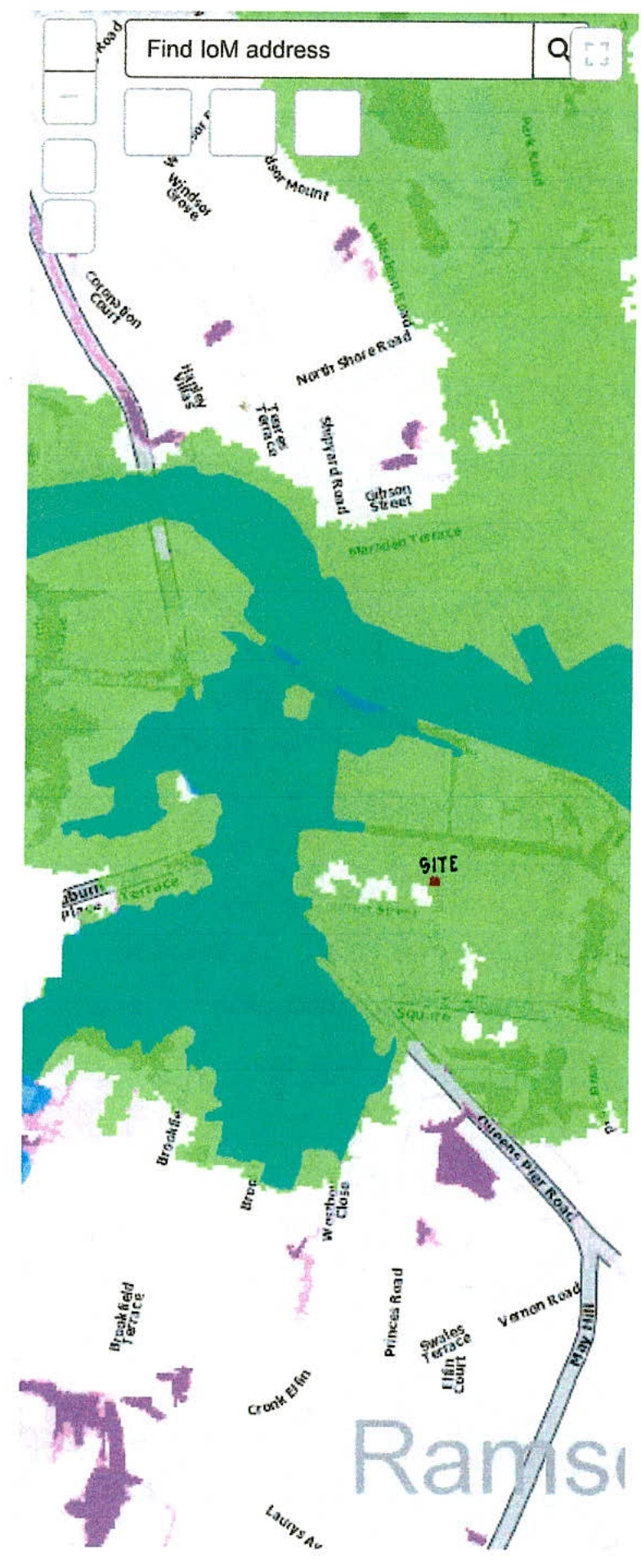
The property is contained within an area designated as being within a High Risk Flood Zone (Tidal) according to the Department of Infrastructure Flood Risk Viewer and a copy of their map, with the Christian Street premises marked in red, is enclosed at APPENDIX 2.
Although the Applicant has owned the property for some twenty years, even during periods of extremely high tides and flooding in Parliament Street and some of the side streets between East Quay, West Quay and the main thoroughfares in Ramsey, these premises have never flooded or been affected in any way by the high tides which have affected the Town.
The Applicant is aware of the Flood Risk designation and would be happy, in the event of the planning application being approved, to ensure that all electrical fittings set within the Ground Floor garage and storage area would be set at an acceptable height above ground floor level to comply with building regulation requirements and to ensure that, in the event of flooding, the electrical system would be set well above any water flood level.
Floodgate, or similar proprietary flood gates or barriers, could be placed across the garage door threshold and the main pedestrian access off Christian Street as part of any new works if required.
It should be highlighted that this building has never suffered from flooding and that the current floor level for the ground floor area to be used as garaging is some 200 mm above the footpath level in Christian Street and that the proposed Ground Floor Hall level would be a further step above the garage level and some 400 mm above the footpath level abutting Christian Street.
The building is contained within the Town Centre and currently has planning approval for of its footprint to be used for private residential purposes. The currently approved planning application shows that the ground floor level would be used for Office accommodation. As the building does not have a purpose built type of shop front normally found in retail outlets, it did not lend itself to a retail use and this, coupled with the fact that the property it is set within Christian Street, not a main part of the Ramsey shopping experience, led to the original application seeking an Office use. However, given the extent of available Office space within the Town, the loss of this minimal area to a private residential use should not cause any problem.
The current approved use as apartments provides six Bedrooms with no off-road parking, the apartments themselves would have provided good quality living accommodation with a sunny, southern facing outlook to the main Living Rooms and Kitchen areas within each unit. The aspect from the upper floors of the building, and within each proposed apartment, is over an adjacent open yard, and then looking up towards Barrule and this would be considered to be clear, pleasant and sunny outlook and in no way restricted or claustrophobic.
The proposed use of the building as a single residential unit, reduces the number of Bedrooms to four (five if the Home Office was included) but has the added advantage of off-road parking for at least one vehicle together with bicycle and general storage.
The Ramsey Bus Station is in the immediate vicinity, a short walk across Albert Road to the main depot.
There is no outside amenity space in the form of garden areas but, as part of the proposal, a small Dormer window has been included in a similar manner to the one already approved, but the space would now take the form of an outside roof terrace with an internal staircase running up from the Third Floor Lounge, Dining Room and Kitchen areas which covers the whole of the Third Floor.
The proposed residential unit would have similar facilities to those upper floor apartments and single residential units set above retail outlets but with the added bonus of off-road parking and an upper level, private open space.
The property, being set within the Town Centre, is close to all attractions and leisure activities the Town has to offer within close walking distance of the building.
An electric passenger lift has also been included within the building to travel from ground up to third floor as well as the staircase arrangement as shown.
The proposed conversion, whilst eliminating three proposed self-contained apartments, would provide spacious Town Centre living accommodation set in the heart of the Town.
WEST ELEVATION OF WAREHOUSE SITING ABOVE EXISTING STORAGE BUILDING IN OWNERSHIP OF THE CO-OPERATIVE SOCIETY.
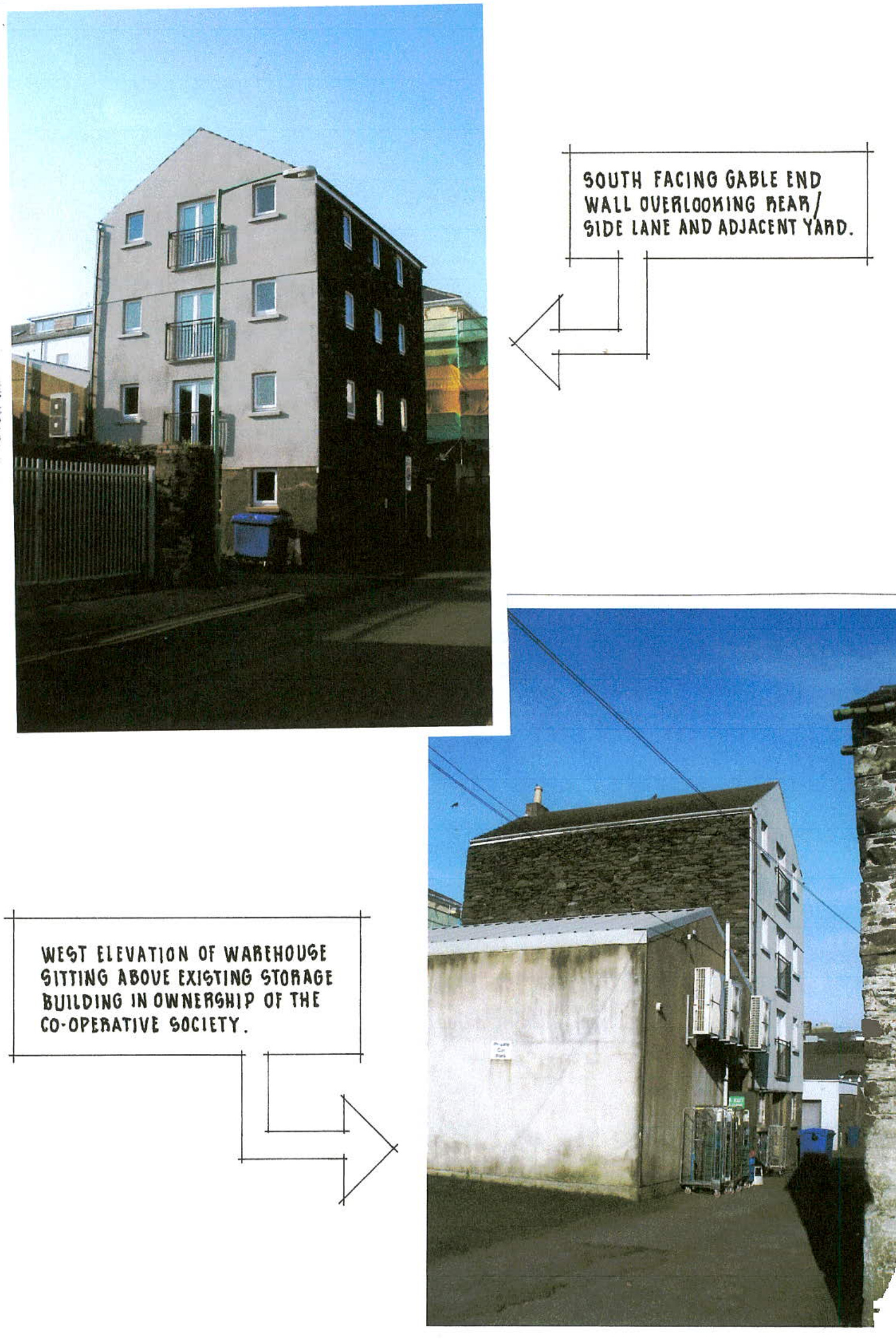
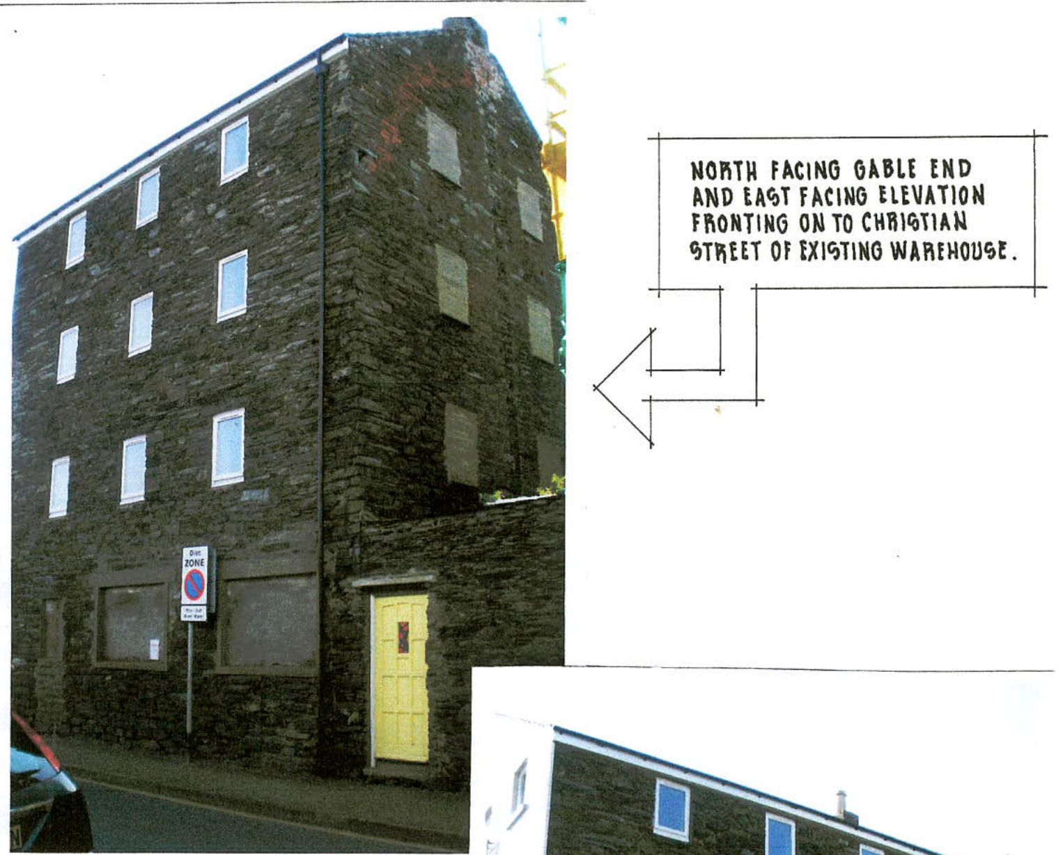
EAST FACING ELEVATION FRONTING ON TO CHRISTIAN STREET AND PART OF SOUTH FACING GABLE WALL ABUTTING MEAN / GIDE LANE.
Flood Risk - River And Tidal High Risk Flood Zones (River And Tidal)
High Risk Flood Zones (Tidal)
High Risk Flood Zones (River)
Flood Risk - Surface Water Surface Water- High Likelihood
Surface Water-Medium Likelihood
Surface Water - Low Likelihood
National Flood Maps used in Planning. These maps provide an indication of flood risk from rivers and the sea for the Isle of Man. Although they give a good indication of the areas of land at risk of flooding, they do not provide detail of the risk to individual properties.
Flood risk areas are areas around the Island which could be affected in the event of flooding from rivers and the sea.
The flood maps also take into account climate change for both river and coastal flooding
The Department of Infrastructure has developed island-wide indicative flood maps for surface water or pluvial sources.
Copyright in submitted documents remains with their authors. Request removal
View as Markdown