PLANNING STATEMENT TO SUPPORT THE REDEVELOPMENT OF BALLACALLIN FOR A SINGLE DWELLING, DALBY, PATRICK
1.0 The site and proposal
1.1 The site lies on the eastern side of the A27 coastal highway which runs from Peel to Port Erin along the western coast of the Island. The site extends to 0.4 hectares (just over an acre) which runs east from the road and then extends north to the rear of Ballacallin Bungalow, Rose Lea Cottage and part of Amberley as well as running to the south east to the rear of the former dwelling. Alongside the site is Shen Chroit Ballacallin - a separate dwelling.
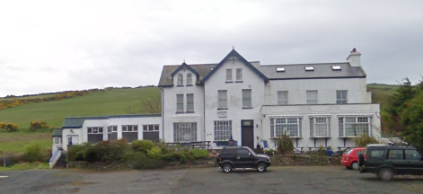
1.2 Until recently, the site accommodated the dwelling known as Ballacallin (shown below). Simon and Fenella Costain ran The Ballacallin as a small hotel from 1997 until the global financial crash in 2008 forced them to close. The property was returned to private residential use the following year.
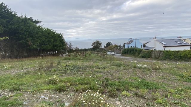
A photograph showing a large white multi-story building, identified as a former hotel, situated in a rural setting with a parking area in the foreground.A photograph showing a grassy, overgrown plot of land with trees on the left and residential houses with a sea view in the background.
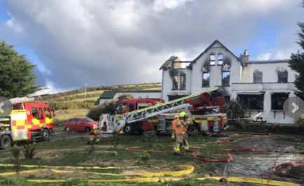
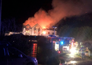
1.3 The building was significantly damaged in a fire on 9th February, 2021 and what survived was subsequently demolished. Only the adjacent cottage remains on the site with the building having been completely demolished, with approval under the Building Regulations as an Emergency Demolition of fire damaged dwelling (21/00002/BCD dated 24th February, 2021).
1.4 It was urgent that what was left of the building was made as safe as possible and the applicant considered it advisable that what remained was removed as soon as practicable and in order to reduce overall costs and avoidable journeys during the COVID lock down period, the applicant asked the demolition specialists to reduce it all to ground level rather than have them return at a later date to complete the demolition and clearance. This occurred close to the height of the COVID situation on the Island and special authority was given to demolish during lockdown as the building was a clear danger to immediate neighbours and anyone entering the site.
1.5 Proposed is the principle of the erection of a dwelling on the site to replace the former dwelling. All matters other than access are to be reserved at this stage. Access will be via the existing routes into the site and details are shown on the proposed site plan.
2.0 Planning policy
2.1 The site lies within an area designated on the Isle of Man Planning Scheme (Development Plan) Order 1982 as not for a particular purpose and within an area of an area of High Landscape or Coastal Value and Scenic Significance. The site is identified as “Hotel” in text on the plan although this is base mapping annotation rather than a land use designation in planning terms.
2.2 The 1982 Plan is the only adopted plan for Dalby although Cabinet Office are currently preparing an Area Plan for the North and West of the Island and have published the Main Consultation Document PP1 which relates to a consultation period between 16.04.21 and 25.06.21. A draft Area Plan must be published within 12 months of the end of the preliminary publicity and the document states that the Cabinet Office aims to produce a draft within 6-9 months (paragraph 13.1.2). Cabinet Office has a site assessment framework by which it determines whether sites should be designated for development. The first question it asks is whether the site falls within a settlement boundary and they provide plans which define these. Dalby is defined as follows:
A photograph showing a large white building, likely the former hotel, engulfed in smoke and fire with multiple fire engines and firefighters attending the scene.A night-time photograph showing a large building, likely the former hotel, engulfed in flames with fire trucks and emergency personnel on the scene.
2.3 Much of the curtilage of the former building as well as that of Shen Chroit Ballacallin, falls within this initial definition of the settlement boundary. The Strategic Plan identifies Dalby as a “village” where “development should maintain the existing settlement character and should be of an appropriate scale to meet local needs for housing and limited employment opportunities.”
2.4 This differs from the extent of curtilage which was shown in the approval which was granted for the conversion of the hotel to a dwelling (see Planning History) - 08/01551/C:
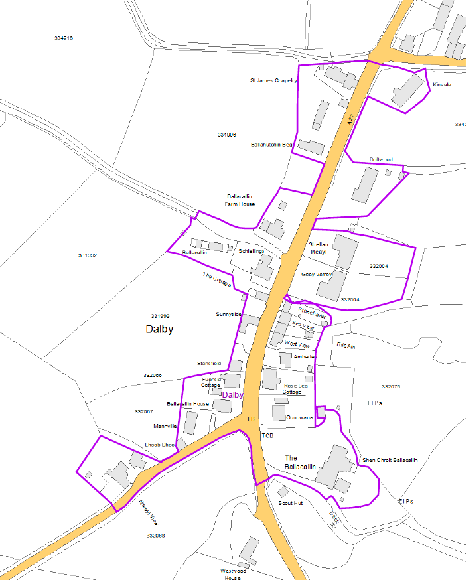
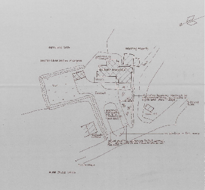
A site location map showing the application area outlined in purple lines within the village of Dalby.A rough hand-drawn site plan illustrating the property layout, existing buildings, and proposed development boundaries.
2.5 The Main Consultation Document PP1 for the Area Plan for the North and West also
includes the following on design and sustainable construction:
“7.6 Design (including Sustainable Construction) Whilst the Isle of Man Strategic Plan gives some general design principles there is a need for the Area Plan to ensure that a high level of design is achieved at the local level. Specific Proposals which support development should reflect the local character, and take account of scale and materials where appropriate. Through the use of Development Briefs, the Area Plan will aim to identify potential sites that will allow for developments to integrate well into existing settlements and have the potential to create places which people are proud of and want to spend time in. Importantly, Strategic Policy 5 of the Strategic Plan already requires planning applications to be supported by a design statement that should illustrate how new development has been designed so as to make a positive contribution to the Island’s environment.”
2.6 This coincides with the latest advice by Department of Environment, Food and Agriculture on planning applications which should have regard to sustainable construction and the need to take into account Climate Change and biodiversity in the preparation of development proposals.
2.7 The Main Consultation Document PP1 considers the latest Residential Land Availability Study which considers allocated land, planning approvals and windfalls, suggests that the housing need identified in the Strategic Plan appears to have been met up to 2026.
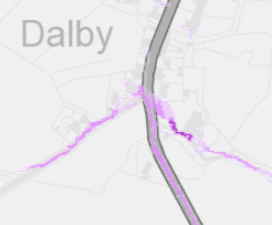
2.8 The national flood risk maps shows an area of medium and high likelihood of flood risk running through the site:
A location map showing the area around Dalby with a main road and property boundaries highlighted in purple.
2.9 There are no Registered trees or buildings on the site and it is not within a proposed or adopted Conservation Area.
2.10 The current status of the site is that it is not designated for development according to the Isle of Man Planning Scheme (Development Plan) Order 1982. There are provisions for developing undesignated land on the following bases:
• Re-use of an existing building of historic, architectural or social interest (Environment Policy 16 and Housing Policy 11 of the Strategic Plan )
• Replacing an existing building with lawful use (Housing Policies 12 and 14 of the Strategic Plan)
• Redevelopment of previously developed land (General Policy 3 of the Strategic Plan).
General Policy 3: Development will not be permitted outside of those areas which are zoned for development on the appropriate Area Plan with the exception of:…
(b) conversion of redundant rural buildings which are of architectural, historic, or social value and interest; (Housing Policy 11);
(c) previously developed land(1) which contains a significant amount of building; where the continued use is redundant; where redevelopment would reduce the impact of the current situation on the landscape or the wider environment; and where the development proposed would result in improvements to the landscape or wider environment;
(d) the replacement of existing rural dwellings; (Housing Policies 12, 13 and 14)…
Housing Policy 12: The replacement of an existing dwelling in the countryside will generally be permitted unless:
(a) the existing building has lost its residential use by abandonment; or
(b) the existing dwelling is of architectural or historic interest and is capable of renovation.
In assessing whether a property has lost its habitable status(1) by abandonment, regard will be had to the following criteria:
(i) the structural condition of the building;
(ii) the period of non-residential use(2) or non-use in excess of ten years;
(iii) evidence of intervening use; and
(iv) evidence of intention, or otherwise, to abandon.
Housing Policy 14: Where a replacement dwelling is permitted, it must not be substantially different to the existing in terms of siting and size, unless changes of siting or size would result in an overall environmental improvement; the new building should therefore generally be sited on the “footprint” of the existing, and should have a floor area(1), which is not more than 50% greater than that of the original building (floor areas should be measured externally and should not
include attic space or outbuildings). Generally, the design of the new building should be in accordance with Policies 2- 7 of the present Planning Circular 3/91, (which will be revised and issued as a Planning Policy Statement). Exceptionally, permission may be granted for buildings of innovative, modern design where this is of high quality and would not result in adverse visual impact; designs should incorporate the re-use of such stone and slate as are still in place on the site, and in general, new fabric should be finished to match the materials of the original building. Consideration may be given to proposals which result in a larger dwelling where this involves the replacement of an existing dwelling of poor form with one of more traditional character, or where, by its design or siting, there would be less visual impact.
2.11 Previously Developed Land is defined in the Strategic Plan as follows:
Previously-developed land is that which is or was occupied by a permanent structure, including the curtilage of the developed land and any associated fixed surface infrastructure.’ The definition includes defence buildings, but excludes: Land that is or has been occupied by agricultural or forestry buildings. Land that has been developed for minerals extraction or waste disposal by landfill purposes where provision for restoration has been made through development control procedures. Land in built-up areas such as parks, recreation grounds and allotments, which, although it may feature paths, pavilions and other buildings, has not been previously developed. Land that was previously-developed but where the remains of the permanent structure or fixed surface structure have blended into the landscape in the process of time (to the extent that it can reasonably be considered as part of the natural surroundings).
There is no presumption that land that is previously-developed is necessarily suitable for housing development nor that the whole of the curtilage should be developed.
3.0 Planning History of the site
3.1 The site itself was subject to a number of applications for alterations and extensions of the existing former structure. Permission was granted under 01/01398/B for the erection of four holiday cottages: this was not understood to have been implemented and nor were 88/00212/A and 88/04502/B for holiday chalets.
3.2 08/01551/C saw approval granted for the change of use of the hotel to a dwelling. This was granted on appeal following challenges by a local resident and Patrick Parish Commissioners to the approval granted by the Department. The inspector noted that the hotel was “a substantial, detached 3 storey building” (paragraph 1) and that the Ballacallin Hotel as a single planning unit where the restaurant and bar were ancillary to the primary use of the property as an hotel and Community Policy 3 which protects some community
facilities, does not provide for the protection of the restaurant and bar facilities and the hotel was not a community use. This permission was implemented.
4.0 Justification for the erection of a dwelling on the site
4.1 Currently there is no building on site and the site is not designated for development on the adopted Development Plan. It is considered relevant that the building was significantly fire damaged and that what remained after the fire was put out, was removed in the interests of safety. It would have been possible, however inadvisable in a safety or structural sense, to retain some of the structure that remained after the fire had been put out, leaving behind the shell of part of the original building. This would not have been pleasant for those living around the site nor passing through the village and indeed, would have been a potential liability for the owner of the site from a danger point of view. However this would have been likely to result in what remained constituting “previously developed land” for the purposes of General Policy 3 and with a more simple argument for replacing it with a new building. It would be unfortunate if the applicant were to be penalised for acting responsibly following a traumatic event at their property. The inspector considering 08/01551/C for the conversion considered that the deterioration of the fabric of the building, should planning approval not have been granted, would “benefit nobody” as would have been the case if the remains of the fire damaged building had been retained and not completely demolished.
4.2 It is relevant that the initial information emerging in respect of the Area Plan for the North and West appears to identify the site as within the settlement boundary and indeed the former Ballacallin, sitting between the road and Shen Chroit Ballacallin, was visually and functionally part of the hamlet.
4.3 Development could not, technically be considered compliant with Housing Policy 14 as there is currently no house to replace and indeed it was not the owner’s intention to replace the building as they were renovating and had converted the former building to a dwelling in accordance with their planning approval. However, it is considered relevant that the building was only recently demolished and through no fault of the applicant and had they not acted responsibly and removed all of the remaining structure following the fire, the development may well have been considered to comply with either Housing Policy 14 or General Policy 3, or both.
4.3 Previously developed land1 is referred to in General Policy 3. The definition is perhaps ambiguous in that it refers to “land which is or was occupied by a permanent structure” [my underlining] and indeed, prior to the fire and the demolition of the remains of the building, what existed was a permanent structure.
4.4 The former building retained some interest due to its age and function as an hotel although that use was no longer apparent following the approval to convert the building to a dwelling, the hotel having closed in 2007. There is no reference in the inspector’s report on 08/01551/C to any particular architectural, social or historic interest which would presume against the replacement of the former building on these grounds (Housing Policy 12). To have enabled the former building to be energy and thermally efficient, this would have required considerable cost with results far short of what could be achieved with a completely
new building which will have to comply with much higher levels of thermal and energy efficiency than would be the case with renovation of the former existing building. To erect a replacement building which achieves these higher standards will go towards the Department’s and Government’s objectives, goals and policies to combat Climate Change and promote sustainable construction.
4.5 If permission is granted for the erection of a dwelling on this site as a replacement for the former dwelling on it, this would be thermally and energy efficient, as is required by current Building Regulations and far more so than was the former building or ever could be. A new dwelling could benefit from modern methods of construction and its design adapted to acknowledge the position and context of the site.
4.6 The Strategic Plan welcomes good use of previously developed land and unused land and buildings: Strategic Policy 1: Development should make the best use of resources by:
(a) optimising the use of previously developed land, redundant buildings, unused and under-used land and buildings, and reusing scarce indigenous building materials;
(b) ensuring efficient use of sites, taking into account the needs for access, landscaping, open space(1) and amenity standards; and
(c) being located so as to utilise existing and planned infrastructure, facilities and services.
4.7 The recent decision for the replacement of the adjacent scout hut is relevant (21/00526/ A): this was refused for the reason that:
The erection of a dwelling on the proposed site which is located within an area not designated for development would be contrary to established planning policies aimed at protecting the Manx countryside for its own sake. Whilst there is potential that the proposal could fall under General Policy 3 (c), previously developed land, a proposed dwelling within this area/size would be larger than the existing scout hut which means there would be an increased visual impact, especially when taking into context the removal of trees which shield the existing site, all of which would be contrary to General Policy 3 and Environment Policy 1 of the Isle of Man Strategic Plan 2016.
4.8 Any decision on the current application site should be consistent with that although there are significant differences between the two sites: the Area Plan settlement boundary clearly distinguishes between the curtilage of the Ballacallin Hotel and Shen Chroit Ballacallin alongside from the scout hut which is outside the settlement boundary. In addition, planning approval was granted for the conversion of the former hotel building to a dwelling which had been implemented at the time of the fire.
Flood risk
4.9 The national flood risk maps show part of the site being at risk of surface water flooding. In the applicant’s 25 year ownership of the site, they have no experience of flooding occurring on the site although in any application for the reserved matters will deal with this as it is not in the applicant’s interests to invest in the development of this site if it will flood in the future. It is their view that increasing the height of the existing hedging in this part of the site will assist with flood mitigation and also note that there is no sign of any issues in the adjacent lane with drainage ditch after recent heavy rain, which is the primary risk area in their view. Impact on the living conditions of those in neighbouring property
4.10 There is an opportunity to erect any new dwelling further from the boundary of Shen Chroit Ballacallin, improving the outlook and privacy of that property. The position and design of the new dwelling will also acknowledge the amenities of the other adjacent dwellings in accordance with the Residential Design Guidance. Design
4.11 The design of the new dwelling will be determined at the reserved matters stage but should take account of the context of the site as well as the need to meet modern standards of construction and thermal efficiency and where possible, incorporating renewable energy and enhancing biodiversity (eg the incorporation of bird, bee and bat habitat within the building and the site. There will be no net loss of biodiversity as a result of the proposed development: rather, the redevelopment of the site will facilitate new planting and habitat creation which would not be likely if planning approval is not granted.
5.0 Conclusion
5.1 It is our view that the site should be considered as eligible for redevelopment as there was, until recently occupied by a sizeable building whose demolition was brought about through no fault of the applicant who cleared the site in the interests of safety and amenity and as an emergency.
5.2 The site is currently identified as lying within the settlement boundary and has existing buildings on all four sides - Shen Chroit Ballacallin, the scout hut, Ballacallin Cottage on the same side of the road and Ballacallin House opposite. The new house will utilise all of the services and access that served the previous dwelling on the site and there will be considerable opportunities for improving the thermal effectiveness of the building on the site and improving the biodiversity value of the site.
References:
1Previously Developed Land Previously-developed land is that which is or was occupied by a permanent structure, including the curtilage of the developed land and any associated fixed surface infrastructure.’ The definition includes defence buildings, but excludes: Land that is or has been occupied by agricultural or forestry buildings. Land that has been developed for minerals extraction or waste disposal by landfill purposes where provision for restoration has been made through development control procedures. Land in built-up areas such as parks, recreation grounds and allotments, which, although it may feature paths, pavilions and other buildings, has not been previously developed. Land that was previously-developed but where the remains of the permanent structure or fixed surface structure have blended into the landscape in the process of time (to the extent that it can reasonably be considered as part of the natural surroundings).
There is no presumption that land that is previously-developed is necessarily suitable for housing development nor that the whole of the curtilage should be developed.
Copyright in submitted documents remains with their authors. Request removal