Loading document...
On behalf of Allprop Ltd Project Ref: 28538 | Rev: AA | Date: June 2015 Office Address: 2nd Floor, 160 West George Street, Glasgow G2 2HG T: +44 (0)141 352 2360 E: [email protected]
| Revision | Date | Description | Prepared | Reviewed | Approved |
|---|---|---|---|---|---|
Project Name: Howstroke Development Project Project Ref: 28535 Report Title: Planning, Design & Access Statement Date: June 2015
| Name | Position | Signature | Date | |
|---|---|---|---|---|
| Prepared by: | Lauren Park | Planning Consultant | Lauren Park | 28/05/2015 |
| Reviewed by: | Mark Johnston | Senior Associate | MJ | 03/06/2015 |
| Approved by: | Nick Skelton | LLP Director | NS | 03/06/2015 |
| For and on behalf of Peter Brett Associates LLP |
Peter Brett Associates LLP disclaims any responsibility to the Client and others in respect of any matters outside the scope of this report. This report has been prepared with reasonable skill, care and diligence within the terms of the Contract with the Client and generally in accordance with the appropriate ACE Agreement and taking account of the manpower, resources, investigations and testing devoted to it by agreement with the Client. This report is confidential to the Client and Peter Brett Associates LLP accepts no responsibility of whatsoever nature to third parties to whom this report or any part thereof is made known. Any such party relies upon the report at their own risk.
1 Introduction ..... 6 1.2 Taking a sensitive approach to development ..... 6 1.3 Document Structure ..... 7 2 Site Context ..... 9 2.1 The Site ..... 9 2.2 Surroundings ..... 10 2.3 Visual Context ..... 12 2.4 Planning History ..... 14 3 Consideration of Planning Policy ..... 15 3.2 Isle of Man Strategic Plan, 2007 ..... 15 3.3 Isle of Man Strategic Plan 2015 (Draft) ..... 15 3.4 Onchan Local Plan 2000 ..... 16 3.5 Landscape Guidance ..... 17 4 Development proposal ..... 19 4.2 Siting Parameters ..... 19 4.3 Principles of Height, Scale and Massing ..... 19 Principles of ..... 21 4.4 Design ..... 21 4.5 Illustrative Proposals ..... 24 5 Access ..... 25 5.2 Key Policy Documents ..... 25 5.3 Current Site Access ..... 25 5.4 Proposed New Access ..... 25 5.5 Traffic Generation ..... 25 6 Drainage, Water Supply \& Utilities ..... 26 6.2 Electricity ..... 26 6.3 Water ..... 26 6.4 Foul Water Drainage ..... 26 6.5 Surface Water Drainage ..... 26 6.6 Telecommunications ..... 26 6.7 Gas ..... 26 6.8 Conclusion ..... 26 7 Ecology ..... 27 7.2 Habitat ..... 27 7.3 Protected Species of plants ..... 27 7.4 Protected species of animals ..... 27 7.5 Summary ..... 27 8 Conclusions ..... 28
Planning Statement Howstrake Development Project Figures Figure 2.1 - PBA photographs of the site, 2014 ..... 9 Figure2.2 - Groudle Cottages and the view towards Howstrake, PBA 2014 ..... 11 Figure 2.3 - Viewpoint location plan ..... 12 Figure 2.4 - View from Sea Lion Rocks Tea Room and Visitor Centre ..... 12 Figure 2.5 - View from Groudle Railway ..... 12 Figure 2.6 - View from Ballamenagh Road ..... 13 Figure 2.7 - View from Ballamenagh Road ..... 13 Figure 4.1 - Viewpoint location plan ..... 18 Figure 4.1 - Viewpoint location plan ..... 18 Figure 5.1 - Howstrake holiday camp. Previous development on site. Photo taken by www.oldukphotos.com ..... 20 Figure 5.2 - Existing development - view from the Groudle Railway line ..... 20 Figure 5.3 - The Brow of the Hill: Southern House. Photo by Michael Nicholson ..... 22 Figure 5.4: Stormy Castle. Photo by Charles Hosea ..... 23 Figure 5.5 - House Boz. Photo by Barend Roberts \& David Ross ..... 23 Figure 5.6 - Indicative section through the proposed development showing possible development configuration ..... 24 Figure 5.7 - Illustrative view of the proposed development site showing possible development configuration ..... 24 Tables Table 3.1 - Landscape Considerations as described in Draft PPS 2/09 ..... 17
1.1.1 Howstrake, home of the first holiday camp in the British Isles, has lain vacant since its last visitors left in 1973. The c. 11 ha of land within our client's ownership is located on the coast south of Groudle Glen, and adjacent to King Edward Road and the Manx Electric Railway. The site area is 3.6 ha . While there has been some natural re-vegetation (mainly of gorse), the main accommodation blocks, other buildings, former swimming pools, stairways and path networks remain prominent but derelict and in a poor state of repair. The site does not have public access and there are no rights of way on the site. The remaining buildings on site are heavily vandalised. 1.1.2 Without investment to tackle the condition of the site and access to it, Howstrake will deteriorate further, continuing to blight the landscape while making no positive contribution to the Isle of Man economy. However, development of some kind will be required to generate the value needed to realise site improvement. 1.1.3 Despite various redevelopment proposals since Howstrake's closure none have been taken forward (see para 2.1.1). Previous proposals have generally failed to recognise the site's sensitive relationship to surrounding areas, focussing more on its capacity to accommodate relatively high density residential or holiday accommodation. The most recent application, submitted in 2009, also lacked any detailed information showing how the site would be accessed and how utilities would be provided. 1.1.4 The present owner now wishes to bring the site back into use and a different approach has been adopted. This statement is informed by a review of existing policy, the site history, site visits and technical assessments; and initial discussions with various bodies including Manx National Heritage and the Department of Infrastructure. 1.1.5 The rationale for development at Howstrake is straightforward: turning a derelict and unused site which detracts from the Isle of Man's appeal into an asset which can make a positive contribution to, landscape and other objectives.
1.2.1 Recognising Howstrake's sensitivity, the site's landscape and natural heritage features and its relationship with nearby settlements have been taken into account before considering where and what scale of development might be brought forward. 1.2.2 Preparation of this application has involved a combination of comprehensive site analysis and consideration of technical challenges with a series of focussed and appropriate consultations. It has included:
On the basis of the discussions shown above, the following core principles for improving the site were identified including:
Initial analysis indicated that development embracing these principles would be deliverable and viable.
The following sections of this Planning, design and access statement are structured as follows:
The planning application is supported by the following drawings, and also by the various reports detailed in paragraph 1.2.2 above.
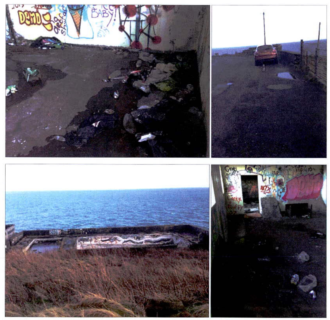
2.1.1 The former Howstrake Holiday Camp site is identified in the Onchan Local Plan 2000, the current Local Plan, as being in a "state of dereliction" and "in dire need of restoration". It notes that the site can be clearly seen from both King Edward Road and the southern end of Ballameanagh Road. The site is described as being on "an exposed and prominent coastal site". 2.1.2 The site is steep but layered with a legacy of platforms and access ways that lend themselves to natural appreciation of the views and wider links. 2.1.3 Measures have been taken to prevent general public access to the site. Nevertheless, the site continues to be regularly entered and used by members of the public, resulting in the accelerated deterioration of the buildings and other detrimental impacts on the amenity of the site.
Figure 2.1 - PBA photographs of the site, 2014
2.1.4 The site is occupied by deteriorating, highly visible permanent structures which have not blended into the landscape. The buildings, former swimming pool and other features (including stairways) have been redundant since 1973. All are in poor condition and are visible from the pavement and railway line on King Edward Road. 2.1.5 The nearest Rights of Way are the Baldromma to Groudle path (ref 186A), and Groudle to Beach (Ref 429), both located to the north of the site.
2.2.1 Groudle Glen lies immediately to the north of Howstrake. Following planning permissions in 1994 and 1992, a combination of holiday chalets, studio apartments - 38 units in total - were developed at Groudle Glen. Eleven of the units subsequently received approval for conversion to residential use. 2.2.2 The area to the south of the site is steep cliff and there are no neighbours. The nearest neighbours to the south are approximately 600 m away from the tram stop at the existing entrance to the site. To the west of the site is King Edward Road, the railway line and King Edward Bay Golf Club. The steep slope down from the golf course to the site means that the site is not visible from the course.
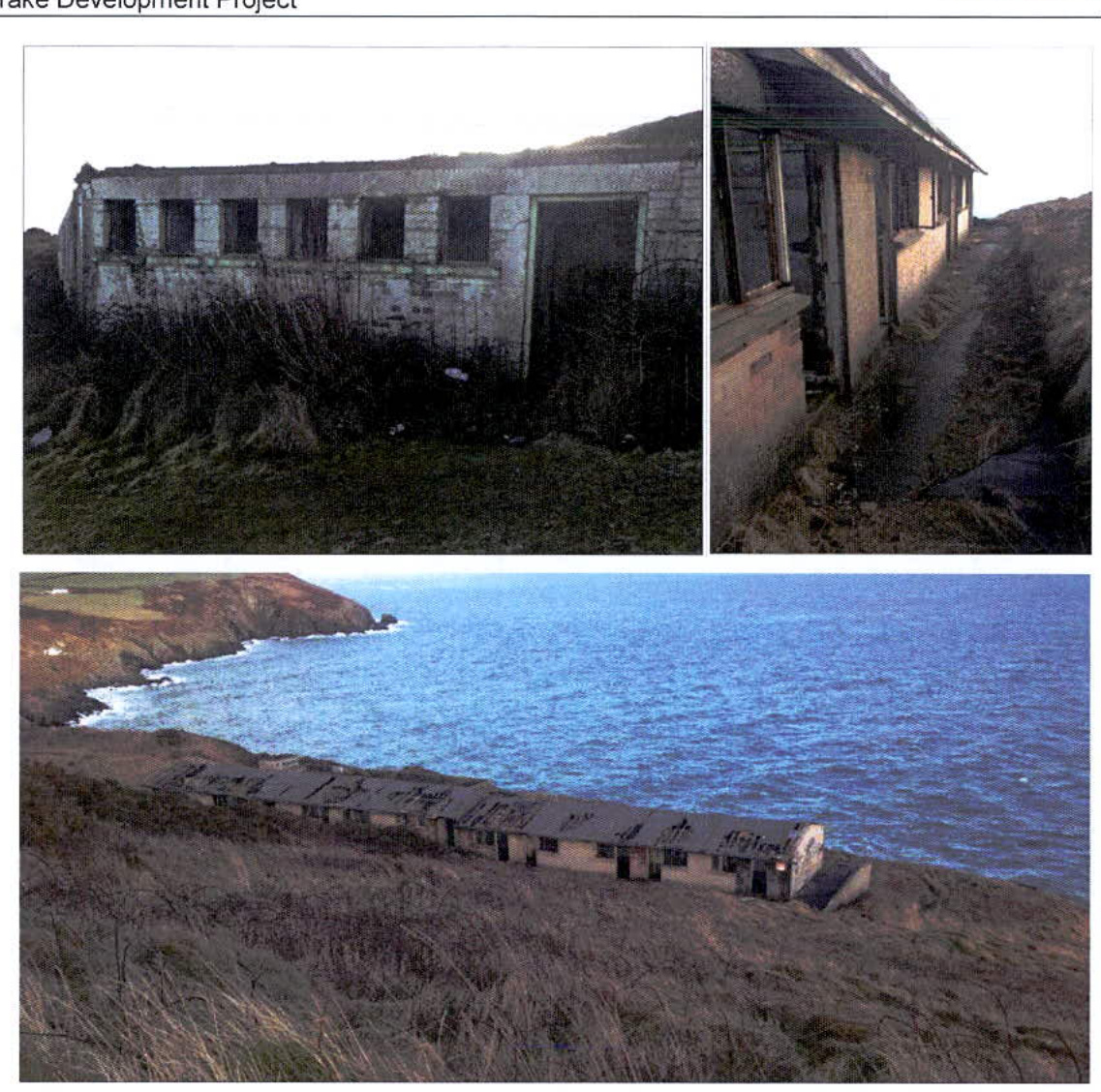
Figure 2.2 – Groudie Cottages and the view towards Howstrake, PBA 2014
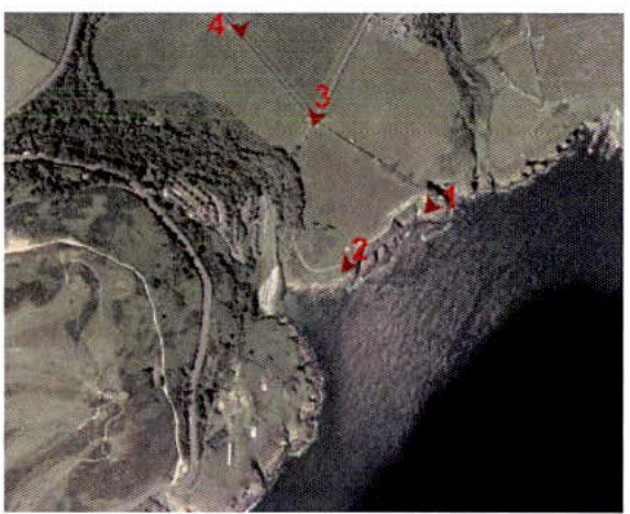
2.3.1 The Onchan Local Plan (2000) notes that the Howstrake site "remains unimproved and visually intrusive". The former holiday camp buildings which are heavily vandalised remain visible from King Edward Road. The following series of view points have been selected following careful consideration of the visual envelope of the site. The topography of the coastline is such that vantage points are restricted to views from the North East, as illustrated in figure 4.1.
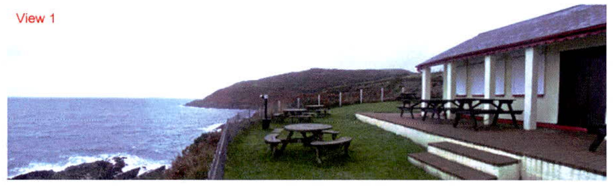
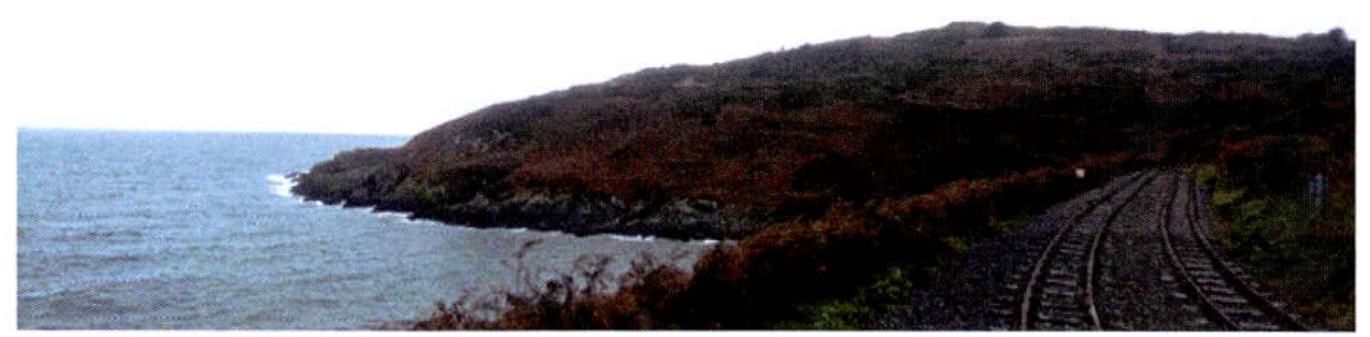
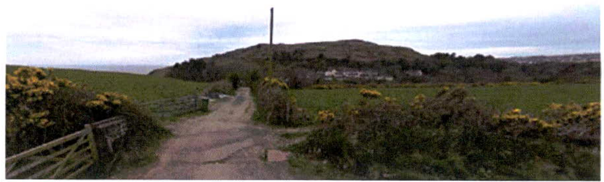
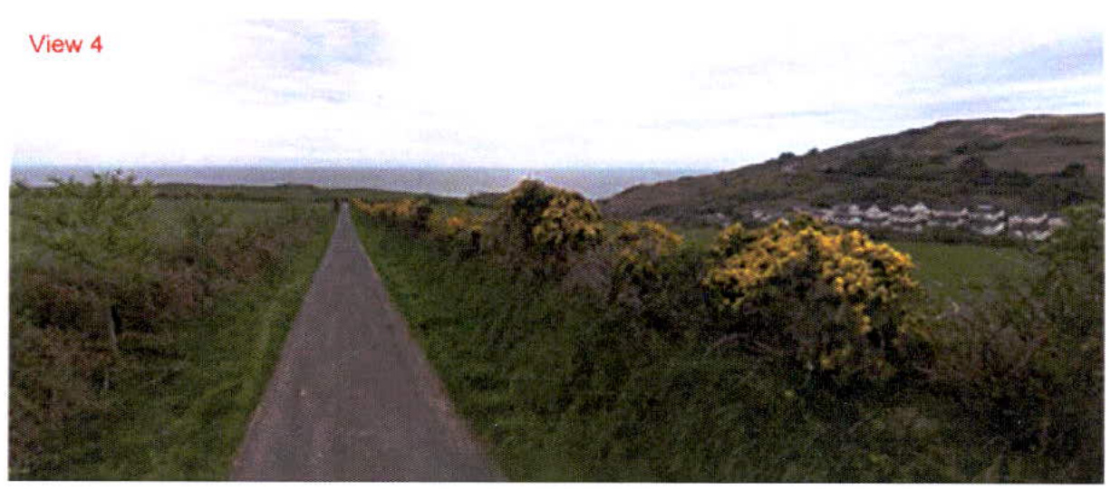
Figure 2.3 - Viewpoint location plan 2.3.2 View 1 is taken from the Sea Lion Rocks Tea Room and Visitor Centre looking back towards the Howstrake site. This is a key coastal view. The side of the existing holiday block building is visible from this viewpoint although the steep slope from Groudle Glen up to the site means that it is not possible to view any other structures on the site. 2.3.3 View 2 is taken from the end of Groudle Railway towards the Howstrake site. 2.3.4 Views 3 and 4 are taken from different points on Ballamenagh Road looking towards Groudle Cottages and the Howstrake site. The Groudle Cottages are the main feature in this view and the development on the Howstrake site is predominantly hidden by the steep slope and vegetation.
Figure 2.4 - View from Sea Lion Rocks Tea Room and Visitor Centre
Figure 2.5 - View from Groudle Railway
View 2
Figure 2.6 - View from Ballamenagh Road
View 3
Figure 2.7 - View from Ballamenagh Road
2.3.5 The above series of views shows the sensitivity of this coastal location and demonstrates the requirement for carefully considered development and landscape. The site is visible from public vantage points to the North East and requires sensitive treatment in order to preserve the integrity of these views. 2.3.6 In the context of General Policy 3, discussed in section 3.2 below, the proposals will substantially enhance these views by removing the redundant, unsightly remnants of the Howstrake Holiday Camp and complying with the specific exemption provided in the Strategic Plan for the construction of buildings outside the zoned areas.
There have been a series of planning applications on the Howstrake site since 1986 with the most recent in 2009:
With the exception of the most recent application which we understand did not have sufficient supporting information, previous applications have sought high density development of a scale considered inappropriate to this location. The current proposals have been designed to respond these concerns and permission is now sought for a single dwelling and relevant supporting studies are included to provide the Department with the required information.
3.1.1 This chapter examines existing planning policy and guidance pertinent to the development of this site. It summaries the policy framework within which the application will be determined and demonstrates that the development is compliant and can be positively considered by the Department.
3.2.1 The Isle of Man Strategic Plan was produced by the Department of Local Government and the Environment in 2007 to guide development. While strategic in nature, several of its spatial policies are relevant to Howstrake. Most notably, as Howstrake is previously developed land, General Policy 3 offers clear opportunity for the future;
Development will not be permitted outside of those areas which are zoned for development on the appropriate Area Plan with the exception of: (c) previously developed land which contains a significant amount of building; where the continued use is redundant; where redevelopment would reduce the impact of the current situation on the landscape or the wider environment; and where the development proposed would result in improvements to the landscape or wider environment; 3.2.2 The proposed development of Howstrake is clearly compliant with the above policy:
3.2.3 In this context, the development proposals can be positively considered by the Department. They will deliver significant gain in landscape and visual terms and will secure a positive future for this long neglected part of the Island.
3.3.1 We note that a new version of the Isle of Man Strategic Plan is now available in draft form and is scheduled for adoption later in 2015. We have considered the content of the Draft and note that it does not make any material changes to the policies of the 2007 Strategic Plan that would affect this planning application. Importantly the text of general Policy 3 as quoted above remains unchanged in the Draft. It is further noted that until the review of the Isle of Man Strategic Plan 2015 is complete the Isle of Man Strategic Plan 2007 remains in force.
Copyright in submitted documents remains with their authors. Request removal
View as Markdown