Planning Statement For The Conversion Of Existing Stables To Tourist Accommodation, Rosehill Farm, Richmond Hill, Braddan Im4 1Jg
1.0 Introduction
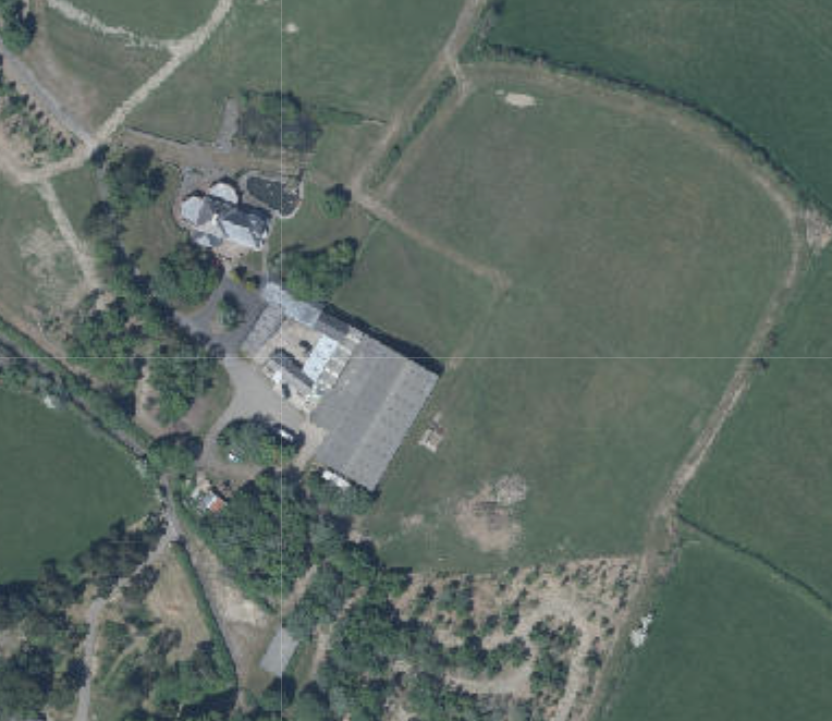
1.1 Rosehill Farm is a farm extending to 18.5 acres situated at the top of Richmond Hill and lying to the south thereof. The entrance sits between Rosehill Lodge and the entrance to Beaconsfield Farm to the south west.
1.2 The land accommodates a range of buildings including the dwelling - Rosehill Farm house which is currently in the process of being extended (see Planning History), a group of outbuildings which incorporate a large, modern indoor arena, a two storey building used as residential accommodation and most recently has planning approval for additional use as tourist accommodation, and a single storey stable building. The two storey residential/tourist accommodation sits between the indoor arena and the single storey stables.
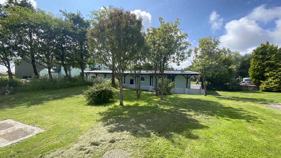
View of stables from the north
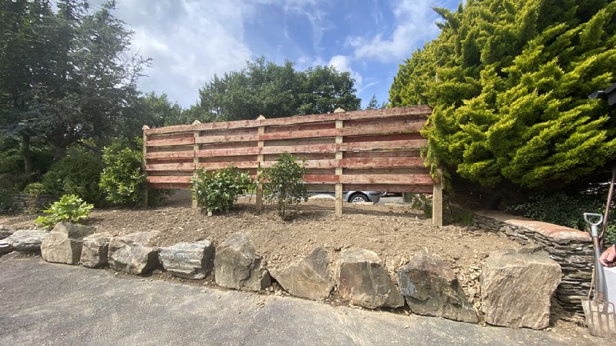
1.3 All of the buildings on site are in a relatively compact group although there is fencing and landscaping between the house and the outbuildings at the closest point.
Section of fencing and planting between the main dwelling and the western side of the stables
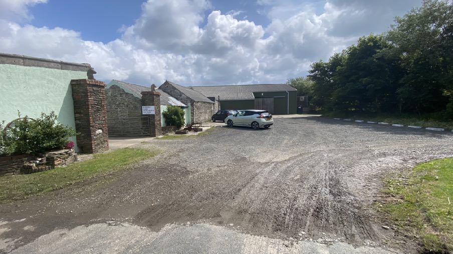
1.4 There is a yard beside all of the outbuildings which provides parking. This area isapproximately 14m by 16m with additional parking spaces at the side of the arena.
View of the yard parking area as viewed from the north west
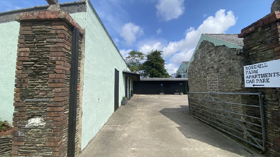
1.5 There is also a hard surfaced yard at the rear of the two storey residential/touristaccommodation and the single storey stables which accommodates additional car parking.
A photograph showing a paved access driveway and car park entrance between a rendered building and a stone wall, with a sign indicating 'Rosehill Farm Apartments Car Park'.
Entrance to the courtyard between the residential accommodation and stables
2.0 Planning Policy
2.1 Planning policy takes a number of forms: land is designated for a particular purpose, or not, on an adopted Area or Local Plan (or where there is neither, Isle of Man Planning Scheme (Development Plan) Order 1982). Above this, there is the Isle of Man Strategic Plan 2016 which is not geographic but provides over-arching strategic policies which apply across the Island. Area Plans should be in general conformity with the Strategic Plan but where there is any contradiction of conflict, whichever was adopted later would prevail (paragraph
1.4.4).
2.2 Consideration can also be given in the determination of any planning application, to Planning Policy Statements, Planning Circulars, National Policy Directives (there is none as yet) or other statements of planning policy as well as other Government policies. Planning is a balance of all of these considerations as well as anything else which could be considered a material consideration.
Area Plan for the East
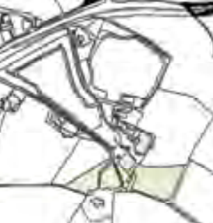
2.3 The site lies within an area designated on the Area Plan for the East as not for a particular purpose. Essentially this means that the site is not designated for development and is considered to be part of the countryside.
2.4 On the Environmental Constraints Map 1a there are two fields to the south of the building group which are identified as an area of predominantly trees or woodland.
A hand-drawn style site plan showing building outlines, property boundaries, and a highlighted plot area.
2.5 High voltage cables and lines are shown on the Infrastructure Constraints Map 1b, to the south of the site.
2.6 When planning policy was first introduced in a map form, the Isle of Man Planning Scheme (Development Plan) Order 1982 contained areas of an area of High Landscape or Coastal Value and Scenic Significance in which this site sat. These have been replaced in the Area Plans by the designations and guidance in the Landscape Character Assessment 2008. Here, the site appears to lie on the boundary of two areas of the same Landscape Character
Incised Inland Slopes (D10 Braaid and D13 Santon). The advice in the Area Plan for the East for these two areas is as follows and the full text from the original document is set out in Appendix Two:
D10 Landscape Strategy
Conserve and enhance: a) the character, quality and distinctiveness of the area, with its open large pastoral fields; b) its Manx hedges; c) its scattered farm houses fringed by trees; d) its sunken and enclosed rural road network and its numerous archaeological features.
Key Views Extensive uninterrupted panoramic views from higher points over large open fields and Greeba Valley and the northern Uplands and eastwards to the built-up edge of Douglas. Some glimpsed views over fields from most sections of roads, which are enclosed by high grassed Manx hedgerows for the most part.
D13 Landscape Strategy Conserve and enhance:
a) the character, quality and distinctiveness of the area, with its wooded valley bottoms and wooded horizons;
b) its scattered settlement pattern;
c) its Victorian garden and the railway.
Key Views Open and expansive views from the higher areas along the rugged coast in the east and inland towards the upland areas over Braaid. Incinerator chimney forms a notable landmark in the immediate area. Glimpsed views framed by vegetation in the valley bottoms and along the main roads where they follow the wooded valley bottoms. Views in the northern part of the area up to the Transmitting Masts on top of Douglas Head hill top. Views from Isle of Man Steam Railway
2.7 The site is not shown on the national flood risk maps as in at risk of flooding.
2.8 The site is not within a Conservation Area and does not contain any Registered Buildings or Registered trees.
2.9 The Strategic Plan presumes against development in undesignated areas and generally directs new building towards existing settlements. There are exceptions to this (General Policy 3) including the conversion of existing rural buildings to other uses (Environment Policy 16 and Housing Policy 11) although amongst the criteria is that the building shall be considered of historic, architectural or social interest.
2.13 Development which would adversely affect ecology is presumed against (Environment Policies 4 and 7) and development is now expected to result in at least no nett loss of biodiversity but ideally a biodiversity nett gain (Residential Design Guide). Development which results in the loss of the highest grade agricultural land is presumed against (Environment Policy 14). This appears to be Class 3.
2.14 Development is now also expected to demonstrate how it addresses Climate Change (Residential Design Guide).
2.15 Development must have an acceptable impact on highway safety including the provision of adequate car parking (Transport Policies 4 and 7).
2.16 Tourism-related development is generally welcomed although only where it complies with the other policies in the Strategic Plan so there isn’t anything which would support new development in the countryside. However, the Government’s Tourism Strategy and the Department for Enterprise’s Non Serviced Accommodation Study (sent separately) are material considerations which have some weight in the consideration process. There have
been applications approved for tourism development in areas not designated for development and some of these are listed below in Planning History.
3.0 Planning history and relevant applications
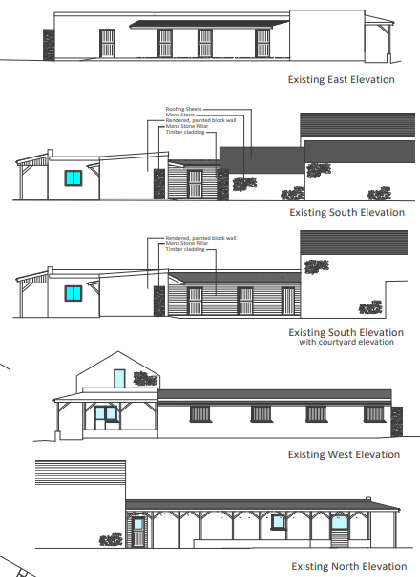
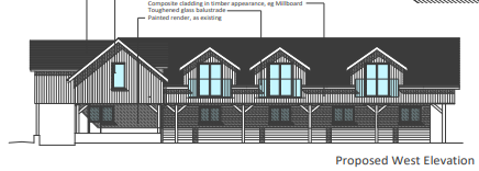
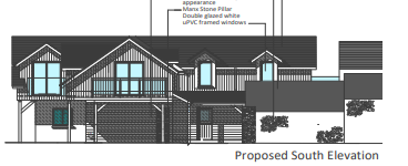
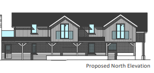
The image presents a series of architectural elevation drawings labeled East, South, West, and North, showing the existing building structure and material details.Architectural elevation drawing showing the proposed west elevation of a building conversion with dormer windows and material annotations.An architectural elevation drawing labeled 'Proposed South Elevation' showing the exterior design of a converted stable building with specific material annotations.The image shows a technical architectural drawing labeled 'Proposed North Elevation', depicting the front facade of a two-story building with a mix of brick and timber cladding.
3.1 The site has been the subject of a number of applications for agricultural buildings (99/01942/B, 00/02325/B), for alterations and extensions to the dwelling and re-siting of the entrance (91/00271/B), extension to the dwelling 97/00934/B, 98/00562/B, 02/01602/ B), 11/00968/B and 18/00886/B.
3.2 Permission was refused for the principle of the conversion of farm buildings to a dwelling
88/00413/A, 95/00249/B, 95/00862/B but permitted along with extensions, under 83/00901/B. Due to their age, the details of the proposals and the reasons for refusal are not available online.
3.3 23/00386/C was approved recently for temporary change of use of site for a family festival with associated day parking, camping and motorhomes for 30th June to 2nd July 2023 and 28th to 30th June 2024 and 27th to 29th June 2025. Fields 525114, 525121 and 524105.
3.4 Planning approval was refused for the conversion and extension of an existing stable building to tourism units: 22/01500/B:
3.5 The
reasons for refusal were as follows:
1. The site is not designated for development, is not within any settlement boundary and is not a building of historic, architectural or social interest warranting it an exception to development in the countryside contrary to Strategic Policy 2, Spatial Policy 5, Environment Policy 1, General Policy 3(b), Housing Policy 11 and Environment Policy 16 of the Isle of Man Strategic Plan 2016.
2. The site contains some previously developed land, however its proposed redevelopment would result in an increased impact on the environment and landscape beyond the current situation contrary to General Policy 3(c) of the Isle of Man Strategic Plan 2016.
3. The proposal by reason of its increased level of activity, upwards height increased and proximity to neighbouring property within the courtyard would result in an adverse overbearing and overlooking impact harming the adjacent properties privacy, overall outlook, living conditions and general amenity contrary to General Policy 2 (b, c, g) of the Isle of Man Strategic Plan 2016.
4. By reason of the increased level of activity at the site as a result of the proposed tourist units and their associated traffic movements, it is not considered that sufficient information has been provided to demonstrate safe access and egress onto and from the main arterial route which is three lanes wide and subject to high traffic speeds and passing vehicles without resulting in any highway safety issues or highway network and safe flow of traffic issues contrary to General Policy 2 (h and i) and Transport Policy 4 of the Isle of Man Strategic Plan 2016.
3.6 Notwithstanding reason 4, no objection was received from the Highway Services Division of Department for Infrastructure who commented that “HDC finds it to have no significant negative impact upon highway safety, network functionality and /or parking. The Applicant is advised to consider secure and enclosed bicycle storage and installation of an electric vehicle charging point.”
3.6 The two storey apartments were approved for additional use as tourist accommodation under 23/00048/C.
Other sites
3.7 In other parts of the Island, planning approval has been sought for tourist related development. In East Baldwin in Ballawyllin Farm, planning approval was granted for two free standing cabins to complement the existing bed and breakfast and complimentary therapy facility operated at that site as well as approval that was granted for the additional use of an existing detached cottage within the grounds, as tourist accommodation (16/00314/B and 13/00842/C).
3.8 A larger scale tourist development was approved at Knockaloe Beg Farm in Patrick comprising tourist units formed from existing outbuildings with a cafe and yurts in the field to the rear (20/00488/B, 16/00212/C, 14/00460/B, 12/00083/C, 06/02242/B, 05/92183/B).
3.9 Camp sites have also been approved on existing farms at Silly Moos in Lezayre (18/00010/B), Glenlough Farm (21/00349/B, 12/00057/B, 12/00052/B, 11/00549/B), Glendown Farm in Port St. Mary/Port Erin (17/01186/B, 17/00620/B, 14/00800/B, 03/00806/ B) and Ballamoar Farm in Ballaugh (16/00549/B, 16/00545/B and 12/00136/B)
3.10 Perhaps the largest scale recent development approved was at Port Erin (20/00496/B and 21/01009/B). This was for 30 glamping pods and cabins, tented and motorhome camping and a welcome centre.
3.11 A larger development in the north of the Island was withdrawn prior to it being considered in 2018 (17/00956/B). This was for 55 holiday lodges with associated facilities and infrastructure.
3.12 Permission was recently granted to the conversion of a dwelling to three tourist units at Broogh Fort, Santon (22/01064/B) where the inspector refers to the Government Tourism Strategy and the employment benefit of that proposal.
4.0 The proposal
4.1 Proposed is the conversion of the existing stables to tourist accommodation in the form of four units. This application seeks to address the reasons for refusal and concerns raised in the previous application referred to at 3.4 above. The scheme has been amended to remove any upward extension of the building or significant change thereto.
4.2 The scheme will apply composite cladding in Antique Oak colour, to the outside of the stables so that the presently rendered walling will be clad and the existing door openings and windows are to be retained other than one central door in the southern elevation facing into the courtyard is to be widened and new doors are to be inserted into the northern elevation. These new doors will lead onto a small terrace adjacent to a lawned recreation area which is presently contiguous with the lawned garden of the main house. The two units on the western side of the courtyard will see the existing windows changed to doors which will lead out onto individual terraces which sit surrounded by small wildflower meadows.
4.3 The units will have floor areas of 29.8 sq m, 28.75 sq m, 29 sq m and 27.5 sq m which will accommodate up to two persons each under the Housing Standards Regulations 2017.
4.4 Parking for the new accommodation will be within the external yard. Access to the units will share that serving the rest of the site.
4.5 The landscaping will be created from local species and types of vegetation which support pollinators. The area to the north east is established trees with four New Zealand broadleaf, two cherry laurels, four red alder, and three black alder, five whitebeam, and a Russian spiraea. The ground area is 40% wildflower. The Wildflowers were from Boston Seeds, and each year we harvest the seeds to create new areas. Established planting (circa 25 yrs) includes Atlas cedar & sycamore, two Lawson cypresss, a bay laurel and two cherry laurel (transplanted), three common box bushes, three rhododendrons, four scaly male ferns, an Eastern red cedar, a paper plant, spreading cotoneaster, red claws, a buddleia, and Iberian meadowsweet. The applicants have erected a screen fence and transplanted creeping flowering quince, that will quickly envelop the fence (see above photograph).
5.0 Planning assessment
5.1 There is a basic presumption against development here, as stated in the Strategic Plan (SP) and Area Plan for the South (APS), in particular General Policy 3 of the SP with the protection of the countryside from harmful development being provided in Environment Policy 1 and the Landscape Character Assessment and related proposals in the AP.
4.2 However, it is clear from the planning applications cited above, that exceptions for tourism related development can and are made. The Tourism Strategy makes it clear that the type of new tourism development that is needed to promote the Island as a desirable tourist destination is based upon unique design, quality accommodation, being associated with and promoting the Island’s cultural and natural assets whilst contributing to reducing climate change and reducing the Island’s carbon footprint. Providing desirable holiday opportunities for local people will contribute to this.
4.3 The newly approved strategy refers to retreats, back to back nature retreats, lifestyle and wellness resorts, tree houses, sky huts and luxury glamping sites.
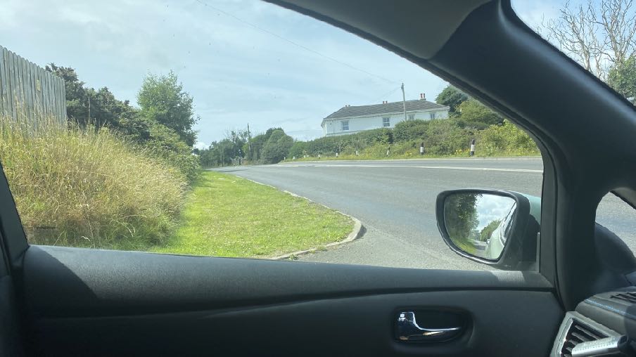
4.4 Such developments need to satisfy the other requirements of the Strategic Plan - notably those which protect the countryside and which ensure that development has an acceptable impact on highway safety. The site is generally well screened from the Douglas direction although from Cooil Road the site is visible. What is proposed does not change the buildings other than introducing cladding which if anything, would reduce its visual impact. We are of the view that there will be no adverse visual impact from the proposal.
View of the site from Cooil Road (A24)
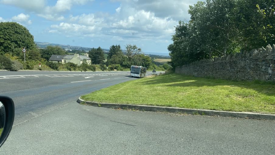
4.8 The proposed development will change the nature of traffic coming to and going from the site. In respect of parking there are significant areas for parking in the yard and hard standing beside the buildings. Whilst 22/01500/B was refused for reasons relating to highway safety, no objection was raised in that application by the Highway Services Division of Department for Infrastructure. Whilst a vehicle waiting to exit the site may have to wait for a break in the traffic, the visibility appears to be good (see photographs below) and indeed approval was recently granted for the use of the site for a festival with camping which generated significantly more traffic of all types using this entrance/exit.
Visibility to the north east
Visibility to the south west
4.9 It is not believed that the proposal will have an adverse impact on highway safety either within or outwith the site and that the proposal should not be refused for these reasons.
4.10 It is fully accepted that the existing buildings are not of architectural or historic interest and as such the proposal cannot be considered to accord with Environment Policy 16 which would usually be the policy which would support the creation of tourist accommodation from the conversion of existing rural buildings. However, we would submit that the Government Strategy on the promotion of tourism is a material consideration and could be taken to override the policies which otherwise presume against development in the countryside. The proposal is not for the erection of new buildings but rather the re-purposing of existing ones which are no longer needed for their originally intended purpose.
4.11 The owners originally had around 15 liveries within the site and in addition were breeding their own Friesian horses. The arena was regularly used and competitions were held indoors and outside. Unfortunately, following the erection of the Energy From Waste Plant those who had their horses on the site were concerned about the contamination of the land and removed their horses elsewhere, despite there being no evidence of contamination of any kind of the site. In addition, there is residential and tourist accommodation in the existing buildings between the existing stables and the arena making it less suitable for the stables to be used for equestrian purposes.
4.12 The arena building continues to be used for purposes associated with the maintenance of the site but in time, if the tourist accommodation proposals develop, it could be that this building could be used for purposes associated with these (recreation, leisure, storage of bicycles etc).
4.13 The photographs show the fence and planting between the house and the stables which will provide enclosure and separation of the two different uses although there will continue to be a sharing of the open garden area to the north of the stables with the house rather than complete exclusion of the stables/tourist accommodation and the other uses in this block of outbuildings.
Conclusion
4.14 We would submit that whilst the Strategic Plan policies do not support the creation of tourist accommodation in areas not designated for such purposes, the Government Strategy on the promotion of tourism clearly demonstrates that there will need to be the
development of tourism related facilities outside of the few areas that are designated for tourism use and indeed the examples given above demonstrate that there have been applications for the creation of tourist accommodation outside of designated areas and settlements which have been considered positively, even in the case of the erection of completely new buildings to accommodate this proposed use.
4.15 The proposal will find a new use for existing buildings which are unlikely to ever be used for the keeping of horses due to their location between existing residential and tourist accommodation and the proposals demonstrate that the building will not be increased in size or height and that its character as stables will be retained and thus the building’s appearance will remain appropriate for its location in the midst of a group of rural outbuildings.
4.16 The amount of traffic coming and going will change, albeit this could be less and with less impact than livery vehicles coming and going if the stables were used for equestrian purposes. The access has been recently approved for use in association with a significant temporary festival and neither that application nor the previous application for an increase in the size of the stables and their conversion to tourist accommodation, were considered negatively by the highway authority.
4.17 The creation of tourist accommodation as proposed would allow visitors to the Island to stay in a beautiful location which is close to a number of public footpaths including that which leads to the old Fair Bridge and onward to the steam railway and station at Port Soderick as well as the glen and beach and coastal footpath network. We believe that the proposal will support the Government’s Tourism and Economic Strategies without any adverse impact on the landscape or environment.
Sarah Corlett 29.08.23
Appendix One
Relevant Strategic Plan policies
Strategic Aim: To plan for the efficient and effective provision of services and infrastructure and to direct and control development and the use of land to meet the community’s needs, having particular regard to the principles of sustainability whilst at the same time preserving, protecting, and improving the quality of the environment, having particular regard to our uniquely Manx natural, wildlife, cultural and built heritage.
Strategic Policy 1: Development should make the best use of resources by: (a) optimising the use of previously developed land, redundant buildings, unused and under-used land and buildings, and reusing scarce indigenous building materials; (b) ensuring efficient use of sites, taking into account the needs for access, landscaping, open space(1) and amenity standards; and (c) being located so as to utilise existing and planned infrastructure, facilities and services.
Strategic Policy 2: New development will be located primarily within our existing towns and villages, or, where appropriate, in sustainable urban extensions(2) of these towns and villages. Development will be permitted in the countryside only in the exceptional circumstances identified in paragraph 6.3.
Strategic Policy 4: Proposals for development must:
(a) Protect or enhance the fabric and setting of Ancient Monuments, Registered Buildings(1), Conservation Areas(2) , buildings and structures within National Heritage Areas and sites of archaeological interest;
(b) protect or enhance the landscape quality and nature conservation value of urban as well as rural areas but especially in respect to development adjacent to Areas of Special Scientific Interest and other designations; and
(c) not cause or lead to unacceptable environmental pollution or disturbance.
Strategic Policy 5: New development, including individual buildings, should be designed so as to make a positive contribution to the environment of the Island. In appropriate cases the Department will require planning applications to be supported by a Design Statement which will be required to take account of the Strategic Aim and Policies.
Strategic Policy 8: Tourist development proposals will generally be permitted where they make use of existing built fabric of interest and quality, where they do not affect adversely environmental, agricultural, or highway interests and where they enable enjoyment of our natural and manmade attractions.
Strategic Policy 10: New development should be located and designed such as to promote a more integrated transport network with the aim to: (a) minimise journeys, especially by private car; (b) make best use of public transport; (c) not adversely affect highway safety for all users, and (d) encourage pedestrian movement.
Spatial Policy 5: New development will be located within the defined settlements. Development will only be permitted in the countryside in accordance with General Policy 3.
General Policy 2: Development which is in accordance with the land-use zoning and proposals in the appropriate Area Plan and with other policies of this Strategic Plan will normally be permitted, provided that the development:
(a) is in accordance with the design brief in the Area Plan where there is such a brief;
(b) respects the site and surroundings in terms of the siting, layout, scale, form, design and landscaping of buildings and the spaces around them;
(c) does not affect adversely the character of the surrounding landscape or townscape;
(d) does not adversely affect the protected wildlife or locally important habitats on the site or adjacent land, including water courses;
(e) does not affect adversely public views of the sea;
(f) incorporates where possible existing topography and landscape features, particularly trees and sod banks;
(g) does not affect adversely the amenity of local residents or the character of the locality;
(h) provides satisfactory amenity standards in itself, including where appropriate safe and convenient access for all highway users, together with adequate parking, servicing and manoeuvring space;
(i) does not have an unacceptable effect on road safety or traffic flows on the local highways;
(j) can be provided with all necessary services;
(k) does not prejudice the use or development of adjoining land in accordance with the appropriate Area Plan;
(l) is not on contaminated land or subject to unreasonable risk of erosion or flooding;
(m) takes account of community and personal safety and security in the design of buildings and the spaces around them; and
(n) is designed having due regard to best practice in reducing energy consumption.
General Policy 3: Development will not be permitted outside of those areas which are zoned for development on the appropriate Area Plan with the exception of….
…(f) building and engineering operations which are essential for the conduct of agriculture or forestry
Environment Policy 1: The countryside and its ecology will be protected for its own sake. For the purposes of this policy, the countryside comprises all land which is outside the settlements defined in Appendix 3 at A.3.6 or which is not designated for future development on an Area Plan. Development which would adversely affect the countryside will not be permitted unless there is an over-riding national need in land use planning terms which outweighs the requirement to protect these areas and for which there is no reasonable and acceptable alternative.
Environment Policy 2: The present system of landscape classification of Areas of High Landscape or Coastal Value and Scenic Significance (AHLV’s) as shown on the 1982 Development Plan and subsequent Local and Area Plans will be used as a basis for development control until such time as it is superseded by a landscape classification which will introduce different categories of landscape and policies and guidance for control therein. Within these areas the protection of the character of the landscape will be the most important consideration unless it can be shown that:
(a) the development would not harm the character and quality of the landscape; or
(b) the location for the development is essential.
Environment Policy 3: Development will not be permitted where it would result in the unacceptable loss of or damage to woodland areas, especially ancient, natural and seminatural woodlands, which have public amenity or conservation value.
Environment Policy 4: Development will not be permitted which would adversely affect:
(a) species and habitats of international importance:
(i) protected species of international importance or their habitats; or
(ii) proposed or designated Ramsar and Emerald Sites or other internationally important sites.
(b) species and habitats of national importance:
(i) protected species of national importance or their habitats; (1) Wildlife Sites are defined in Appendix 1 41
(ii) proposed or designated National Nature Reserves, or Areas of Special Scientific Interest; or
(iii) Marine Nature Reserves; or
(iv) National Trust Land.
(c) species and habitats of local importance such as Wildlife Sites, local nature reserves, priority habitats or species identified in any Manx Biodiversity Action Plan which do not already benefit from statutory protection, Areas of Special Protection and Bird Sanctuaries and landscape features of importance to wild flora and fauna by reason of their continuous nature or function as a corridor between habitats.
Some areas to which this policy applies are identified as Areas of Ecological Importance or Interest on extant Local or Area Plans, but others, whose importance was not evident at the time of the adoption of the relevant Local or Area Plan, are not, particularly where that plan has been in place for many years. In these circumstances, the Department will seek site specific advice from the Department of Agriculture, Fisheries and Forestry if development proposals are brought forward.
Environment Policy 7: Development which would cause demonstrable harm to a watercourse, wetland, pond or dub, and which could not be overcome by mitigation measures will not be permitted. Where development is proposed which would affect a watercourse, planning applications must comply with the following criteria:
(a) all watercourses in the vicinity of the site must be identified on plans accompanying a planning application and include an adequate risk assessment to demonstrate that works will not cause long term deterioration in water quality;
(b) details of pollution and alleviation measures must be submitted;
(c) all engineering works proposed must be phased in an appropriate manner in order to avoid a reduction in water quality in any adjacent watercourse; and
(d) development will not normally be allowed within 8 metres of any watercourse in order to protect the aquatic and bankside habitats and species.
Environment Policy 8: Agricultural buildings will not be permitted on sites where their existence and associated discharges would result in a breach of the “Code of Good Agricultural Practice for the Protection of Water.” (1)
Environment Policy 10: Where development is proposed on any site where in the opinion of the Department of Local Government and the Environment there is a potential risk of flooding, a flood risk assessment and details of proposed mitigation measures must accompany any application for planning permission. The requirements for a flood risk assessment are set out in Appendix 4.
Environment Policy 13: Development which would result in an unacceptable risk from flooding, either on or off-site, will not be permitted.
Environment Policy 14: Development which would result in the permanent loss of important and versatile agricultural land (Classes 1-2) will not be permitted except where there is an overriding need for the development, and land of a lower quality is not available and other policies in this plan are complied with. This policy will be applied to
(a) land annotated as Classes 1/2 on the Agricultural Land Use Capability Map; and
(b) Class 2 soils falling within areas annotated as Class 2/3 and Class 3/2 on the Agricultural Land Use Capability Map.
Environment Policy 15: Where the Department is satisfied that there is agricultural or horticultural need for a new building (including a dwelling), sufficient to outweigh the general policy against development in the countryside, and that the impact of this development including buildings, accesses, servicing etc. is acceptable, such development must be sited as close as is practically possible to existing building groups and be appropriate in terms of scale, materials, colour, siting and form to ensure that all new developments are sympathetic to the landscape and built environment of which they will form a part.
Only in exceptional circumstances will buildings be permitted in exposed or isolated areas or close to public highways and in all such cases will be subject to appropriate landscaping. The nature and materials of construction must also be appropriate to the purposes for which it is intended.
Where new agricultural buildings are proposed next to or close to existing residential properties, care must be taken to ensure that there is no unacceptable adverse impact through any activity, although it must be borne in mind that many farming activities require buildings which are best sited, in landscape terms, close to existing building groups in the rural landscape.
Environment Policy 16: The use of existing rural buildings for new purposes such as tourist, or small-scale industrial/commercial use may be permitted where:
a) it is demonstrated that the building is no longer required for its original purpose and where the building is substantially intact and structurally capable of renovation;
b) the reuse of the building will result in the preservation of fabric which is of historic, architectural, or social interest or is otherwise of visual attraction;
c) it is demonstrated that the building could accommodate the new use without requiring extension or adverse change to appearance or character;
d) there would not be unacceptable implications in terms of traffic generation;
e) conversion does not lead to dispersal of activity on such a scale as to prejudice the vitality and viability of existing town and village services; and
f) the use of existing buildings involves significant levels of redevelopment to accommodate the new use, the benefits secured by the proposal in terms of impact on the environment and the rural economy shall outweigh the continued impact of retaining the existing buildings on site.
Proposals to convert rural buildings to residential accommodation will be considered along with the advice given at Section 8.10 of this document.
Environment Policy 22: Development will not be permitted where it would unacceptably harm the environment and/or the amenity of nearby properties in terms of: i) pollution of sea, surface water or groundwater; ii) emissions of airborne pollutants; and iii) vibration, odour, noise or light pollution.
Housing Policy 4: New housing will be located primarily within our existing towns and villages, or, where appropriate, in sustainable urban extensions(1) of these towns and villages where identified in adopted Area Plans: otherwise new housing will be permitted in the countryside only in the following exceptional circumstances:
(a) essential housing for agricultural workers in accordance with Housing Policies 7, 8, 9 and 10;
(b) conversion of redundant rural buildings in accordance with Housing Policy 11; and
(c) the replacement of existing rural dwellings and abandoned dwellings in accordance with Housing Policies 12, 13 and 14.
Housing Policy 11: Conversion of existing rural buildings into dwellings may be permitted, but only where:
(a) redundancy for the original use can be established;
(b) the building is substantially intact and structurally capable of renovation;
(c) the building is of architectural, historic, or social interest;
(d) the building is large enough to form a satisfactory dwelling, either as it stands or with modest, subordinate extension which does not affect adversely the character or interest of the building;
(e) residential use would not be incompatible with adjoining established uses or, where appropriate, land-use zonings on the area plan; and
(f) the building is or can be provided with satisfactory services without unreasonable public expenditure. Such conversion must:
(a) where practicable and desirable, re-establish the original appearance of the building; and
(b) use the same materials as those in the existing building.
Permission will not be given for the rebuilding of ruins or the erection of replacement buildings of similar, or even identical, form.
Further extension of converted rural buildings will not usually be permitted, since this would lead to loss or reduction of the original interest and character.
Housing Policy 15: The extension or alteration of existing traditionally styled properties in the countryside will normally only be approved where these respect the proportion, form and appearance of the existing property. Only exceptionally will permission be granted for extensions which measure more than 50% of the existing building in terms of floor space (measured externally).
Housing Policy 16: The extension of non-traditional dwellings or those of poor or inappropriate form will not generally be permitted where this would increase the impact of the building as viewed by the public.
9.5.5 In recognition of this the Department proposes that new forms of contemporary tourism development will be welcomed, particularly those that satisfy customer demand for high quality accommodation in rural areas provided that they comply with the policies in the plan. Farmhouse accommodation or quality self catering units in barn conversions and making use of rural activities will be encouraged but must comply with General Policy 3 and Business Policy 9. Other forms of quality accommodation in rural areas will be considered, including the provision of hostels and similar accommodation suitable for walkers but must comply with General Policy 3 and Business Policy 11.
Business Policy 11: Tourism development must be in accordance with the sustainable development objectives of this plan; policies and designations which seek to protect the countryside from development will be applied to tourist development with as much weight as they are to other types of development. Within the rural areas there may be (1) Tourism Strategy 2004 – 2008 Fit for the Future Department of Tourism and Leisure April 2004 87 situations where existing rural buildings could be used for tourist use and Environment Policy 16 sets out the circumstances where this may be permitted.
Business Policy 12: Permission will generally be given for the conversion of redundant buildings in the countryside to tourist use providing that the development complies with the policies set out in paragraph 8.10. – Housing Policy 11.
Appendix Two
Landscape Character Assessment
D10 – BRAAID Key Characteristics
• Gently undulating land sloping down south-eastwards towards the coast with numerous notable rounded hill tops.
• Rough heathland vegetation.
• Coniferous Chibbanagh Plantation on hill tops and higher exposed areas.
• Large open predominantly pastoral fields with low Manx hedges and gorse spreading from hedgerows into more elevated fields in numerous places creating a semi-upland character.
• Sparsely settled area with some scattered farmhouses surrounded by trees in an otherwise open and treeless area.
• Numerous historic settlements and elements such as Long and Round houses at Braaid and remains of Broogh Fort.
• Small gullies containing burns and low vegetation cut across the fields.
• Mount Murray Golf course and associated buildings near the small linear settlement of Newtown, extending along the A5.
• Sunken lanes enclosed by grassed Manx hedges with some gorse and thorn bushes growing on the top enclosing the road corridor.
Overall Character Description Rolling landscape gently slopes south-eastwards towards the coast with notable gently rounded hills covered in a patchwork of large open rectilinear and predominantly pastoral fields bounded by low Manx hedges in a variable state of repair with gorse and other low shrubs growing along field boundaries in places. Patches of gorse spread from the field boundaries into fields of rough grazing on the hill tops around the Chibbanagh coniferous plantation, as well as on the more elevated areas to create a semi-upland feel with heather and patches of bracken beginning to dominate in the abandoned upper fields. Numerous small burns cut across and drain the relatively geometric field pattern with low scrub, waterside vegetation and some small trees growing in the small gullies. The majority of these burns drain into Santon Burn that forms the western boundary, beyond which the character changes to become less open with no rounded hill tops in the Ballamodha and St. Mark’s and Earystane landscape character area. To the north, the land drops down the
Greeba valley side into a more wooded area, while to the east, the character area meets the more wooded area of Santon with its numerous incised river valleys.
The area is sparsely settled with the few scattered farmsteads in the north of the area shielded from winds by shelter belt trees, while the south-east of the area contains the small linear settlement of Newtown, which extends along the A5 as well as the Mount Murray Golf course complex with numerous buildings, roads and screen planting along the site boundary. A network of small sunken lanes and A-roads, enclosed by tall grassed Manx hedges, cuts across the area, with gorse and other shrubs growing on top of the grassed roadside banks that help to merge the roads into the wider landscape. The Round and Long houses at Braaid represent one of the area’s numerous archaeological sites. These, together with the Broogh Fort north-east of Newtown, demonstrate a history of habitation in this elevated area. There is a relatively tranquil and rural feel in the area away from the main roads that lead out of nearby Douglas. The open fields and rounded hills create a simple and unified landscape character.
Key Views
• Extensive uninterrupted panoramic views from higher points over large open fields and Greeba Valley and the northern Uplands and eastwards to the built-up edge of Douglas.
• Some glimpsed views over fields from most sections of roads, which are enclosed by high grassed Manx hedgerows for the most part.
Historic Features
• Disused mine.
• Round and Long houses at Braaid.
• Broogh Fort and Motte.
Ecological Features
• Farmland grassland habitats.
• Marginal periphery moorland habitats at edges of coniferous plantations.
• Mature network of hedgerows containing deciduous trees in field boundaries.
• Small aquatic and riparian waterside habitats in the numerous small drainage ditches.
• Some small clumps of deciduous woodland.
Evaluation of Inherent Landscape Sensitivities
• Sparsely settled character, other than at Newtown.
• Mount Murray Golf course development and linear settlement of Newtown.
• Heath vegetation on upper slopes.
• Large predominantly pastoral fields with Manx hedges and gorse in fields.
• Sunken lanes enclosed by grassed Manx hedges with some gorse and thorn bushes.
• Sites of archaeological importance.
• Moderate sense of tranquillity.
Landscape Strategy The overall strategy should be to conserve and enhance the character, quality and distinctiveness of the area, with its open large pastoral fields, its Manx hedges, its scattered farm houses fringed by trees, its sunken and enclosed rural road network and its numerous archaeological features.
D13 - SANTON
Key Characteristics
• A predominantly rural landscape, dissected by A5 and A25 roads.
• Densely wooded valley bottoms amongst undulating rolling land with large rectilinear arable and pastoral fields on the gently sloping hill sides and rounded tops.
• Steep sided densely wooded Victorian pleasure Glens of Glen Grenaugh and Port Soderick Glen lead down to the coast.
• Victorian electric railway line and stations runs through the area at the bottom of Crogga Glen.
• Fragmented woodland along field boundaries and along tracks that access the scattered farm houses centred around Quine’s Hill (along the A25) and small settlements of Santon and Ballaveare.
• Sea-facing hill slopes with large open fields running along the cliff tops with gorse, heather and bracken along the cliff top periphery.
• Incinerator chimney forms notable landmark in the immediate area.
• Presence of Manx Milestones.
• Abrupt linear southern built edge to Douglas, comprising residential and industrial development with minor localised extension of industrial character into character area south of Cooil Road.
• Pulrose Golf Course on edge of Douglas
Overall Character Description Numerous gentle to steeply sided river valleys cut down into the landform to form an undulating and rolling character with pronounced incised valleys. Glen Grenaugh and Port Soderick Glen are steepsided densely wooded valleys, the latter appropriated during the Victorian period as pleasure Glens with walkways and features such as bandstands and bridges. Linear fragmented woodland runs along the valley bottoms of these National Glens and along Crogga River. Hedgerow trees and woodland blocks surround the numerous farms in the area, which are predominantly located in the north of the area around Quine’s Hill. Medium sized rectilinear arable and pastoral fields delineated predominantly by Manx hedges and some post and wire fences form a strong geometric field pattern on the gently sloping hill sides and rounded tops in the south of the area. Smaller rectilinear fields enclosed by Manx hedgerows, containing large hedgerow trees, cover the more settled north-eastern area where farmsteads such as Hampton Court and Cronkbane are concentrated. This field pattern stops abruptly in the north of the area where it meets the A24 and the linear built-
up edge of Douglas. The far north-eastern part of the area comprises the Pulrose Golf Course, which extends in towards the centre of Douglas. Patches of gorse and heather grow in areas on the more exposed hill tops and along the eastern edges of the fields of the coastal facing slopes, along which the cliff top coastal path runs and forms the area’s seaward boundary.
The busy A25 runs along the lower valley sides with small, often steep and winding tracks branching off perpendicular from the main road to provide farm access, while smaller predominantly straight B roads, enclosed by tall hedgerow vegetation, which follow the grain of the rectilinear field pattern and link the small and wooded settlements within the area such as Santon and Seafield. The Victorian Electric Railway runs through the area along Crogga Glen with stations at Santon and Port Soderick before skirting around the bottom of Douglas Head which forms the north eastern boundary. Moderate sense of tranquillity away from Douglas and the major roads.
• Open and expansive views from the higher areas along the rugged coast in the east and inland towards the upland areas over Braaid.
• Incinerator chimney forms a notable landmark in the immediate area.
• Glimpsed views framed by vegetation in the valley bottoms and along the main roads where they follow the wooded valley bottoms.
• Views in the northern part of the area up to the Transmitting Masts on top of Douglas Head hill top.
• Views from Isle of Man Steam Railway
Historic Features
• Victorian Isle of Man Steam Railway and stations, including Port Soderick (Registered Building) and the Old Toll Booth (Registered Building).
Ecological Features
• Farmland grassland habitats.
• Mature network of hedgerows containing deciduous trees in field boundaries.
• Aquatic and waterside habitats along river courses.
• Dense riparian woodland in Valley bottom with deciduous woodland along valley sides.
• Exposed heathland on steeper sea facing slopes.
Key Issues and landscape sensitivities
• Wooded horizons and skyline seen from valley bottoms.
• Ecological value of the aquatic and waterside habitats.
• Various sized pastoral and arable fields with Manx hedges.
• Wooded valley bottom with fragmented woodland along substantial field boundaries.
• Scattered farmsteads fringed by trees.
• Wooded Victorian Pleasure Glen at Port Soderick.
• Victorian Isle of Man Steam Railway and stations.
• Presence of Manx Milestones.
Landscape Strategy The overall strategy should be to conserve and enhance the character, quality and distinctiveness of the area, with its wooded valley bottoms and wooded horizons, its scattered settlement pattern, its Victorian pleasure glen and the railway.
Copyright in submitted documents remains with their authors. Request removal