Loading document...
March 2004
Isle of Man Government
area and its proximity to the town centre, the Sulby River and the rural land to the west offer an opportunity to create a quality environment for those who live and work in the area. The Development Framework seeks to identify the key elements of the existing landscape. By incorporating them and creating new structural landscape features, including open spaces and woodland planting, the intention is to provide a strong landscape structure in which to site the various elements of the neighbourhood. 3.2 The towns and villages of the Island have developed their own sense of place over many years. It is particularly important in a major development such as West Ramsey to identify those elements that can help create such a sense of place. This Development Framework aims to identify these elements including river corridors, tree belts, areas of salt marsh and notable buildings.
4.1 Whilst the land use zoning with the Development Framework essentially reflects those within the Ramsey Local Plan the very broad nature of the Ramsey Local Plan zoning has been refined in order to accommodate: 4.1.1 Business park uses within the land zoned for light industrial use at Ballachrink. 4.1.2 A neighbourhood centre to service the residential uses adjoining Gardeners Lane. 4.2 It is also appropriate for the Development Framework to provide guidance on the design of residential layouts by prescribing housing densities in response to topography, flood protection and housing need.
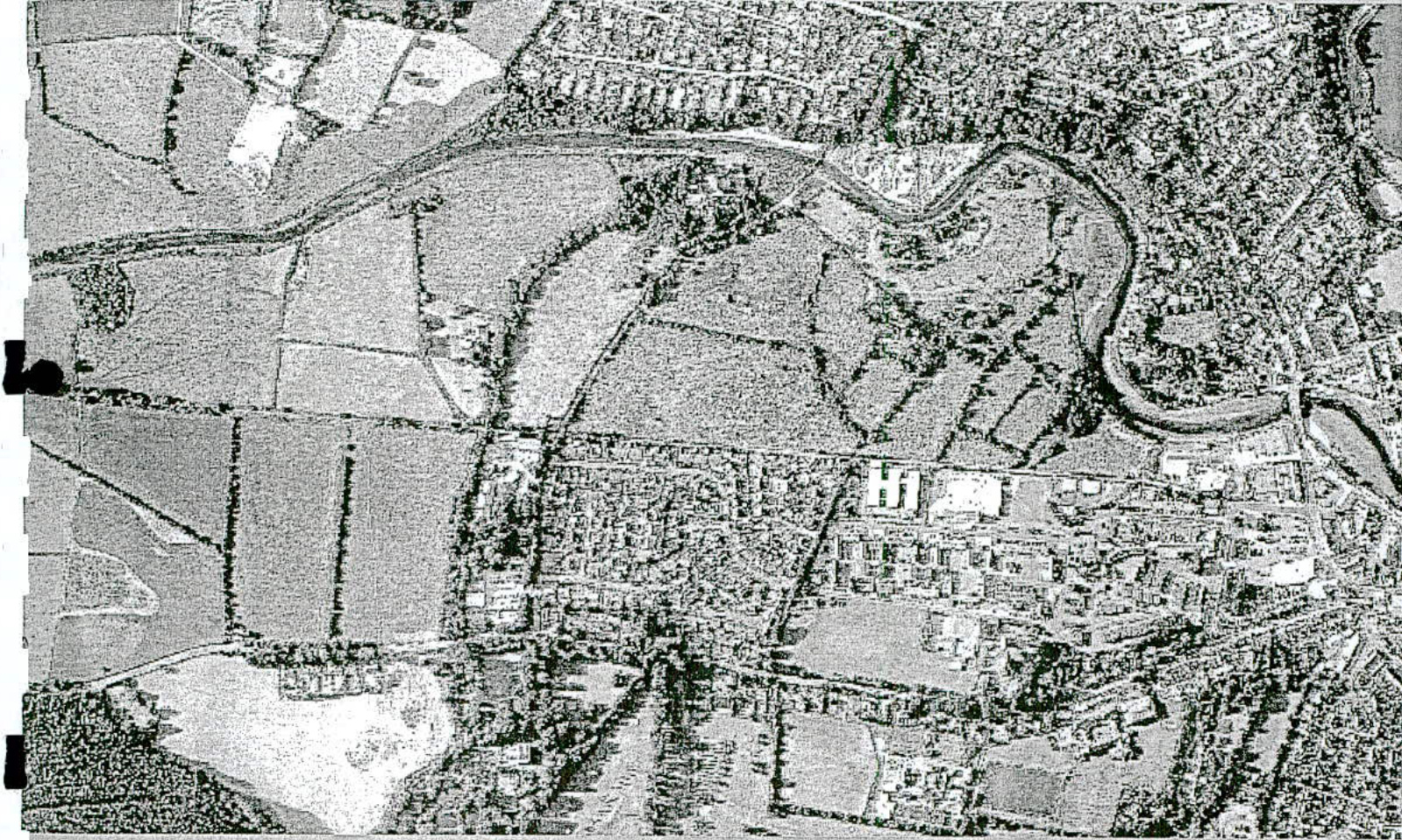
5.1 The Ramsey Local Plan identifies two zones that are suitable for partial or complete residential development: 5.1.1 Poylldooey/Ballachrink (notated "D" in the Ramsey Local Plan and " 2 " \& " 3 " on the key diagram). This area is approximately 11 hectares in size. 5.1.2 Gardeners Lane/Milntown Farm (notated "E" in the Ramsey Local Plan and " 4 ", " 5 " \& " 6 " on the key diagram). This area is approximately 13 hectares in size. In accordance with the Ramsey Local Plan approximately 3 hectares should be used for light industrial purposes. 5.2 Having regard to the nature of the land, housing need, flood risk, the protection of the various interests of the Sulby River and the location of the land relative to other facilities within the Town, it is appropriate to refine the use of these zones as follows: 5.2.1 Within the Poylldooey/Ballachrink area, the land between the new distributor road and the Poylldooey Nature Reserve (as notated " 3 " on the key diagram)
should be developed for low density housing (12-15 dwellings per hectare). This could provide in the order of 60 to 75 homes but is dependant on the requirements of any flood protection and drainage measures (see sections $15 \& 16$ of this document). 5.2.2 Within the Poylldooey/Ballachrink area the land south of the new distributor road (as notated " 2 " on the key diagram) should be developed for medium/high density ( $15-30$ dwellings per hectare). This could provide in the order of 75 to 150 homes. 5.2.3 Between Gardeners Lane and Glen Auldyn River (as notated " 4 " on the key diagram) the land should be developed for a neighbourhood centre to service the needs of the overall development of West Ramsey. The neighbourhood centre could include uses such shops, nursery/crèche facilities, meeting hall, public house. During the consultation process interest in the provision of new community facilities for churches within Ramsey has been highlighted. Land within this area that is not needed for neighbourhood centre uses should be developed for medium/high density housing ( $15-30$ dwellings per hectare). 5.2.4 To the west of the Glen Auldyn River and south of the new distributor road (as notated " 5 " on the key diagram) the land should be developed for medium/high density housing and, if there is sufficient demand, light industrial uses. This could provide in the order of 45 to 90 homes. 5.2.5 To the west of the Glen Auldyn River and north of the new distributor road (as notated " 6 " on the key diagram) the land should be developed for low density housing ( $12-15$ dwellings per hectare). This could provide in the order of 70 to 90 homes. 5.2.6 All development within these areas is dependent on the requirements of any flood protection and drainage measures (see sections $15 \& 16$ of this document). 5.3 Given the wider housing need in Ramsey it is considered that provision should be included within the areas of medium/high density housing for a range of affordable housing in accordance with the housing policies contained in the Draft Strategic Plan published by the Department in July 2001. The exact number, type and location of affordable housing will be the subject of detailed discussion in the context of the planning applications submitted for the various areas. 5.4 The residential layout and design of new houses should create an appropriate sense of place. All planning applications will be required to be accompanied by a Design Statement to demonstrate how the application addresses the key elements of the Development Framework and will assist in a creating a sense of place. The design of new houses should help to establish a specific local character and, where appropriate, take account of the style of the existing buildings within the area. Buildings that could be used for inspiration include Greenlands, Poylldooey House, the Milntown Gatekeeper's Cottage and traditional buildings in Glen Auldyn.
5.5 The layout and design of the residential areas within the West Ramsey area should, where possible, result in energy efficient layout. It is considered that this can potentially be best achieved through the appropriate use of passive solar gain. Applicants and developers are advised to discuss the implications of with the Department as part of any submitted planning applications. 5.6 The land in the Parish of Lezayre beyond the Town boundary (as notated " 7 " on the key diagram) that is zoned on the 1982 Development Plan will, in the long term, form the edge of the Ramsey. The long term development of this area should result in the creation of an attractive landscaped transition between the countryside and the urban area. 5.7 The design of all new housing areas must include adequate open space provision (as indicated in the Ramsey Local Plan and clarified in section 10 of this document) and incorporate features that seek to reduce opportunities for criminal and anti-social behaviour (see appendix 2 of this document).
6.1 The Department and Ramsey Town Commissioners are working on detailed designs for the redevelopment of the Lezayre Road Estate (notated " 8 " on the key diagram), which falls within an area of Predominantly Residential Use under the Ramsey Local Plan. The Development Framework identifies the opportunity to improve access to the area and reduce conflict between vehicles servicing residential and industrial properties in the area by providing a link road from the estate to the new distributor road. This link road is discussed more specifically in section 13 of this document.
7.1 Within the Ramsey Local Plan there are several zones within the West Ramsey area that are identified for industrial use: 7.1.1 Poylldooey/Ballachrink (notated "B" on the Ramsey Local Plan and " 1 " on the key diagram of this document) - Within this area the land south of the new distributor road should be used for light industrial purposes. The land to the north of the new distributor road, if there is sufficient demand, could be used for business park uses. In any case, the siting of new buildings close to the Sulby River and the Poylldooey Nature Trails will demand sensitive design of both the buildings and the spaces around them. 7.1.2 Gardeners Lane/Milntown Farm (notated "C" on the Ramsey Local Plan and " 4 ", " 5 " \& " 6 " on the key diagram of this document) - The Ramsey Local Plan indicates that there should be approximately 3 hectares of land reserved for industrial purposes as part of a scheme for the whole area. This use should only be taken up if there is a need for light industrial development and no development opportunities remain on the Poylldooey/Ballachrink land. If light industrial
Copyright in submitted documents remains with their authors. Request removal
View as Markdown