Planning Statement For The Alteration Of The Existing Multi Purpose Entertainment And Leisure Building, Ballakaighen Farm, Whitebridge Road, Onchan Im4 6Ad
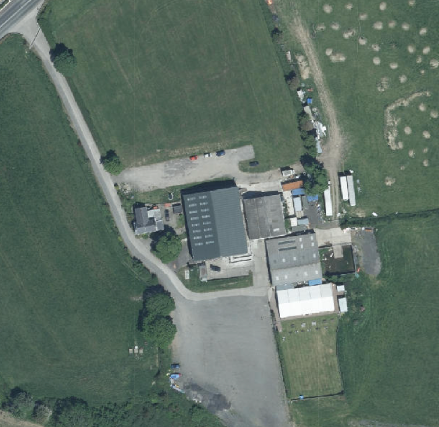
Aerial satellite view of a rural property featuring large industrial or agricultural buildings and gravel parking areas.
1.0 Introduction
1.1 The site is an area within Ballakaighen Farm which sits on the southern side of the A2 as it passes from Onchan to Baldrine. The site lies between the top of Whitebridge Hill and the former Liverpool Arms Public House.
1.2 The farm accommodates a range of buildings and more recently a range of uses, including not only the agricultural use of the majority of the land holding, but also now leisure uses in the form of a temporary marquee used for weddings and other functions, permanent multi purpose leisure and entertainment buildings to the north west of the main building group, the farm house and associated access and car parking areas. The field to the north of the buildings is also used during TT and Manx Grand Prix periods for camping. For the details of all of these uses see Planning History below.
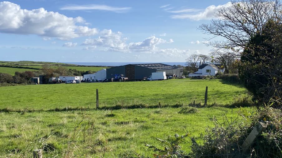
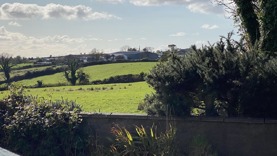
1.3 The site and its buildings are visible variously from both Whitebridge and King Edward Roads.
View from Whitebridge Road close to the entrance to the site
View from opposite the former Liverpool Arms
2.0 Planning policy
2.1 Area Plan for the East
2.1.1 The site lies within an area designated on the Area Plan for the East as not for a particular purpose - effectively countryside as defined in Environment Policy 1 of the Strategic Plan.
2.1.2 On the Area Plan, there is a series of three Constraints Maps which identify a range of potential constraints for development. None of these maps shows any constraints applicable to this site.
2.1.3 The Area Plan adopts the findings of the Landscape Character Assessment which was commissioned by the Department in 2008. The full description of this Character Area is set out at Appendix One but the Area Plan summarises this as follows:
Conrhenny and Groudle (D3) Landscape Strategy Conserve and enhance:
a) the character, quality and distinctiveness of this area of relatively sparse settlement;
b) its valley bottom woodland;
c) its National Glens;
d) the various archaeological features within the area.
Key Views
Dramatic views to an Upland backdrop to the North and West.
Dramatic, panoramic views eastwards across the ever-changing colour and nature of the sea and sky, contribute to strongly recognisable sense of place.
Close and distant views to the northern edge of Onchan/ Douglas settlement, which is visually harsh in places.
Channelled views along the corridor of the Groudle River, which is enclosed in places.
2.1.4 The Area Plan contains a number of references to recreation:
3.6 Desired outcomes…viii. To build upon the excellent opportunities for communities to access good quality open space and space for recreational purposes;…
11.1.1 As part of Government’s Strategic Objectives under ‘An Inclusive and Caring Society’ the general aims are to focus on providing public services that are fit for purpose, modern and in the right place, that improve the quality of life for children and young people and help all to lead longer and healthier lives.
11.2.1 The relevant Policy direction for the Area Plan is set out in the Recreation and Community Policies, particularly Recreation Policies 1 and 5 and Community Policies 1, 5, 6, 8 and 9.
11.4 Area Plan Desired Outcomes…i. Each settlement has sufficient open space and recreation facilities to meet needs over the plan period…
Open Space and Community Recommendation 1 This Plan supports, as highlighted in the Programme for Government, the need for public/private partnerships to provide additional sports, recreation and informal play and amenity space to encourage people to become more active. This should be linked with any Active Travel Plan and any future measures or strategies to better link green infrastructure and open/landscaped spaces in the East to provide a network of accessible and practical ‘greened’ space (see Natural Environment Proposal 1).
2.2 Isle of Man Strategic Plan 2016
2.2.1 This explains that land which is not designated for development should be protected from development which would harm the character and appearance of the countryside Environment Policy 1. There are exceptions listed in General Policy 3 which does not include recreation or leisure facilities.
2.2.2 It is accepted that “The quality of life on the Island and the quality of our environment are improved by attractive open space and by facilities for recreation and other community purposes. This chapter sets out policies which combine to form a land-use planning framework for the provision, protection and enhancement of such space and facilities” (paragraph 10.1.1). It goes on “10.2.1 The Sport and Recreation
Strategy 2002-2012 – “Planning for Sport” sets out a vision for the continued development and growth of sport on the Island and the benefits that this will bring. The Island is fortunate in that over the recent years a network of sporting facilities has been provided across the Island. The Sport and Recreation Strategy envisages improving on these both in terms of sport development and, as appropriate, new facilities.”
2.2.3 “10.2.1 The Sport and Recreation Strategy 2002-2012 – “Planning for Sport” sets out a vision for the continued development and growth of sport on the Island and the benefits that this will bring. The Island is fortunate in that over the recent years a network of sporting facilities has been provided across the Island. The Sport and Recreation Strategy envisages improving on these both in terms of sport development and, as appropriate, new facilities.”
2.2.4 The Strategic Plan encourages the best use of previously developed land, redundant buildings, unused and underused land and buildings (Strategic Policy 1).
2.2.5 Development is expected to provide sufficient car parking, taking into account the standards in Appendix 7 (Transport Policy 7) and that it does not have an adverse impact on highway safety (Transport Policy 4).
2.2.6 Whilst the site is not designated for development, the general standards set out in General Policy 2 are expected to be met regardless of where a development may be proposed.
3.0 Planning history
3.1 The site has been the subject of a number of applications which have established the tourism, leisure and recreation use of this farm.
3.2 The site was first proposed to accommodate leisure facilities in 2003:
• 03/00729/C - change of use of agricultural land and barn for paintball games and indoor laser games. This application was permitted.
• 05/00326/B permitted the conversion of existing barns to an activity centre with parking, drive widening and entrance alterations.
• 06/00866/13 sought planning approval for alterations to existing sludge pit and erection of a building to incorporate leisure facilities at Ballakaighen Farm, Whitebridge Road, Onchan. This application was refused on the 8th February 2007. A subsequent appeal against the refusal was dismissed by the Minister, in accordance with the recommendation of the appointed Planning Inspector, with the appeal refusal decision issued on the 24th July 2007. Minister’s decision: However, he accepts that there is, in the submitted application, insufficient information to enable proper assessment of either the acoustic impact or the highway impact (in terms of both vehicular and pedestrian movements). He therefore accepts the recommendation that the appeal should be dismissed, albeit without prejudice to a further application which includes sufficient detail and technical information in respect of noise and traffic, and, if appropriate, measures to mitigate the impacts thereof.
• 08/00454/B saw approval for an extension of the existing car park.
• 08/00456/D - illuminated signage - refused
• 08/01134/B sought planning approval for the erection of a marquee, toilet blocks and creation of decking at Ballakaighen Farm, Whitebridge Road, Onchan. This application was refused on the 30th September 2008. Reason - the fact it was a new build and not reuse of an existing building in line with policy.
• 08/01403/C sought planning approval for the change of use of two fields from agricultural to recreational and location of a portacabin at Ballakaighen Farm, Whitebridge Road, Onchan. This application was refused on the 30th September 2008.
• 09/01320/R sought planning approval for the creation of a toilet block at Ballakaighen Farm, Whitebridge Road, Onchan. The Planning Committee declined to consider the planning application on the grounds it was substantially the same as one (08/01134/B) refused in the previous five years.
• 10/00838/B saw approval at appeal granted for the seasonal erection of a marquee and portable toilet block to accommodate corporate functions and events between 1 May and 30 September. The application was initially refused under delegated powers and an inspector recommended that the subsequent appeal be dismissed, however the application was approved by the Deputy Minister. He rejected the objection on the basis of appearance saying that it would look like a temporary structure in a compact group of buildings some distance from the roads and the impact on Sunnyside could be addressed by conditions restricting the times of use (Condition 3 sets out, "Events on Sundays to Thursdays shall finish by 22.00. Events on Fridays or Saturdays shall finish by midnight.”). Condition 4 sets out, "Events finishing after 22.00 may occur no more frequently than twice in each calendar month.").
• signage was permitted at the entrance off the A2 under 10/01728/D.
• 11/00459/C saw approval granted for the additional use of agricultural land for recreation activities, further extension of the var park and zorbing tracks.
• 14/00242/C was approved for the erection of a temporary camp site for 50 tents during TT and MGP periods and for a period of 2 years.
• 15/00036/C - Erection of a temporary camping area with associated parking, fencing and welfare facilities to operate during the TT Festival fortnight (May/June 2015 and 2016) and Festival of Motorcycling fortnight (August/September 2015 and 2016) only - permitted subject to the following condition:
2. There shall be a maximum of 110 tents pitched within the site. There shall be no pitching of tents outside the area outlined red on the site plan received on 10th February 2015. Reason: In the interests of public amenity.
• 15/00812/B for, "Demolition of two existing stone barns, erection of a multi-purpose building for entertainment and leisure activates and creation of an overflow car park" this was approved at Planning Committee subject to various conditions relating to bats, hours of use and landscaping, as set out below.
Condition 3 sets out, "Events on Sundays to Thursdays inclusive shall finish by 22:00. Events on Fridays or Saturdays shall finish by midnight. Reason: To provide adequate safeguards for neighbouring residential amenity."
Condition 4 sets out, "Events taking place within the land edged red and blue on Drawing P01 (date-stamped as having been received 20th July 2015), and finishing after 22:00, may occur no more frequently than twice in each calendar month. Reason: To provide adequate safeguards for neighbouring residential amenity."
• 16/01129/C - Creation of a campsite with associated parking, fencing, welfare facilities and signage - permitted
There shall be a maximum of 110 tents pitched within the site. There shall be no pitching of tents outside the area outlined red on the site plan Nr P01 REV C received on 28th September 2016. Reason: In the interests of public amenity.
This permission is for a camping use only and the use shall not be carried out outside the TT and Motorcycle Festival practice and race weeks save for an additional two days for setting up and two days for dismantling the camp site.
• 16/01367/C - change of use of field to campsite - permitted
There shall be a maximum of 50 pitches within the site. There shall be no pitching of tents outside the area outlined in green rectangular hatching on the site plan Nr P01 REV B received on 21st February 2017. No permission is granted for the use/ parking of the site for caravans or motorhomes. Reason: In the interests of public amenity.
• 17/001233/B - demolition of two existing barns and erection of multi purpose building for entertainment and leisure - refused:
1. Due to the material and colour of the proposed building it would be unduly prominent and visually intrusive in the countryside contrary to the provisions of Strategic Policy 2 and Environment Policy 1, which seek to protect the Manx countryside for its own sake.
2. The evolution of the site has resulted in a poor quality environment for the existing leisure and entertainment uses and the proposal would exacerbate this resulting in increased poor public realm, legibility and character throughout the site contrary to the aims of Strategic Policy 5.
3. Insufficient justification has been made to support the increase in scale of the proposal for such a wide range of uses in an area not allocated for development contrary to the provisions of Strategic Policy 2 and General Policy 3.
• 18/00613/B for, Demolition of two existing stone barns and erection of a multi-purpose building for entertainment and leisure activities, including access road, car park and associated landscaping - permitted
Condition 4 set out, "Events on Sundays to Thursdays inclusive shall finish by 22:00. Events on Fridays or Saturdays shall finish by midnight. Reason: To provide adequate safeguards for neighbouring residential amenity."
• 21/00499/B - variation of condition 4 to PA 18/00613/B to extend operating hours to Events on Sundays to Thursdays inclusive shall finish by midnight. Events on Fridays or Saturdays shall finish by 02:00 - permitted
4.0 The proposal
4.1 Proposed are alterations to create new means of escape from a new upper floor within the building. This is to facilitate the creation of an additional floor of accommodation to be used as additional leisure floorspace. There are no conditions within the original approval which would prevent a new floor being installed within the building, under Section 6(3) of the Town and Country Planning Act 1999. However the additional area will necessitate additional means of escape which will affect the outside of the building and as such, planning approval is required for this proposed change. At present, the area is simply a very high ceiling above the skating area below.
4.2 The works will change the exterior of the building in terms of the introduction of two additional external staircases and door openings, one on the western elevation and one on the southern elevation. No other changes are to be made to the outside of the building.
4.3 Internally, an additional area of flooring amounting to 24m by 12.5m (300 sq m).
4.4 This area will be used for additional indoor recreation space, complementary to the facilities available in the rest of the building. This area would be subject to the same conditions of times of operation as the rest of the building, ie, Events on Sundays to Thursdays inclusive shall finish by midnight. Events on Fridays or Saturdays shall finish by 0200hrs.
4.5 The applicant has undertaken new hedge and tree planting alongside this building and proposes to create a more formally arranged parking area, as shown in the proposed site plan.
5.0 Conclusion
5.1 The proposal, like those which preceded it, does not fall within any of the acceptable exceptions to the presumption against development in the countryside. However, what is proposed is within an existing building with permission for recreation use and what is proposed is an internal change which adds a little over an additional 20% of the existing floor area. This in turn is one building within a complex of three buildings plus a seasonal marquee and as such, what is proposed represents a minor addition to the existing lawful operation.
5.2 The issues are therefore considered to be the visual impact of the proposed external staircases and the capability of the existing car parking facilities to accommodate the traffic which would result from the proposed development.
5.3 The site presently accommodates at least 104 parking spaces in the main parking areas and there is a small area to the rear of the grassed area in front of the temporary marquee site which can accommodate a further 25 with a further 20 spaces in front of the application building.
5.4 Laserblast accommodates 25 persons at a time but as most users are children and are brought in groups, the number of vehicles generated by this element is relatively small around 20 vehicles at most per session.
5.5 The fun barn can accommodate a maximum of 60 children so would be likely to generate a maximum of 40 vehicles.
5.6 The bowling accommodates 36 people maximum per hour so would not generate more than 30 vehicles per session.
5.7 The rollerskating facility is used by mostly teenagers and children with around 20 persons skating at any one time so would generate around 10 vehicles per session.
5.8 The marquee is used for special events with a maximum capacity of 200 persons. However, due to it being a licensed premises and accommodating special events which last longer than the leisure sessions, most people either car share, come by taxi or pre-arranged
bus or coach and would be expected to generate a maximum of 50 vehicles on a busy day. Obviously not all these vehicles are coming at the same time and not all the facilities are
operational at the same time although there will be periods of the day when all may be available for use. At present there is no issue with the accommodation of the vehicles which are generated by the existing lawful uses of these buildings.
5.9 The building which is the subject of this application was permitted on the basis that additional parking was provided to the north of the building. This has not been formally provided but is shown in the submitted drawings and will be provided within the next three months complete with the landscaping which is shown in the drawings which has already been undertaken. This will provide a further 20 spaces, with two accessible spaces being provided to the south of the building, which can also serve the other facilities.
5.10 These additional spaces will, we would submit, more than adequately deal with the additional traffic which will be generated by the proposed additional floor area and complies with the Strategic Plan requirement of one space per 15 sq m of space. Whilst these spaces were to be provided as part of the approval for the original building, they are not currently available to the building and yet the existing parking has proved adequate for it together with the other permitted uses on the site overall. We would not object to a condition which requires that these spaces are provided prior to the use of the facilities which are proposed.
5.11 The external changes are largely the introduction of external means of escape and from the public vantage points available, these additional elements are not likely to be discernible and if seen would not be eye catching or have an adverse visual impact. We would submit that the proposal does not conflict with Environment Policy 1 or the Landscape Character Assessment as the site will remain as a group of agricultural buildings in appearance, within an otherwise open and rural landscape.
5.12 The proposed works will make better use of an approved, existing building with little external change to the building and additional landscaping which has been undertaken. The car parking proposed will more than adequately deal with any additional traffic and car parking, noting that the proposed facilities may well be used in conjunction with the existing facilities - ie people may not come solely to use the facilities within the proposed floor area
but will use them as part of a visit to use many of the other facilities available at the site which cater for a range of ages and different leisure activities.
5.13 The proposal will not have any discernible impact on anyone living in the vicinity of the site, the closes residential property being opposite the entrance and some distance from the building.
Sarah Corlett 25.03.25
APPENDIX ONE
Excerpt from the Landscape Character Assessment 2008 D3 CONRHENNY/GROUDLE Key Characteristics
• Gently rolling topography, which is cut by a series of rivers.
• Contain the relatively narrow corridors of the Groudle and Ballacottier Rivers.
• Patchwork of organised pasture and arable fields delineated by a combination of hedgerows, Manx banks and visible drainage ditches.
• Patches of regular coniferous woodland plantations as visible landmarks with the surrounding landscape.
• Distinctive black and white Manx milestones lining the A2 road corridor.
• Series of scattered, isolated farmsteads (several of which have associated modern farm buildings).
• Sense of enclosure provided by Uplands to the north-west.
• Open views to visually harsh red roofs of modern housing developments at the edge of Onchan dominate views southwards.
• Dramatic, panoramic views eastwards across the ever-changing colour and nature of the sea and sky, contribute to strongly recognisable sense of place.
Overall Character Description This character area encompasses gently rolling topography, which is cut by a series of small rivers and streams, including Groudle River and Ballacottier River, which flow north-south across the area. To the north of Onchan, the Groudle River has been dammed to form two triangular reservoirs, Kerrowdhoo and Clypse, which are visible on the horizon on approach to the area. Landscape within the area is covered by a patchwork of organised pasture and arable fields, which are delineated by a combination of hedgerows and Manx banks. Ditches are also characteristically visible at field boundaries in certain locations.
Three regular-shaped coniferous woodland plantations are situated on sloping land to the northeast of Onchan and provide recognisable sense of place. Set against a dramatic upland backdrop, these woodlands create a sense of enclosure surrounding Conrhenny equestrian centre and provide recognisable landscape features within an otherwise predominantly open landscape.
To the south, the area is served by the main A2 road, which runs along the coastline and connects Douglas in the south to Laxey in the north. A series of relatively quiet, rural roads lead northwards from this main road corridor, towards the upland backdrop. Settlement pattern consists of a series of scattered, isolated farmsteads, several of which have visually intrusive modern farm buildings in proximity to the older, traditional farmhouses. A sense of enclosure is provided by Uplands to the northwest.
Overall, there is a relatively strong sense of tranquillity throughout the character area, at distance from major roads corridors and the edges of Onchan. To the north of Onchan, the geometric course of the A18 (TT course), with several viewing platforms and Marshals’ boxes, provides a recognisable transport corridor within the area. The sense of tranquillity is greatly disturbed during TT season.
The meandering path of the Groudle River (which is enclosed and wooded in places) abuts the north-eastern edge of Onchan and flows eastwards to join the sea at Port Groudle. Just to the south of this river corridor, King Edward Bay golf course (situated on a prominent hill, and consisting of several areas of rough grassland and heathland) provides a distinct and recognisable landscape feature. In several places, open views to visually harsh red roofs of modern housing developments at the edge of Onchan dominate views southwards. Dramatic, panoramic views eastwards across the ever-changing colour and nature of the sea and sky, contribute to a strongly recognisable sense of place.
Key Views
• Dramatic views to an Upland backdrop to the north and west.
• Dramatic, panoramic views eastwards across the ever-changing colour and nature of the sea and sky, contribute to strongly recognisable sense of place.
• Close and distant views to the northern edge of Onchan/ Douglas settlement, which is visually harsh in places.
• Channelled views along the corridor of the Groudle River, which is enclosed in places.
Historic Features
• St. Adamnan’s/Lonan Old Church
• Standing stones and tumuli
Ecological Features
• Biodiversity value within regular patches of predominantly coniferous woodland.
• Stream corridors.
• Intact network of mature hedgerows.
Evaluation of Inherent Landscape Sensitivities
• Fragmented woodland in valley bottoms.
• Rivers and reservoirs with riparian habitats.
• Scattered settlement pattern of isolated farms and hamlets.
• Sites of archaeological importance.
• Manx Milestones by roadside.
• Well-vegetated character alongside A-roads.
• Victorian Isle of Man Steam Railway and station.
Landscape Strategy The overall strategy is to conserve and enhance the character, quality and distinctiveness of this area of relatively sparse settlement, its valley bottom woodland, its National Glens and the various archaeological features within the area.
Copyright in submitted documents remains with their authors. Request removal