Planning Statement In Support Of An Application For The Replacement Of The Existing Dwelling, Strathallen, Main Road, Ballabeg, Arbory Im9 4Lj
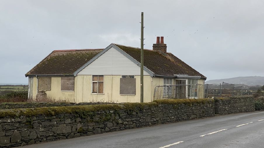
A photograph of a single-story cream bungalow with boarded windows and a conservatory extension, situated behind a stone wall along a rural road.
1.O Introduction
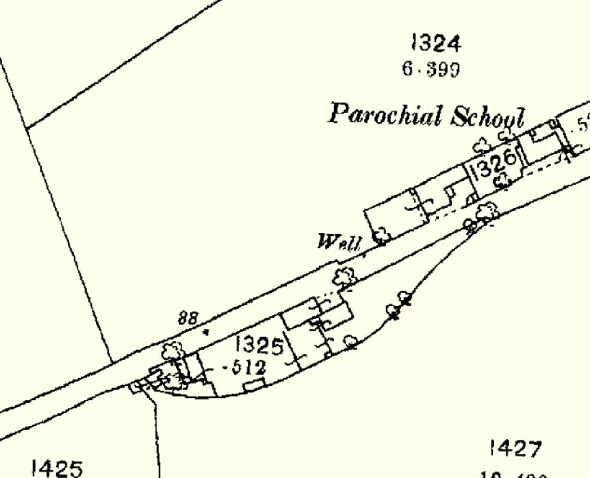
This image displays a historical site plan or map extract showing property boundaries, building footprints, and features like a 'Parochial School' and a 'Well'.
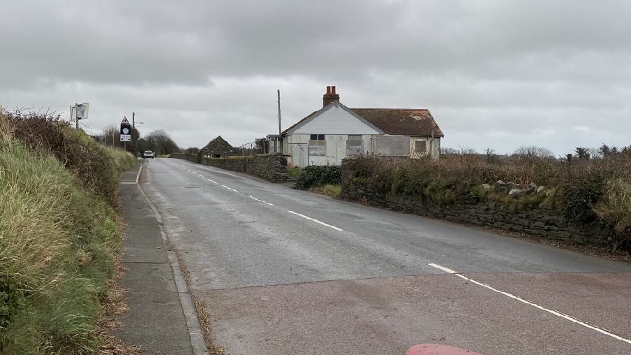
1.1 Strathallen is an existing single storey dwelling situated on the southern side of the A7 which links Ballabeg to Port Erin, running through the settlement of Colby. Strathallen sits on the outskirts of Ballabeg, slightly south west of Arbory Primary School but largely on its own in the landscape other than for a small stone building to the north east.
1.2 The property has a limited sized curtilage although has a vehicular access from the public highway and provision for the parking of a vehicle off the highway.
1.3 The property is clearly visible as one proceeds in both directions along the A7 and is the first property on the south of the road as one enters Ballabeg and the last as one leaves in this part of the hamlet.
1.4 The property is not traditional or historic in any way but is on the site of a building which appears on the 1860s maps.
1.5 The stone barn which currently exists to the east of the site, also appears on the 1860smap but as part of a pair of buildings only one of which is left now. This is not within theownership or control of the applicant.
A street-level photograph showing a white single-story dwelling situated alongside a rural road, flanked by stone walls and vegetation.A street-level photograph showing a rural road with a stone wall, a dilapidated stone outbuilding, and a white bungalow in the background.
1.6 The existing dwelling is a true bungalow and finished in red asbestos diamond laid roof tiles, with a small chimney offset from the western gable. The walls are a combination of white cladding and asbestos cement panelling with a small flat roofed porch on the front in the centres of the elevation which faces the main road. A small pedestrian gate sits directly in front of the porch giving access onto the highway.
1.7 The bungalow has a rear extension and a small glazed annex on the western elevation. Until recently there was also a detached garage within the site which has been demolished to facilitate access to clear and tidy the site and gain better access to the dwelling.
A street-level photograph showing a single-story detached bungalow situated behind a stone wall and wire fence, likely the existing property to be replaced.
1.8 Planning approval was sought for the replacement of the existing dwelling under 23/01120/B, the only application which appears to have been submitted for the property since the 1980s. That application was withdrawn and this current application seeks to address issues which were raised during the consideration of that withdrawn application.
2.0 Planning Policy Context
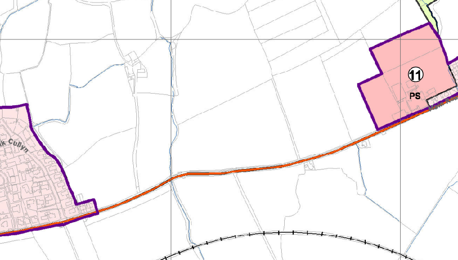
A planning map showing the application site highlighted in pink with a purple boundary, located near a road and a settlement.
2.1 The site lies within an area designated on the Area Plan for the South as not for a particular purpose and outwith the settlement boundaries of both Colby and Ballabeg (the purple lines on the plan below):
2.2 There are no constraints shown on the accompanying map other than the nearby electricity substation.
2.3 There is a presumption against development in such areas as set out in General Policy 3 of the Strategic Plan. However, this includes the replacement of existing rural dwellings (Housing Policies 12 and 14) and the reinstatement of existing former dwellings (Housing Policy 13). Whilst not listed in General Policy 3, there are also policies which allow for the extension of existing rural buildings (Housing Policies 15 and 16).
2.4 There are also policies which require that development has an acceptable impact on highway safety (Transport Policies 4 and 7) and a suite of policies which set out general standards of development although couched in terms of “Development which is in
accordance with the land-use zoning and proposals in the appropriate Area Plan and with other policies of this Strategic Plan” (General Policy 2).
2.5 The site lies within an area shown on the Landscape Character Assessment of 2008 as F8 - Poyllvaaish and Scarlet Undulating Lowland Plain. The boundary of this site is a rather thick line which runs across the site and the A7 but is understood to indicate that this landscape character type covers the land to the south of the A7. The full landscape assessment in the original document is set out at Appendix 2 and the summary included in the Area Plan for the South is set out below:
The overall strategy is to conserve the strong sense of openness throughout the area, with strong field pattern as well as the setting of the numerous archaeological sites and wartime structures within the area.
Key Views Open and panoramic views out to sea, up to the Southern Upland peaks over open fields and towards the built-up areas of Castletown and Ballasalla are obtained from various slightly elevated positions within the area, where the cumulative effects of hedgerow trees does not intervene.
Foreshortened views in some flatter areas where the accumulated effects of hedgerow trees create a wooded horizon.
2.6 There are four Landscape Proposals which accompany this section of the Written Statement but none is directly applicable to this site.
2.7 Environment Policy 1 presumes against development which would adversely affect the countryside.
3.0 The Proposal
3.1 Proposed is the replacement of the existing dwelling with a new dwelling. All of the existing building will be demolished and replaced with a completely new dwelling.
3.2 The existing dwelling has a floor area of 95 sq m over a single floor of accommodation. This does not include the footprint of the detached garage which was recently demolished.
3.3 What is proposed has a footprint of approximately 82 sq m but has two floors of accommodation with a total floor area of 161 sq m and is 3.47m taller.
3.4 The proposed dwelling is a traditional Manx cottage following the principles of the Planning Circular 3/91 for the Design of Residential Development in the Countryside in terms of the length of frontage, pitch and finish of the roof, position and proportion of chimneys, external finish materials of the walls and proportion and arrangement of windows and doors.
3.5 The rear elevation is more modern with larger areas of glazing and solar panels arranged on the roof. This elevation is largely unseen as it faces away from the highway but is nevertheless attractive and interesting and from a distance retains the traditional proportions and profile of a Manx cottage.
3.6 The proposal involves alteration of the means of access into the site. Currently there is a single vehicle width entrance/exit which offers limited width and manoeuvrability (a vehicle would struggle to turn around to enter and leave the site in a forward gear): what is proposed is a new entrance to the east of the frontage which provides a 4m wide entrance and visibility splays of 2.4m by 43m in both directions. The speed of traffic at this point is limited to 30mph.
3.7 The existing vehicular entrance will be blocked off with a new stone wall to match the existing on each side. There us sufficient space within the plot for two vehicles to park side by side and for vehicular manoeuvring to allow them to access and egress the site in a forward gear.
3.8 The property will be connected to the existing combined main sewer as existing.
4.0 Assessment
4.1 The existing building is a dwelling which is considered to be of poor form, both visually and structurally - in terms of the materials of its construction and finish and its thermal and energy efficiency. Housing Policy 12 provides support for the replacement of an existing dwelling where where it has not lost its habitable status by abandonment and where it is not considered to be of historic or architectural interest.
4.2 There are four potential tests for abandonment:
(i) the structural condition of the building;
(ii) the period of non-residential use or non-use in excess of ten years;
(iii) evidence of intervening use; and
(iv) evidence of intention, or otherwise, to abandon.
Structural condition of the building
4.3 Whilst not to modern building standards, the works required to make this property desirable to occupy are largely internal and include relining of the walls, floors and ceilings, re-wiring and re-plumbing, a replacement kitchen and bathroom and the thermal properties of the building need improving - none of which would require planning approval. As such, the building is considered to be structurally sound and capable of use subject to internal works.
4.4 It is understood that the property was last occupied three years ago and rates were paid up and until 2023/24 whereupon the applicant purchased the site. As it was intended to either renovate or replace the property and it would not be occupied until those works were undertaken, the site was zero rated for the duration of whatever works were to be done. Some of the windows were boarded over following some minor vandalism but the windows remain in situ.
4.5 There has been no intervening use of the property or site.
4.6 The evidence of rates being paid and the building being made secure and the site recently cleared of weeds and overgrown vegetation is evidence of an intention to re-occupy the property either by renovation or replacement of the existing dwelling.
4.7 We would submit therefore that the property complies with the requirements of HP12a and is eligible for replacement in this respect.
Architectural or historic interest
4.8 In this case the dwelling is not believed to be the original building on the site and what exists is not considered to have any architectural or historic interest so passes the test of HP12b.
Housing Policy 14
4.9 Having passed the tests of HP12, we believe, it is relevant then to consider the provisions of Housing Policy 14 which goes on to provide advice on replacement dwellings. It requires that:
• it must not be substantially different to the existing in terms of siting and should generally be sited on the “footprint” of the existing
• it must not be substantially different to the existing in terms of size and should have a floor area(1), which is not more than 50% greater than that of the original building (floor areas should be measured externally and should not include attic space or outbuildings).
• in both of the above cases, it must not be substantially different from what exists unless such changes would result in an overall environmental improvement.
• generally, the design of the new building should be in accordance with Policies 2- 7 of the present Planning Circular 3/91, (which will be revised and issued as a Planning Policy Statement).
• exceptionally, permission may be granted for buildings of innovative, modern design where this is of high quality and would not result in adverse visual impact; designs should incorporate the re-use of such stone and slate as are still in place on the site, and in general, new fabric should be finished to match the materials of the original building.
• consideration may be given to proposals which result in a larger dwelling where this involves the replacement of an existing dwelling of poor form with one of more traditional character, or where, by its design or siting, there would be less visual impact.
4.10 The proposed dwelling will be sited on the footprint of the existing with a slight reorientation to provide a south facing rear roof plane to maximise solar gain and to maximise vehicular parking and manoeuvring space with the site.
4.11 The proposed dwelling will be 69% larger than the existing in terms of overall floor area measured externally. Whilst this is larger than the 50% provided for in the first part of the policy, the later part states clearly that Consideration may be given to proposals which result in a larger dwelling where this involves the replacement of an existing dwelling of poor form with one of more traditional character, or where, by its design or siting, there would be less visual impact. It is necessary therefore to either replace the building with one or a more traditional character or result in less visual impact. It does not need to achieve both.
4.12 In this case what is proposed is considered not only to be more traditional than what exists in all senses - proportion, form, materials, style and character - but accords with all of the required criteria in the Planning Circular other than the depth of the house (front to back). The Circular recommends that this measurement is 5.5m whereas what is proposed is 7m. However, with the increase height of modern ceilings, the additional depth of the house reflects well in the overall proportions of the side elevations and height of the property, thus retaining the important profile and proportions of the traditional building form as advocated in the Circular.
4.13 It is our submission that whilst the proposed replacement dwelling is taller than what exists, the relevant policy supports such a replacement where the replacement is of more traditional character. In this case, whilst the adjacent stone barn is not within the same curtilage nor ownership as the house, its proximity provides some context for the replacement dwelling, enabling both buildings to sit more comfortably in the streetscene than what currently exists, and possibly more akin to what existed in the 1860s. What is proposed is also more akin to the existing buildings within the settlement of Ballabeg and thus more sympathetic to its general environment.
4.14 We would draw attention to a recent appeal decision also for a replacement dwelling at Garey House in Lezayre. This property was the subject of 23/01110/B for replacement and also the construction of a stable building. The application was refused under delegated powers for a number of reasons including that the Department considered that the house had lost its habitable status through abandonment (it hadn’t been occupied for 12 years)
and the officer believed that the house was incapable of renovation to habitable standards, despite there being no evidence provided or sought to confirm this. The reasons also included concern about the size of the replacement (63% larger than the existing) and its impact on the landscape which was considered to be significant and adverse.
4.15 The applicant appealed this decision and the application was approved on appeal. The inspector reporting on the application makes a number of observations which we would submit are relevant to the current application:
“64. In this instance, whilst the existing house is in a state of disrepair, it is still clearly recognisable as a dwelling. At the Inquiry, it was a matter of agreement in this regard that it is not structurally unsound. Moreover, the property has only ever been used as a dwelling (there has been non non-residential use of the property, nor any intervening use) although on the evidence of the appellant it was last occupied in around 2007/2208 more than ten years ago.”
4.16 She goes on to report that the applicants had purchased the property with an aim to either renovate or replace the property and marketed it for some time but only recently deciding to replace the property and submit the application therefor. She concludes on hearing this evidence that “Given that background, I am content that there has been no ‘intention’ to abandon residential use of the property. Indeed financially, that wouldn’t make sense”.
4.17 At her paragraph 67 she states, “There is no doubt that work would be required to bring the dwelling up to a condition where it could be lived in comfortably. That said, those works appear, on the basis of the evidence before me to be relatively superficial. Whilst the property is not watertight, it is not structurally unsound and the works that would be required, including things such as roof repairs, general refurbishment and redecorating, garden clearance etc, do not of themselves require planning permission. Indeed, at the Inquiry, the Authority witness confirmed that if the appellant had ‘done up’ the property prior to applying for its demolition and replacement, then its replacement would have been acceptable in principle pursuant to Housing Policy 12. But that makes a nonsense out of the Authority’s position that residential use has been abandoned. Moreover, what would be the point of spending all that money only with a view to then to demolish the building?”
4.18 She goes on to state at her paragraph 68 that “I recognise that the property has not been occupied for more than ten years. However the policy only requires that ‘regard be had’ to a period of non-use for more than ten years. I have had regard to that. However, having read also the Appendix 1 definition and considering Housing Policy 12 in the round, I consider that, on balance, the property has not lost its habitable status/residential use by abandonment. Accordingly I find no conflict with Housing Policy 12 and thus take no issue with the principle of a replacement dwelling here.”
4.19 She goes on to consider the increase in floor area above the existing - 63% noting that “the Policy accepts that changes of siting and size can be appropriate where there would be an overall environmental improvement”. She considers the 63% to be “only marginally over the ‘allowance referred to in the Policy”, noting examples provided of much more significantly larger replacement properties approved in the vicinity, and also notes that the existing house lacks any energy or thermal efficient features whereas the proposed dwelling would be more thermally and energy efficient with solar panels.
4.20 Of course that example is not identical to what is proposed here but the points raised above we consider are important points of principle for the interpretation of policy and regard should be had to them in the consideration of this application. The existing house still appears as a dwelling to all who may see it, most perhaps thinking that it would benefit from some investment either through renovation or replacement with something more appropriate.
4.21 In terms of the impact of its replacement as proposed, to use a phrase coined by another planning inspector - one would not question ‘how the proposed dwelling came to be’, should they encounter it in the street scene.
4.22 The existing building is not structurally unsound and whilst it contains asbestos, there is no requirement for those materials to be removed, only that proper procedures are employed should it be removed and the applicant has already sought specialist advice in this respect.
4.23 We would submit that the proposal will accord with the relevant policies and result in an environmental improvement - visually and energy efficiency wise - as well as benefitting highway safety through the replacement of a difficult and limited access with one that enables more vehicles to be safely parked off the highway and to re-emerge with better and safer visibility for their drivers.
Sarah Corlett 20.12.24
APPENDIX ONE
RELEVANT STRATEGIC PLAN POLICIES
General Policy 2: Development which is in accordance with the land-use zoning and proposals in the appropriate Area Plan and with other policies of this Strategic Plan will normally be permitted, provided that the development:
(a) is in accordance with the design brief in the Area Plan where there is such a brief;
(b) respects the site and surroundings in terms of the siting, layout, scale, form, design and landscaping of buildings and the spaces around them;
(c) does not affect adversely the character of the surrounding landscape or townscape;
(d) does not adversely affect the protected wildlife or locally important habitats on the site or adjacent land, including water courses;
(e) does not affect adversely public views of the sea;
(f) incorporates where possible existing topography and landscape features, particularly trees and sod banks;
(g) does not affect adversely the amenity of local residents or the character of the locality;
(h) provides satisfactory amenity standards in itself, including where appropriate safe and convenient access for all highway users, together with adequate parking, servicing and manoeuvring space;
(i) does not have an unacceptable effect on road safety or traffic flows on the local highways;
(j) can be provided with all necessary services;
(k) does not prejudice the use or development of adjoining land in accordance with the appropriate Area Plan;
(l) is not on contaminated land or subject to unreasonable risk of erosion or flooding;
(m) takes account of community and personal safety and security in the design of buildings and the spaces around them; and
(n) is designed having due regard to best practice in reducing energy consumption.
General Policy 3: Development will not be permitted outside of those areas which are zoned for development on the appropriate Area Plan with the exception of:
(a) essential housing for agricultural workers who have to live close to their place of work; (Housing Policies 7, 8, 9 and 10);
(b) conversion of redundant rural buildings which are of architectural, historic, or social value and interest; (Housing Policy 11);
(c) previously developed land(1) which contains a significant amount of building; where the continued use is redundant; where redevelopment would reduce the impact of the current situation on the landscape or the wider environment; and where the development proposed would result in improvements to the landscape or wider environment;
(d) the replacement of existing rural dwellings; (Housing Policies 12, 13 and 14);
(e) location-dependent development in connection with the working of minerals or the provision of necessary services;
(f) building and engineering operations which are essential for the conduct of agriculture or forestry;
(g) development recognised to be of overriding national need in land use planning terms and for which there is no reasonable and acceptable alternative; and
(h) buildings or works required for interpretation of the countryside, its wildlife or heritage.
Environment Policy 1: The countryside and its ecology will be protected for its own sake. For the purposes of this policy, the countryside comprises all land which is outside the settlements defined in Appendix 3 at A.3.6 or which is not designated for future development on an Area Plan. Development which would adversely affect the countryside will not be permitted unless there is an over-riding national need in land use planning terms which outweighs the requirement to protect these areas and for which there is no reasonable and acceptable alternative.
Housing Policy 12: The replacement of an existing dwelling in the countryside will generally be permitted unless:
(a) the existing building has lost its residential use by abandonment; or
(b) the existing dwelling is of architectural or historic interest and is capable of renovation.
In assessing whether a property has lost its habitable status by abandonment, regard will be had to the following criteria:
(i) the structural condition of the building;
(ii) the period of non-residential use or non-use in excess of ten years;
(iii) evidence of intervening use; and
(iv) evidence of intention, or otherwise, to abandon.
Housing Policy 13: In the case of those rural dwellings which have lost their former residential use by abandonment, consideration will be given in the following circumstances to the formation of a dwelling by use of the remaining fabric and the addition of new fabric to replace that which has been lost. Where: a) the building is substantially intact; this will involve there being at least three of the walls, standing up to eaves level and structurally capable of being retained; and b) there is an existing, usable track from the highway; and where c) a supply of fresh potable water and of electricity can be made available from existing services within the highway.
This policy will not apply in National Heritage Areas (see Environment Policy 6). Permission will not be given for the use of buildings more ruinous than those in (a) above, or for the erection of replacement buildings. Extensions of dwellings formed in accordance with the above may be permitted if the extension is clearly subordinate to the original building (i.e. in terms of floor space(3) measured externally, the extension measures less than 50% of that of the original).
Housing Policy 14: Where a replacement dwelling is permitted, it must not be substantially different to the existing in terms of siting and size, unless changes of siting or size would result in an overall environmental improvement; the new building should therefore generally be sited on the “footprint” of the existing, and should have a floor area(1), which is not more than 50% greater than that of the original building (floor areas should be measured externally and should not include attic space or outbuildings).
Generally, the design of the new building should be in accordance with Policies 2- 7 of the present Planning Circular 3/91, (which will be revised and issued as a Planning Policy Statement).
Exceptionally, permission may be granted for buildings of innovative, modern design where this is of high quality and would not result in adverse visual impact; designs should incorporate the re-use of such stone and slate as are still in place on the site, and in general, new fabric should be finished to match the materials of the original building.
Consideration may be given to proposals which result in a larger dwelling where this involves the replacement of an existing dwelling of poor form with one of more traditional character, or where, by its design or siting, there would be less visual impact.
Housing Policy 15: The extension or alteration of existing traditionally styled properties in the countryside will normally only be approved where these respect the proportion, form and appearance of the existing property. Only exceptionally will permission be granted for extensions which measure more than 50% of the existing building in terms of floor space (measured externally).
Housing Policy 16: The extension of non-traditional dwellings or those of poor or inappropriate form will not generally be permitted where this would increase the impact of the building as viewed by the public.
Transport Policy 4: The new and existing highways which serve any new development must be designed so as to be capable of accommodating the vehicle and pedestrian journeys generated by that development in a safe and appropriate manner, and in accordance with the environmental objectives of this plan.
Transport Policy 7: The Department will require that in all new development, parking provision must be in accordance with the Department’s current standards. Dwellings generally require there to be two parking spaces per unit.
APPENDIX TWO
EXCERPT FROM THE LANDSCAPE CHARACTER ASSESSMENT 2008 F8 – POYLLVAAISH AND SCARLETT PENINSULA Key Characteristics
• Predominantly flat open arable and pastoral land with large rectilinear fields in a rough geometric pattern in close proximity to the coast.
• Little settlement in the area other than a few scattered farms surrounded by small woodland blocks.
• Eastern periphery meets and is influenced by the built up areas of Castletown, Ballasalla and the environs of Ronaldsway Airport.
• Various archaeological sites along the coastal areas including a Viking burial.
• Coastal views over open land with little intervening substantial tree cover.
• Some small rectilinear drainage ditches running along field boundaries.
• Few abandoned limestone quarries now flooded.
• Isle of Man Steam Railway with various stations cuts across the area east-west.
• Relative sense of tranquillity amongst the fields and on the Scarlett Peninsula, but reduced near main roads and Poyll Vaaish quarries.
• Large country estates west of Malew Road
Overall Character Description Predominantly flat open arable and pastoral land with large rectilinear fields in a rough geometric pattern spreads across this area in close proximity to the sea with the Scarlet Peninsula projecting out into Bay-ny-Carrickey. Manx hedges containing gorse, hedgerow shrubs and small windswept trees delineate the large fields that contain grazing stock as well as numerous horses. There is relatively little tree cover in the area with the exception of some fragmented woodland on the slightly higher ground around Balladoole House and along the road that runs to Maddrell’s Bridge.
Other than the Silver Burn, whose lush banks marks the area’s eastern boundary, and the vegetated valley of River Colby in the east of the area, there are few substantially sized water courses in the area. Small drainage ditches run along the sides of some fields with various aquatic species growing in them while numerous flooded limestone quarries in the east of the area represent ecologically valuable freshwater bodies. Field boundaries meet
the coastal strip with irregular edges that abut the low rocky foreshore as the area’s southern boundary follows the coastal path. The area’s northern boundary follows the A7, after which the land starts to gently rise as it leaves this limestone area with numerous nucleated settlements such as Colby and Ballabeg located on the northern edge of the road. The eastern periphery of the area has a few scattered farmsteads with associated outhouses nestled amongst the fields.
The eastern area is also influenced by the built up area of Castletown and Ballasalla, whose grey pebble dashed housing estates form part of the southern boundary around Castle Rushen High School and Maddrell’s Bridge. The numerous straight roads in the area follow the geometric field pattern and are enclosed by Manx hedges and have distinct road markings where they form the route of the Southern 100 Course with numerous viewing platforms and race marshals’ boxes. The Viking burial north of Pooilvaaish is one of the many archaeological sites in the area that include burial mounds and numerous earthworks usually located in prominent positions with sea views. The area has a rural and coastal character with its remoteness impaired slightly by the built-up character of the surrounding areas but with some tranquillity on the Scarlett Peninsula and along the coast.
Key Views
• Open and panoramic views out to sea, up to the Southern Upland peaks over open fields and towards the built-up areas of Castletown and Ballasalla are obtained from various slightly elevated positions within the area, where the cumulative effects of hedgerow trees does not intervene.
• Foreshortened views in some flatter areas where the accumulated effects of hedgerow trees creates a wooded horizon.
Historic Features
• Keeill Vael
• Various Burial Grounds and earth works, most notable being Balladoole Viking Ship Burial.
• St. Lupus’ Church.
• Round house.
Ecological Features
• Flooded limestone quarries with aquatic and marginal habitats.
• Aquatic and riparian waterside habitats in the numerous small drainage ditches, standing bodies of water as well as along Silver Burn and The Colby River.
• Riverside deciduous woodland.
• Farmland and grassland habitats.
• Hedgerow matrix containing high biodiversity and habitats.
• Open coastal views over agricultural land with little substantial woodland.
• Large rectilinear field pattern close to the coast.
• Low Manx hedges containing wind swept gorse and sparsely scattered deciduous trees
Landscape Strategy The overall strategy should be to conserve the strong sense of openness throughout the area, with strong field pattern as well as the setting of the numerous archaeological sites within the area.
Copyright in submitted documents remains with their authors. Request removal