Planning Statement For Additional Use Of Orrisdale Cottages As Residential As Well As Tourist Accommodation, Orrisdale Cottages, Orrisdale, Michael Im6 2Hp
1.0 Introduction
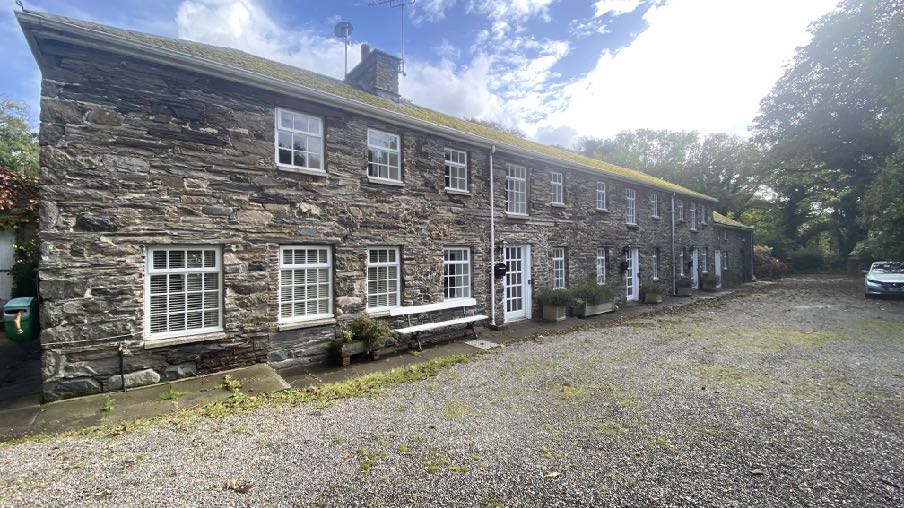
1.1 Orrisdale Cottages are located on the northern side of the Orrisdale Road (C19) which loops to the west of the TT Course and just to the north of Kirk Michael village. The former barn is internally subdivided into three units - Bwaane Jiass, Bwaane Meanagh and Bwaane Twoaie (Manx Gaelic for south cottage, middle cottage and north cottage respectively).
1.2 Bwaane Jiass is a single bedroomed unit, Bwaane Meanagh and Bwaane Twoaie have two bedrooms. All units are two storey and there is a two storey unit with a slightly lower ridge and eaves level, attached to Bwaane Jiass and is internally two rooms one of which is the kitchen of Bwaane Jiass and the other space within this annex is used for storage: this section is not internally accessible from Bwaane Jiass.
1.3 There is a further, detached building to the north east of Bwaane Twoaie which is partly two storey, internally subdivided into two rooms, and used for storage. This is known as Thie Tashtee (treasure house).
1.4 The site has its own access which meets the Orrisdale Road (Rheynn Sloo) alongside the separate access to Orrisdale House which abuts the site to the west.
1.5 The cottages and the house were originally in one ownership. However, in 1999 the sites were separated after the passing of the owner. Both sites are now being offered separately for sale with Cowley Groves, local estate agents: the house has been marketed for approximately three years and the cottages for around a year and a half but remain unsold.
1.6 The cottages have separate access from Orrisdale House and two cottages are served by one septic tank and the third has its own septic tank. Each cottage has its own water, electricity, gas and heating supplies and each is rated separately.
1.7 The cottages are currently managed by Island Escapes and are available for occupation as tourist accommodation (see Planning History).
2.0 Planning Policy Context
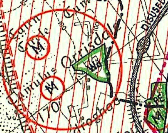
A close-up extract from a topographical map showing grid lines, place names like 'Cairn' and 'Orrisdal', and a red circular boundary line.
Isle of Man Planning Scheme (Development Plan) Order 1982
2.1 The site lies within an area designated on the Isle of Man Planning Scheme(Development Plan) Order 1982 as not for a particular purpose and also within an area ofHigh Landscape or Coastal Value and Scenic Significance (the red diagonal stripes on themap below). The site is also identified as Woodland (the green lines) which confersRegistered status on the trees within the designated area. There is also a wide area ofarchaeological interest (the red circle) which covers a significant area including this site. Theblack dot and dash line below denotes the boundary between Michael and Ballaughparishes.
Draft Area Plan for the North and West
2.2 Cabinet Office is in the process of replacing not only the Isle of Man Planning Scheme (Development Plan) Order 1982 but also all those adopted plans which cover the north and the west of the Island. The draft Area Plan for the North and West was the subject of a public inquiry in July 2024 and although has very limited weight due to the changes which have been implemented up to and including at the public inquiry and also those which may occur following the response by Cabinet Office to the inspector’s report, it is still relevant to consider the provisions of that plan, particularly the detailed background evidence which supports the plan and its recommendations.
2.3 The draft Area Plan designates the site and the surrounding area as not for a particular purpose. The Environmental Constraints Plan identifies the site as within an area of Woodland (the green hatched lines) with the surrounding area being of ecological interest (orange diagonal lines).
2.4 The site is not identified as being at any risk of flooding on the draft Area Plan map although the national flood risk maps show areas of surface water flooding along the access drive and to the rear of the buildings.
2.5 The trees within the site are Registered (RA1317) reflecting the designation as Woodland on the 1982 Plan. The site is not within a Conservation Area and whilst the cottages and outbuildings are not Registered, the adjacent Orrisdale House is included on the Protected Buildings Register (RB 249).
2.6 The draft Plan adopts the findings of the Landscape Character Assessment commissioned by Department of Environment, Food and Agriculture in 2008. The full report as it applies to this site is set out at Appendix One: it is summarised in the draft Area Plan as follows:
Orrisdale and Ballaugh (D4) – Incised slopes Landscape Strategy To conserve and enhance: a) the character, quality and distinctiveness of the area with its patchwork of relatively regular, medium-scale fields, its mature network of low hedges, its tranquil and remote character and its traditional hamlets and scattered farm buildings.
Key views
• Dramatic views to muted upland backdrop to the east.
• Glimpsed views across ever-changing seascape to the west.
• Sweeping views southwards along the course Glen Dhoo to the south.
• Widespread views of Ballaugh Church steeple.
Isle of Man Strategic Plan 2016
2.7 As the site is not designated for development, there is a presumption against development. Exceptions to this general position are set out in General Policy 3. These exceptions include:
(b) conversion of redundant rural buildings which are of architectural, historic, or social value and interest; (Housing Policy 11).
2.8 Further guidance on such conversions are provided and include not only Housing Policy 11 but also Environment Policy 16. HP11 concerns the conversion of redundant rural buildings to a dwelling whereas EP16 relates to conversion to other uses. Both policies require the building to be substantially intact, redundant and of historic or architectural interest amongst other requirements:
Housing Policy 11: Conversion of existing rural buildings into dwellings may be permitted, but only where:
(a) redundancy for the original use can be established;
(b) the building is substantially intact and structurally capable of renovation;
(c) the building is of architectural, historic, or social interest;
(d) the building is large enough to form a satisfactory dwelling, either as it stands or with modest, subordinate extension which does not affect adversely the character or interest of the building;
(e) residential use would not be incompatible with adjoining established uses or, where appropriate, land-use zonings on the area plan; and
(f) the building is or can be provided with satisfactory services without unreasonable public expenditure.
Such conversion must:
(a) where practicable and desirable, re-establish the original appearance of the building; and
(b) use the same materials as those in the existing building. Permission will not be given for the rebuilding of ruins or the erection of replacement buildings of similar, or even identical, form.
Further extension of converted rural buildings will not usually be permitted, since this would lead to loss or reduction of the original interest and character.
Environment Policy 16: The use of existing rural buildings for new purposes such as tourist, or small-scale industrial/commercial use may be permitted where:
a) it is demonstrated that the building is no longer required for its original purpose and where the building is substantially intact and structurally capable of renovation;
b) the reuse of the building will result in the preservation of fabric which is of historic, architectural, or social interest or is otherwise of visual attraction;
c) it is demonstrated that the building could accommodate the new use without requiring extension or adverse change to appearance or character;
d) there would not be unacceptable implications in terms of traffic generation;
e) conversion does not lead to dispersal of activity on such a scale as to prejudice the vitality and viability of existing town and village services; and
f) the use of existing buildings involves significant levels of redevelopment to accommodate the new use, the benefits secured by the proposal in terms of impact on the environment and the rural economy shall outweigh the continued impact of retaining the existing buildings on site.
Proposals to convert rural buildings to residential accommodation will be considered along with the advice given at Section 8.10 of this document.
2.9 These policies are an evolution of the former Planning Circular 3/89 which contained similar advice and restrictions and which was applicable to such developments between 1989 and 2007 when the first Strategic Plan was adopted.
2.10 Development which would be at unacceptable risk of flooding is presumed against (Environment Policies 10 and 13).
2.11 Development is expected to provide sufficient car parking: standards set out in Appendix Seven require two spaces per residential unit (one space for a one bedroomed apartment).
2.12 General Policy 2 sets out a series of standards which development is expected to achieve: General Policy 2: Development which is in accordance with the land-use zoning and proposals in the appropriate Area Plan and with other policies of this Strategic Plan will normally be permitted, provided that the development:
(a) is in accordance with the design brief in the Area Plan where there is such a brief;
(b) respects the site and surroundings in terms of the siting, layout, scale, form, design and landscaping of buildings and the spaces around them;
(c) does not affect adversely the character of the surrounding landscape or townscape;
(d) does not adversely affect the protected wildlife or locally important habitats on the site or adjacent land, including water courses;
(e) does not affect adversely public views of the sea;
(f) incorporates where possible existing topography and landscape features, particularly trees and sod banks;
(g) does not affect adversely the amenity of local residents or the character of the locality;
(h) provides satisfactory amenity standards in itself, including where appropriate safe and convenient access for all highway users, together with adequate parking, servicing and manoeuvring space;
(i) does not have an unacceptable effect on road safety or traffic flows on the local highways;
(j) can be provided with all necessary services;
(k) does not prejudice the use or development of adjoining land in accordance with the appropriate Area Plan;
(l) is not on contaminated land or subject to unreasonable risk of erosion or flooding;
(m) takes account of community and personal safety and security in the design of buildings and the spaces around them; and
(n) is designed having due regard to best practice in reducing energy consumption.
2.13 Where a rural dwelling has fallen into disrepair and has perhaps lost its habitable status, Housing Policy 13 allows for the bringing back of such dwellings to residential properties subject to certain tests:
Housing Policy 13: In the case of those rural dwellings which have lost their former residential use by abandonment, consideration will be given in the following circumstances to the formation of a dwelling by use of the remaining fabric and the addition of new fabric to replace that which has been lost. Where:
a) the building is substantially intact; this will involve there being at least three of the walls, standing up to eaves level and structurally capable of being retained; and
b) there is an existing, usable track from the highway; and where
c) a supply of fresh potable water and of electricity can be made available from existing services within the highway.
2.14 The fabric and setting of Registered Buildings is protected in Strategic Policy 4. The countryside generally is protected from harmful development (Environment Policy 1) particularly areas of High Landscape or Coastal Value and Scenic Significance (Environment Policy 2)
3.0 Planning history
3.1 The site has been subject of only two applications: 83/01124/A and 84/00257/B which both proposed the alterations, conversion and modernisation of three disused cottages to form three holiday cottages. This was permitted subject to, inter alia, a condition which required the cottages be retained in association with Orrisdale House and not to be sold or let separately. Orrisdale House was in the same ownership at the time. A further condition required that the units be let to bona fide tourists with no individual stay exceeding four consecutive weeks.
3.2 The Planning Officer reporting on the approval in principle noted: “The building lends itself to the proposed conversion and there is ample room for car parking and the provision of private gardens for the tourists. Rather attractive stone built outbuilding which is no longer suitable for modern agricultural methods. Walls and roof are fairly sound but all floors, windows and staircases would have to be renewed...the building is next to Orrisdale House which is a very fine looking building and its renovation and conversion would greatly improve the overall appearance of the complex.”
3.3 The stone barn was the subject of application to convert it to a utility, store and gallery (86/01259/B) and a shed was approved for re-roofing (94/01493/B).
4.0 The proposal
4.1 Proposed is the additional use of the three cottages as self contained units for occupancy by residents or tourists (Class 3.3 and 3.6). No changes are proposed to the buildings internally or externally.
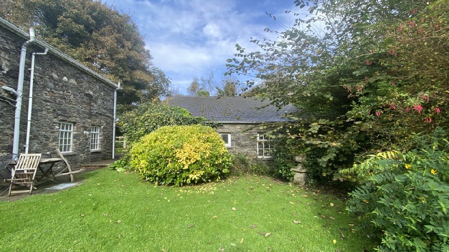
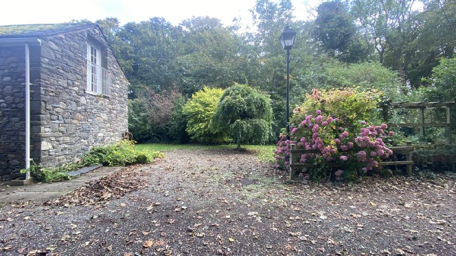
4.2 The plans submitted show how each of the units would be defined although there is no intention in this application to erect fencing or physical features to separate each unit as the retention of a generally open area will better reflect the character of the building and retain its original appearance. Each unit has a pleasant rear garden space with Bwaane Jiass having a larger garden area and parking to the south.
Rear of Bwaane Twoaie
Rear of Bwaane Jiass and Bwaane Meanagh
Side of Bwaane Jiass
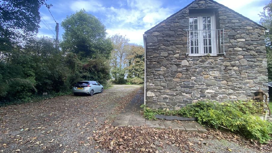
View of the existing parking spaces in front of the building
4.3 The cottages have their own access, separate from that of Orrisdale House. There is good visibility to the west of around 80m. Visibility to the east is impaired by existing vegetation which could be removed should the application be permitted. Traffic levels on the Orrisdale Road is limited to mostly local residents only, the road looping from and back to the A3 and whilst this northern section provides access to the footpath following the route of the former railway line, this is to the east of the site and vehicles parking or accessing this would not generally continue to the application site. Access to the Bollyn Road, an alternative route to Ballaugh Cronk is also to the east of the site and traffic using that will not proceed as far as the application site.
4.4 One of the units has its own septic tank with the other two sharing a second tank within the curtilage of the overall site.
4.5 The plan also shows how the vehicular parking is accommodated (no change to the existing situation).
4.6 No changes are proposed to the two storage buildings which could either remainavailable for all three units or used in connection with one or two.
5.0 Conclusion
5.1 It is relevant that when the conversion was permitted in 1983 the original use of the cottages was residential accommodation in the form of three cottages. At the time, the estate included Orrisdale House and it was considered by the then owner that the residential accommodation in the cottages, which were not being used as dwellings and which had fallen into disrepair, was no longer required but it was felt that the renovation of the disused cottages to another use would retain buildings which were acknowledged by the planning officer at the time to “improve the appearance of the whole complex”.
5.2 There are two ways in which this proposal may be considered in terms of policy: would the use of the cottages as residential have been considered acceptable if it had been applied for originally and also, perhaps more relevant, does the proposal comply with current policy.
5.3 At the time of the original application, Environment Policy 16 and Planning Circular 3/89 were not in place but if they had been the application for conversion to tourist use would undoubtedly have passed the tests in those policies. The building was structurally capable of renovation, was of historic and architectural interest, noting that Orrisdale House went on to be Registered and that the renovation of the cottages was noted by the Planning Officer as improving the appearance of the whole complex. There was a separate access and parking and garden space for the cottages and suitable separation between the main house and the cottages. The cottages could be adequately serviced.
5.4 Similarly, Housing Policy 13 - which guides applications for reinstatement of residential usage - was not in existence in 1983 but had the original application been for renovation and use of the disused cottages as residential accommodation, or indeed had the cottages simply continued to be used for their original purpose, this too is likely to have been considered acceptable or might even not have required planning approval. If the habitable status had been considered to have been lost, the tests in HP13 would have been met existing track to the highway, capable of being provided with water and electricity and the building was completely intact.
5.5 Notwithstanding the above, the current policies which guide such development now allow for buildings of historic or architectural interest and which are redundant for their original purpose to be converted to other uses although in this case of course, the proposal is to allow the buildings to return to their original use as well as being available for tourist accommodation.
5.6 The buildings are not currently used for their original purpose which was residential. As such, it could be said that they were accepted as being redundant for their original purpose when the use was changed to tourist accommodation in 1983/4. However, the proposal intends to return the buildings to their original use so the matter of redundancy is perhaps not as critical as it often might be in such applications. We would submit that the test of whether the cottages are redundant for their current use (tourism) is not relevant as the policy clearly refers to redundancy in terms of the “original” use which in this case is the same as the purpose to which the application proposes the building should be put.
5.7 The additional use as residential would, we would submit, comply with Housing Policy 11: the building is of historic interest and is part of a complex which includes a Registered Building; it is completely intact and in use, no changes are being proposed nor any increase in area and are of a sufficient size to accommodate residential use; the building has all necessary services provided to them without any public expenditure and the residential use would not adversely affect the surrounding area in terms of land use or designation.
5.8 The adjacent property is a residential property subdivided into three units, with other residential dwellings in the vicinity. Permanent occupation of the properties would ensure their continued maintenance and upkeep and occupation compared with tourist accommodation which can be less consistent throughout the year.
5.9 The plans demonstrate that there is sufficient space for two vehicles to be parked in association with each unit and whilst it would be possible to erect fencing to demarcate each residential curtilage, it is not proposed in this application to do this in order to retain the open character of the properties and their curtilages. We would submit that the additional use for residential would allow the use of the three properties as separate units but owned as a single unit, or for them to be occupied and owned separately without any adverse impact on the character of the site itself or the surrounding area.
5.10 At the time of the original application in 1983 the cottages were in the same ownership as and part of the estate of Orrisdale Farm including the main house. The applicant was bequeathed the cottages and the barn to the rear, in 1999, with the house left to another, effectively separating the cottages from the house. It is not considered good planning practice to impose conditions which require that land or buildings are retained in the same ownership as others, mainly because land ownership can and does change without any control by the owners, occupants or even the planning authority. In this case, whilst the
applicant was permitted to occupy Orrisdale House for her lifetime, she was not left the right of ownership of it and was simply given the cottages.
5.11 The cottages have been operated as tourist units since the approval in 1984 but the owner now wishes to sell them. Despite the cottages being available for purchase for over a year, they remain unsold, perhaps demonstrating that they are undesirable as purely tourist accommodation, and the applicant seeks permission for an alternative use for permanent residential accommodation as well as the approved tourist use and removing the requirement for the cottages to be owned in association with Orrisdale House as they currently are not and have not been since 1999.
5.12 Such flexibility in use would allow a range of uses and be more likely to result in the buildings being occupied and maintained which would be in the interests of the character and appearance of the area and the setting and context of the Registered Building, thus complying with Environment Policies 1 and 2, Strategic Policy 4.
5.13 The properties can be provided with adequate parking (General Policy 2 and Transport Policy 7) and the use of the buildings as residential is likely to result in users of the site becoming more familiar with the access and as there is to be no increase in the area of each cottage, and space standards are more restrictive for permanent occupation than tourist apartments, the development will decrease, not increase the amount of traffic coming and going from the site and therefore, no adverse impact on the highway network is likely to arise from the development.
5.14 The development will not have any adverse impact on the adjacent Orrisdale House, each property having its own private garden space, access, services and parking, thus the development complies with those parts of General Policy 2.
5.15 There is no adverse impact from the additional use on ecology, flooding or any of the other elements listed in General Policy 2.
5.16 The proposal we would submit will result in an increased likelihood of use of and investment in the properties which are of historic interest due to their age and unaltered character and their proximity to a Registered Building and would enhance the character and appearance of this part of the Island in full compliance with all of the relevant planning policies. Each unit has adequate access to the relevant services and has a pleasant private
amenity space leading to the site potentially affording a highly attractive place to live as well as to visit as a holiday maker.
Sarah Corlett 19.11.24
APPENDIX ONE
LANDSCAPE CHARACTER APPRAISAL D4 ORRISDALE AND BALLAUGH Key Characteristics
• Gently rolling topography in the north and west, steeper lower slopes of the Northern Uplands to the east.
• Landscape is cut by incised course of Glen Dhoo (opening up to the south of Ballaugh).
• Patchwork of relatively regular, medium-scale fields, delineated by a mature network of low hedges cover the area.
• On the lower slopes of the Northern Uplands, fields are predominantly pasture.
• Settlement pattern is dominated by a series of hamlets (including Orrisdale and Bishopscourt) and isolated farmsteads, which are scattered throughout the area, alongside nucleated village settlement of Ballaugh, containing several white-washed buildings.
• Old Kirk Ballaugh Church (a distinctive, small brick/stone building) provides a recognisable historic feature.
• Glimpsed views westwards across the ever-changing seascape.
• Views to dramatic upland backdrop to the south and east.
• Distinctive black and white kerbs lining the A3 (TT course) which runs through the area along the base of the Uplands to the south.
Overall Character Description Orrisdale and Ballaugh Incised Inland Slopes are situated at the western edge of the Island and encompass farmland, which surrounds the small-nucleated settlement of Ballaugh. In the north and west, topography is gently rolling, facilitating glimpsed distant views across the sea to the west. Further to the east, topography slopes more steeply upwards, forming the lower slopes of Northern Uplands. The relatively steeply incised course of Glen Dhoo cuts northwards through the area, becoming more open to the south of Ballaugh. A patchwork of relatively regular, medium-scale fields, delineated by a mature network of low hedges cover the area. To the east of A3, on the lower slopes fields are predominantly pasture, grazed in several places by sheep. The A3 road corridor (with associated noise and visual intrusion, especially during TT season) cuts across the area and connects a series of minor roads, leading north-west and south-east, towards the coast and the uplands respectively. Settlement pattern is dominated by a series of hamlets (including Orrisdale and
Bishopscourt) and traditional stone isolated farmsteads, which are scattered throughout the area. The nucleated, and relatively modern settlement of Ballaugh (with the church, a landmark within views from the surrounding area) lies at the foot of Glen Dhoo and at the junction between A3 and A10. Settlement character is dominated by a series of white washed houses and shops. The settlement is entered to the west (via A3), over a traditional stone hump-backed bridge, from which, sweeping views southwards along the course of Glen Dhoo can be gained. The old Kirk Ballaugh Church (a distinctive, small brick/ stone building) provides a recognisable historic feature, set against the dramatic upland backdrop to the south. There is a generally strong sense of tranquillity throughout the character area. Sense of remoteness is also relatively strong at distance from small settlements and main road corridors.
Key Views
• Dramatic views to muted upland backdrop to the east.
• Glimpsed views across ever-changing seascape to the west.
• Sweeping views southwards along the course Glen Dhoo to the south.
• Widespread views of Ballaugh Church steeple.
Historic Features
• Old Kirk Ballaugh Church.
• Several Cairns scattered throughout the area.
Ecological Features
• Mature network of low hedgerows at field boundaries.
• Rivers associated with Glen Dhoo and Bishopscourt Glen.
Evaluation of Inherent Landscape Sensitivities
• Mature network of low hedges.
• Ecological value of the aquatic ecosystems and riparian habitats.
• Scattered settlement pattern of traditional farms and hamlets.
• Sites of archaeological importance.
• Sense of tranquillity and remoteness.
Landscape Strategy The overall strategy for the area should be to conserve and enhance the character, quality and distinctiveness of the area with its patchwork of relatively regular, medium-scale fields,
its mature network of low hedges, its tranquil and remote character and its traditional hamlets and scattered farm buildings.
Copyright in submitted documents remains with their authors. Request removal