Planning Statement For The Installation Of Two Containers With Linked Roof, For Agricultural Storage, Land At Renscault Brooghs, West Baldwin, Braddan
1.0 Introduction
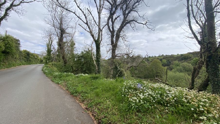
1.1 The site extends to 25 acres situated on the eastern side of the West Baldwin Road (B22). This land spans both sides of the River Glass and abuts the main road from the vehicular entrance opposite an existing residential dwelling, Tillyloss and to the north; agricultural land to the east and the Ballachrink Bird Sanctuary to the south and the curtilage of Knock y Wyllin to the north.
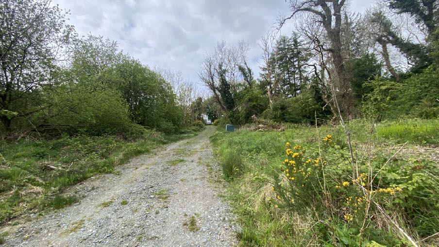
1.2 Vehicular access is via an unmade lane and field gate opposite the front boundary of the property, Tillyloss. It is understood that work has been undertaken in the vicinity of the access by Manx Utilities in connection with the water main which passes through the site, which has resulted in the lane being well maintained and accessible.
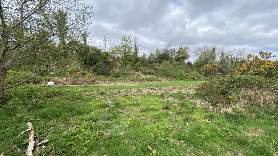
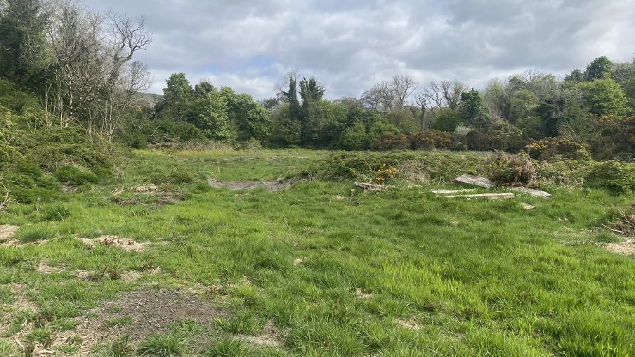
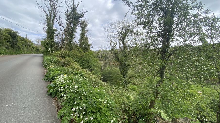
1.3 At the lower end of the lane as the land levels out to a wide plateau containing a range of trees, naturalised vegetation (ferns, gorse, grass) which has been partly cleared (outside of the bird breeding season).
1.4 The site overall falls into different habitat areas: grass and scrub with broadleaved trees generally sit to the north of the access and on the eastern side of the river to the south of this. There is also a small area of closed broad-leafed woodland immediately around the access and a further area at the southern boundary of the site.
1.5 The roadside is largely formed by ash trees, many of which are struggling with ash die-back and need to be managed, including felling where appropriate, irrespective of any
application. Other trees which are leaning into the site will be left undisturbed and if they fall into the site, this will be managed in due course.
1.6 Within the site there is also an area of gorse/broadleaved and coniferous trees, there are open areas of permanent pasture the most recent active use of which has been grazing by cattle and two areas of coniferous plantation. Cumulatively the area provides a breadth of habitat which has been investigated and has revealed a great amount of different species which has established through lack of human intervention. This naturalisation has, however, resulted in some parts of the site becoming overgrown with bracken and brambles without opportunities for flower meadows to become established.
2.0 The proposal
2.1 Proposed is the installation of two containers with roof link between to provide secure storage in connection with the management of the site. The applicant is in the process of the “re-wilding” of the site: using minimal intervention the owner aims to let nature take charge in creating and restoring habitats within the landscape, thereby promoting sustainable wildlife diversification and resilience. Renscault Brooghs were established on 28th May, 2021 and the site was the first to receive grant assistance under a Management Agreement of Section 30 of the Wildlife Act 1990 to a private organisation on land which is not a SSSI, registered nature reserve or working farm for biodiversity where the applicant was not an agricultural operation or commercial operation. This was a 5-year management agreement which provides a one-off grant to erect 272m of fencing to enable grazing for nature conservation, plus a small annual supplement. The Agreement aims to enable grazing to conserve and enhance the species rich semi improved neutral grassland whilst maintaining the bordering broadleaved tree cover and scrub which is part of he Renscault and Ballachink (West Baldwin) Bird Sanctuary.
2.2 The objectives of the management covered by this agreement is to enable the protection and enhancement of the existing natural and semi-natural habitats and their plant, fungi and animal communities. Specifically to maintain the diverse grassland flora, as an example of a scarce and declining vegetation type, to maintain the field as a grazed species-rich grassland, without agricultural improvement. Also, to prevent the loss of neutral grassland to bracken and gorse scrub by enabling a grazing regime.
2.3 Ecological surveys have been undertaken to establish the wildlife which is present on the site including a botanical species sheet comprising over 140 records so that management can protect and enhance these habitats and appropriate practices be engaged. Information on the site can be found at renscault.im.
2.4 This management requires the use of machinery and equipment which the applicant would wish to keep on site including a tractor and machinery and tools to manage the bracken and brambles as well as somewhere dry to keep and make the notes and records relating to the site and its re-wildling. It is the applicant’s longer term plan to enable the site to potentially provide education relating to the management and ecology of the site but this is not part of this application. One container will be used for housing the tractor and attachments needed to manage the vegetation and lift materials. The other will accommodate the hand tools including power tools (chain saws and brush cutters for
example) and for any equipment needed in association with the bee hives (spare supers, floors etc). It is proposed to provide a small area of roofing between the containers to store a small trailer and other materials which do not need to be secured. These materials and equipment are not used anywhere else.
2.5 This application proposes the installation of two containers on the western side of the plateau, generally out of site from the highway which is higher than the site and separated therefrom by a small field which is not in the same ownership. The existing trees on the site are all self seeded and it is proposed to take seeds from the existing trees this year, propagate them and re-plant around the site where there is space and if and where trees are removed due to their condition.
2.6 The containers will be finished in a dark green colour to minimise their visual impact although they will only be visible from within the site due to the topography and intervening trees and natural vegetation.
2.7 There is no intention to invite others to the site and therefore no requirement or intention to create car parking, manoeuvring or other areas or activity. The vehicles associated with those visiting the site can be parked safely at the lay-by at the top of the lane.
3.0 Planning status
3.1 the site is not designated for a particular purpose on the Area Plan for the East (2020). There is a bird sanctuary which incorporates part of this site. There are Registered Trees on the site according to the Government mapping (RA1512) although it is understood that this designation has been removed in order to manage the woodland effectively.
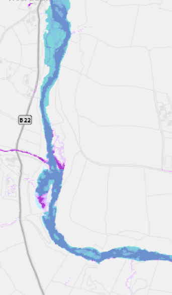
3.2 There are areas adjacent to the River which are shown as being at risk of river flooding on the national flood risk maps. The site of the proposed containers is understood to sit just outside this blue area.
3.3 There are no buildings on the site, no Registered Buildings and the site does not lie within an adopted or proposed Conservation Area.
3.4 As the site is not designated for development, there is a presumption against development here as set out in General Policy 3 of the Strategic Plan which sets our
exceptions which include “f. building and engineering operations which are essential for the conduct of agriculture or forestry” and “h. buildings or works required for interpretation of the countryside, its wildlife or heritage”.
3.5 In 2008 the Department commissioned a study of the Island in terms of its types of landscape. The Area Plan has adopted the findings of this study, the full section which refers to this site and surrounding area, is included at Appendix One. It is summarised in the Area Plan as follows:
“Landscape Strategy:
Conserve and enhance:
a) the character, quality and distinctiveness of the valley with its dense deciduous woodland in lower valley bottom;
b) the traditional character of West Baldwin Village;
c) the rural and tranquil character of the valley;
d) the open views across the West Baldwin reservoir to the surrounding upland areas”.
Key views: Enclosed views from the valley bottom Glimpsed views between vegetation up the valley to the upland areas. Open views across the West Baldwin Reservoir. Glimpsed view of St. Luke’s Church."
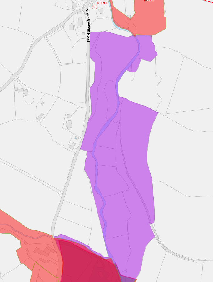
3.6 The ecological and arboricultural importance is also noted on the Area Plan Environmental Constraints Map 1a below. On this map, the purple colouring which includes all of the site, denotes the Renscault and Ballachrink Bird Sanctuary which was designated in 1978 with Registered Trees to the north and south of the site.
3.7 The Strategic Plan policies which are relevant here, in addition to General Policy 3 include:
Environment Policy 1 which protects the countryside for its own sake
A site location map showing a large purple highlighted area along West Ballwyn Road with surrounding field boundaries and building footprints.
Environment Policy 3 which protects trees, particularly ancient, natural and semi-natural woodlands which have public amenity or conservation value. Environment Policies 4 and 7 which protect ecology Environment Policies 10 and 13 which protect sites and adjacent areas from flood risk Environment Policy 15 provides advice on agricultural and horticultural development Environment Policy 22 protects the environment and amenity of nearby properties from noise, pollution, light, vibration or odour nuisance
4.0 Planning history
4.1 The site has been the subject of an application submitted by the then owner, Department of Environment, Food and Agriculture, which was approved for the change of use of the area to public open space (05/00118/C). Planning approval was sought and withdrawn for the principle of the erection of two dwellings (05/92423/A) which attracted concerns regarding the impact of flood risk, on ecology, access and the water main which runs through the site. 96/01463/B saw approval granted for the reinstatement of the access.
4.2 Applications have been approved around the Island to facilitate understanding and enhancing wildlife: 18/01269/B saw approval granted to the erection of a building for use as a bird hide and education centre at Langness. 18/00904/B saw approval granted for the erection of a log cabin for the storage and making up or bee keeping equipment. 15/00226/B was approved for a timber shed for use for bee keeping purposes.
5.0 Issues
5.1 Whilst the site is not designated for development on the Area Plan, there is provision in the Strategic Plan for development to be approved where this is necessary and in association with agriculture, forestry and for the interpretation of the countryside, its wildlife or heritage. In this case, the site is not just woodland but it has a woodland setting with associated areas of scrub, pasture, river and grass which cumulatively make up the woodland setting and habitat.
5.2 The management of the site as it is re-wilded will involve the use of machinery to cut back the invasive gorse and ferns at the appropriate time of year, maintain fencing to ensure that the cattle brought in to graze remain within the appropriate parts of the site, the use of a tractor... As the site has no on site living accommodation or supervision, the applicant would like his equipment to be secure and out of the weather. As such, we would submit that the containers are necessary for the agriculture and forestry purposes set out in General Policy
3 and thus complies with that policy.
5.3 The work which will be facilitated by the storage of the equipment and facilities on the site will support the objectives of Environment Policies 1, 4 and 7 in restoring the natural habitat of the site in the interests of both the wildlife of the site and the character of the site and the surrounding area. This also complements the protection and enhancement afforded by the bird sanctuary abutting the site to the south.
5.4 The containers will be sited so that it will not be seen by the public and coloured so that it blends into its background when viewed from within the site. It is positioned such that it is just outside or certainly at the perimeter of the area of flood risk from the river and the container will have no electricity supply or water sensitive equipment within: if there is, this will be stored at a higher level within the containers. The nature of the vegetation around the area where the containers are to be sited would suggest that any flood water in the past has not reached this area and the reeds are closer to the river than the proposed site.
5.5 The Strategic Aim states the objective:
To plan for the efficient and effective provision of services and infrastructure and to direct and control development and the use of land to meet the community’s needs, having particular regard to the principles of sustainability whilst at the same time
preserving, protecting, and improving the quality of the environment, having particular regard to our uniquely Manx natural, wildlife, cultural and built heritage.
5.6 What is proposed will re-create a natural and sustainable environment for the benefit of wildlife and biodiversity, supporting this policy and supporting the Wildlife Act 1990. The structures are not permanent so if the proposed use ceases, the containers could be removed and the site restored to its present condition. A planning condition could be attached to any approval to this effect.
5.7 Similarly, Strategic Policy 4 states:
Proposals for development must:
(a) Protect or enhance the fabric and setting of Ancient Monuments, Registered Buildings(1), Conservation Areas(2) , buildings and structures within National Heritage Areas and sites of archaeological interest;
(b) protect or enhance the landscape quality and nature conservation value of urban as well as rural areas but especially in respect to development adjacent to Areas of Special Scientific Interest and other designations; and
(c) not cause or lead to unacceptable environmental pollution or disturbance.
5.8 The proposal will have no adverse impact on the character, appearance or ecology of the area in accordance with the Landscape Character Assessment Strategy within the Area Plan for the East and Environment Policy 1 and will assist in the rewilding and biodiversity enhancement of the site in accordance with General Policy 3b and h and Environment Policy 1.
Sarah Corlett 10.07.25
APPENDIX ONE
EXCERPT FROM THE LANDSCAPE CHARACTER ASSESSMENT, 2008 B7 – WEST BALDWIN Key Characteristics
• Steep sided V-shaped valley.
• Various smaller tributaries.
• Dense deciduous woodland in valley bottom.
• West Baldwin Reservoir and associated features.
• Coniferous plantations.
• Heathland vegetation on steeper slopes upstream.
• Strong geometric field pattern on valley slopes downstream.
• Narrow sometimes steep B22 road with Manx hedges, mature trees and stone walls lining its path around the reservoir.
• Scattered whitewashed houses along valley bottom road.
• Traditional small settlement of West Baldwin at a river crossing point near the mouth of the valley.
• Remote rural and tranquil feel, bolstered by the surrounding open expanse of the upland areas and large expanse of water at West Baldwin Reservoir.
• Enclosed views from the valley bottom with more open views further up the valley to the surrounding upland areas.
• Ard Whallin Outdoor Pursuits Centre, which provides fishing/sailing facilities.
Overall Character Description The River Glass descends from the upland area below Injebreck Hill and Carraghan down into the Incised Inland Slopes north of the settlement of Baldwin and has cut a steep sided V-shaped valley along its course. Tributaries of a variety of sizes, including that in the relatively large wooded Awin ny Darragh Valley, the steep sided Colden River and smaller water bodies in culverts, join the valley at various points along its course. The Colden River is surrounded by the Colden coniferous plantation.
Dense deciduous woodland covers much of the valley bottom in the lower part of this valley with grazing paddocks, wet meadows and lush riparian vegetation alongside the river. Rectangular pastoral fields, on the gentler valley sides of the lower valley, peter out
upstream as the field patterns fragment and large, blocky coniferous plantations, rough grass, areas of bracken and gorse grow on the steeper slopes that ascend to the Upland areas.
The road corridor is enclosed by grassy Manx hedges and mature hedgerow trees, while Manx hedges with gorse form the majority of the field boundaries on the valley sides lower down the valley. Field boundaries are overgrown or lost in the upper reaches of the valley. A mature avenue of beech trees lines the road around the estate of Injebreck House.
Various houses and many that contain ornamental garden species that have a whitewash render or are built of Manx slate stone are clustered along the valley bottom road. Stone bridges cross the B22 at West Baldwin while some farms with associated outbuildings, such as Ballakewish, are located on the valley slopes and surrounded by deciduous trees.
The extensive West Baldwin Reservoir is dammed with a graded grass slope to the south, has peripheral slate stone walls alongside the B22 and has its eastern periphery fringed by mature waterside trees. This large expanse of water, the lack of substantial settlement in the area and the expanse of the surrounding uplands create a relatively remote and tranquil character. This sense of tranquillity can be interrupted at times by parked vehicles, traffic and other activity associated with recreational uses on or near the reservoir.
Key Views
• Enclosed views from the valley bottom
• Glimpsed views between vegetation up the valley to the upland areas
• Open views across the West Baldwin Reservoir
• Glimpsed view of St. Luke’s Church
Historic Features
• Turn of the century Manx Slate stone houses in Baldwin
• Disused quarry
• Monument marking original site of Tynwald Hill
• Site of St. Luke’s Church (Registered Building)
Ecological Features
• Aquatic and waterside habitats
• Upland heather moorland habitats
• Marginal farmland habitats
• Hedgerows with high biodiversity
Evaluation of landscape sensitivities
• Dense mature deciduous woodland along the valley bottom and lower slopes.
• Remote, rural and tranquil character.
• Strong regular pastoral field patterns on lower slopes.
• With exception of traditional nucleated village of West Baldwin, sparse settlement in the valley.
• Dense riverside woodland and vegetation.
• Ecological value of the aquatic ecosystem of the West Baldwin Reservoir and riparian habitats.
• B22 enclosed by grassed Manx hedges with vegetation and overhanging trees growing on top in some sections.
Landscape Strategy The overall strategy for the area should be to conserve and enhance the character, quality and distinctiveness of the valley with its dense deciduous woodland in lower valley bottom, the traditional character of West Baldwin Village, the rural and tranquil character of the valley and the open views across the West Baldwin Reservoir to the surrounding upland areas.
Copyright in submitted documents remains with their authors. Request removal