4.0 OPTION DEVELOPMENT ....................................................................................................................6
5.0 CONCLUSION..........................................................................................................................................7 APPENDIX A – EXTENT OF WORKS & DETAIL OF ARTWORK...........................................................8
1.0 Introduction
1.1. In 2014 Jeremy Benn Associates Limited (JBA Consulting) were commissioned by the Department of Infrastructure Highway Services to develop a number of technically viable concept solutions to address still water level flooding in harbour environments and wave overtopping in open coast environments, at seven harbour and coastal sites across the Isle of Man. The seven sites were Castletown, Douglas, Laxey, Ramsey, Peel, Port St Mary and Gansey.
1.2. The primary aim of this study was to undertake an investigation to develop a number of concept solutions to reduce the risk posed by coastal processes to the existing coastal and harbour defences at the seven sites named above. Within each of the seven sites, the risk mechanism can be split into two primary risks, the still water level flood risk and the wave overtopping risk. These two risk mechanisms are broadly defined as:-
Still water level (SWL) flooding occurs when the water level exceeds the defence crest level and water inundates the hinterland.
Wave overtopping occurs when waves run up the face of the coastal defence. Where the wave run up exceeds the defence crest level, water will pass over the defence and inundate the hinterland.
1.3. The purpose of this statement of case is to provide a summary of the design proposed for the construction of a wall to protect against wave overtopping along a 500m section of Douglas promenade. It is likely that in the future that this project will form part of the overall climatic change for Douglas promenade to assist with the prevention of still water flooding and wave overtopping.
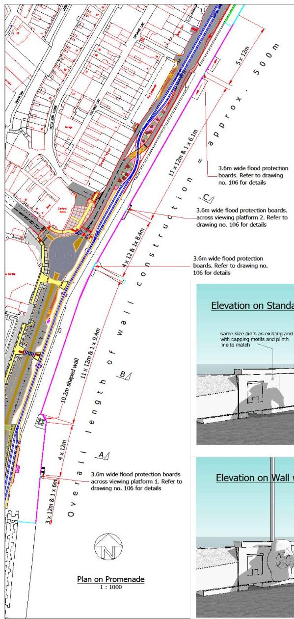
1.4. The project will involve the construction of a wave overtopping wall along a 500m section of Douglas promenade. The wall will offer localised protection to the horse tram operation against wave overtopping in the area of the war memorial, which is set to become a tram turning area on the new Douglas promenade. The construction of the wall will be the first part of the promenade improvement work. See Appendix A for the extents of this work and conceptual Ideas.
1.5. The construction of the wall will consist of a reinforced concrete wall tied into the top of the existing concrete sea wall. The wall will run between the end of the Sunken Gardens and The Empress Hotel and will incorporate architectural features to soften its visual impact.
1.6. At 1.2m high the wall will allow people to see over the top and out to sea. This height is not the full height that will be required if climate change continues as expected but it has been designed so that an additional 0.6m can be added by future generations when required. It is anticipated that the wall will eventually be extended the full length of the promenade; however this scheme is only for wave overtopping for the limited section as described above.
1.7. Subject to planning approval it is proposed to start construction of the wall in October 2018. It is anticipated that the construction programme will be approximately four months and disruption to the public is expected to be minimal.
2.0 Environmental Assessment
2.1 In December 2014, JBA were commissioned to carry out an environmental scoping study to identify potential significant environmental effects associated with the conceptual coastal and harbour defence options for the Isle of Man. This report covered the following aspects for Douglas open coast:-
Identifies the existing key baseline environmental conditions.
Appraises the potential significant environmental effects of the defence options on notable environmental features.
Sets out the scope of environmental assessment work required.
Identifies the organisations that would need to be consulted with to inform the detailed design phase.
Landscape and visual impact assessment.
Heritage assessment.
Assessment of potential for contaminated land.
Coastal ecological assessment.
Hydromorphology assessment.
3.0 Planning Policy
3.1 Isle of Man Strategic Plan 2016 The most relevant policies relating to the sea wall are:
a. Spatial Policy 6: Douglas Harbour will be protected and enhanced.
b. General Policy 2: Development in areas zoned for development.
c. Environmental Policy 10: Site at risk of flooding will require a flood risk assessment.
d. Environmental Policy 11: Limitations on coastal defence.
e. Environmental Policy 12: Visual impact on the character, appearance and ecology.
f. Environmental Policy 24: Requirement for an Environmental impact assessment.
g. Environment Policy 35: Relates to development within Conservation Areas.
h. Recreation Policy 2: No loss of open space .
i. Transport Policy 13: Not detrimental to character of harbour or historic interest.
j. Appendix 4: Guide for a flood risk assessment.
k. Appendix 5: Guide for an environmental impact assessment.
3.2 Various consultations have been held with planning officers from DEFA and reference has been made to the above planning policies extracted from the 2016 strategic plan to assist with the formation of the planning application and also to assist with understanding the level of information required in the application.
3.3 In preparing the planning application for this project consideration has been given to the promenade as a designated public open space on the Douglas local plan 1998 and also how it sits within the Douglas promenades conservation area 2002. The visual aspect of how it will look has been considered in conjunction with environment policy 2012 as well as the proposed wall is within the conservation area. The appearance of the wall and associated flood gates have been assessed on whether it preserves or enhances the character of the area (Environment Policy 35). The flood risk assessment that has already been carried out supports the environment policy 10 requirements and environmental impact assessment (Environment Policy 24).
4.0 Option Development
4.1 Generally for the climatic change projects for the Island’s town and harbour environments subject to still water level flood risk the options typically fall into three main categories namely:-
Raised harbour walls
Set back walls
Tidal gates
4.2 For the open coast options, subject to both still water level and wave overtopping flood risk the suitable options include:-
Raised sea walls
Set back walls
Permeable revetments
Beach recharge
For this project and for the purposes of this statement of case the only viable option
considered for the purpose of providing a wave overtopping reduction wall was to raise the existing sea wall for this section of wall under consideration
4.3 The original planning application raised a number of concerns from the planners and Douglas Corporation. In order to mitigate these concerns the following additional information and changes have been made to the application:-
Additional artwork has now been incorporated into the wall
A provision for locating the existing flag poles and life rings on the wall has been made
Two viewing areas have been provided to allow access for wheelchair users
A vehicle beach access has been provided at the bottom of Broadway
An Environmental Impact Assessment has now been provided that includes a Heritage Impact Assessment, and a statement regarding any Flood Risks.
5.0 Conclusion This statement of case accompanies a planning application for the Douglas Promenade Waver Overtopping Reduction Wall. The Department has tried to balance a number of key factors with this planning application: improving community protection and resilience when there is a risk of wave overtopping, engineering practicalities and aesthetic impact.
Attention to detail and addressing such parameters as aesthetics, buildability and future maintainability has hopefully produced a scheme which will blend with the surrounding environment and yield acceptable levels of disruption to the public during the construction stage.
Appendix A – Extent of Works & Detail of Artwork
Technical engineering drawing showing a plan view and elevations for a 500m long coastal sea wall construction project.
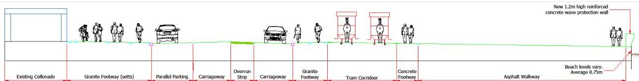
SECTION A - A
A technical cross-section drawing of a coastal promenade showing existing infrastructure like footways and carriageways alongside a proposed 1.2m high reinforced concrete wave protection wall.
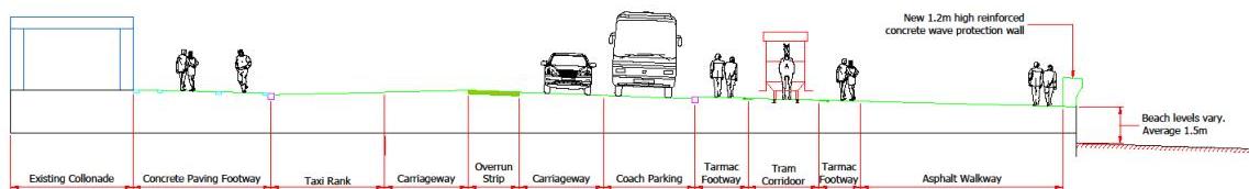
SECTION B - B
This technical drawing shows a cross-section of a coastal promenade, detailing the existing infrastructure like footways and carriageways. It highlights the proposed location and height of a new 1.2m reinforced concrete wave protection wall.
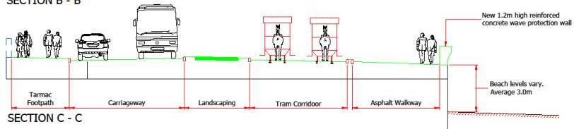
SECTION C - C
Technical cross-section drawing illustrating the proposed 1.2m high reinforced concrete wave protection wall along a coastal promenade with tram and road corridors.
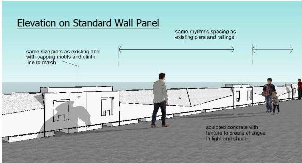
Elevation on Standard Wall Panel
An architectural elevation drawing illustrating a proposed reinforced concrete sea wall panel design with annotations on piers and texture.
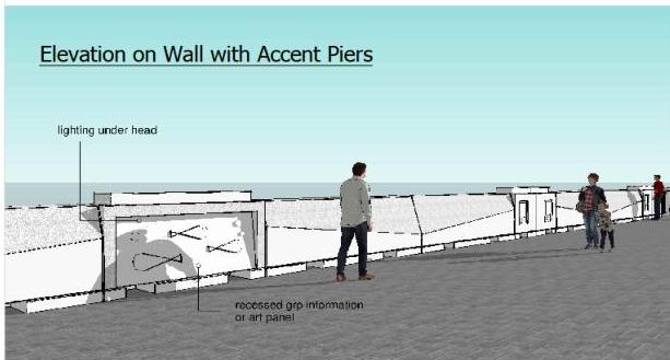
Elevation on Wall with Flagpole and Lifering
Architectural elevation drawing showing a proposed sea wall design with accent piers, lighting, and people for scale.
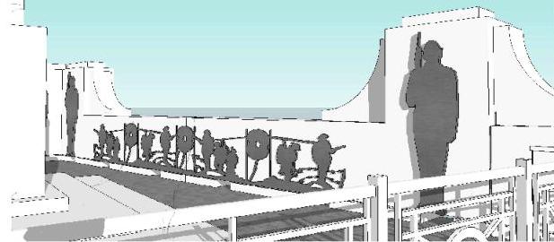
Detail of War Memorial with Bronze Images
P Planning
A 3D rendering or elevation drawing depicting a proposed sea wall design featuring silhouettes of soldiers and cannons along a coastal promenade.
Infrastructure
San-treggalpa
Elevation
Efficiencies, Resources, Resources Disparities and all dedicated houses have been found in the following
Table of files:
2011, 2017
C/Boon (Highway)
1st File
Douglas Promenade Wave
Overtopping Reduction Wall
During File
Site Plan and
Proposed Outlook
Copyright in submitted documents remains with their authors. Request removal