Loading document...
| Property ID: | 3 Bridge Street |
| Owner/Tenant occupied: | Owner |
| Owner name: | Mr & Mrs Bates |
| Owner address (if different to above): | N/A |
| Type of property: | Mid Terrace |
| Foul drainage system: | Public sewer |
| Has the property been affected by flooding (including curtilage)? | No |
| Flood protection survey date: | 10th January 2018 |
| Surveyed by: | C Lucas & M Harvey |

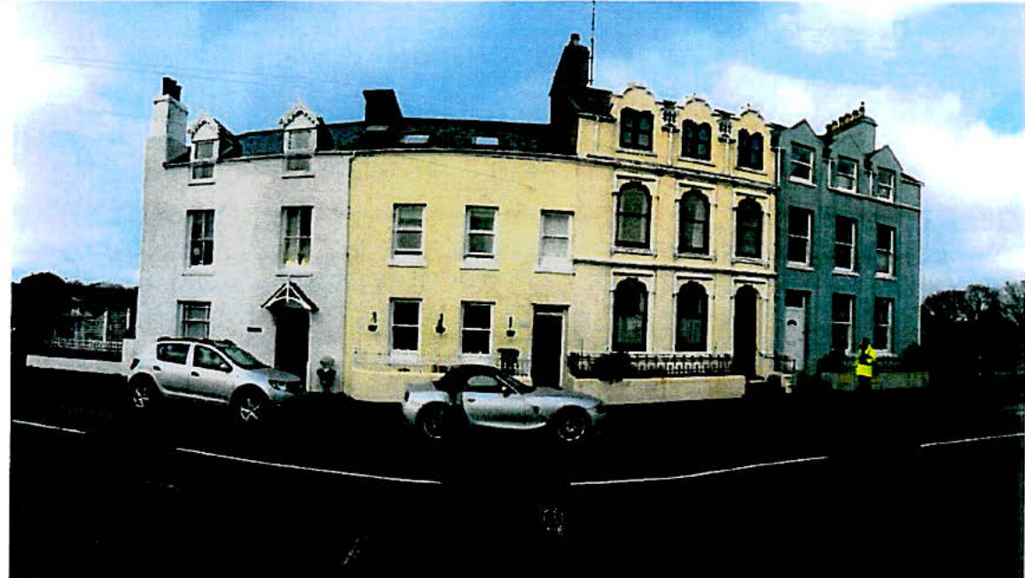
01, 03, 05, 07 Bridge Street (Number 03 is second from the left)
JBA Consulting
It should be noted that it is not possible to completely prevent flooding. Flood resilience and resistance measures are designed to mitigate flood risk and reduce damage and adverse consequences. They will help you to recover more quickly following a flood event. Any alterations conducted to the property after the installation of flood protection measures may lead to barriers no longer being able to be installed or to protect the property as designed and/or may create routes for water to bypass the measures installed. Flood resilience and resistance measures are explained further in sections 1.2,7 and 8 of this report. It is very important that you prepare your emergency flood plan, documenting the actions to be taken if there is a risk of flooding. These should also address any residual flood risk remaining once any measures have been deployed. It is important to recognise that flood protection measures can be overwhelmed by a bigger flood event. Information on preparing a personal flood plan is provided in section 10.2. Please refer to the Isle of Man Government website for further information: https://www.gov.im/transport/floodwatch/floodprepare.xml
Flood resistance measures aim to reduce the amount of floodwater entering the property, such as door barriers and automatic airbricks. Flood resilience measures aim to reduce the damage caused by floodwater which has entered the property, such as tiled floors and raised electricity sockets. Annual Exceedance Probability (AEP): The likelihood of a flood happening is best described as the chance or probability of a particular flood occurring in any one year. For example, "there is a 1 in 100 chance of flooding in any given year." This is usually described as a annual exceedance probability (AEP) flood. Metres above Ordnance Datum (mAOD): Frequently used to record and compare river levels and the relative height of objects above the mean sea level.
This report presents the findings from the survey of number 3, Bridge Street, Castletown, Isle of Man and outlines the core package of flood resilience and resistance measures which may be considered appropriate for this property. The property survey was restricted to such locations as were reasonably apparent by inspection from ground level from both inside and outside the property. No excavations were made to try to locate other entry points.

JBA Containing
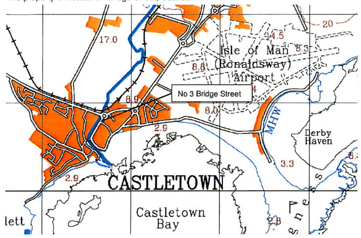
The property is located on Bridge Street, Castletown.
The property is a mid-terraced constructed in the 1860's. Where visible, the stonework and mortar is in good condition. The house has been rendered and painted so stonework and pointing is not visible. The ground floor is formed in concrete, however, condition of the flooring assumed to be good but was not inspected at the time of the survey. The property historically had a rear yard, similar to number 5, however, sometime in the 1990's the property was extended at the rear, filling the yard. In addition, the building has had a balcony added to the rear extension. This balcony over hangs the Silverburn River. The balcony is approximately 2300 mm above bed level. The homeowner also reported the property historically having a cellar, however, he reported this was filled in as part of the extension works in the 1990's. The house is situated on the left bank of the Silverburn River. The external wall is constructed on top of the river's retaining wall.

The geology of the surrounding area is defined as Sandstone from the Santon Member of the Lonan Formation.
These sedimentary rocks are permeable and allow for the storage and movement of groundwater. The bedrock is overlain by superficial deposits of sand and gravel formed up to 2 million years ago during the Quaternary Period.
| Flood Event | Reported Internal Flood Depth (mm) | Reported External Flood Depth (mm) | Ingress Route(s) |
|---|---|---|---|
| 01/2014 | 0 | Threshold level at front door | N/A |

The homeowner reported that flood water has never entered the property, however, it has come close to threshold level at the front and rear on a several occasions, most notably in the January of 2014. The river level rose to the balcony level which is situated at the rear of the property overhanging the Silverburn River and is approximately 2300mm above bed level. At the front of the property on the same event water came close to exceeding the front threshold level. The front threshold is approximately 190mm above ground level. At the front of the property there is a wall containing a raised flower bed under the front window. It is also reported that the internal wall looked and felt damp in the corner of the room where the wall ties into the front of the house. According to the homeowner this is the only section flood water ponds against the house because the front wall holds water off the property. Since this flood event the home owner has constructed and installed a make shift demountable flood barrier at the front gate.
The homeowner reported that currently there is no flood warning service on the Isle of Man
Modelled flood depths are not currently available for use in this report. Manx Utilities Flood Map shows that this property is at High Risk of River and Tidal flooding. The risk of surface water flooding to the property is unknown, although surface water flooding has not been reported as an issue.
The following table displays reported flood events and depths at this property.
The global average surface temperature has increased since the late 19th century. Further warming is unavoidable and is being enhanced by human activities. This warming has changed, and will continue to change the water cycle and sea levels, with sea levels predicted to continue to rise beyond 2100.
The property is situated on the left bank of the Silverburn River.
The Manx Utilities Flood Map shows the property has a high chance of River and Tidal flooding in any year. The Flood Map indicates the extent of river flooding associated with a flood event having a 1% chance of occurring in any year and the extent of coastal flooding for the extreme sea level having a 0.5% chance of occurring in any year. https://www.manxutilities.im/media/1520/silverburn_subset_-1.pdf

High levels of precipitation increase the likelihood of surface water flooding. The risk of surface water flooding to the property is unknown.
Please note that surface water issues have the potential to be exacerbated by poorly functioning surface water drains.
Surface water flooding will tend to follow road levels resulting in relatively shallow depths of flooding when compared to fluvial and tidal depths.
There are no groundwater level measurements available within the vicinity of the site. However, with increased precipitation, groundwater levels will rise, which could result in groundwater entering the property directly through the property floors, and an increased level of surface water overland flow. The property is known to flood.
The property may be at risk of flooding from foul drainage becoming inundated, causing sewage to back up into the property. There have been no reports of poorly functioning drains, or sewage backing up into the property and the property has no toilet on the ground floor.
Copyright in submitted documents remains with their authors. Request removal
View as Markdown