Loading document...
| PLANNING COMMITTEE SECRETARY'S OFFICE |
| 11 AUG 1998 |
| 980889 |
| REF. ... |
August 1998
Sea Terminal Building Douglas Isle of Man IM1 2RF
Telephone (01624) 686600 Fax (01624) 686970 Email [email protected]
| CHAPTER 1 | INTRODUCTION | PAGE NO |
|---|---|---|
| 1.1 Purpose | 1 | |
| 1.2 Area of concern | 1 | |
| 1.3 Background | 1 | |
| CHAPTER 2 | WHY AN IMPROVEMENT IS NECESSARY | |
| 2.1 General | 3 | |
| 2.2 Road Widths | 3 | |
| 2.3 Road Visibility | 3 | |
| 2.4 Retaining Wall Stability | 3 | |
| 2.5 Traffic Volumes | 6 | |
| 2.6 Existing Use | 6 | |
| 2.7 Future Use | 6 | |
| 2.8 Carriageway Failure | 7 | |
| CHAPTER 3 | INITIAL OPTIONS CONSIDERED | |
| 3.1 Widening on the West side | 9 | |
| 3.2 New road on the East side | 11 | |
| 3.3 Widening on the East side | 13 | |
| 3.4 Conclusion on the initial designs | 14 | |
| CHAPTER 4 | A STUDY OF ALL AVAILABLE OPTIONS | |
| 4.1 Introduction | 15 | |
| 4.2 Options to be considered | 15 | |
| 4.3 Criteria used to judge options | 15 | |
| 4.4 Option 1 - Do nothing | 16 | |
| 4.5 Option 2 - Make road one-way | 17 | |
| 4.6 Option 3 - Make road one-way and restrict HGV’s | 19 | |
| 4.7 Option 4 - Retain two-way and restrict HGV’s | 21 | |
| 4.8 Option 5 - Alternative routes | 21 | |
| 4.9 Option 6 - Widen existing road | 23 | |
| CHAPTER 5 | FURTHER STUDY - WIDENING EAST SIDE | |
| 5.1 Option A - Minimum Improvement Scheme | 27 | |
| 5.2 Option B - Medium Improvement Scheme | 29 | |
| 5.3 Option C - Full Improvement Scheme | 31 | |
| 5.4 Summary of widening options | 32 | |
| 5.5 Conclusion | 32 | |
| CHAPTER 6 | POTENTIAL IMPACTS OF THE CHOSEN SCHEME | |
| 6.1 General | 33 | |
| 6.2 Impact on the flora | 33 | |
| 6.3 Impact on the bird life | 33 | |
| 6.4 Impact on bat life | 34 | |
| 6.5 Impact on invertebrates | 34 | |
| CHAPTER 7 | SUMMARY/CONCLUSION |
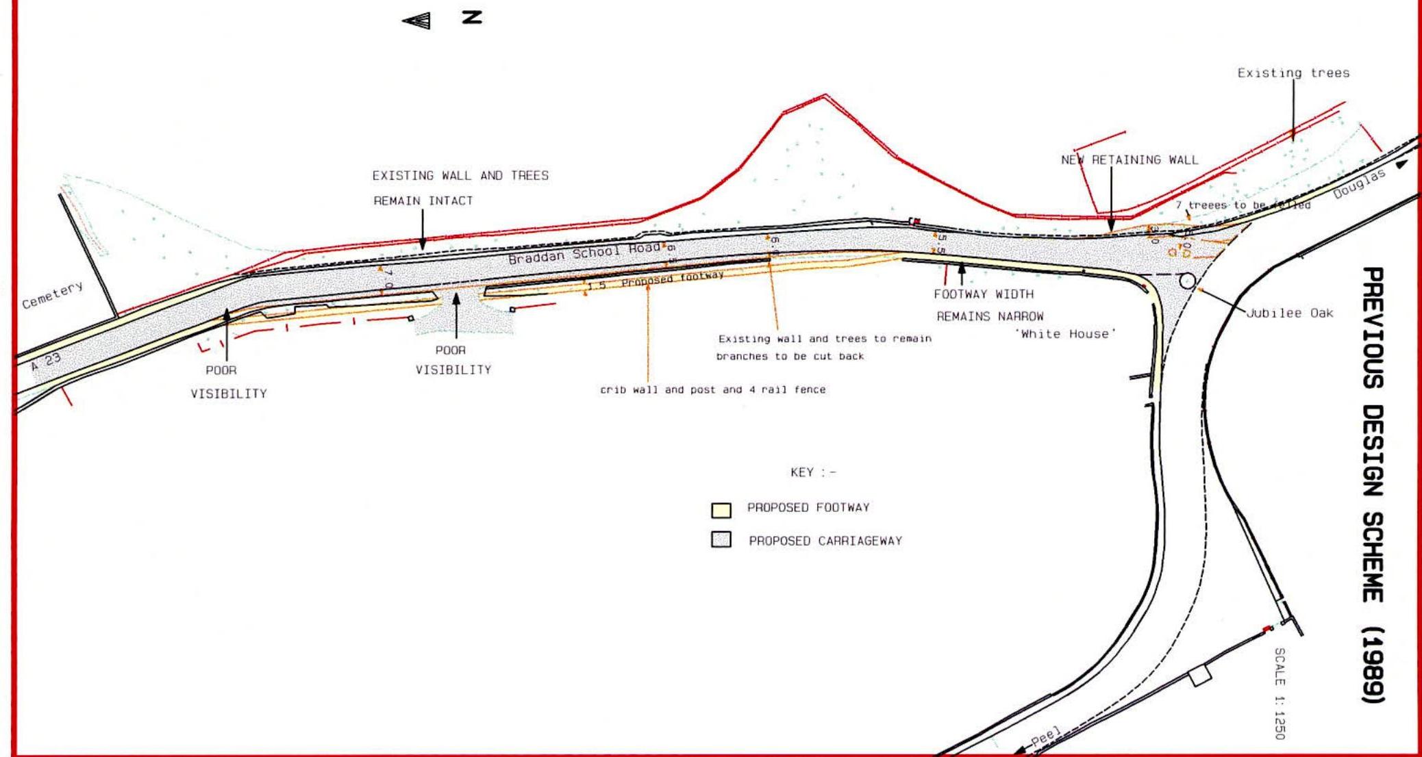
PREVIOUS DESIGN SCHEME (1989)
SCALE 1: 1250
CHAPTER 1 INTRODUCTION
The purpose of this document is to explain the development of the proposed road improvement scheme.
Its aim is to show why an improvement scheme is necessary and how the proposed scheme satisfies more fully the requirements of the Department of Transport, and the Isle of Man in general.
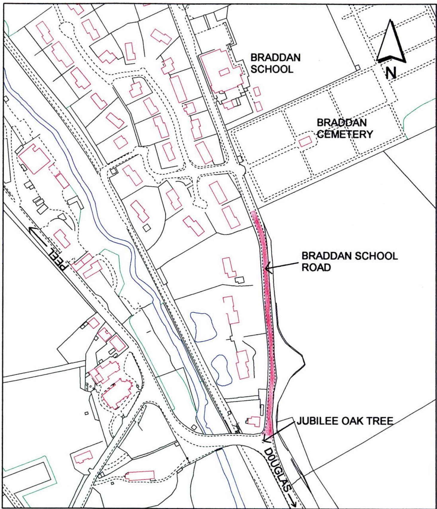
The section of road under consideration is from Braddan Cemetery to its junction with Peel Road, a length of approximately 260 metres, and is shown opposite.
This section of road is bounded on the East side by a Manx stone retaining wall, behind which are many mature trees, leading upwards to a steeply sloping field.
To the West, there is a footway adjacent to the road and an incomplete Manx stone wall with several trees and shrubs. Residential properties are situated on steeply sloping land behind the Western Manx stone wall, below the level of the road. This road, the A23, is classified as a primary distributor road, and is a designated road as approved by Tynwald.
It has long been the intention of this Department to improve this section of road. As early as 1989 an improvement scheme was designed (see following page).
The scheme involved widening the road by taking the existing footway into the carriageway, and constructing a new footway on the West side of the road, on the slope behind the existing hedge line.
Although planning permission for this scheme was granted in November 1989 it was decided that construction should not be carried out.
Although the scheme would have been an improvement on the existing situation approximately 80 metres of road would remain under 6.0 metres in width, 30 metres of which remaining only 5.5 metres in width.
In addition, because the existing road alignment remained unaltered, there was no improvement in stopping sight distance and junction visibility at the new housing development on the West side of the road.
CHAPTER 2 WHY AN IMPROVEMENT SCHEME IS NEEDED
Braddan School Road, in addition to being a designated route for heavy vehicles, is also the main route from Douglas to Tromode Industrial Estate, the Vehicle Test Centre, the existing Hospital, and housing developments.
The majority of this section of road has a width of 5.5 metres. There are several sections, totalling about 50 metres in length where the width reduces to 4.8 metres, with a minimum width of 4.6 metres in one place.
This is well below the recommended width of 7.3m for this class of road. As a result, large vehicles often mount the footway in order to pass each other. This presents a major safety concern to pedestrians on the adjacent narrow footway.
The visibility (stopping sight Distance) on the bend approaching the Cemetery at 50m, is below that recommended for this class of road.
The absolute minimum value recommended for this class of road is 90m (TD9/93).
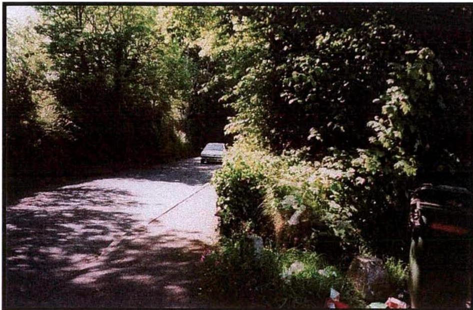
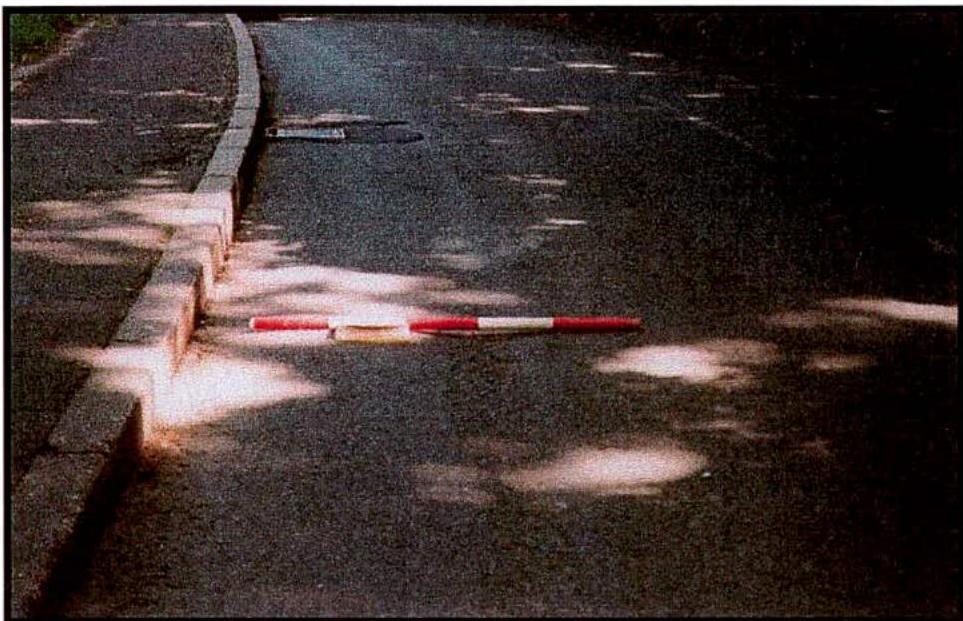
In addition the visibility at the entrance to the small development (looking South) is 19 metres, based on an absolute minimum x distance of 2.4 metres (i.e. the distance from the edge of the main road back along the centre line of the estate road).
Again this is well below the recommended value of 120m for this class of road (TD42/95). Plate 1 illustrates the poor visibility at this junction.
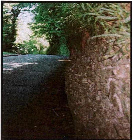
The existing masonry wall retaining on the East side of Braddan School Road bulges in parts and has collapsed in places in recent years.
Root systems from the trees behind the wall may have given some initial support to it, but they are now causing its failure.
Further collapse is likely to take place in the near future unless the wall is strengthened or rebuilt. Any such collapse could result in a danger to traffic and temporary closure of the road.
Following advice from DAFF it is believed that the wall cannot be replaced without damage to tree root systems and subsequent loss of adjacent tress.
Any strengthening of the wall would have to be carried out on the road side of the wall to avoid similar root damage, with a consequent reduction in road width.
Plate 2 illustrates severe bulging of the wall.
4 Z
EXISTING WALL AND TREES
Existing trees
EXISTING STONE WALL
FODTWAY WIDTH
IS NARROW AT 1.5m
"White House"
Jobilee Oak
4 Z
EXISTING WALL AND TREES
Existing trees
EXISTING STONE WALL
FODTWAY WIDTH
IS NARROW AT 1.5m
"White House"
Jobilee Oak
EXISTING FODTWAY EXISTING CARRIAGEWAY 6.00 ROAD WIDTHS {{image:573097}} EXISTING FODTWAY EXISTING CARRIAGEWAY 6.00 ROAD WIDTHS {{image:573097}}

PLATE1 - POOR VISIBILITY EXIT FROM ESTATE (SOUTH) PLATE2 - BULGING OF MANX STONE WALL
2.5 TRAFFIC VOLUMES Manual counts taken on Braddan School Road during the morning peak hour 8.00 a.m. to 9.00 a.m. Existing traffic flows have rapidly increased in the 5 year period between July 1992 and July 1997. This equates to a 65% increase in traffic. 2.6 EXISTING USE Braddan School Road is designated to carry heavy goods vehicles, long loads and is used for several bus routes. It is used as access to the residential areas of Braddan Bridge, River Heights, River Vale, River Walk and the Strang area. It is also used as access to Braddan Cemetery and as a major route to Braddan Primary School.
In addition it is also the main access to the Vehicle Testing Centre along Ballafletcher Road. Other potential routes to the Test Centre have weight restrictions which do not permit the passage of Heavy Goods Vehicles.
The road is classed as a 'primary distributor' and forms part of an outer link road linking new developments to existing and new residential areas in Douglas and Onchan.
2.7 FUTURE USE
Future traffic flows (even without the proposed new hospital) can be expected to increase.
This will result from completion of the Spring Valley Industrial Estate, the Isle of Man Business Park at Ballacottier, and Ballafletcher Industrial site.
In addition, from residential sites off Vicarage Road, Ballafletcher Road and Johnny Waterson's Lane, and migrating traffic from those avoiding queues through Douglas.
It is estimated that these developments will result in an annual increase in traffic of 2%, and that traffic generally is increasing due to increasing car ownership and island population growth, at a rate of 3% per annum.
Therefore in 2005, assuming a traffic growth of 5% per annum, traffic flow on Braddan Road during the morning peak could be 1000 vehicles per hour.
The existing road is suggested as having a maximum traffic carrying capacity of 1000 vehicles (TD20/85), with an acceptable environmental capacity of 500 vehicles per hour.
The existing road therefore already exceeds this environmental capacity and is likely to exceed the maximum capacity of the road by the year 2005.
The implication of the new hospital scheme on traffic volumes is that the maximum capacity of the existing road will be exceeded several years before the year 2005.
| 1992 | 1995 | 1997 | |
|---|---|---|---|
| Total no. of vehicles using section of road | 438 | 597 | 718 |
The undulating road surface indicates foundation failure. In addition a large depression across the road on the line of an old stone culvert indicates a probable culvert collapse.
Trial holes indicate an inadequate road construction for the traffic now using the road. The existing road construction thickness is only 300mm, consisting of 150mm of bitmac and 150mm of stone.
Recent heavy use of this road as a major diversion route, when bridge repair work was carried out at Union Mills, has added to the deterioration of the carriageway. The following photograph shows depressions in the road surface.
CHAPTER 3 INITIAL OPTIONS CONSIDERED
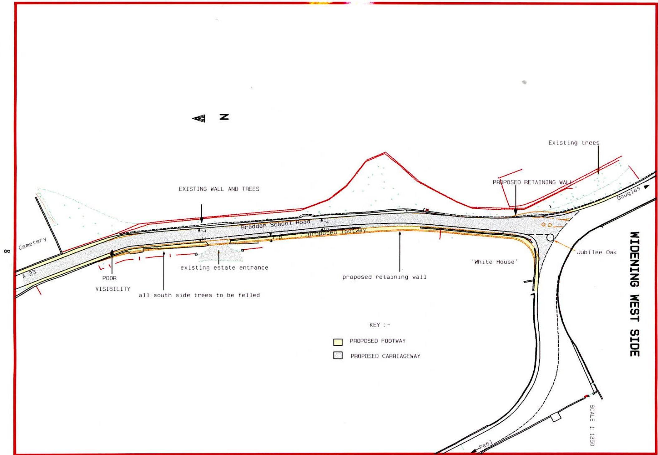
3.1 WIDENING ON THE WEST SIDE (see plan opposite)
This option takes the scheme designed in 1989 one step further. It involves widening the road on the West side to a width of 7.3 metres, and the removal of hedges and mature trees on this side of the road.
Land purchase would be required to enable the road widening and retaining wall to be constructed. This would move the road nearer to all adjacent properties and substantially reduce the frontage to the property opposite the jubilee oak tree.
Widening of the road on the West 'fill' side is likely to have a greater visual impact than on the East side (see Appendix A).
It is important that the tree line on this side of the road is strengthened not reduced in order to provide an effective screen to the adjacent properties, from the road.
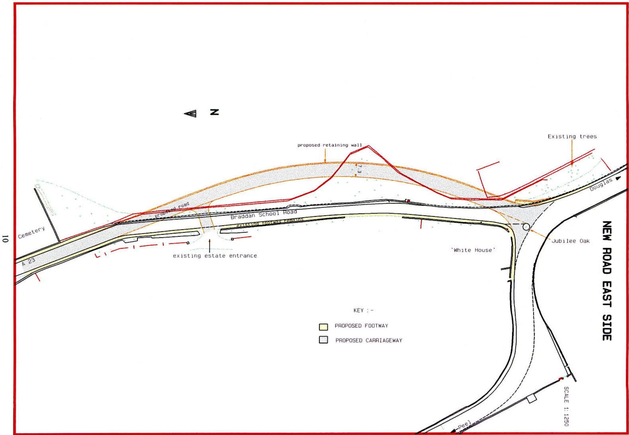
This involves the construction of a new road, 7.3 metres wide, off the line of the existing road, through land owned by the Drinkwater Estate.
This option involves the construction of retaining walls on both sides of the road. The total length of retaining wall will be 400 metres, at an average height of 5 metres (6 metres on the east and 4 metres on the west side).
In this scheme, some of the trees abutting the existing highway are retained, however this scheme still requires the felling of at least 25 mature trees.
The horizontal radius of 180 metres with a super elevation of 5% is below the absolute minimum required for the design speed of the road, and the longitudinal gradient of 1 in 10 over the lower 70 metres, is on the limit for heavy goods vehicle use.
To reduce this gradient it would be necessary to extend the road further into the hillside and create a new junction nearer to Quarterbridge.
This was considered to have too great a visual intrusion and environmental impact than the other alternatives.
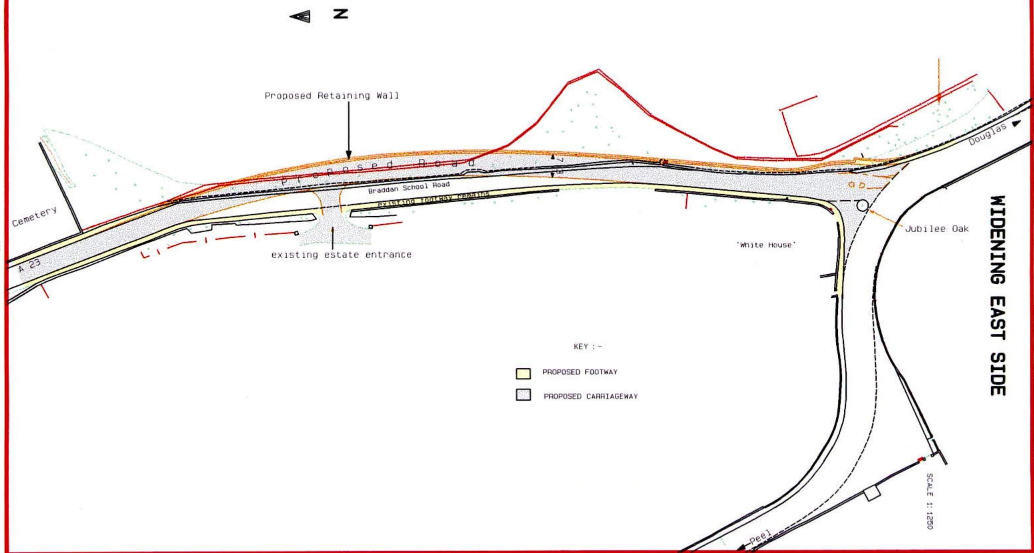
3.3 WIDENING ON THE EAST SIDE
This scheme involves the widening and realignment of the existing road on the East side by excavating into the adjoining land owned by the Drinkwater Estate.
This option requires the demolition of the existing Manx stone wall and between 35 to 45 mature trees on the East side of the road. Nineteen up to a possible twenty-three of these trees are classified as Grade A.
It involves the construction of a retaining wall on the East side over the majority of its length. The retaining wall will be 230 metres in length, varying in height between 2 metres and 4.5 metres, and faced in Manx stone.
The average gradient of the new alignment will be 1 in 19, with a maximum gradient of 1 in 12, similar to that of the existing road.
The horizontal radius of 260 metres at 7% Super elevation is the absolute minimum recommended for this design speed.
This option provides the best horizontal and vertical alignments of all the previous options. Stopping sight distance and visibility on the bend and at the small development is greatly improved.
The road is moved further away from all adjacent houses, and the footway is separated from the carriageway, thus improving pedestrian safety.
3.4 CONCLUSION ON THE INITIAL DESIGN
The problems associated with this lower section of Braddan School Road have been known for some time.
In 1989 a design scheme was produced that removed the severe pinch points. This received planning permission, however the scheme was, because of the constraints imposed on it, sub-standard, and therefore was not built.
The option 'widening the road on the east side', best meets the recommended standards for highway design.
It provides improvements in horizontal and vertical alignment and enables all to benefit. The road is moved further away from all adjacent properties, and access to the small development on the west side is much improved.
These options were considered and although widening on the east side was the preferred solution, it was decided that additional information was required on detailed traffic figures and likely environmental impact.
CHAPTER 4 A STUDY INTO ALL THE AVAILABLE OPTIONS
An environment assessment was carried out on the preferred scheme by Posford Duvivier and the additional information was considered. It was decided that a further study of all the available options should be undertaken, particularly with regard to the implications of re-routing Heavy Goods Vehicles through the town of Douglas, of using existing road infrastructure for an alternative route, and of the implications of a new route.
It was decided that the following options should be considered :-
In order to judge each of the options on an equal footing the following requirements have been established and grouped into two broad categories of safety and capacity.
Safety: Pedestrian and road traffic safety need to be improved to an acceptable standard. The retaining wall needs to be strengthened or replaced to prevent further collapse.
Capacity: Road capacity needs to be improved if this road is to continue to function as part of the link road. A full road reconstruction is required to continue with its existing use.
All options considered must meet these needs and be judged according to agreed criteria.
The agreed criteria in order of importance are as follows:-
15
4.4 OPTION 1 - DO NOTHING
If no improvements were made the safety of both pedestrians and road traffic would continue to deteriorate as the volume of traffic increases.
The instability of the existing retaining wall is likely to result in adjacent tree loss and continue to present a danger to traffic..
Braddan School Road is classified as a Primary and a 'Designated Road for Goods Vehicles'. Heavy goods vehicles, and all longer distance traffic movements to and from town, are directed onto such roads.
If these classifications are removed there are important consequences, resulting in heavy goods vehicles, travelling to and from the North of the Island, passing through residential areas in Douglas.
The alternative heavy goods route would be via Ballanard Road, St. Ninians and Quarterbridge.
The use of Braddan School Road presently provides relief for residents of Douglas from heavy goods vehicles, it also provides an important outer link for all traffic. However if nothing is done its ability to continue to do this is severely restricted.
16
This option requires the road to be capable of carrying all traffic (including heavies) in a one-way direction.
It is necessary, before considering the direction of travel along Braddan School Road, that there is sufficient road width for this option to be feasible.
It is paramount that the existing stone retaining wall is strengthened to prevent further tree loss and danger to road traffic.
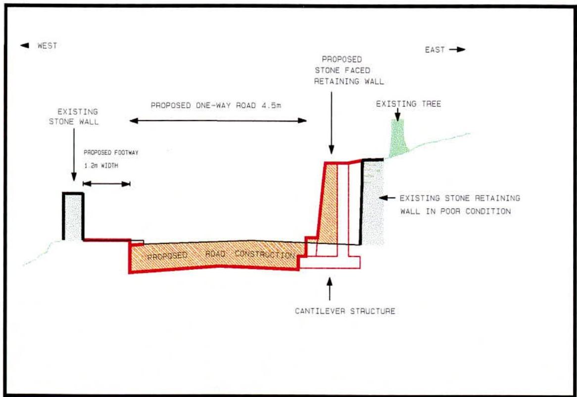
The cross-section A-A below shows a section of the existing road including the proposed strengthening of the retaining wall (the position of the section is shown on the following page).
As can be seen from the section the available road width, after the proposed strengthening is 4.5m. This is inadequate, even in a one-way system, for use by all traffic.
The minimum width required for a one-way road, to allow for an emergency vehicle to pass a heavy goods vehicle that has broken down is 6.0 metres.
As this option fails to meet this particular requirement further consideration is not warranted.
OPTION 3 ONE-WAY (NO HSV'S) SCALE 1:1250
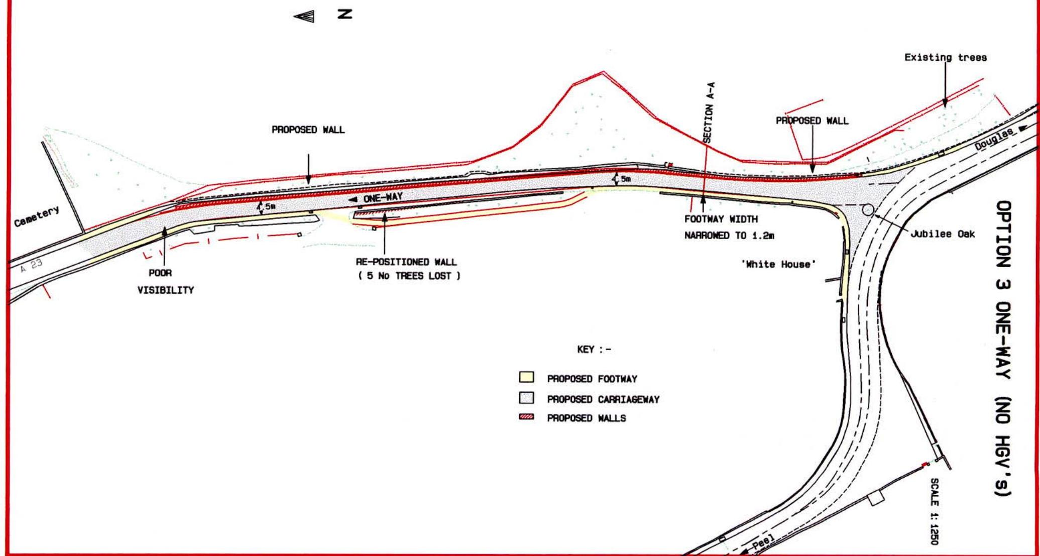
4.6 OPTION 3 - ONE-WAY AND RESTRICT HGV'S (see opposite) This option requires one-way traffic in a northerly direction away from Braddan Bridge. As in the previous option the retaining wall would be strengthened, and where possible, the footway moved away from the carriageway.
A one-way option from the southerly direction is discarded because it is unlikely to be acceptable to the emergency services for access to Ballamona.
Implications of one-way traffic flow
For a one-way traffic system to work satisfactorily there must be a complementary route to take the displaced traffic flow. This route must have sufficient capacity for the additional traffic.
Generally this route should also be one-way, parallel and close to the existing route. On occasions it may be necessary to provide more than one complementary route.
The most obvious complementary route is Tromode Road followed by Strang Road. Both are below standard and not really close to Braddan School Road.
Tromode Road would need to be widened over at least half of its length with a footway required at the Tromode end.
Strang Road, requires a full reconstruction as the surface is uneven and showing signs of failure over most of its length.
Further disadvantages of these routes are the extra distances that motorists will have to travel, and additional traffic use, particularly at the junctions. JMP traffic consultants have estimated that approximately 340 peak pm hour trips will be displaced from Braddan School Road with about 120 trips being diverted to Quarterbridge.
This will increase the flow on this road by 17% and increase the flow along Tromode Road by 100 trips. A further 160 trips are likely to divert to Strang Road increasing the level of traffic on these two routes by 60%.
The remaining 60 trips will use other routes such as along the promenade and over the new Harbour Bridge so as to avoid St. Ninians and Quarterbridge junctions.
In relation to the total vehicle travel time through the network JMP have estimated that this will be increased by approximately 10%. These factors would combine to indicate a marked economic disbenefit.
Thus the implementation of a one-way section on Braddan School Road will adversely affect flow of traffic on the adjacent roads already operating near capacity, increase travel time for many motorists, divert large commercial vehicles through residential areas and in economic terms have a negative rate of return, an overall disbenefit to road users.
Whilst there would be potentially a reduction in vehicle / pedestrian conflict, particularly in the area adjacent to the school, the speed of traffic is likely to increase (this nearly always occurs in one-way traffic streets).
The introduction of a 20 mph speed limit at opening and closing times outside the school could reduce this problem. However, increases in traffic on the other two complementary routes, would increase the potential for accidents and undesirable conflicts.
Copyright in submitted documents remains with their authors. Request removal
View as Markdown