Loading document...
Department of Planning
DEFA
Murray House
Mount Havelock
Douglas
Isle of Man
IM1 2SF
4th December 2019.
1901396
Dear Sir / Madam,
Re: Detailed planning application for proposed development of the former Ballagarey Nursey and Field adjacent to Greeba Avenue, including part of the garden to 7 Greeba Avenue 'Sunhill', consisting of 7 dwellings, including associated on-site infrastructure and landscaping works, and offsite highway upgrade works, Glen Vine, Isle of Man.
Please find enclosed a planning application for the above.
The following information is provided in support of this planning application and should be read with the application package, including the following documents:
The site is suitable for residential development and the proposals will make the best use of the site. The proposed site can be linked with the previously approved Ballabeg site and will provide an
alternative access for residents of Ballabeg during TT, as well as providing a more direct pedestrian and cycle access for existing residents of Greeba Avenue onto the A1 Peel Road.
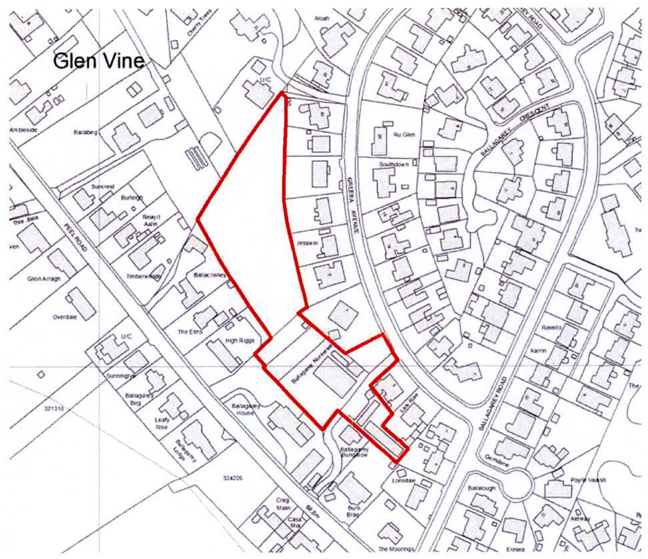
The proposed site is the former Ballagarey Nursery site and adjacent field, located in Glen Vine. The site is bounded by existing residential development on all sides and has a common boundary with the Ballabeg site in the north west corner.
The proposed site has been assessed for the potential for development through the Area Plan for the East process, site MH023. A 'Site Assessment Report' was produced by Isle of Man Government for this site, dated November 2016, which provides the following;
Planning history on No. 7 Greeba Avenue (Sunhill) Application 88/04356/B Extension to provide kitchen, bedroom and bathroom, Sunhill, Greeba Avenue, Ballagarey, Glen Vine, Marown Sunhill, Greeba Avenue, Ballagarey, Glen Vine, Marown MAROWN 28 Feb 1989
Application 90/04052/B Alterations to garage, Sunhill, Greeba Avenue, Ballagarey, Marown. Sunhill, Greeba Avenue, Ballagarey, Marown.
The following shows the full extent of Site MH023;
The proposed site excludes the small area of land directly behind No. 3 & No.5 Greeba Avenue. This small parcel of land will remain in the ownership of Ballagarey House & Bungalow, who have a common boundary with the land.
The Draft Area Plan for the East proposed MH023 to be designated as a Strategic Reserve site, with the following Recommendation (Site assessment Report, Final Summary):
> 'Evidence Paper DP EP 5 Household Size and Population Projections Paper (Update to review housing need, June 2019) identifies a lower housing need than originally planned for in the Draft Area Plan. Evidence Paper PIP 2 - Impact on the highway network of the Draft Area Plan for the East identifies that the Draft Plan will have a material impact on highway network performance and bus journey reliability. Such an impact may be reduced by
mitigation measures but there needs to be further assessment and monitoring to identify when this is at a level which may support the release of the Strategic Reserve sites (outside of the ATIP area) on traffic grounds. Given the strain on the main arterial routes when delivering the housing need, priority has been given to sites where active travel can realistically be delivered.
As the site is not within the Active Travel Investment Plan's 2.5 Mile radius of Central Douglas in the active travel investment plan area, it is recommended that the site be held as a Strategic Reserve until the need is evident and the impact on the supporting infrastructure is within acceptable limits. This site shall only be released in line with a defined methodology for this category of Strategic Reserve (i.e. a Strategic Reserve outside the ATIP area).'
However, during the Public Inquiry session into the Area Plan, held on the 20th September 2019, when sites in Glen Vine were discussed, the inspector questioned why this site was only identified as a reserve site, given its relatively small size and obvious suitability for residential development. The inspector went on to suggest whether the site could be 'washed over' in the final plan, which would formalise its zoning as a residential site. The Cabinet Office were in agreement with this suggestion.
For completeness, iTransport have dealt with the highway implications of this proposed development within their TA report.
The Area Plan for the East is currently awaiting the independent inspector's report to be submitted, with an anticipated adoption of the final Area Plan, by Tynwald, sometime in 2020. The Area Plan for the East will cover Glen Vine, but until its eventual adoption, the current designation of the site is covered by The Isle of Man Planning Scheme (Development Plan) Order 1982.
The site is currently identified as 'Area of Predominantly Residential Use' on the IOM Development Plan, and part of the site is within existing residential (the garden to Sunhill).
The site is also located within an existing residential area and within a settlement as identified in the Isle of Man Strategic Plan 2016.
The proposed development of residential dwellings on this site is therefore considered to be compatible with the adjacent land uses. The development would be compliant with present zoning and it is envisaged that although this application would likely be determined before the outcome of
the Area Plan is known, the land use designation (residential) is not likely to changed and therefore there would be no material impact or detriment to the Area Plan for the East.
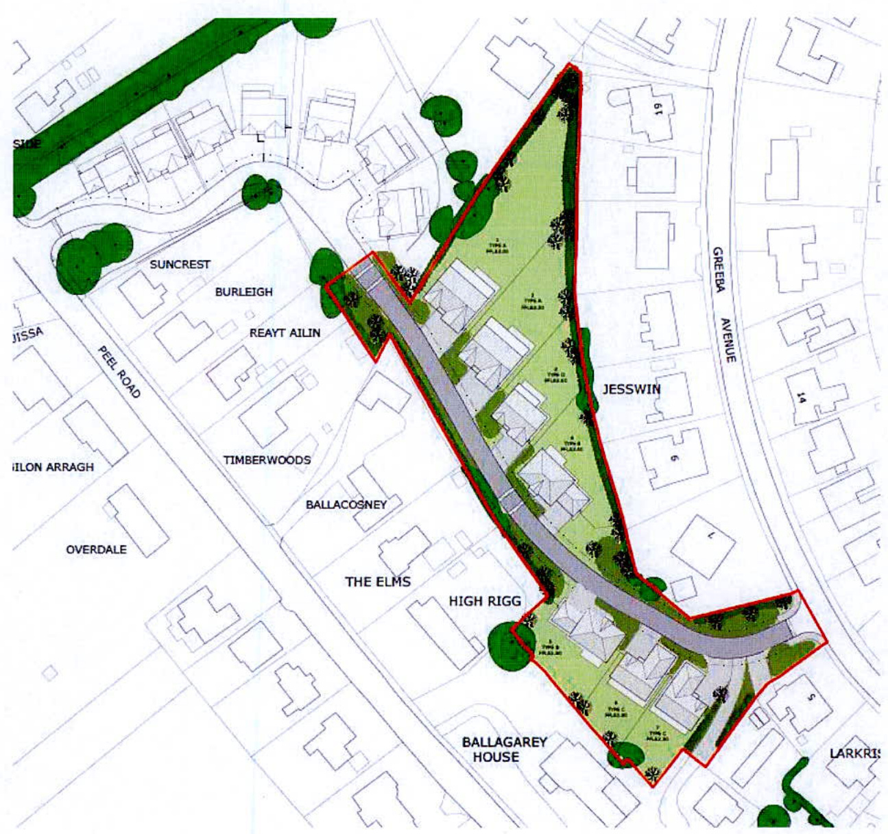
The proposed development will involve the construction of 7 dwellings and associated infrastructure and landscaping. A new access will be formed using the existing nursery access off Greeba Avenue, but widened by using part of the garden of No7, Sunhill, to accord with Manx Manual for Roads.
On entering the site, the access road will run west and then turn north west to run parallel to the south western boundary. 3no. properties will be served south west of the access road and 4 properties to the north east of the road.
Access will be maintained for No. 5 Greeba Avenue and provision for a new access will be made available to serve existing properties adjacent to the south east boundary.
The proposed site overlaps the Ballabeg site along their common boundary, towards the north west of the proposed site. This overlap allows the proposed access road to connect with the site road already approved for the Ballabeg site. This joining of the two access roads will provide vehicular access to the Ballabeg properties when the A1 Peel Road is closed, for example during TT. The connected site access roads will also provide a more direct pedestrian and cycle route from the existing houses in the Greeba Avenue area, down to the Peel Road, with access from there to local services and public transport.
All 7 proposed dwellings will be detached and two storeys in height. The houses will have pitched roofs and wall finishes utilising painted render and natural stone, similar to those previously approved for Ballabeg. The use of 4 different house types for the 7 dwellings, and the use of different external wall finishes, will add interest to the street view.
The proposed development density is similar to the surrounding area.
All properties will be provided with 2no. off road car parking spaces and good-sized gardens. Structure planting will be provided as part of the development, to provide visual amenity and all areas of landscaping will be assigned to specific properties, to ensure external spaces are maintained.
The proposed dwellings have been positioned to maintain the privacy of existing properties. A minimum face to face separation distance of at least 20m will be provided between existing and proposed properties, but generally separation distances are significantly greater.
Page 8 of 13
The narrow linear shape of the site and the need to provide a safe access from Greeba Avenue, will necessitate the removal of a number of trees (all Category C or below), to facilitate the proposed development.
An Aboricultural Impact Assessment has been produced by Manx Roots and is submitted as part of this planning application. The AIA, identifies trees and groups of trees which will be retained and which ones will be removed to allow the proposed development to proceed.
Manx Roots have also provided advice on the protection of existing trees during the construction stage of the project. Full tree protection will take place as per normal and a tree protection plan forms part of this application.
The proposed development includes the planting of a large number of new trees and shrubs, to soften the streetscape, as detailed on the proposed landscape plan, including a highly landscaped access from Greeba Avenue. Existing site boundary planting will be retained where possible, tidied up and reinforced with additional planting, to provide mutual privacy between proposed and existing properties.
Approximately 40 new trees are being proposed to be planted as part of the development, and together with the extensive additional hedgerow and ornamental shrub planting, will more than offset the trees being lost. Also, the native plant species being proposed will establish well, and obtain a mature appearance in a short time period.
Manx Roots have confirmed that the proposed landscaping proposals will 'mitigate the trees being lost'. Additionally, future property owners are likely to plant additional tree and shrubs within their own gardens, which will add to the ecological variety of the site.
Roads and driveways will be formed in contrasting colour block paviors and the modular scale of the paviors will help provide a residential setting for the development.
iTransport have assessed the proposed scheme and their report is included as part of the planning application package. They conclude that the proposals are fully compliant with all design requirements set out in MFMR etc
The site access will be from Greeba Avenue and will correspond to the access previously serving Ballagarey Nursey, but widened by utilising some land from the property known as Sunhill (also owned by the current landowner), to achieve the required junction visibility splay. The proposed access has been designed in accordance with Manx Manual for Roads and all relevant design guides. It is proposed that the site road will be adopted by the Highways Department.
As previously mentioned, the development of this site will also provide the opportunity to give an alternative access to the 7 properties in 'Ballabeg', which will be beneficial during TT fortnight and during the Festival of Motorcycling when the A1 is closed.
Whilst the proposed development will provide a direct vehicular link between Greeba Avenue and the A1, we do not believe this will become a short cut for vehicles, for a number of reasons;
The above measures are intended to reduce vehicles speeds traveling through the proposed development and as a result, this will eliminate any time advantage, meaning that they are less likely to use this route as a shortcut.
Both storm and foul water drainage connections are possible through the northern end of the site, through the Ballabeg development and connecting into sewers recently installed, which connect in to those located on the A1 road. Indicative drainage routes are included within the application package.
The proposed site is surrounded by existing residential development and all utility services are available to serve the proposed site.
The Isle of Man Strategic Plan, Housing Policy 5, states; 'In granting planning permission on land zoned for residential development or in predominantly residential areas the Department will normally require that of provision should be made up of affordable housing. This policy will apply to developments of 8 dwellings or more.'
The development proposes 7 dwellings, which achieves a similar density to the existing properties in the area. Therefore, there is no requirement to provide affordable homes as part of these proposals.
The requirement for the provision of open space is set out in Appendix 6 of the Isle of Man Strategic Plan 2016. Para A.6.1.2 of appendix 6, states; 'It is not considered feasible to request smaller residential developments to make provision for open space either through on-site provision or by way of a commuted sum payment. Therefore, planning applications for the development of ten dwellings and above will have to make provision for open space.'
The proposed development is for 7 properties, therefore there is no requirement for Public Open Space to be provided.
Whilst POS is not proposed to be provided, the development does include areas of amenity landscaping at the site entrance and along the access road. These areas will be assigned to specific properties to ensure they are suitably maintained.
All 7 proposed properties will include large front and rear gardens, offering ample play and amenity space.
The Site is within 1km of 2 areas of Public Open Space (Marown Memorial Playing Fields and Marown Primary School Playing Fields),
The following points are relevant to this application;
The site is suitable for residential development and the proposed use is compliant with the present designation which is 'predominantly residential'. The proposals will make the best use of the site at a similar density to the adjacent development. The linking of the site with the previously approved 'Ballabeg' site will provide an alternative access for residents of Ballabeg, as well has providing a pedestrian or cycle route for existing residents of Greeba Avenue, onto the A1 Peel Road.
Overall, the proposed development will add much needed family homes for the East of the Island with the ability for these homes to be built relatively quickly, on land which is currently zoned, and also proposed to be zoned for residential development by the Area Plan for the East.
We trust the above and enclosed information provides sufficient information for this application to be considered but should you have any questions then please do not hesitate to contact our offices.
Yours faithfully
George Li
For and on behalf of Hartford Ltd.
Copyright in submitted documents remains with their authors. Request removal
View as Markdown