**Document:** APL Planning Statement
**Application:** 22/00520/B — Proposed erection of dwelling
**Decision:** Permitted
**Decision Date:** 2022-10-03
**Parish:** Lezayre
**Document Type:** report / planning_statement
**Source:** https://planningportal.im/a/8906-lezayre-land-to-the-new-build-dwelling/documents/950671
---
# APL Planning Statement
## Planning Statement To Support The Erection Of A Dwelling, Plot Adjacent To 17, Royal Park, Ramsey
|Executive summary
This site is highly sustainable, within a major settlement and within safe and convenient walking distance of amenities, facilities and infrastructure. Its development is supported by the Strategic Aim, Strategic Policies 2 and 10, Spatial Policies 2 and 5, Housing Policy 4 and Transport Policy 10.
The proposed development will have sufficient car parking and adequate potential for the secure storage of bicycles in accordance with Transport Policy 7 and the Residential Design Guidance and will not have any adverse impact on the living conditions of those in adjacent property, in accordance with General Policy 2 and the Residential Design
The previous decisions to refuse development on this site have been taken into account and the appearance of the proposed dwelling incorporates the important elements which characterise this streetscene whilst providing more interest in the different roof shape. This streetscene and the estate generally is already varied and what is proposed will add more interest without appearing out of place and will be built to modern Building Regulation standards of thermal and energy efficiency, in accordance with General Policy 2, Strategic Policies 3 and 5, Environment Policy 42, Housing Policy 6 and the Residential Design Guidance.
The development will incorporate new planting and bird and bee habitat so will not result in any biodiversity net loss, potentially a net gain as well as management of this piece of land for the benefit of those who pass or live around it.
There will be no adverse impact on the living conditions of those in adjacent residential properties and thus the proposal complies with General Policy 2 of the Strategic Plan and the Residential Design Guidance.|
|---|
- 1.0 Introduction
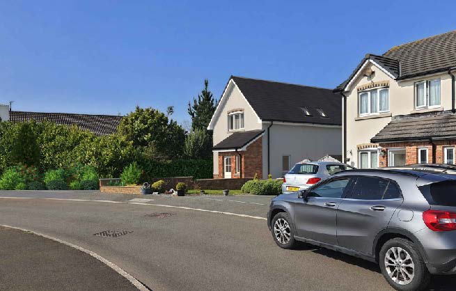
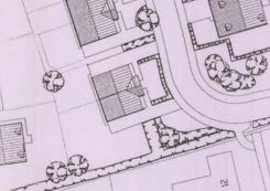
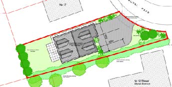
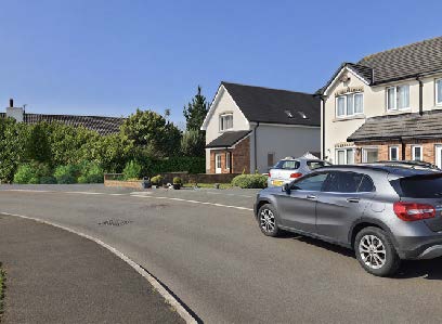
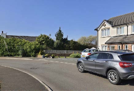
- 1.1 The site is a piece of land which sits to the west of 17, Royal Park, the western half of a pair of semi detached, two storey houses. This pair is one of a number on the northern side of this short avenue, the others being another pair of semi detached houses (number 7 and 9) and a terrace of three (11, 13 and 14). Number 14 has been extended to the west (see Planning History) and number 16 has permission for a similar extension although this has not yet been implemented. The proposed site is not part of the garden of number 17 and extends further south than does this adjacent curtilage.
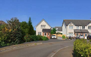
- 1.2 On the other side of the road are two storey houses and a dormer bungalow, the houses having single storey lean-to side annexes.

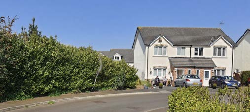
- 1.3 Elsewhere in this relatively new estate, there is a mix of house types within each street but with a consistency of materials: front elevations include projecting gables as ca be seen above as well as flatter frontages.
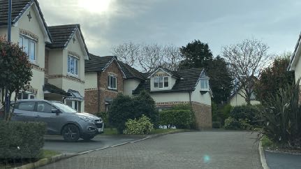
- 1.4 The estate is overlooked by the older properties in Rheast Mooar Avenue and Cooil Breryk which generally sit higher than the newer estate of which this plot forms part although the estate is separated from these adjacent areas by established and substantial hedging.

- 2.0 Planning context
- 2.1 The site lies within an area designated on the Ramsey Local Plan of 1998 as Proposed Residential. The estate was constructed under a series of applications in the 2000s.
- 2.2 Development of this site is therefore consistent with the land use designation and General Policy 2 of the Strategic Plan (see Appendix One) is the appropriate general policy which requires that development is visually and environmentally acceptable and does not result in any adverse highway safety issue. Development is now required to demonstrate that it addresses climate change and that new dwellings are thermally and energy efficient and that where possible, should result in biodiversity net gain and generally not result in biodiversity net loss (Residential Design Guidance).
- 2.3 The Strategic Plan encourages sustainably located development (Strategic Policies 1, 2 and 10, Spatial Policy 5, Housing Policy 4 and Transport Policy 1.
- 2.4 Good and appropriate design is encouraged in Strategic Policies 3 and 5, Environment Policy 52 and Housing Policy 6 and the Residential Design Guidance.
- 2.5 The site is not within a Conservation Area, there are no Registered Trees or Registered Buildings on the site and it is not shown as being at risk of flooding on the national flood risk maps.
- 3.0 Planning history
- 3.1 The estate was approved under 04/02310/B, 04/02311/B and 07/00364/B.
excerpt from 04/02310/B
excerpt from 07/00364/B
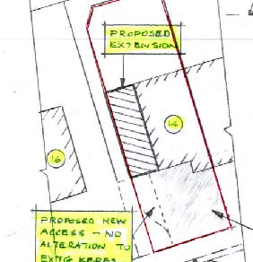
- 3.2 Subsequent to the approval of this row of houses, some have been approved for alterations and extensions including the sideways extensions of number 14 and 16:
20/01143/B - extension of 16, Royal Park - permitted
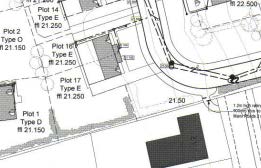
## 18/00953/B 14, Royal Park
- 3.3 The application land has also been the subject of three previous applications for the construction of a dwelling. All were refused although the most recent application was recommended for approval by the planning officer and approved by the Planning Committee.
- 3.4 08/02191/B proposed a detached dwelling with attached lean-to garage to the west.
- 3.5 This application was refused for the reason that:
“1. The proposed dwelling, by virtue of its size and height, and its proximity to the neighbouring property 12 Rheast Mooar Avenue, would adversely affect the residential amenity of neighbouring property, particularly in respect of having an overbearing impact and would therefore be un-neighbourly and dominant in respect of the outlook and enjoyment of the occupiers. As such the proposed development is contrary to criterion (g) of General Policy 2 of the Isle of Man Strategic Pian 2007.
- 2. The proposal would result in the loss of an area of public open space as indicated and approved under the previous planning application 04/02310/6. Approval of the application to allow the encroachment of residential development into land that is designated as public open space would detract from the character and amenities of the development and would result in an unwanted precedent in this area and in other areas of public open space within the Island.”
- 3.6 18/01106/B was refused initially and confirmed on appeal, for the reasons that:
“The proposal, by reason of its siting, layout, scale, form , design and the spaces around the building adversely affect the character of site and surroundings and the local townscape in general contrary to General Policy 2(b) and 2(c) and Environment Policy 42 of the Isle of Man Strategic Plan 2016.”
- 3.7 The Inspector considering the appeal considered that the main issues of the appeal were:
- i. the character and appearance of the site and surrounding part of the Royal Park estate, with respect to the loss of open space within the site and with regard to the wider street scene,
- ii. the amenity of the three adjoining properties with respect to dominance, overshadowing, outlook and privacy, and
- iii. any effect on highway safety.
- 3.8 He did not consider the principle of the erection of a dwelling on this site to be unacceptable as the retention of the landscaped space at the front of the site would perpetuate the open character of the front of the site so there would be no conflict with Environment Policy 42. He was concerned, however, with the narrow width of space between the side of the proposed house and the boundary with number 17 and the diminutive scale of the house compared with its neighbours whilst, at the same time, being cramped on the plot given its width. No objection was found to the proposal in terms of its impact on the living conditions of those in adjacent dwellings.
- 3.9 20/01063/B saw a further attempt at planning approval for a dwelling on this plot, this time the application being approved initially but an appeal was sought by Ramsey Town Commissioners and was allowed. The application was refused for the reason that:
## “The proposed development would, if approved, be out of keeping and harmful to the appearance and character of the the streetscene in this part of Royal Park, contrary to
## General Policy 2(b) and 2(c) and Environment Policy 42 of the Isle of Man Strategic Plan 2016.”

- 3.10 This inspector agreed that there was no issue with the principle of a dwelling on this site, the impact on highway safety, neighbours’ amenity or the appearance of the house in itself. He was, however, concerned that the proposed house would have a harmful effect on the street scene, notes the still narrow gap between the property and number 17 and seen in the context of number 17 and its neighbours the proposed dwelling, which is not semi-detached or terraced and has insufficient gaps between it and the house next door compared with others in the same streetscene. It still appeared to be cramped and not spacious as are its neighbours. In his view the detached nature of the property exacerbated the narrowness of the plot and was unacceptable.
## 4.0 The proposal
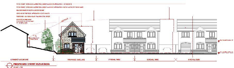
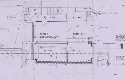
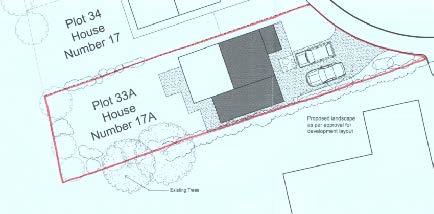
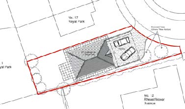
- 4.1 Proposed is the introduction of a dwelling on the space to the west of 17, Royal Park and between is and the eastern boundary of 12, Rheast Mooar Avenue.
- 4.2 The dwelling is a detached dwelling which has its ridge running perpendicular to the estate road. It has car parking in front of the building but retaining a roughly triangular area of landscaping between the dwelling and the estate road, to the south of the parking area.
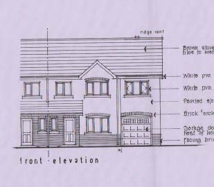
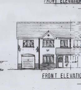
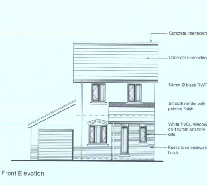
- 4.3 The dwelling continues the finish materials and window and door detailing of the other houses in this line within the estate - the same roof pitch, the same porch feature and arches brick heads above the windows and door and the dwelling sits on the same building line as do 16 and 17, Royal Park immediately to the east.
- 4.4 The dwelling will be offset from the eastern elevation of 12, Rheast Mooar Avenue such that the windows in it will not look directly towards the new house but will continue to look over the open space which will remain in front of the new house.
- 4.5 The dwelling will be in excess of 20m from the rear of 1, Royal Park to the north with a similar relationship with this existing property as it already has with 17, Royal Park.
- 4.6 Visibility splays of 2.4m by 43m in each direction are available at the entrance to the plot for those in vehicles leaving the site.
- 4.7 Bird and bee habitat will be incorporated into the new building.
- 4.8 There will be a ground floor window and two roof lights in the eastern elevation facing 17, Royal Park which has no windows at these levels. This ground floor window serves a hall at the bottom of the stairs.
## 5.0 Assessment
- 5.1 There is no issue with the principle of a dwelling on this plot. The proposal will provide the two parking spaces required by the Strategic Plan and there will be secure parking for bicycles The issues, raised in the previous applications, are how a new dwelling will sit comfortably into the street scene.
- 5.2 The Strategic Plan and Residential Design Guidance makes it clear that development must sit comfortably into a landscape but advises both that consideration should be given the the context of the site and the materials and form around it whilst also not stifling innovation and interest. Paragraph 4.3.8 sums it up perfectly when it says that recent development has often been criticised for its similarity to developments across the Island and elsewhere – ‘anywhere’ architecture whilst at the same time, some criticise current practice to retain traditional or vernacular designs and the truth lies somewhere in between.
- 5.3 The context of this site is that it sits at the end of a row of similar, two storey properties but which have different characteristics within the row - some are semi-detached, some are terraced and some have been extended, reducing the space between the properties. It is also relevant that opposite this site is a row of similar properties which are semi-detached but at the end of it, directly opposite the application site, is a lower, different property which does not have the same amount of facing brickwork, has dormer windows and a completely different appearance from the rest of the row.
- 5.4 Around the corner is a row of properties which comprises two storey, brick faced houses at each end and dormer bungalows with rendered facades in between. Further south there is more variety with some houses having garages with dormer accommodation above, at right angles to the main house. All of this variety adds interest to the estate and assists the transition between the new estate and the older properties which overlook and can be seen from and as part of some of the streets within the new estate and, in fact the great variation provides scope for alternative designs to fit in without appearing out of place.
- 5.5 What is proposed here is different in terms of the orientation of the ridge, but retains the same pitch of roof as its neighbours and the appearance and style of windows, the use of facing brick details and porch feature and the gable end frontage is similar to many gable details of the existing properties in this estate. It is considered that this mix provides the interest and variety encouraged by the Strategic Plan and Residential Design Guidance but at the same time, respecting the materials and general appearance of the rest of the street scene. We consider this to be an acceptable approach and something that will visually complete the street scene.
- 5.6 The proposal will provide sufficient space for a shed to be constructed under Permitted Development in which a bicycle or bicycles may be stored securely if required and parking for at least two vehicles whilst retaining the open, landscaped area at the front of the plot. This area will be enhanced by additional planting of local species which are valuable to nature and the development includes bird and bee habitat (see Design and Access Statement).
- 5.7 The proposed dwelling contains only one window in the side elevation facing number 17 and this is at ground floor level and faces a blank wall and whilst there is a first floor window in the rear elevation, this will be in excess of 20m from any windows in the property to the rear, 1, Royal Park, and this relationship is little different to that of the rest of the row and the properties to their north. The roof lights serve a staircase and bathroom so will not result in permanent use where overlooking would be an issue. The proposed dwelling will not project any further forward than does number 17 and not significantly further back so there should be no impact on the outlook from the windows in number 17. The proposed dwelling is set back from the eastern elevation of 12, Rheast Mooar Avenue so there should be no impact on that dwelling and the vegetation between the plot and it will be retained.
## 6.0 Conclusion
- 6.1 It is considered that the proposal will make better use of an unused piece of land within an almost complete estate, in accordance with Strategic Policy 1, in a sustainable location within a main settlement, in accordance with Strategic Policies 2 and 10, Spatial Policies 2 and 5, Housing Policy 4 and Transport Policy 10.
- 6.2 The proposed development will have sufficient car parking and adequate potential for the secure storage of bicycles in accordance with Transport Policy 7 and the Residential Design Guidance and will not have any adverse impact on the living conditions of those in adjacent property, in accordance with General Policy 2 and the Residential Design Guidance.
- 6.3 It is considered that the appearance of the proposed dwelling incorporates the important elements which characterise this streetscene whilst providing more interest in the different roof shape. It is important to note that this streetscene and the estate generally is already varied and what is proposed will add more interest without appearing out of place in accordance with General Policy 2, Strategic Policies 3 and 5, Environment Policy 42, Housing Policy 6 and the Residential Design Guidance.
- 6.4 The development will incorporate new planting and bird and bee habitat so will not result in any biodiversity net loss, potentially a net gain as well as management of this piece of land for the benefit of those who pass or live around it.
Sarah Corlett 05.04.2022
Appendix One - Planning policy
Strategic Plan 2016 General Policy 2
Strategic Aim: To plan for the efficient and effective provision of services and infrastructure and to direct and control development and the use of land to meet the community’s needs, having particular regard to the principles of sustainability whilst at the same time preserving, protecting, and improving the quality of the environment, having particular regard to our uniquely Manx natural, wildlife, cultural and built heritage.
- Strategic Policy 1: Development should make the best use of resources by:
- (a) optimising the use of previously developed land, redundant buildings, unused and under-used land and buildings, and reusing scarce indigenous building materials;
- (b) ensuring efficient use of sites, taking into account the needs for access, landscaping, open space(1) and amenity standards; and
- (c) being located so as to utilise existing and planned infrastructure, facilities and services.
- Strategic Policy 2: New development will be located primarily within our existing towns and villages, or, where appropriate, in sustainable urban extensions(2) of these towns and villages. Development will be permitted in the countryside only in the exceptional circumstances identified in paragraph 6.3.
- Strategic Policy 3: Proposals for development must ensure that the individual character of our towns and villages is protected or enhanced by:
- (a) avoiding coalescence and maintaining adequate physical separation between settlements; and
- (b) having regard in the design of new development to the use of local materials and character.
Strategic Policy 5: New development, including individual buildings, should be designed so as to make a positive contribution to the environment of the Island. In appropriate cases the Department will require planning applications to be supported by a Design Statement which will be required to take account of the Strategic Aim and Policies.
Strategic Policy 10: New development should be located and designed such as to promote a more integrated transport network with the aim to:
- (a) minimise journeys, especially by private car;
- (b) make best use of public transport;
- (c) not adversely affect highway safety for all users, and
- (d) encourage pedestrian movement
Spatial Policy 2: Outside Douglas development will be concentrated on the following Service Centres to provide regeneration and choice of location for housing, employment and services…Ramsey Area Plans will define the development boundaries of such centres so as to provide a range of housing and employment opportunities at a scale appropriate to the settlement.
Spatial Policy 5: New development will be located within the defined settlements. Development will only be permitted in the countryside in accordance with General Policy 3.
General Policy 2: Development which is in accordance with the land-use zoning and proposals in the appropriate Area Plan and with other policies of this Strategic Plan will normally be permitted, provided that the development:
- (a) is in accordance with the design brief in the Area Plan where there is such a brief;
- (b) respects the site and surroundings in terms of the siting, layout, scale, form, design and landscaping of buildings and the spaces around them;
- (c) does not affect adversely the character of the surrounding landscape or townscape;
- (d) does not adversely affect the protected wildlife or locally important habitats on the site or adjacent land, including water courses;
- (e) does not affect adversely public views of the sea;
- (f) incorporates where possible existing topography and landscape features, particularly trees and sod banks;
- (g) does not affect adversely the amenity of local residents or the character of the locality;
- (h) provides satisfactory amenity standards in itself, including where appropriate safe and convenient access for all highway users, together with adequate parking, servicing and manoeuvring space;
- (i) does not have an unacceptable effect on road safety or traffic flows on the local highways;
- (j) can be provided with all necessary services;
- (k) does not prejudice the use or development of adjoining land in accordance with the appropriate Area Plan;
- (l) is not on contaminated land or subject to unreasonable risk of erosion or flooding;
- (m) takes account of community and personal safety and security in the design of buildings and the spaces around them; and
- (n) is designed having due regard to best practice in reducing energy consumption.
Paragraph 4.3.8: “The design of new development can make a positive contribution to the character and appearance of the Island. Recent development has often been criticised for its similarity to developments across the Island and elsewhere – ‘anywhere’ architecture. At the same time, some criticise current practice to retain traditional or vernacular designs. As is often the case the truth lies somewhere between the two extremes. All too often proposals for new developments have not taken into account a proper analysis of their context in terms of siting, layout, scale, materials and other factors. At the same time a slavish following of past design idioms, evolved for earlier lifestyles can produce buildings which do not reflect twenty first century lifestyles including accessibility and energy conservation. While there is often a consensus about what constitutes good and poor design, it is notoriously difficult to define or prescribe”.
Environment Policy 42: New development in existing settlements must be designed to take account of the particular character and identity, in terms of buildings and landscape features of the immediate locality. Inappropriate backland development, and the removal of open or green spaces which contribute to the visual amenity and sense of place of a particular area will not be permitted. Those open or green spaces which are to be preserved will be identified in Area Plans.
Housing Policy 4: New housing will be located primarily within our existing towns and villages, or, where appropriate, in sustainable urban extensions(1) of these towns and villages where identified in adopted Area Plans: otherwise new housing will be permitted in the countryside only in the following exceptional circumstances:
- (a) essential housing for agricultural workers in accordance with Housing Policies 7, 8, 9 and 10;
- (b) conversion of redundant rural buildings in accordance with Housing Policy 11; and
- (c) the replacement of existing rural dwellings and abandoned dwellings in accordance with Housing Policies 12, 13 and 14.
Housing Policy 6: Development of land which is zoned for residential development must be undertaken in accordance with the brief in the relevant area plan, or, in the absence of a brief, in
accordance with the criteria in paragraph 6.2 of this Plan. Briefs will encourage good and innovative design, and will not be needlessly prescriptive.
Transport Policy 1: New development should, where possible, be located close to existing public transport facilities and routes, including pedestrian, cycle and rail routes.
Transport Policy 4: The new and existing highways which serve any new development must be designed so as to be capable of accommodating the vehicle and pedestrian journeys generated by that development in a safe and appropriate manner, and in accordance with the environmental objectives of this plan.
Transport Policy 7: The Department will require that in all new development, parking provision must be in accordance with the Department’s current standards.
Appendix 7 suggests that new housing should be provided with two parking spaces ideally within the curtilage and with one behind the front of the dwelling.
## Residential Design Guidance July 2021
- 1.1.1 The aim of this guidance is to help all of those involved in the design process (developers, homeowners, architects and agents and planners) to work together to improve the quality of our built environment. It is hoped that this document will encourage creative, innovative and locally distinctive designs that respond to the changing needs of our communities.
- 1.1.2 This document is not intended to stifle creativity or to promote planning by numbers and off the peg designs, but rather to create a supportive context for good quality designs, be they traditional or modern.
- 1.2.3 All planning applications will be judged on their own merits, taking account of the likely effect on neighbouring properties and the character of the building or street.
- 1.3.2 Where an application is accompanied by a design statement, it provides an opportunity for the applicant to explain how they have considered a Sustainable Construction approach (see Chapter 2.0) responded to the need to: maximize carbon sequestration; minimize greenhouse gas emissions; maintain and enhance ecosystems; achieve biodiversity net gain; provide sustainable drainage systems; and provide active travel and public transport infrastructure.
- 3.1.2 This document is intended to facilitate good quality design, and an important aspect of that is local distinctiveness.
- 3.1.3 New residential development should be informed by the best qualities of our existing residential areas. However, this does not mean that all new residential developments should seek to replicate the appearance of older ones, and good quality contemporary design is encouraged.
- 3.1.4 Nevertheless, it is important that the design of new residential developments, including their scale (including height), form, layout/orientation, and detailed design (including the materials used) is informed by and respects both the nature of the development site and the character of the neighbouring buildings and surrounding area.
- 3.1.5 The character and context of any residential development is created by the locally distinctive patterns and form of development, landscape, culture, and biodiversity. These elements have often built up over a considerable time and tell a story of the site's history and evolution - the creation of a ‘sense of place’.
- 3.2.1 A residential development should avoid having the same type, height, and density throughout, including avoiding continuous, bland, and uninteresting roofscapes.
- 3.3.6 Car parking should be sensitively accommodated within, and not dominate, the streetscape. Where possible it should be behind the building line, or it may be appropriate to have parking off the main estate roads in parking closes.
3.3.7 Developments should also incorporate appropriate provision for the secure and convenient storage of bicycles to promote more sustainable methods of transport (See Paragraph 2.6.2).
3.6.2 Land is a finite resource and it is important to strike a balance between the need to make best use of land (i.e. by maximising densities, so that as many dwellings as possible can be provided on the least amount of land thus reducing the need to develop new areas) and the need to make sure that new developments are attractive and fit-for-purpose. Changing the use of land, particularly from green field to developed, can also significantly contribute to our greenhouse gas emissions.
- 7.3 Loss of Light/Overshadowing
- 7.3.1 A development should not result in significant levels of loss of day light or overshadowing, especially to primary habitable rooms, or to private gardens.
- 7.3.2 Applicants are advised to look carefully at the path of the sun throughout the day, and consider where shadows fall, using this information to help in considering the design, position and height of the extension.
- 7.3.3 The impact of overshadowing will increase if the new property/extension is to the south of a neighbouring property (as the sun’s orientation is east to west). When the windows affected serve habitable rooms then it will be necessary to assess the impact upon light reaching these rooms. (Continue to Paragraph 7.3.4) 7.0 Impact on Neighbouring Properties
- 7.4 Overbearing Impact upon Outlook The “25 Degree Check”
- 7.3.4 A simple check can be undertaken in relation to this issue (also see Figure 7.A below):
A side view is drawn which includes the proposal site and the main face of the neighbouring property. A point is identified which is 2 metres above ground level on the closest wall with a relevant window of the neighbouring building. A line is drawn from this point at a 25 degree angle towards the application site. If no part of the proposal is above this line, there will still be the potential for good daylight to the interior.
- 7.3.5 Where a change in level separates two adjoining dwellings, a proposal for a dwelling on a higher site or an extension to the higher dwelling, will normally have a far greater effect on its lower neighbours than in the reverse. 7.4 Overbearing Impact upon Outlook
- 7.4.1 Any development should ensure that existing residents can enjoy appropriate levels of comfort and enjoyment of their properties without their outlooks being impacted by an overbearing building/ structure.
- 7.4.2 The positioning, design and scale of an extension/new build dwellings should not be dominant or have an adverse impact on the primary windows of a primary habitable room or on the private garden that may be present in a neighbouring property.
- 7.4.3 It is normally possible to avoid overlooking with careful design and by following the guidance set out within this document.
- 7.4.4 The impact on a private garden may include consideration of the overall size of the garden and whether only a small part of it is likely to be impacted on detrimentally.
- 7.5 Overlooking Resulting in a Loss of Privacy
- 7.5.1 Overlooking can take a variety of forms, whether created by a window or the creation of roof terrace/balcony.
- 7.5.2 The intensity of overlooking depends on a variety of a factors, such as the use of the overlooking spot, the use of the area being overlooked, the typical duration of usage, and any mitigation methods can be used to reduce the overlooking, such as opaque glazing. The “20 Metre Guide”
- 7.5.3 The “20 metre guide” provides a useful way to identify where overlooking is likely to be a concern. It refers to the distance between elevations that contain windows serving habitable rooms that face each other.
- 7.5.4 If this distance is over 20 metres, overlook is unlikely to be a concern.
- 7.5.5 This distance can be relaxed, where the design or orientation is such that privacy and amenity of a neighbouring property is not compromised.
- 7.5.6 In dense urban areas, where there is already a level of mutual overlooking, a lesser standard may be acceptable.
- 7.5.7 The required distance may need to be greater, if there is a change in topography, which would result in an adverse effect on the privacy and amenity of a neighbouring property.
---
*Data sourced from the Isle of Man public planning register under the [Isle of Man Open Government Licence](https://www.gov.im/about-this-site/open-government-licence/).*
*Canonical page: https://planningportal.im/a/8906-lezayre-land-to-the-new-build-dwelling/documents/950671*