**Document:** S278 Designer’s Response to RSA1
**Application:** 20/01507/A — Approval in principle for four detached dwellings and associated access
**Decision:** Permitted
**Decision Date:** 2021-12-15
**Parish:** Santon
**Document Type:** report / planning_statement
**Source:** https://planningportal.im/a/7009-santon-conister-dwelling/documents/1577523
---
# S278 Designer’s Response to RSA1
REP-002
## S278 Designer’s Response
### to RSA1 Comments on Development Access Arrangement
#### September 2021
By Alexious Mavhunga Chartered Civil Engineer (CENG, MSc, BSc Hons)
##### Contents Amendment Record
This report has been issued and amended as follows:
|Issue|Revision|Description|Date|Signed|
|---|---|---|---|---|
| |P01|First Issue for Comment|2021-09-09| |
| | | | | |
| | | | | |
| | | | | |
| | | | | |
|REF|DESIGN ISSUE RAISED (by HMTC)
|DESIGNER’s RESPONSE (by A. Mavhunga)
|
|---|---|---|
|Problem 01
Location:
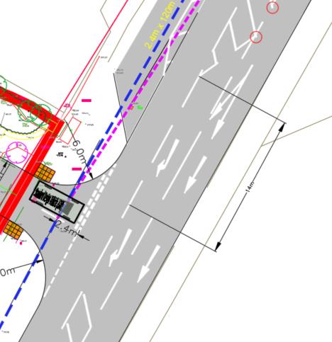
A5 Main Road at junction with new access road into proposed development|a) Visibility to the left (north of the access) onto the A5 Main Road may be restricted by parking which could result in junction emergence collisions.
b) The proposals have been amended to restrict parking in the vicinity of the new access however if there are parked vehicles to the left of the site in the parking layby, visibility may still be restricted, which could result in junction emergence collisions.
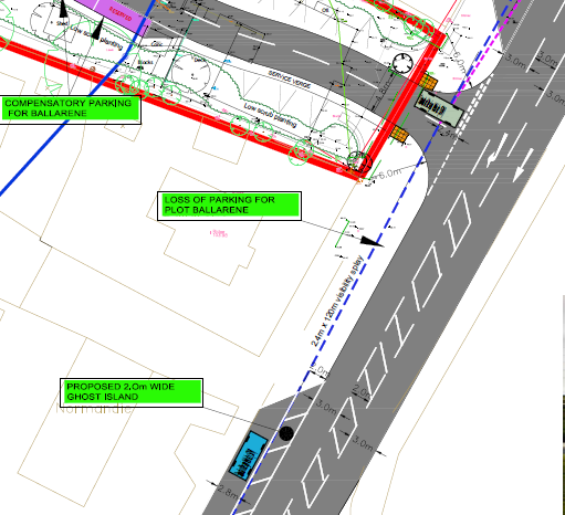
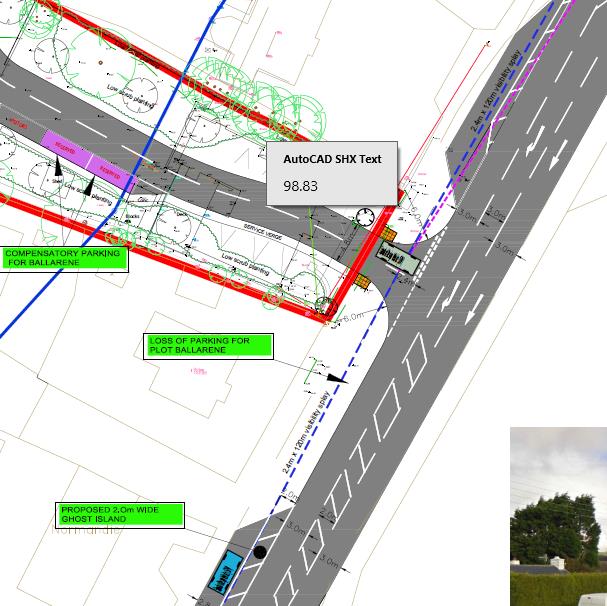
|a) The submitted layout shows existing parking curtailed further to the left away from the junction and a 2.0m ghost island provided to ensure that a stationery vehicle at the give way line provides a motorist with full 120m visibility.|
| |
|---|
|REF|DESIGN ISSUE RAISED (by HMTC)
|DESIGNER’s RESPONSE (by A. Mavhunga)|
|---|---|---|
|Problem 02
Location:
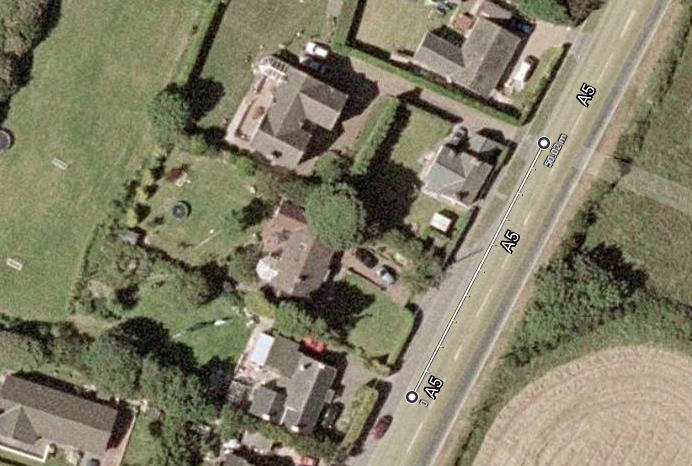
Existing Pedestrian Refuge on A5 Main Road near junction with new access road|a) Conflict with existing refuge island and right turn ghost island traffic into the Ballavartyn Equestrian Centre resulting in potential collisions.|a) There is over 50m between the proposed Development Access and the right turn ghost island into the Ballavartyn Equestrian Centre. The illustrative current layout shows a 35m Storage Length: only 10m (two PCUs) would be sufficient for proposed 4 houses. The apparent conflict is therefore actually non-existent if a detailed design is carried out based on a detailed Topographical Survey of the A5. If 10m Storage Lengths are provided on both accesses (to Ballavartyn Equestrian Centre and to The Development), a clear 30m of ghost island will be left in between.
b) The pedestrian refuge will be re-located in between the two accesses, 15m away from each right turn lane.
|
| |
|---|
| |
|---|
###### Google Map showing 50m distance between the two accesses
|REF|DESIGN ISSUE RAISED (by HMTC)
|DESIGNER’s RESPONSE (by A. Mavhunga)
|
|---|---|---|
|Problem 03
Location:
New access road at interface with existing highway and within site boundary|a) No drainage or gully detail has been shown at the junction of the new access road with the existing highway or buildouts and within the site boundary.
There are gullies on the A5 on either side of the proposed access but they may not be in the correct location to suit the new arrangement. Without any cross-section or longsection detail it is difficult to ascertain which way the carriageway falls and where any water will drain.
Failure to provide adequate drainage could result in vehicles losing control in standing water especially in icy and wet weather conditions.|a) The Priority Access layout is at Conceptual Stage, designed to in 2D to demonstrate that it is practically possible to design a Development Access that works at this location.
b) At detailed design, the crossfall of the existing A5 will not change, therefore drainage will be provided by gullies placed at low points on the A5 and along the Development Access.
c) Double gullies will be placed at trough / sag locations.
d) A cut-off linear drain (ACO RoadDrain) will be placed at the end of the Development Access near the Give Way Line at the highway boundary to stop private runoff from flowing onto the A5.
|
|REF|DESIGN ISSUE RAISED (by HMTC)
|DESIGNER’s RESPONSE (by A. Mavhunga)|
|---|---|---|
|Problem 04
Location:
New access road within site boundary|a) Risk of collisions due to inadequate turning / width for vehicle manoeuvres within the site.
b) Although swept path analysis has now been provided for audit, it indicates that vehicles will overrun certain areas including the service margin within the cul-desac turning head.
c) A refuse wagon turning right into the access road completely overruns the exit from the site and if a vehicle is waiting to turn out there may be conflict on the main road as vehicles are turning in. If a refuse or delivery wagon cannot manoeuvre safely there is a risk of a collision with other vehicles or pedestrians using the shared use area.
|a) Turning manoeuvres within the site should not be covered by the RSA1 because the Development Access Road will be private and not part of the S278. However, restricted widths (4.8m) for the access road will be implemented as a traffic calming measure since the road will be a shared space.
b) Turning manoeuvres within the site should not be covered by the RSA1 because the Development Access Road will be private and not part of the S278. However, restricted widths (4.8m) for the access road will be implemented as a traffic calming measure since the road will be a shared space.
c) It is normal practice to such accesses for small developments (4 houses) to enable NO CONFLICTS between turning PCUs, but not wide enough to allow a Refuse Vehicle to turn into the access from the main road without conflicting with a vehicle stationery at the Give Way line. The reasoning is that:
➢ The Access would get unnecessarily too wide (greater than 15m) considering that a Refuse Vehicle only visits the site once a week.
➢ The Refuse Vehicle would allow the vehicle to turn onto the A5 first and clear the junction before turning onto the access.
|
|REF|DESIGN ISSUE RAISED (by HMTC)
|DESIGNER’s RESPONSE (by A. Mavhunga)|
|---|---|---|
|Problem 05
Location:
5 Main Road at junction with new access road and access into Equestrian
Centre / holiday homes opposite.|a) Risk of conflict due to new ghost island and right turn into development and existing right turn pocket in central hatching into equestrian centre / holiday homes opposite.
A new right turn ghost island is proposed for the new development but not detail has been provided about any alterations to the existing central hatching and right turn pocket further north into the equestrian centre. If vehicles travelling north start to enter the right turn pocket early, they may be in conflict with traffic turning right into the new development.|a) There is over 50m between the proposed Development Access and the right turn ghost island into the Ballavartyn Equestrian Centre. The illustrative current layout shows a 35m Storage Length: only 10m (two PCUs) would be sufficient for proposed 4 houses. The apparent conflict is therefore actually non-existent if a detailed design is carried out based on a detailed Topographical Survey of the A5. If 10m Storage Lengths are provided on both accesses (to Ballavartyn Equestrian Centre and to The Development), a clear 30m of ghost island will be left in between.
The existing pedestrian refuge will be re-located in between the two accesses, 15m away from each right turn lane.|
|REF|DESIGN ISSUE RAISED (by HMTC)
|DESIGNER’s RESPONSE (by A. Mavhunga)|
|---|---|---|
|Problem 06
Location:
A5 Main Road at junction with new access road.|Risk of collisions due to proximity of existing driveway to adjacent property.
There is an existing access to the south of the proposed, which leads to an adjacent property / garage. It is not clear from the information provided if this access will remain or the distance between the two. It is also not clear if any vegetation is being removed or what the boundary treatment will be. The new access is within the visibility splay of the existing and there is potential for conflict if vehicles are trying to exit / enter the accesses at the same time especially if there is restricted visibility or if the vehicles using it are large.|This issue has been addressed by the new layout which shows the proposal to remove parking in the vicinity of the junction, see extract below.
Parking Prohibition Yellow Hatching will be provided directly in front of Private Accesses along the west-side verge of the A5 to ensure that the accesses are not blocked. The Parking Prohibition Yellow Hatching shall extent 2m to the left and right of the access to ensure that a motorist wishing to join the A5 has clear visibility in both directions bef
All these details will be shown at Preliminary Design, which will be an S278 package with all MCHW Series 100 to 3000 (Geometrics, Fencing, Drainage, Pavements, Kerbing, Road Lighting, Road Signs & Markings, Diversions, & Landscaping).
The Priority Access layout is at Conceptual Stage, designed in 2D merely to demonstrate that it is practically possible to design a Development Access that works at this location.|
| |
|---|
|REF|DESIGN ISSUE RAISED (by HMTC)
|DESIGNER’s RESPONSE (by A. Mavhunga)|
|---|---|---|
|Problem 07
Location:
A5 Main Road at junction with new access road.
could m risk to|Risk of collisions with pedestrians on new access road due to restricted width and lack of pedestrian facilities.
It is not clear if the new road is being adopted and there is no detail of how pedestrians transition from the public highway on the A5 to the new access road. Although tactile paving is shown it is not clear if there will be dropped kerbs at the junction and where pedestrians can walk safely into the new site, especially at the start which looks narrow. If there are two vehicles entering and exiting at the same time as a pedestrian walking in, there is a risk of a collision between them. It is accepted that the new road is for shared use but this scheme ake some provision to ensure that the
pedestrians is as low as possible.|This issue has been addressed by the new layout which clearly shows the proposed Access Road as a 4.8m wide Shared Access.
The existing pedestrian refuge will be re-located in between the two accesses, 15m away from each right turn lane.
All these details will be shown at Preliminary Design Stage, which will be an S278 package with all MCHW Series 100 to 3000 (Geometrics, Fencing, Drainage, Pavements, Kerbing, Road Lighting, Road Signs & Markings, Diversions, & Landscaping).
The Priority Access layout is at Conceptual Stage, designed in 2D merely to demonstrate that it is practically possible to design a Development Access that works at this location.|
|REF|DESIGN ISSUE RAISED (by HMTC)
|DESIGNER’s RESPONSE (by A. Mavhunga)|
|---|---|---|
|Problem 08
Location:
New access road at interface with the A5|Risk of collisions due to lack of lighting.
There is existing street lighting along some of the A5 but it is not clear from the drawing if any new lighting is proposed in the vicinity of the new access road. The speed limit on the A5 is currently 50mph and if the lighting levels are not adequate around the junction there is a risk of a collision with emerging vehicles. There is an additional risk for pedestrians if they also cannot see where they are going.|Lighting Design will be carried out as part of S278 Detailed Design Stage., and these concerns will be considered.
All these details will be shown at Detailed Design Stage, which will be an S278 package with all MCHW Series 100 to 3000 (Geometrics, Fencing, Drainage, Pavements, Kerbing, Road Lighting, Road Signs & Markings, Diversions, & Landscaping).
The Priority Access layout is at Conceptual Stage, designed in 2D merely to demonstrate that it is practically possible to design a Development Access that works at this location.|
|REF|DESIGN ISSUE RAISED (by HMTC)
|DESIGNER’s RESPONSE (by A. Mavhunga)|
|---|---|---|
|Problem 09
Location:
A5 Main Road at junction with new access road.|Risk of collisions at new kerbed buildouts. It appears that new buildouts will be constructed at the junction to achieve the required visibility splays but there is no warning of them to main road traffic. As the route is only partially illuminated there may be a risk of collisions with the buildouts if they cannot be seen.
Provide warning of the buildouts for example with illuminated or reflective bollards.|Noted, warning of build-outs in the form of Road Signs and Markings will be detailed as part of S278 Detailed Design Stage.
All these details will be shown at Detailed Design Stage, which will be an S278 package with all MCHW Series 100 to 3000 (Geometrics, Fencing, Drainage, Pavements, Kerbing, Road Lighting, Road Signs & Markings, Diversions, & Landscaping).
The Priority Access layout is at Conceptual Stage, designed in 2D merely to demonstrate that it is practically possible to design a Development Access that works at this location.|
|REF|DESIGN ISSUE RAISED (by HMTC)
|DESIGNER’s RESPONSE (by A. Mavhunga)|
|---|---|---|
|Problem 10
Location:
A5 Main Road – solid hatched marking alongside parking bays.|Risk of collisions due to confusing road markings.
The existing parking bays appear to have new hatched markings running alongside the main A5 however they are bounded by a solid white line which suggests that vehicles cannot exit onto the main road. If the road markings are misleading this may lead to confusion and result in collisions between vehicles pulling out and main road traffic.
Ensure the correct lining is used alongside the parking bays.|Noted, correct Road Markings & Lines will be detailed as part of S278 Preliminary & Detailed Design Stages.
All these details will be shown at Detailed Design Stage, which will be an S278 package with all MCHW Series 100 to 3000 (Geometrics, Fencing, Drainage, Pavements, Kerbing, Road Lighting, Road Signs & Markings, Diversions, & Landscaping).
The Priority Access layout is at Conceptual Stage, designed in 2D merely to demonstrate that it is practically possible to design a Development Access that works at this location.|
---
*Data sourced from the Isle of Man public planning register under the [Isle of Man Open Government Licence](https://www.gov.im/about-this-site/open-government-licence/).*
*Canonical page: https://planningportal.im/a/7009-santon-conister-dwelling/documents/1577523*