**Document:** Ballakermeen High School Vehicular Movements
**Application:** 19/00825/B — Alterations and creation of a one way system involving traffic calming, new vehicular access with associated automatic half height barrier and relocation of existing pedestrian access archway
**Decision:** Refused
**Decision Date:** 2020-01-07
**Parish:** Braddan
**Document Type:** report / planning_statement
**Source:** https://planningportal.im/a/12240-braddan-catherines-drive/documents/1308645
---
# Ballakermeen High School Vehicular Movements
##### Ballakermeen High School: Vehicular and Pedestrian Movements
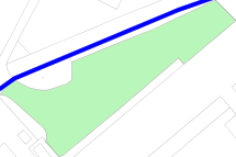
Current vehicle access/egress Currently on the Ballakermeen site, the only vehicular access is via the barrier controlled entrance located at the end of Westminister Drive. The location of this access point is shown on drawing 109 “Existing”.
- As vehicles enter the site through this barrier, they will take one of two paths, either straight out onto St. Catherines Drive, or they will turn left to move along the front of the school.
The usual reasons for turning left would be to either park in one of the designated parking areas (shown on drawing 109), or to drop off/pick up students. The only time anyone other than school staff is allowed to enter the site, is under special circumstances, such as children with mobility impairments getting dropped at school. These cases are very few in number, with the majority of vehicle drivers looking to drop students off, having to stop around the St. Catherines Drive area.
Once a vehicle driver has completed their business at the school, they are faced with the challenge of leaving the school grounds, and currently this can only be done by turning in the already congested road and then driving back along the front of the school.
The road along the front of the school is at points 5 metres wide, this coupled with the students walking freely in large numbers around the area can make it difficult for vehicles to safely manoeuvre along this road.
Current pedestrian access/egress and school bus routes In the mornings, 3 school busses enter the Ballakermeen site through the same barrier mentioned previous, at the end of Westminister Drive. They then proceed towards the exit onto St. Catherines Drive, stopping just before this exit, to allow students to get off the bus and walk towards the school. The busses then proceed onto St. Catherines Drive. The students that have left the bus will move up towards the school, some are looking to enter via the main entrance, and some are looking to use the smaller entrances spread along the school front. This means that students have the tendency to move along the road, and spread out making vehicular movements difficult. The other main point of access for pedestrians is the existing brick archway located at the end of Westbourne drive. Students will enter through this archway and are looking to enter the school in the same manner, again creating crowds along the school front road.
- At the end of the school day, these pedestrian patterns are reversed, with students exiting the school and moving back towards the bus parking, and brick archway, in the same spread out manner, again making two way vehicular movements unsafe. Proposed vehicular route changes
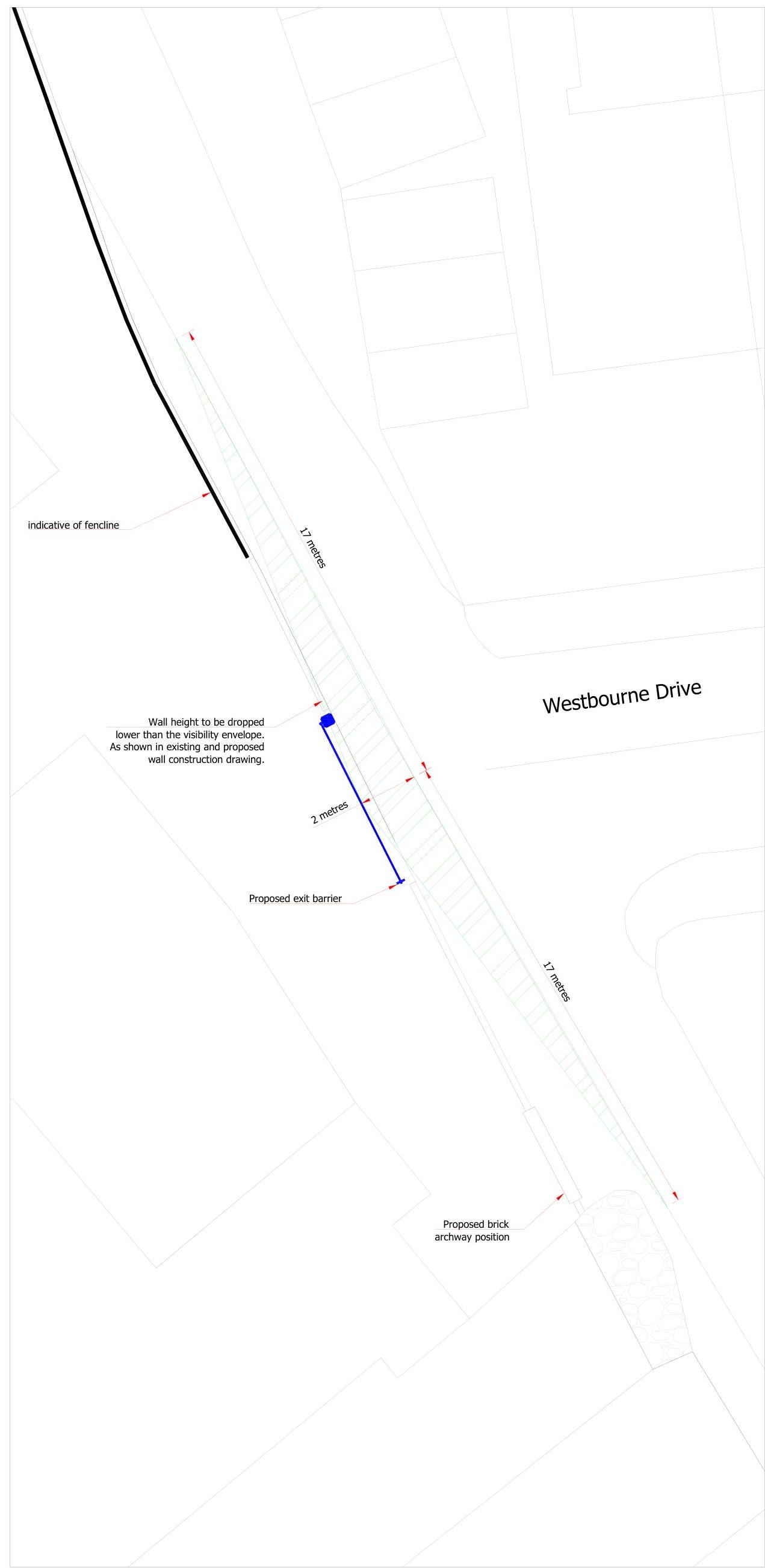
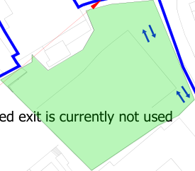
By implementing a new barrier controlled vehicle exit onto Westbourne Drive, vehicles will now be able to just move one way along the front of the school. This will mean that vehicle drivers will be able to avoid turning in a congested area, markedly improving conditions and safety, for drivers and pedestrians along the front of the school.
Busses will still follow the same path as previous, and vehicle access to the site will still be restricted and controlled by the existing entry barrier.
Only staff and certain parents of vulnerable students will be allowed to use the barrier, and access the school, and this will be unchanged from existing arrangements.
Safety of pedestrian movements on the school grounds are to be improved by the proposed speed tables, these serve a dual purpose of slowing vehicle movements, and giving students a raised table to cross the road on. This is to be coupled with education from the school on safe movements, and encouraging the use of the crossing points.
It is worth noting that the staff who will be using the exit onto Westbourne Drive leave in a staggered manner. This will be spread over the course of around 2 hours in the evening, and this will create a steady but ordered trickle of light traffic onto Westbourne.
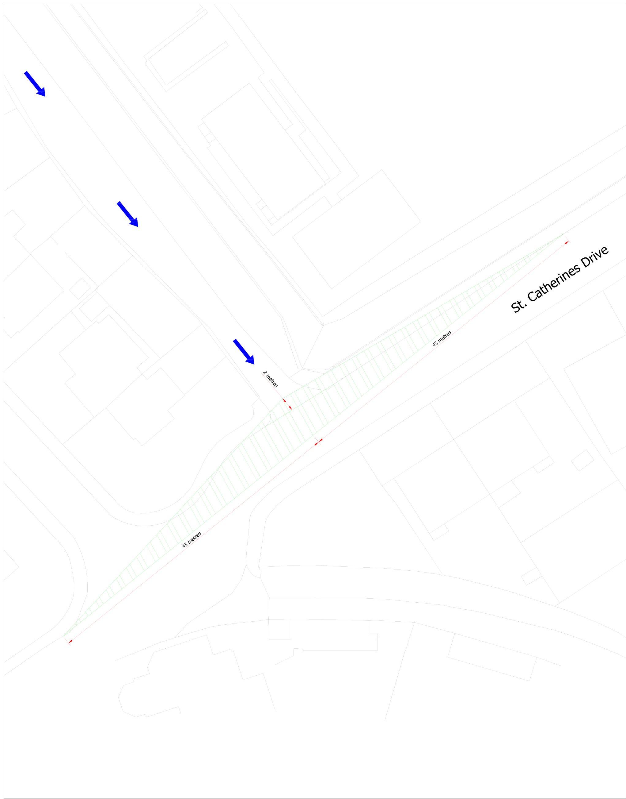
Parking and vehicle speeds The speed of the vehicles moving through the site is currently not an issue. The nature of difficult manoeuvring conditions makes for on average very low speeds. The proposed changes will make the road one way however, so to alleviate any potential increase in speed by the improvement of conditions, there are speed tables proposed. Currently there are 127 allocated parking spaces on the site, and this is not expected to change. Most of these spaces are full during the day, so it is reasonable to assume traffic numbers around this number each day. The amount of traffic using the site will remain unchanged, and there is no expectation to increase current parking capacity on the site. The existing exit onto St. Catherines Drive realistically does suffer from issues with visibility during the daytime operation of the school. There are a large number of cars parking either side of the road, making the road essentially a single lane. This makes it so vehicles don’t have the needed visibility when using this exit. The proposed exit onto Westminister Drive, will in reality, have improved visibility for vehicles, and create a safer environment for students on and around the site.
|43 metres
43 metres
2 metres
St. Catherines Drive|
|---|
|ST CATHERINE'S DRIVE
17 metres
2 metres
indicative of fencline
Wall height to be dropped
lower than the visibility envelope. As shown in existing and proposed
wall construction drawing.
Proposed exit barrier
|
|---|
## St
Proposed exit onto Westbourne Drive Scale 1:100
Existing exit onto St Catherines Drive scale 1:200
[Table omitted in markdown export]
ALBANY ROAD
SELBORNE DRIVE
SARTFELL ROAD
TENNIS ROAD
Path (um)
7 5
###### Ballakermen Close
3 1
ROAD
WESTMINSTER DRIVE
Wessex Garage
Existing pedestrian access and egress Gated exit is currently not used WESTBOURNE DRIVE AVENUE HAWARDEN Parking is spread along the length of the currently two way system, adding to the difficulty with maneuvring. Drivers have to turn on a small road congested with students. Vehicles enter school grounds from Westminister Drive. Schools only exit is St Catherines drive, which becomes congested with parents dropping students at the roadside
###### St Catherine'S Drive
### Key:
7 5
BALLAKERMEN CLOSE
3 1
Dreemskerry
ROAD
Trevear
Shaugh Cottage
Existing pedestrian access to be moved as shown on site plans
Tk
New exit will allow vehicles to exit the school grounds without having to turn around in
| |
|---|
Ballakermeen High School Boundary
| |
|---|
Parking areas
General arrangement of Existing Scale 1:1250 Direction of travel General arrangement of Proposed Scale 1:1250
---
*Data sourced from the Isle of Man public planning register under the [Isle of Man Open Government Licence](https://www.gov.im/about-this-site/open-government-licence/).*
*Canonical page: https://planningportal.im/a/12240-braddan-catherines-drive/documents/1308645*