**Document:** Mp Associates Appeal Statement
**Application:** AP24/0047 — Appeal against the approval for construction of 3 garages to plots 4 and 5 and foul drainage connection of previously approved and commenced development PA 20/00787/B and PA 19/01324/B
**Decision:** Appeal dismissed - PA APPROVED
**Decision Date:** 2025-02-11
**Parish:** German
**Document Type:** appeal / appeal_statement
**Source:** https://planningportal.im/a/88393-german-main-road-st-johns-appeal-against-approval/documents/1142211
---
# Mp Associates Appeal Statement
###### Appeal Statement
Ref: 23/00606/B Applicant: Mr Mark Pearce
Proposal: Appeal against the approval for construction of 3 garages to plots 4 and 5 and foul drainage connection of previously approved and commenced development PA 20/00787/B and PA 19/01324/B
Address: Field 314758 And 312909 Main Road St Johns Isle Of Man
###### Statement by the appellant:
The boundary as represented on plan 0725/PL103 Rev C12B that separates both plots 1& 2 from Mr & Mrs Davies's approved plot (plan 24/00276/REM ) is incorrect.
The legal document that establishes the boundary was requested by the planning officer to substantiate access for 24/00276/REM . As drawn 0725/PL103 Rev C12B has our garage partially on plot 1.
The applicant has had sufficient time and notice to correct the plan. There is also a clear gap between the access to plots 1&2 and Mr & Mrs Davies's private access lane to their plot which was not on earlier site plans which may also compromise their development. We consider this prejudices our approved application and is contrary to: Part (k) of GP2.
Reserved Matters application to PA 21/00365/A for the erection of a dwelling and garage with associated landscaping, addressing siting, landscaping, drainage, design, internal layout and external appearance.
The applicants planning approval is: PA 24/00276/REM Part Of Field 312909 Balladoyne Farm Main Road St Johns Isle Of Man
Statement by Ravenhill Resources Ltd the applicant: This issue is a boundary issue which is not a planning issue. The appeal should not have been accepted on these grounds. I have attached a plan by McGarrigle Architects Drawing no. 1853/02/P03 showing the sewer connection which is also the same as our connection on PA 23/00606/B which is agreed between the parties.
## M P
###### Associates
Architects & Interior Designers
12 Strathallan Crescent Douglas Isle of Man IM2 4NR
Tel: 01423 505070
Fax: 01423 505098 E: mp.associates@virgin.net Mark Pearce BA(Hons), Dip(Arch) RIBA Managing Director, Christine Pearce - Company Secretary M P Associates Limited. Registered in Isle Of Man No.90132C VAT No. 001 4928 13
I also attach the engineers drainage calculations and scheme entitled AXO360-NOT-1 Balladoyne Drainage which was approved by the MUA as part of this application.
The boundary as drawn on the scheme encompasses the works being carried out and therefore complies with the application.
The ownership boundary is different albeit Ravenhill Resources Ltd have a right of access across part of the field to access the sewer as shown on the drawings.
The fence to Mr & Mrs Davies’ plot is now the ownership boundary but when the original planning application was submitted it was not. This is why there is a slight difference in red line boundaries. It does not affect the application and encompasses the work which it is required to do.
Mr and Mrs Davies land was excluded from the various planning applications made by Ravenhill Resources Ltd and this does not affect the houses that are now underway.
This appeal is holding up the occupation of Plot 4 and 2 which are both near completion but cannot be completed or connected to the sewer whilst this appeal is ongoing.
Prepared by Mark Pearce BA(hons) Dip Arch RIBA
|existing trees
Gate
Post & Wire
Post & Wire
Bank Top
Bank Top
44.8
45.0
45.2
45.4
45.6
45.4 45.2
45.0
44.8
44.8
44.8
45.0
45.0
44.8
45.0 45.0
Bank Top
| | |
|---|---|
| | |
| | |
CONNECTION TO MH 9701 I.L. 41.010
WESTERN PLOT SEWER CONNECTION I.L. 41.080
proposed site plan
terrace
stone piers and gates
access lane road right of access
dwelling
garage and bicycle store
8 metres
6 metres
lawn
new trees
visitors car parking
new 2M high fence line
new hornbeam boundary hedge
new 2M high fence line
3.7 metres
low level shrub planting
low level shrub planting
new blackthorn boundary hedge
low level shrub planting
new hornbeam boundary hedge
new hornbeam boundary hedge
retain existing farm gate
reinforce existing manx bank with new planting
new hawthorn hedgerow
T1
T2
T3
T4
T5
T6
T2
key
new trees (Rowan)
existing trees
existing tree
existing tree
existing trees
existing tree
plot 1
plot 2
| | |
|---|---|
| | |
| | |
| | |
| | |
new hawthorn / blackthorn / hornbeam hedgerows
new low level shrub planting
existing tree removed
28.6M ACCESS LANE
kerbline
kerbline
4 metres
gravel set into reinforcement grids
concrete flat channel
13.5 metre radius
0 1m 5m 10m
SCALE
bin store area sw drain
| | |
|---|---|
| | |
sw drain
soakaway
soakaway
sw drain sw drain
fw drain
sw drain
field shelter to be removed
fw drain
7.5 metre radius
fw drain
6 metres
4.3 metre radius
6.17 metres
6 metres
sw drain
|x 44.700|
|---|
|x 44.700|
|---|
|x 44.800|
|---|
|x 44.700|
|---|
x 44.700
x 44.750
|x 44.850|
|---|
|x 44.700|
|---|
|x 44.700|
|---|
proposed levels
existing levels
19 Mount Havelock Douglas Isle of Man IM1 2QG tel. (01624)628141 email. info@mcgarrigle-architects.com
web. www.mcgarrigle-architects.com
McGarrigle architects
architects an urban esigners
||project title PROPOSED NEW DWELLING at BALLADOYNE, (FIELD 312909) MAIN ROAD, ST JOHNS at MR & MRS DAVIES|
|---|
|
|---|
|drawing title PROPOSED SITE PLAN|
|---|
rev date
notes copyright © 2023 McGarrigle Architects Ltd.
1 contractors must verify dimension before commencing shop or site work.
2 written dimensions to be taken in preference to scaled dimensions.
3 This drawing has been prepared for Statutory Planning Application purposes only and is not to be interpreted as a full working construction drawing.
| | |
|---|---|
|N| |
|scale 1:100 @A1|date nov 2023|drn by ms|chkd by NM|
|---|---|---|---|
|| | | | |
|---|---|---|---|
|1853
client no|02
job no|P-03
drg no|rev|
| | | | |
|
|---|
|
|---|
###### Contents
- 1 Introduction ..............................................................................................................................................................2
- 2 Relevant Standards ...................................................................................................................................................3
- 3 Drainage Calculations................................................................................................................................................4
- 4 Conclusion.................................................................................................................................................................5
- 5 References ................................................................................................................................................................5
- Appendix A – Drainage Arrangement Sketch....................................................................................................................6
- Appendix B – Butler Chart Extract ....................................................................................................................................7
###### 1 Introduction
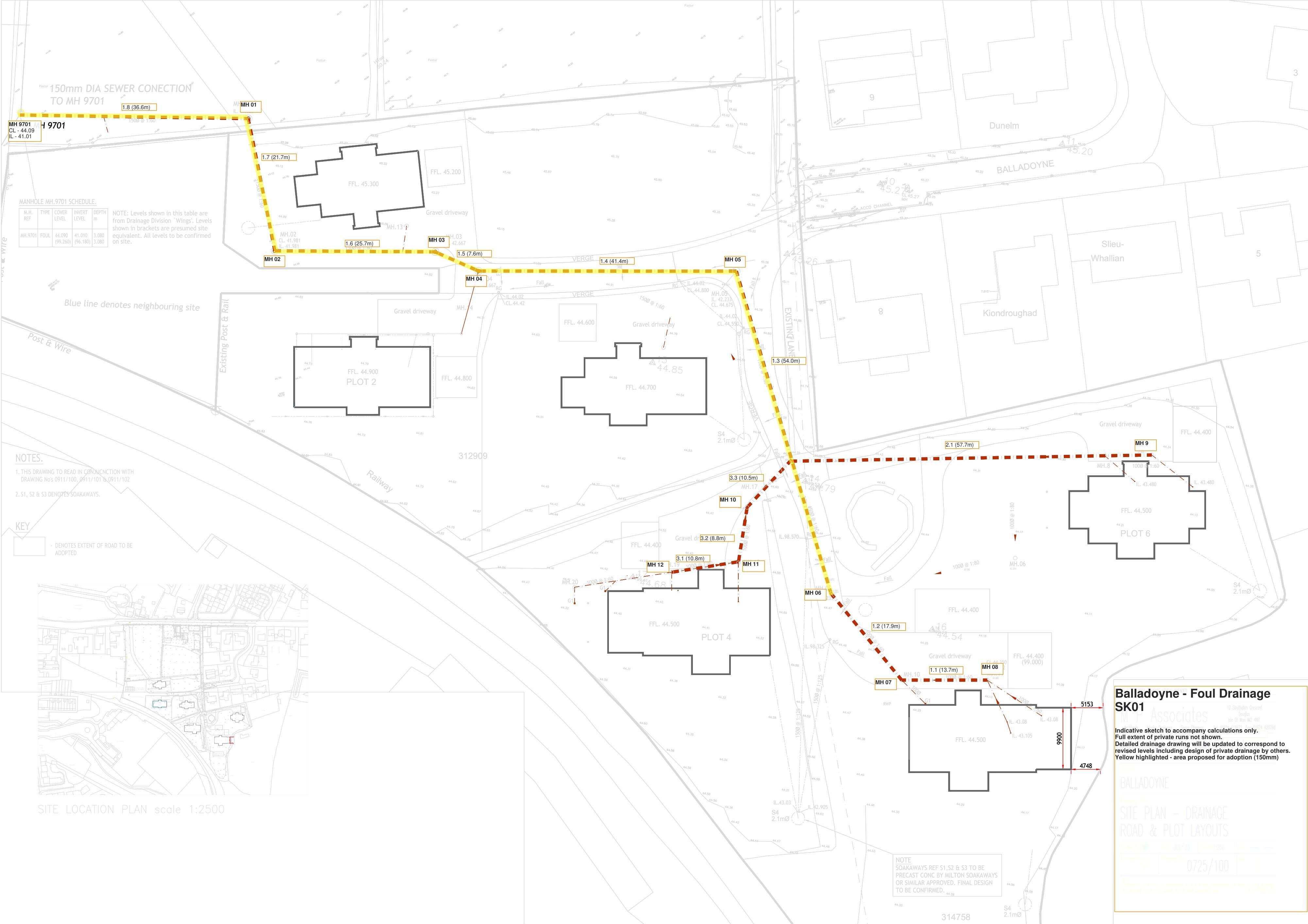
Axis Consulting Engineers Ltd have been requested to appraise the proposed foul drainage system at the Balladoyne development in St Johns, where 6 dwellings are being constructed.
The foul system connects into an existing Manx Utilities foul sewer system (at Manhole 9701), with invert level 41.01mAOD. The proposed system is intended for adoption.
Levels at the site are relatively flat and the distances to the existing sewer preclude a 1:60 fall across all runs on the new system, without significantly raising the proposed plots.
Figure 1 – extract from developer’s plans showing proposed development.
###### 2 Relevant Standards
Manx Sewers for Adoption [1] states the following:
Other relevant standards and code of practises are:
- - BS EN ISO 752-4 “Drain and sewer systems outside buildings” [2]
- - Sewers for Adoption 7th Edition (relevant code of practice England & Wales) [3]
###### 3 Drainage Calculations
Calculations have been undertaken in line with BS EN 752-4 and in accordance with Spons Urban Drainage Second Edition [4], flow rates have been calculated in accordance with discharge units [2] with associated probability factors.
|Start MH
End MH|Pipe Number|Maximum gradient (1 in)
Length (m)
Start IL (mAOD)
End IL (mAOD)
No of houses
Design flow rate (l/s)
Assumed pipe size|
|---|---|---|
|MH9701 1
|1.8 1.7 1.6 1.5 1.4 1.3 1.3 2.1 1.2 1.1 3.3 3.2|80 36.6 41.01 41.47 6 3.1 150 80 21.7 41.47 41.74 6 3.1 150 80 25.7 41.74 42.06 6 3.1 150
80 7.6 42.06 42.16 5 2.9 150 80 41.4 42.16 42.67 4 2.6 150 60 31.6 42.67 43.20 3 2.2 150 60 22.4 43.20 43.57 1 1.3 150 80 57.7 43.20 43.92 1 1.2 100/150 80 17.9 43.57 43.80 1 1.3 100/150 80 13.7 43.80 43.97 1 1.3 100/150 80 10.5 43.20 43.33 1 1.3 100/150
80 8.8 43.33 43.44 1 1.3 100/150
|
|1 2
2 3
3 4
4 5
5 5.1
5.1 6
5.1 9
6 7 7 8
5.1 10 10 11
|1.8 1.7 1.6 1.5 1.4 1.3 1.3 2.1 1.2 1.1 3.3 3.2|80 36.6 41.01 41.47 6 3.1 150 80 21.7 41.47 41.74 6 3.1 150 80 25.7 41.74 42.06 6 3.1 150
80 7.6 42.06 42.16 5 2.9 150 80 41.4 42.16 42.67 4 2.6 150 60 31.6 42.67 43.20 3 2.2 150 60 22.4 43.20 43.57 1 1.3 150 80 57.7 43.20 43.92 1 1.2 100/150 80 17.9 43.57 43.80 1 1.3 100/150 80 13.7 43.80 43.97 1 1.3 100/150 80 10.5 43.20 43.33 1 1.3 100/150
80 8.8 43.33 43.44 1 1.3 100/150
|
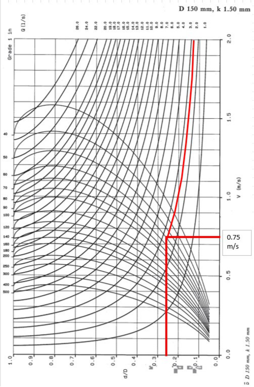
|Min flow for self-cleansing (0.75 m/s) using Butler charts = 2.6l/s [5]|
|---|
kdu 0.5 k 1.5 mm DU 6.6
Notes
|Discharge units
WC 2.5 wash basin 0.6
Sink 1.3 Washing machine 0.8 Shower 0.6 Dishwasher 0.8 Total 6.6
|
|---|
1. "MH 5.1" are junction connections into run 1.3 rather than MH adoption
- 1. "MH 5.1" are junction connections into run 1.3 rather than MH
- 2. Blue highlighted manholes are proposed for adoption
- 3. Grey text is proposed private drainage
- 4. Yellow highlighted falls - ran at 1:60 as insufficient flows to justify 1:80
- 5. Green design flow rate - sufficient design flow to achieve 0.75 m/s
- 3. Grey text is proposed private drainage
- 4. Yellow highlighted falls - ran at 1:60 as insufficient flows to justify 1:80
m/s
In summary where 4 or more houses are served calculations can justify a 1:80 fall at design flow. Where there is a lower flow than this it is recommended that a 1:60 fall should be implemented.
(All adoptable runs taken as 150mm minimum)
It should be noted that this is based on design flow rather than one third design flows (MSfA) and therefore may occur less frequently, although the proposed falls would be acceptable under Sewers for Adoption 7th edition with a smaller pipe diameter (higher frictional losses), based on empirical evidence.
###### 4 Conclusion
Based on the calculations it is proposed that runs 1.8, 1.7, 1.6, 1.5 & 1.4 could be laid at 1:80 falls whilst achieving selfcleansing velocities at design flows.
Consideration of floor levels in Plots 5 & 6 is required, and/or areas of private drainage may require concrete encasement to meet required levels – the developer has advised it is possible to accommodate proposed drainage levels. It is recommended that all private drainage and laterals are set to suitable falls to ensure a self-cleansing regime.
Adequate construction controls should be undertaken to ensure falls are maintained and there are no shallow areas or areas of settlement that may subsequently impact on the efficiency of the proposed drainage system.
###### 5 References
- [1] D. D. Division/WRc, “Manx Sewers for Adoption,” 2003.
- [2] B. Standards, “BS EN 752-4 Drain and sewer systems outside buildings. Hydraulic design and environmental considerations,” 2017.
- [3] WRc, “Sewers for Adoption 7th Edition - A Design & Construction Guide for Developers,” 2012.
- [4] Spons, “Urban Drainage, 3rd Ed,” 2017.
- [5] D. B. a. R. Pinkerton, Gravity flow pipe design charts, Thomas Telford.
###### Appendix A – Drainage Arrangement Sketch
Pastur
Pastur
Pastur
Pastur
Pastur
Pastur
##### 150mm DIA SEWER CONECTION TO MH 9701
Pastur
Pastur
Gate
Gate
150Ø @ 1:60
150Ø @ 1:60
###### Mh 9701
Dunelm
Dunelm
Gate
Gate
###### Balladoyne
- FFL. 44.900 FFL. 44.700
|FFL. 44.800FFL. 44.800
|
|---|
|FFL. 44.600FFL. 44.600
|
|---|
- FFL. 45.300
- FFL. 44.900 FFL. 44.700
- FFL. 45.300
150Ø @ 1:60
150Ø @ 1:60
Gravel driveway
Gravel driveway
|M.H.
REF
M.H.
REF|TYPETYPE
|COVER
LEVEL
COVER
LEVEL|INVERT
LEVEL
INVERT
LEVEL|DEPTH
m
DEPTH
m|
|---|---|---|---|---|
|MH.9701MH.9701|FOULFOUL|(99.260)
44.090
(99.260)
44.090|(96.180) 41.010 (96.180) 41.010
|3.080
3.080
3.080
3.080|
NOTE: Levels shown in this table are NOTE: Levels shown in this table are from Drainage Division `Wings'. Levels from Drainage Division `Wings'. Levels shown in brackets are presumed site equivalent. All levels to be confirmed on site. shown in brackets are presumed site equivalent. All levels to be confirmed on site.
Post & Wire
Post & Wire
###### Mh.03
Slieu-
Slieu-
150Ø @ 1:60
150Ø @ 1:60
Whallian
Whallian
Fall
Fall
Fall
Fall
Fall
Fall
###### Mh.04
Fall
Fall
Fall
Fall
###### Il. 42.667
RG
RG
RG
RG
Existing Post & Rail
Existing Post & Rail
150Ø @ 1:60
150Ø @ 1:60
###### Blue line denotes neighbouring site
Gravel driveway
Gravel driveway
###### Existing Lane
Kiondroughad
Kiondroughad
Gravel driveway
Gravel driveway
RG
RG
Post & Wire
Post & Wire
Fall
Fall
Fall
Fall
150Ø @ 1:60
150Ø @ 1:60
###### Verge
Fall
Fall
Fall
Fall
Gravel driveway
Gravel driveway
S4 2.1mØ
S4 2.1mØ
MH.9
MH.9
Fall
Fall
#### Notes.
MH.8
MH.8
100Ø @ 1:60
100Ø @ 1:60
- 1.THIS DRAWING TO READ IN CONJUCNCTION WITH DRAWING No's 0911/100, 0911/101 & 0911/102
- 2.S1, S2 & S3 DENOTES SOAKAWAYS.
Railway
Railway
Fall
Fall
Fall
Fall
100Ø @ 1:80
100Ø @ 1:80
150Ø @ 1:60
150Ø @ 1:60
#### Key
100Ø @ 1:60
100Ø @ 1:60
RG
RG
Gravel driveway
Gravel driveway
| |
|---|
- DENOTES EXTENT OF ROAD TO BE ADOPTED
Fall
Fall
Fall
Fall
100Ø @ 1:80
100Ø @ 1:80
100Ø @ 1:60
100Ø @ 1:60
Fall
Fall
100Ø @ 1:60
100Ø @ 1:60
S4 2.1mØ
S4 2.1mØ
G1
G1
Car
| |FFL. 44.400FFL. 44.400
| | |
|---|---|---|---|
|Gravel driveway
MH.10 100Ø @ 1:60 MH.11
43.482
IL 43.832
CL 44.350
Gravel driveway
MH.10 100Ø @ 1:60 MH.11
43.482
IL 43.832
CL 44.350|Gravel driveway
MH.10 100Ø @ 1:60 MH.11
43.482
IL 43.832
CL 44.350
Gravel driveway
MH.10 100Ø @ 1:60 MH.11
43.482
IL 43.832
CL 44.350|Gravel driveway
MH.10 100Ø @ 1:60 MH.11
43.482
IL 43.832
CL 44.350
Gravel driveway
MH.10 100Ø @ 1:60 MH.11
43.482
IL 43.832
CL 44.350|FFL. 44.400 (99.000) FFL. 44.400 (99.000)
|
Park
El
Church/chapel
Sub Sta
Fall
Fall
G1
G1
BM 47.24m
School House
The Royal Chapel of
Police
Glencar
St John the Baptist Ballahowin
House
House
Ivy Cottage
The Old
Church
Hall
Vicarage
46.3m
St John's
312703
PEEL ROAD
A 1
45.7m
Paved
TCB
100Ø @ 1:60
100Ø @ 1:60
Woodlands
Balladoyne
Rosshay
Kerrowdhoo
Farm
Pave
Pave
Church / Chapel
RG
RG
Westville
Rose Cottage
West Woodlands
Fall
Fall
East Woodlands
Fo Chronk
Methodist
St Johns School
Hall
312854
West
312858
View
Easdale
Reayrt Y
PUBLIC SEWER
Juys
150Ø @ 1:125
150Ø @ 1:125
Central Stores
150mm DIA SEWER CONECTION TO MH 9701
150Ø @ 1:60
MH 9701
Dunelm
BALLADOYNE
Willow Bank
100Ø
100Ø
- FFL. 44.900 FFL. 44.800
|FFL. 44.600|
|---|
|FFL. 44.700|
|---|
- FFL. 45.300
150Ø @ 1:60
Coach
REF
MH.9701
Gravel driveway
M.H.
TYPE COVER INVERT LEVEL
DEPTH
NOTE: Levels shown in this table are from Drainage Division `Wings'. Levels shown in brackets are presumed site equivalent. All levels to be confirmed on site.
m
House
House
Post & Wire
44.090 41.010
MH.03
(99.260)(96.180)3.080
Cottage
Slieu-
150Ø @ 1:60
Fall
Whallian
Fall
MH.04
100Ø @ 1:60
100Ø @ 1:60
Fall
Fall
RG
RG
Existing Post & Rail
150Ø @ 1:60
Blue line denotes neighbouring site
Gravel driveway
EXISTING LANE
Kiondroughad
Gravel driveway
RG
Post & Wire
Fall
Fall
150Ø @ 1:60
Sovereign
150Ø @ 1:125
150Ø @ 1:125
House
Fall
Fall
Gravel driveway
S4 2.1mØ
314762
MH.9
Fall
MH.8
100Ø @ 1:60
Railway
Fall
Fall
Pretoria Terrace
314759
100Ø @ 1:80
150Ø @ 1:60
100Ø @ 1:60
312721
RG
Gravel driveway
Fall
Fall
100Ø @ 1:80
100Ø @ 1:60
CF
Fall
100Ø @ 1:60
S4 2.1mØ
G1
Fall
100Ø @ 1:60
RG
Fall
Gravel driveway
(99.000)
CL 44.350
Def
IL 43.832
MH.11
MH.10
150Ø @ 1:125
100Ø @ 1:60
100Ø
100Ø @ 1:60
150Ø @ 1:125
St. Johns School
Farmers
S4
Arms
2.1mØ
(PH)
|PRECAST CONC BY MILTON SOAKAWAYS OR SIMILAR APPROVED. FINAL DESIGN TO BE CONFIRMED.
|
|---|
NOTE
SOAKAWAYS REF S1,S2 & S3 TO BE
YS N
2.1mØ
Cronk-ny-Biljyn
314761
330466
MAGHER VAY
S4
S4
2.1mØ
2.1mØ
|SOAKAWAYS REF S1,S2 & S3 TO BE PRECAST CONC BY MILTON SOAKAWAYS OR SIMILAR APPROVED. FINAL DESIGN TO BE CONFIRMED.
NOTE
SOAKAWAYS REF S1,S2 & S3 TO BE PRECAST CONC BY MILTON SOAKAWAYS OR SIMILAR APPROVED. FINAL DESIGN TO BE CONFIRMED.
NOTE|
|---|
S4 2.1mØ
S4 2.1mØ
###### Appendix B – Butler Chart Extract
---
*Data sourced from the Isle of Man public planning register under the [Isle of Man Open Government Licence](https://www.gov.im/about-this-site/open-government-licence/).*
*Canonical page: https://planningportal.im/a/88393-german-main-road-st-johns-appeal-against-approval/documents/1142211*