**Document:** Flood Risk Assessment
**Application:** 25/90506/B — Variation of condition 1 of 23/00774/B to extend the expiry date by two further years
**Decision:** Permitted
**Decision Date:** 2025-07-16
**Parish:** Malew
**Document Type:** report / flood_risk_assessment
**Source:** https://planningportal.im/a/34152-malew-former-whitestone-garage-extension/documents/1086852
---
# Flood Risk Assessment
## Flood Risk Assessment
Whitestone Garage
AX0276
DECEMBER 2023
Axis Consulting Engineers
### Contents
- 1. Introduction................................................................................................................................... 3
- 2. Topography.................................................................................................................................... 5
- 3. Historic use .................................................................................................................................... 6
- 4. Existing surface water management ............................................................................................. 7
- 5. Existing foul water management................................................................................................... 8
- 6. Proposed development ................................................................................................................. 9
- 7. Comparison of surface areas ....................................................................................................... 11
- 8. Flooding from rivers (fluvial) and tidal sources........................................................................... 11
- 9. Flooding from surface water (pluvial) ......................................................................................... 12
- 10. Flood risk from sewers................................................................................................................. 12
- 11. Other sources............................................................................................................................... 12
- 12. Proposed surface water management ........................................................................................ 12
- 13. Proposed foul water management.............................................................................................. 13
- 14. Probability of Flooding................................................................................................................. 14
- 15. Strategies for flood mitigation..................................................................................................... 18
- 16. Recommendation ........................................................................................................................ 20
- 17. Conclusion.................................................................................................................................... 20 References .............................................................................................................................................. 22
## 1. Introduction
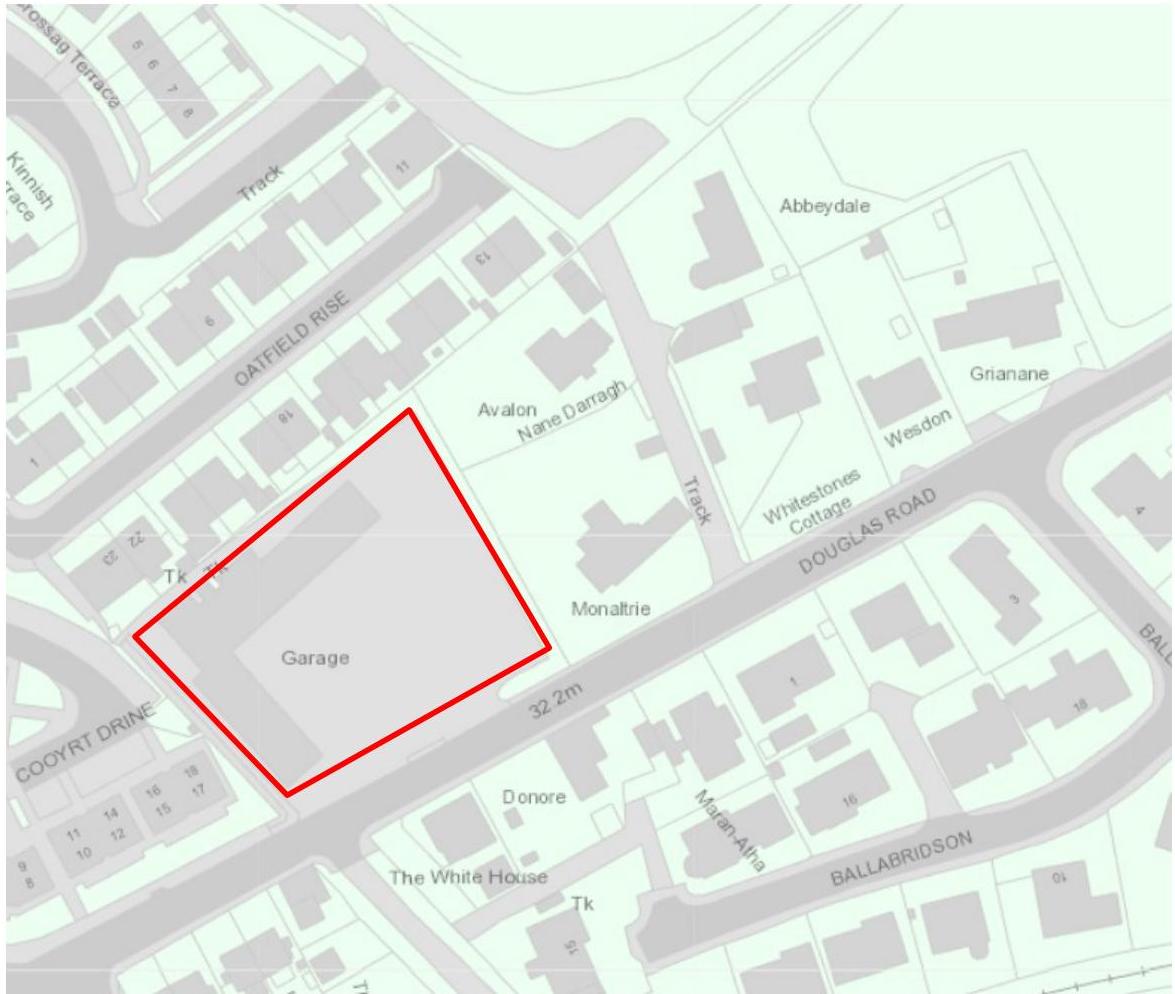
- 1.1 Axis Consulting Engineers have been commissioned to undertake a Flood Risk Assessment on the site of the old Whitestone Garage in Ballasalla, to support a planning application for development (PA 23/00774/B).
Figure 1 - Location of the site
- 1.2 The proposed 0.37 ha development is located on the approach to Ballasalla from the Douglas direction. At this stage the application is for approval in principle and sets out provision for a retail facility.
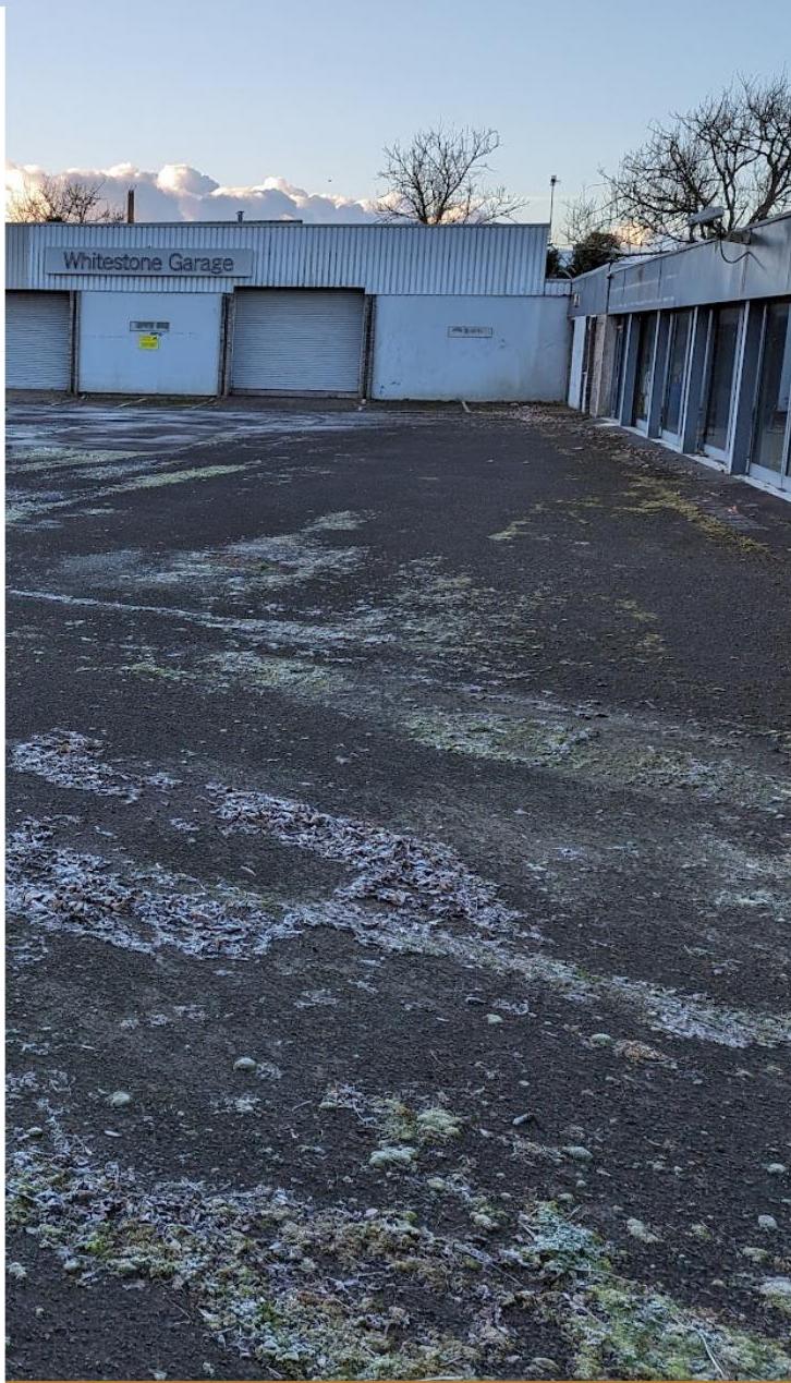
- 1.3 The site currently consists of an area of hardstanding, with a set of buildings that formed the previously operating car showroom and garages. The site is bordered by residential properties in Oatfield Rise to the north, two properties to the east, a ditch on the west (with the Clagh Vane estate on the other side) and the A5 Douglas Road to the south.
Figure 2 - current site, with the garage buildings, car showroom and associated forecourt/parking areas
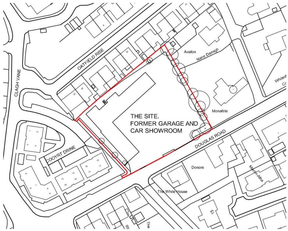
- 1.4 A culvert runs along the northern boundary, from an inlet approximately 50m from the northeastern edge of the site and runs into the open ditch section on the western boundary. At the Douglas Road end, this then continues parallel the road to a culvert under the main road towards the southwest of the site (see Figure 3).
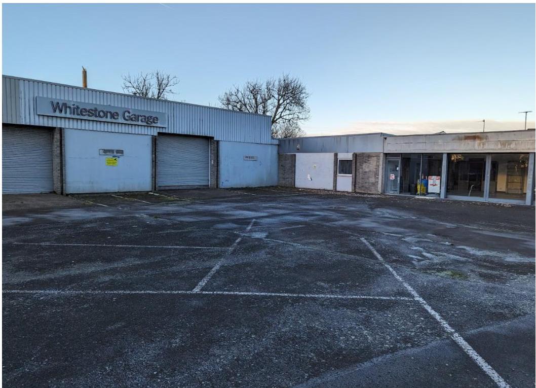
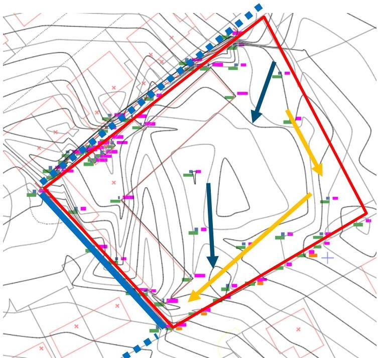
Figure 3 - wider location plan, showing site area (red), the watercourse (open sections solid blue line, culverted sections dashed dark blue line). Arrows indicate direction of flow, with 1m contours shown and road gullies as square symbols.
## 2. Topography
- 2.1 The development site falls towards the southern corner the site, as shown in Figure 3.
- 2.2 Levels on the site vary from around 32.7 (northern corner) to 31.3 (A5 southern tie in) mAOD.
- 2.3 The approximate calculated catchment for the culvert at the eastern edge of the site is 20.5 hectares. The majority of this catchment is agricultural land, with a small number of properties within this area.
## 3. Historic use
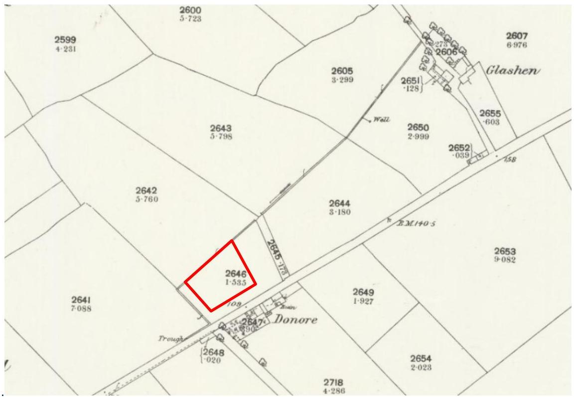
- 3.1 The 1869 Ordnance Survey [1] shows the site as a field, with the watercourse in place as a marked ditch.
.
Figure 4 - extract from the 1869 Ordnance Survey, with the site boundary shown in red.
- 3.2 The adjacent Oatfield Rise and the Whitestone Garage first appear on the 1980s Ordnance Survey map, at which time the culvert across the rear of the site would have been constructed.
Figure 5 - 1980s Ordnance Survey, with the site boundary shown in red.
## 4. Existing surface water management
- 4.1 The hardstanding areas and buildings are positively drained. Gullies collect the flows from areas of hardstanding, with an additional drainage channel across the entrance onto the A5. The building roofs are collected with suitable guttering and rainwater pipes.
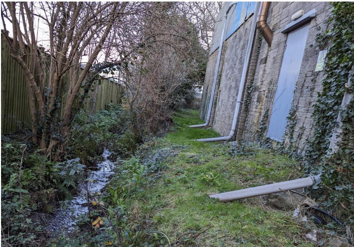
- 4.2 The rainwater pipes on the western side of the buildings were observed to route into the adjacent watercourse. It is assumed other site surface water drainage also discharges into the ditch (with the vegetation cover it was not possible to inspect for all outfalls).
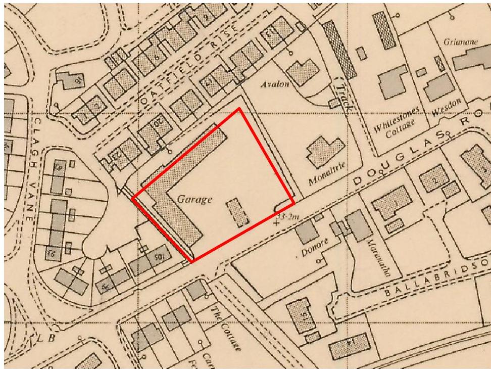
Figure 6 - Existing downpipes discharging to ditch.
## 5. Existing foul water management
5.1 There is an existing foul sewer running down Douglas Road. It is assumed that site foul flows discharge into this sewer.
## 6. Proposed development
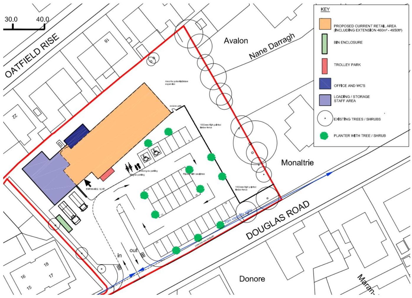
- 6.1 The proposed development is for approval in principle to establish a retail area with associated parking. The access is off the A5 Douglas Road, at the southern end of the site.
- 6.2 The car parking and associated hardstanding areas are circa 1750 m2.
- 6.3 As the application is for approval in principle only at this stage, it has not yet been established whether areas of the building footprint and hardstanding areas will be re-used, or whether the site will be reconstructed. This detail will be developed in subsequent stages.
- 6.4 The building areas are circa 640 m2 (with circa 170m2 indicated for potential subsequent extension). It has not been established at this stage which areas are planned for landscaping surfaces – this should be confirmed as part of the subsequent design stages and discussions with Flood Risk Management when agreeing appropriate attenuation and s20 license (if new outfalls or changes are proposed).
#### Compatibility with policy
- 6.5 The site is within the existing town boundaries. The proposals align with the Strategic Plan [2] that sets out that “Developments should make the best use of resources by optimising the use of previously developed land”.
- 6.6 Redeveloping sites ahead of new development area aligns with the “Sequential Approach” to flood management set out in the Draft Planning Policy Statement [3].
- 6.7 Whilst the draft planning policy statement gives only a high level overview of vulnerability classifications, assessing against UK Planning Policy Statement 25 [4], the proposed development would relate to a ‘Less Vulnerable’ category in accordance with Annex D.
- 6.8 The Draft Planning Policy Statement sets out that “Development within Flood Zones … may be permitted, provided it can be demonstrated that the site has the appropriate level of flood protection, and that the development will not increase the probability of flooding to the surrounding environment.”
## 7. Comparison of surface areas
- 7.1 As the application is at approval in principle stage, the extents of permeable and impermeable surfaces have not been established.
- 7.2 Noting the extents of the current site hardstanding areas, with the buildings footprint and areas of asphalt covering the full site with the exception of a rear grassed access area, it is anticipated that impermeable area will be either the same or less than in the existing condition.
## 8. Flooding from rivers (fluvial) andtidal sources
- 8.1 The primary flood risk within the area is fluvial, from the adjacent watercourse.
- 8.2 A previous study [5] by the Isle of Man Water and Sewerage Authority (WSA) on the Ronaldsburn Stream identified the areas adjacent to this watercourse as a flood risk.
- 8.3 The primary driver for the flood risk is the lack of culvert capacity and sensitivity testing for culvert blockages.
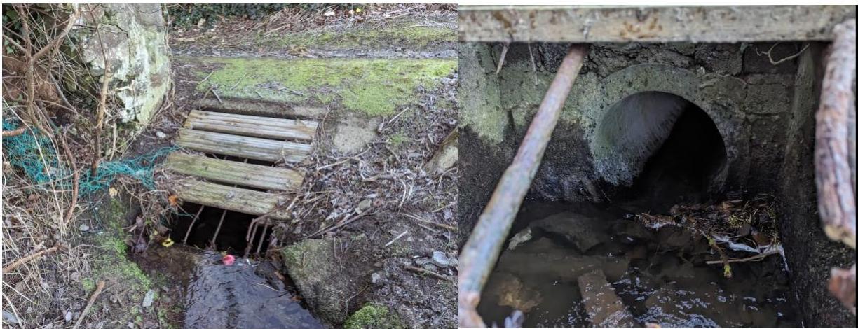
- 8.4 The culvert adjacent to Oatfield Rise (300mm pipe) is at the greatest risk of flooding, and there have been historic incidents of flooding occurring in the vicinity of the culvert screen. A flood event was recorded in 2002 (noted in the WSA commissioned report [5]), and anecdotal reports from residents suggest the immediate area around the culvert surcharges around twice yearly, with relatively frequent cleaning of the debris screen required (Figure 7).
Figure 7 - culvert inlet to the north of the site, adjacent to Oatfield rise and the football club.
## 9. Flooding from surface water (pluvial)
- 9.1 The site is currently hard standing. There is positive drainage which likely discharges to the adjacent ditch. The site also falls to the Douglas Road end. There is channel drainage across the entrance to the road.
- 9.2 It is not known the capacity of the existing drainage system; however, the proposals indicate a reconfiguration of this area, and it is therefore anticipated at detailed design drainage surveys would be undertaken.
## 10. Flood risk from sewers
- 10.1 There is no known risk from the existing sewers in the area as advised by Manx Utilities.
- 11. Other sources
- 11.1 Risk of groundwater flooding is minimal due to the close proximity to the watercourses and the raised site level. The superficial geology in the area is mostly drift deposits which are relatively impermeable, with bands of sands and gravels.
- 12. Proposed surface water management
- 12.1 Surface water will be positively drained from buildings and areas of hardstanding, as in the present condition, and discharged into the adjacent watercourse.
- 12.2 Details of the outfall and any associated attenuation will be agreed with Flood Risk Management as part of any Section 20 application during detailed design, and existing arrangements surveyed to verify potential for re-use.
## 13. Proposed foul water management
- 13.1 Foul services are proposed to connect into the existing sewer on Douglas Road. It is anticipated the existing building connects to this sewer and it may be possible to reuse the site connection subject to confirmation of size and suitability.
- 13.2 Levels, falls and exact manhole arrangements will be set in the detailed design.
Figure 8 - extract from plans provided by Manx Utilities. Brown indicates foul system, blue indicates surface water system and red indicates combined system.
## 14. Probability of Flooding
- 14.1 The site lies in an area of flood risk, due to the watercourse that comes from near Glashen Farm, traverses the northern and western edges of the site, and continues adjacent and under the Douglas Road to form the subsequent Ronaldsburn Stream.
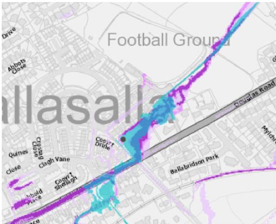
- 14.2 The Flood Hub’s flood risk map [4] show the site at risk of fluvial flooding (Figure 9), in 30 year storm events and in more severe events.
Figure 9 – extract from the Flood Hub’s flood risk maps, with the site shown by the grey dot.
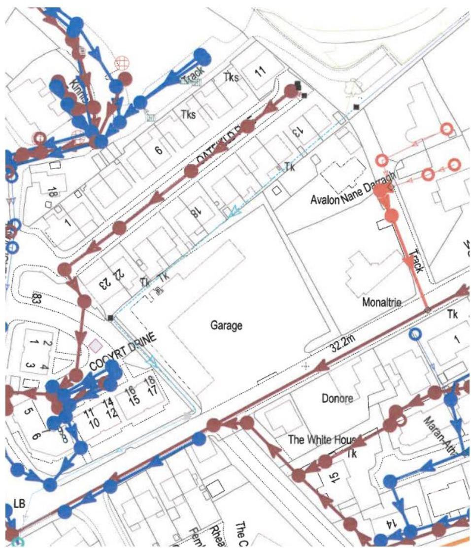
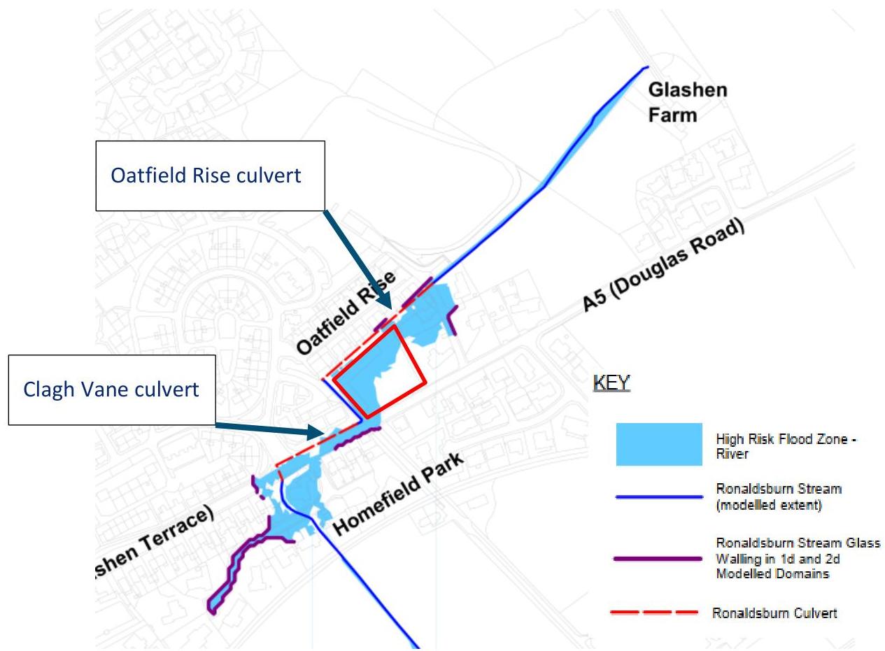
- 14.3 In addition, a WSA commissioned study [4] reviewed the Ronaldsburn area in particular and identified the following area as at risk of fluvial flooding.
|Oatfield Rise culvert|
|---|
|Clagh Vane culvert|
|---|
Figure 10 - extract from WSA commissioned report, site boundary in solid red.
- 14.4 The WSA commissioned report [5] assessed culvert capacity, risk of blockage and modelled catchment flows to provide the above analysis.
- 14.5 The primary flood risk is associated around the inlet to the Oatfield Rise culvert, the report identified the following capacity and predicted flow:
Figure 11 - extract from WSA commissioned report.
- 14.6 It should be noted that the report identified further survey works would be required to confirm overland flow paths through the area, however this does broadly match anecdotal evidence from local residents who suggested previous flood events (including the 2002 event listed in the report) have seen flow from
[Table omitted in markdown export]
the watercourse travel through the grounds of the adjacent property Nane Darragh (and possibly parts of Monaltrie), and then onwards through the site area down to the southern corner of the site.
- 14.7 The above flood maps, and levels surveyed on site (Appendix A – Levels in Area), suggest two properties are at risk of flooding (with corresponding floor levels) – Abbeydale (36.2 mAOD), Nane Darragh (34.9m AOD). A further property, Monaltrie, is vulnerable to flooding (35.2 mAOD, possibly airbrick at 35.0 mAOD) subject to the exact flow path which additional surveys would be required to establish. Whitestone Cottages has a significantly elevated floor level and is therefore not anticipated to be at risk of flooding, although there is a risk to garden areas and associated outbuildings. The adjacent Oatfield Rise and Cooyrt Drive areas are not anticipated to be at risk of flooding.
Figure 12 - properties adjacent to the site
- 14.8 The development site plays a role in relation to potential flooding to these properties. If flows in flood condition were restricted from onward flow through the site, the probability of these properties flooding would increase.
- 14.9 Previous modelling indicates overland flows would exit the site onto Douglas Road. Despite the presence of the adjacent ditch, other than site drainage (which could only be relied on to convey a small proportion
- of flows), there is no route into this ditch due to the presence of a solid wall and the site topography channelling flows towards the road. It is not believed there are grips on the road although it is anticipated that highway drainage is connected to the culvert.
- 14.10 The existing building on the site has a threshold of around 32.7m AOD. This is slightly raised from adjacent ground but noting the fall of the site (north to south) there is anticipated to be some risk to the property. The property is believed to have a solid floor, and a consistent floor level across the site.
- 14.11 Douglas Road is therefore at risk of flooding in the current condition. Previous modelling suggests properties adjacent to the road and around Homefield Park may be at risk of onwards flooding.
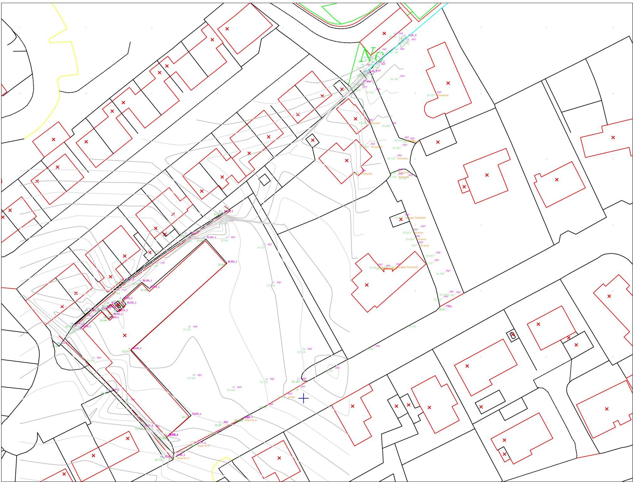
- 14.12 As part of this assessment, levels have been taken at adjacent properties and across the garage site. This broadly support the results of the above modelling output.
- 14.13 The levels at the culvert inlets were 30.7m AOD (Douglas A5 culvert) and 34.8m AOD (Oatfield Rise). The ditch carrying the watercourse at the western edge of the site is around 950mm lower than the adjacent bank.
- 14.14 There is also flood risk associated with the culvert under Douglas Road (Figure 11), however the culvert is estimated to have the capacity for the 1 in 100 year flow (although due to the issues identified previously, with the Oatfield Rise culvert surcharging only a proportion of total flows will enter the Douglas Road culvert, with the rest travelling overland). If this culvert were to surcharge it is anticipated flows would generally travel down Douglas Road, which is at a lower level (circa 31.3 mAOD) than the site and which the general area falls toward.
## 15. Strategies for flood mitigation
Increased threshold heights
- 15.1 Noting the risk of overland flow it is recommended that any floor level has a raised threshold entry to mitigate risk of property damage – if the site is reconstructed it would be recommended to achieve a freeboard of 600mm [7] above predicted flood level (which could be assessed using the flows from the WSA commissioned report [5]). Noting the relatively moderate size of the catchment area, and that the building is raised from wider surrounding topography, it may be prudent to relax this freeboard requirement to 300mm.
- 15.2 The development threshold is currently slightly raised over external areas (however is unlikely to provide a freeboard of more than circa 100mm), therefore if the existing building is retained additional property level protection should be considered.
- 15.3 The overland flows modelled in the WSA commissioned report [5] are anticipated to be relatively modest (at a maximum of 0.29 m3/s) and the existing hardstanding areas will easily convey flows across the site. The risk to car parking areas is relatively low with any flooding in extreme events likely to be less than 200mm in depth. A full topographical survey would confirm the existing flow path in the site and inform the required threshold level, which could be established to allow a sufficient freeboard above the maximum predicted flood level.
Provide property level protection
- 15.4 If the existing threshold height is insufficient to establish required freeboard above maximum flood level, and subsequent design stages decide to re-use the site rather than rebuilding, the existing building could be protected with property level protection. This could be in the form of walls to channel flows away from the building, or protection to doors. A detailed property risk assessment should be prepared if this is pursued to ensure protection has been adequately considered.
Consider overland flows
- 15.5 An important consideration is that any grading changes to the site, or any new solid walls should consider the impact on the overland flows and ensure that the site is still capable of receiving these flows. Any solid walling at the northern boundary or equivalent bunds would be anticipated to worsen the flooding condition of the adjacent properties.
- 15.6 There may also be an opportunity for improving the routing of overland flows if the site is being regraded (Figure 13). These flows could be diverted into the existing ditch and culvert that run parallel to the Main Road, rather than onto the road itself, reducing a source of highway flooding and risk to properties across the road.
###### Figure 13 - current approximate flow paths (navy arrows) through the site, utilising coarse LiDAR data with infill surveyed points. Red – site boundary. Blue – Watercourse (culverted where dashed). Orange arrows show potential opportunity to divert flows back into the watercourse if the site was regraded.
Reconstruct or alter culverts
- 15.7 It is noted that the flood risk is largely associated with the undersized and blockage prone culverts (and primarily the culvert bordering Oatfield Rise). The WSA commissioned report [5] identified various options for improving this situation, such as reconstruction of the culverts, additional bunds to create storage and improving the screen to reduce risk of blockages.
- 15.8 It is not anticipated that this is feasible as part of this project due to the various landowners involved and substantial works required. The problem area is outside the site boundary and this assessment demonstrates that flood risk within the site can be safely managed, therefore provided there is no worsening of flood risk in the wider area any further improvements are outside the scope of this development.
## 16. Recommendation
- 16.1 The proposed development should ensure that building thresholds have adequate freeboard (400mm freeboard for commercial buildings) over predicted flood levels or provide property level protection. Noting the status of the application as approval in principle, confirmation will be required at the following design stage depending on whether the existing buildings and areas of hardstanding are modified or whether the site is redeveloped in its entirety.
- 16.2 Adequate consideration should be given to the overland flows noting the risk to adjacent properties. Provision should be made for ensuring flows can convey across the site.
- 16.3 The development is at approval in principle stage, and it has not yet been established whether existing hardstanding areas and surface water systems will be retained within the site. In subsequent design stages this should be confirmed, and levels of attenuation agreed with the Flood Risk Management team to ensure compatibility with policy and that surface water flows are managed appropriately.
## 17. Conclusion
- 17.1 The proposed redevelopment sits in an area at risk of flooding due to the culvert adjacent to Oatfield Rise, which has insufficient capacity and is prone to blockages in its current arrangement.
- 17.2 The flood risk is primarily from overland flows associated with this watercourse during flood events, where flows pass through the site and onto Douglas Road. The site has a relatively constant fall and therefore is not believed to provide storage.
- 17.3 The flood risk within this site can be safely managed through appropriate threshold levels and/or property level protection. The threshold level and available freeboard should be established during subsequent design stages.
- 17.4 The flood risk to adjacent properties will remain unchanged provided detailed proposals do not inhibit the ability of the site to convey excess overland flows from the northern corner, and through the site.
- 17.5 If detailed proposals identify the site will be fully reconstructed, there may be opportunity for some improvement to the wider area by conveying overland flows back into the watercourse rather than onto Douglas Road. This would reduce flood risk to the highway and adjacent properties to the south of the site. The culverted watercourse adjacent to Clagh Vane is believed to have sufficient capacity although some surcharging may be witnessed in 1 in 100 year flood events including climate change allowance.
- 17.6 Noting the length of the culvert, land ownership issues, and relevant influence on the site on local flood risk it is not practical to improve the wider capacity issues with the Oatfield Rise culvert.
- 17.7 Site discharge arrangements are anticipated to be similar to the current arrangements, with surface water discharging to the watercourse and foul discharging to the sewer on Douglas Road. The requirement and sizing for attenuation should be confirmed with Flood Risk Management at subsequent design stages following establishment of impermeable areas and confirmation of whether existing systems are suitable and/or will be reused.
## References
- [1] O. Survey, "1868/9 Map of the Isle of Man," [Online]. Available: https://maps.nls.uk/os/6inchengland-and-wales/isle_of_man.html.
- [2] C. Office, "Isle of Man Strategic Plan," 2016. [Online]. Available: https://www.gov.im/media/1350906/the-isle-of-man-strategic-plan-2016-approved-plan15_03_16.pdf.
- [3] DLGE, "Draft Planning Policy Statement," 2017. [Online]. Available: https://www.gov.im/media/633689/050809devel.pdf.
- [4] H. a. C. Department for Levelling Up, "Planning Policy Statement 25: Development and Flood Risk
- Practice Guide," [Online]. Available: https://assets.publishing.service.gov.uk/.
- [5] H. Consulting, "Ronaldsburn Stream - Technical Memorandum - Flood Study," Isle of Man Water and Sewerage Authority, 2013.
- [6] I. F. Hub, "Flood Risk Maps," [Online]. Available: https://iomfloodhub.im/maps-data/flood-riskmaps/.
- [7] CIRIA, "C624 Development and flood risk guidance," 2004.
- [8] CIRIA, "SuDS Manual (C753)," 2015. [Online].
## Appendix A – Levels in Area
|BLDG_1
BLDG_1
BLDG_1
BLDG_1
BLDG_1
BLDG_1
BLDG_1
BLDG_1 BLDG_1
BLDG_1
BLDG_1 BLDG_1
BLDG_1 BLDG_1
32.641
BLDG_1
BLDG_1
WALL_1
WALL_1
WALL_1
WALL_1
WALL_1
33 PNT 32.365
32 PNT 32.512
34 PNT 32.347
31 PNT 32.568
35 PNT 32.125
31 PNT 32.685
36 PNT 31.956
30 PNT 32.685
29 PNT 32.525
28 PNT 32.384
23 PNT 32.685
27 PNT
29 PNT 32.641
26 PNT 32.616
23 PNT 33.011
25 PNT 32.772
24 PNT 33.028
25 PNT
24 PNT 33.314
37 CLW_1
37 CLW_1
CLW_1
CLW_1
40 CLW_2
40 CLW_2
CLW_2
42
34.896
43 OTF
34.828
44 PNT
35.957
48 PNT
44 PNT 36.29
47 PNT 36.135
47 PNT 36.091
45 PNT 36.341
45 PNT
36.384
46 PNT
36.138
46 PNT 36.291
1
32.229
2 BLDG_1
31.937
3 BLDG_1 32.236
4 BLDG_1 32.671
5 BLDG_1 32.644
6 BLDG_1 32.667
7 BLDG_1 32.499
8 BLDG_1 32.597
9 BLDG_1
32.578
10 BLDG_1
32.702
11 BLDG_1 32.81
12 BLDG_1 32.58713 BLDG_1
32.473
14 BLDG_1 32.59815 BLDG_1
32.641
16 BLDG_1 32.51
17 BLDG_1 32.363
18 WALL_1 33.252
19 WALL_1 33.21
20 WALL_1 33.839
21 WALL_1 34.128
22 WALL_1 35.089
37 CLW_1 31.029
37 CLW_1 31.145
38 CLW_1 31.584
39 30.716
40 CLW_2 35.54
40 CLW_2 35.466
41 CLW_2 35.58
PNT 32.25
PNT 33.187
PNT 35.806
PNT 32.013
PNT 32.403
PNT 32.746
PNT 33.031 gulley
PNT 33.24
PNT 33.873
PNT 36.133
PNT 35.931
PNT 36.156
PNT 34.933 threshold
PNT 35.108 Threshold
PNT 34.983 Threshold
PNT 35.702
PNT 34.534
PNT 35.389
PNT 35.768
PNT 35.432 Entrance
PNT 35.422 Entrance
PNT 35.445 Entrance
PNT 35.407
PNT 35.496 Entrance
PNT 35.333 Garage Threshold
PNT 35.434
PNT 35.5 Entrance
PNT 35.623 Entrance
PNT 35.638 Entrance
PNT 35.6 Entrance
PNT 35.521
35.181
PNT 36.207 Threshold
PNT 35.722
PNT 35.687
PNT 35.687
PNT 35.786
PNT 35.6
PNT 35.65
PNT 35.781
PNT 35.789
LINE_1
LINE_1 Road tie in
LINE_1
CLW_1
LINE_1 31.32 Road tie in
LINE_1 31.697
LINE_1 32.405 Road tie in
PNT 34.98 Airbrick
PNT 35.209 Threshold
PNT 35.234 Garages Threshold|
|---|
---
*Data sourced from the Isle of Man public planning register under the [Isle of Man Open Government Licence](https://www.gov.im/about-this-site/open-government-licence/).*
*Canonical page: https://planningportal.im/a/34152-malew-former-whitestone-garage-extension/documents/1086852*