**Document:** Certificate of Lawfulness
**Application:** 25/00439/LAW — Certificate of Lawful Use as a House in Multiple Occupation
**Decision:** Certificate of Lawful Use/Devel Approved
**Decision Date:** 2025-07-31
**Parish:** Braddan
**Document Type:** decision / certificate_of_lawfulness
**Source:** https://planningportal.im/a/34028-braddan-ardlui-guesthouse-dwelling/documents/1085156
---
# Certificate of Lawfulness
Reference: 25/00439/LAW
#### Town And Country Planning Act 1999 Certificate Of Lawful Use Or Development
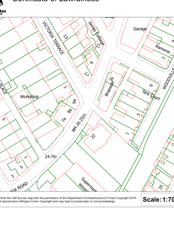
The Department of Environment, Food and Agriculture hereby certifies that on the 9th June 2025, the use described in Schedule 1 to this certificate in respect of the land specified in Schedule 2 to this certificate and edged REDon the plan attached to this certificate, was lawful within the meaning of section 24 of the Town and Country Planning Act 1999 for the following reason(s):
1) There is sufficient evidence to demonstrate that the HMO in the submitted information has been in situ since at least 2004.
- Schedule 1. Uses/Development to which this Certificate relates
For the use of the building as a House in Multiple Occupation.
- Schedule 2. The land to which the Certificate relates
Ardlui Guesthouse 4 Woodville Terrace Douglas Isle Of Man IM2 4HA
Date 1st August 2025 This decision was made by the Head of Development Management under the delegated authority afforded by Government Departments Act 1987.
S BUTLER S Butler MRTPI Head of Development Management
Notes
- 1. This certificate is issued solely for the purpose of section 24 of the Town and Country Planning Act 1999.
- 2. It certifies that the use specified in Schedule 1 taking place on the land described in Schedule 2 was lawful, on the specified date and, thus, was not liable to enforcement action under section 26 of the 1999 Act on that date.
- 3. This certificate applies only to the extent of the use described in Schedule 1 and to the land specified in Schedule 2 and identified on the attached plan. Any use which is materially different from that described or which relate[s] to other land may render the owner or occupier liable to enforcement action.
|VIC T O
RIA PLA CE
TaraCourt
W
O
O
D
VILLE
T
E
R
R
A
C
E
Braeside
Ja mes Co tage
VIC T O
RIA TE R R A CE
BM
26.25
m
Workshop
Garage
24.7m
Ramona
Works
7a
8a
9
a
5
13
7
22
1
28 3
35
53
17
24
6
30
41
2
9
1
5
1
3
9
Shop
1
1
1
11
26
4
Supermark
Winerit
ORIAROAD
rage
Reproduced from the IoM Survey map with the permission of the Department of Infrastructure © Crown Copyright 2015. Unauthorised reproduction infringes Crown Copyright and may lead to prosecution or civil proceedings.
Certificate of Lawfulness
|Scalebar:|
|---|
Department Division/Office Case Reference
Date
|Scale:1:702|
|---|
|
|---|
---
*Data sourced from the Isle of Man public planning register under the [Isle of Man Open Government Licence](https://www.gov.im/about-this-site/open-government-licence/).*
*Canonical page: https://planningportal.im/a/34028-braddan-ardlui-guesthouse-dwelling/documents/1085156*