**Document:** APL Planning Statement
**Application:** 24/00051/B — Demolition of existing derelict structure and garage and construction of a three storey dwelling with integral garage, associated parking, ground works and landscaping
**Decision:** Refused
**Decision Date:** 2025-04-09
**Parish:** Port Erin
**Document Type:** report / planning_statement
**Source:** https://planningportal.im/a/31627-rushen-roy-cottage-three-storey-dwelling-garage/documents/1054478
---
# APL Planning Statement
PROPOSED NEWPROPOSED NNEEWWNEW DWELLINGDWELLINGDWELLING at BRADDA EASTBRADDA EASTEAST PORT ERINPORT ERIN ISLE OF MANISLE OF MAN for MR MARTIN GOUGHMR MARTIN GOUGH
|DESIGN STATEMENTDESIGN STATEMENTSTATEMENT
|
|---|
#### Job No. 1860.01 November 2023
Prepared by:
#### Contents:Contents:
11..001.01.0 Introduction 22..002.02.0 Site & Access 333.03..00.0 Design 444.04..00.0 Quantity 555.05..00.0 Materials and Finishes 666.06..00.0 Sustainability 777.07..00.0 Consultation’s 888.08..00.0 Conclusion
#### Appendices:Appendices:::
Appendix A: Site PhotographsAppendix A:
#### 111.01..00.0 Introductionintroductionintroduction
This Design Statement relates to the construction of a new dwelling at Bradda East, Port Erin.
The Applicant currently owns the site and would like to redevelop the site to provide a new dwelling with suitable accommodation for modern family living.
The scope of the proposed development is as follows:
- • Demolition of remainder of previous stone cottage and garage;
- • Construction of a new three storey dwelling, possible stepping back up the hillside;
- • Ground floor accommodation consisting of single garage, entrance hall, utility, bedroom and bathroom;
- • First floor accommodation consisting of 3no. bedrooms with ensuite;
- • Second floor accommodation consisting of rear entrance lobby, cloak, wc, open plan living/dining/kitchen and pantry;
- • All floors accessed via stairs and a lift;
- • Vehicle entrance and driveway to utilise previous driveway Infront of existing garage;
- • External works including excavation, retaining walls, fencing, hard and soft landscaping;
- • New foul drainage to connect to existing combined public drainage system.
- • New surface drainage to connect to existing combined public drainage system via new storm water attenuation tank.
#### 222.02..00.0 Sitesitesite &&&& Accessaccessaccess
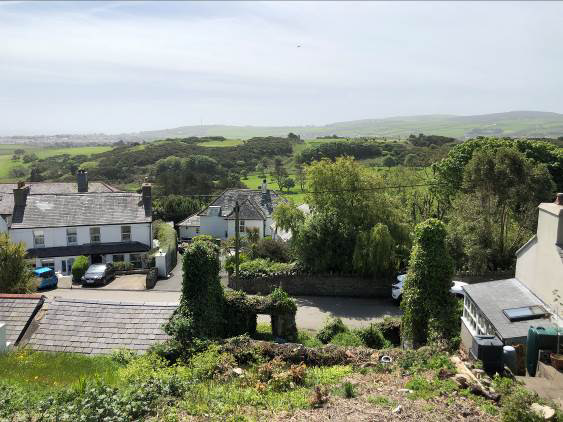
The site is located approximately 0.8 miles from Port Erin on the northern side of Bradda East between ‘Roy Cottage’ and a dwelling know as ‘Caaghyr’.
The site area is approximately 350m² / 3,767ft² / 0.086Acre / 0.035ha, and slopes steeply from front to back, the ground rising approximately 11m north to south.
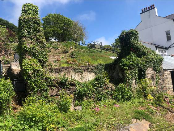
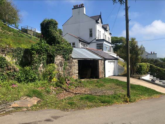
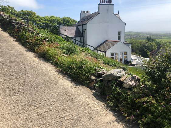
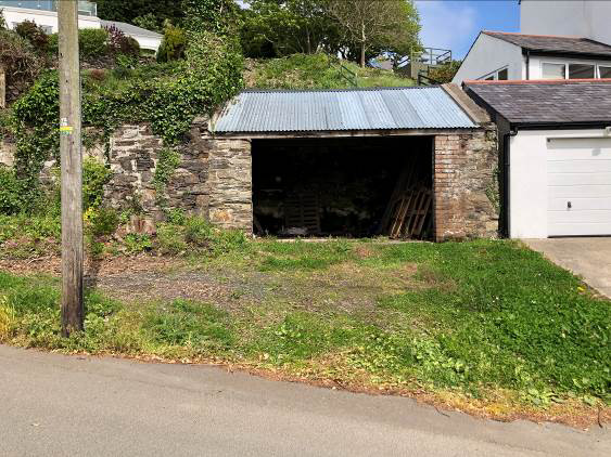
The site is currently vacant, with the remains of the original stone cottage, and the garage still intact. The existing garage is accessed directly off Bradda East and is approximately 900mm above road level.
The ground has become partially covered with vegetation and the existing stone buildings have become overgrown with ivy.
#### 333.03..00.0 Designdesigndesign
The design consists of a 3-storey building, derived following careful consideration of site access, parking, topography, orientation, level access, aspect and views, site restrictions and development impact on the neighbours.
The proposed site can only be viewed from Bradda East. The site slopes up to the existing cottage and garage and then slopes steeply up to the back boundary wall.
The proposed dwelling consists of a three-storey building, each level stepping back up the slope and providing an external terrace at each floor level. This provides the required floor area, minimises the massing of the threestorey building on the site and provides south facing external spaces.
Ground floor accommodation consists of the front door leading to the entrance hall, single garage, utility room, bedroom, and bathroom. Alternatively, this bedroom could be used as a home office, cinema room or playroom.
First floor accommodation consists of 3no. bedrooms with ensuite and second-floor accommodation consists of rear entrance, foyer, cloak, wc, open plan living/dining/kitchen and pantry.
All floors are accessed by a single staircase and lift. The stairs and lift are located at the rear of the dwelling and can be accessed from the ground floor hallway to the second-floor entrance hall. Windows and a rooflight provide good levels of light and a central void allows light to filter down to the ground floor.
The bedrooms, living room, dining room and kitchen are all located at the front of the dwelling, benefiting from the south facing orientation, sunlight, and direct access to the external terraces.
The dwelling has a deep zinc fascia with a flat roof behind, allowing for PV / solar panels to be located on the roof. The rooftop location and low parapet will screen the panels, which will not be visible from the road or surrounding area.
The proposed development creates 2no. parking spaces and a single garage accessed directly off Bradda East. Visibility splays are restricted in both directions by the buildings or land on either side of the site. Highways Mann Transport Consultants (HMTC) have undertaken and prepared a Transport Note addressing access and visibility splays. The Transport Note has been submitted as part of the Planning Application.
The ground floor is finished in stone, utilising the existing stone found on site. The upper two floors are finished in a smooth coloured render with large openings with either a traditional door or sliding door maximising views, light, and access onto the external terrace.
External works consists of excavation, construction of retaining walls and steps to either side, low level fencing, hard and soft landscaping.
#### 444.04..00.0 Quantityquantityquantity
The site area is approximately 350m² / 3,767ft² / 0.086Acre / 0.035ha.
The proposed dwelling has a total footprint of 139m2(1,496ft²), which equates to 40% of the site area.
The proposed dwelling has a total gross internal floor area of 253m² (2,723ft²), made up of 91m² for ground floor, 82m² for first floor and 80m² for second floor.
#### 55..005.05.0 Materials & Finishesmaterimaterials & Finishesals & Finishes
Flat Roof:Flat Roof::: Flat roof laid to fall and a Polyroof liquid applied roofing system with low parapet around the perimeter. Fascia:Fascia: Zinc or Zinc effect finish, colour – grey. External Walls:External Walls: Traditional cavity walls with through coloured render, colour – off white. Stonework:Stonework: Manx Stone with concrete or Artstone copings. EExxttExternal Doors:External Doors:ernal Doors: Aluminium or Composite front and rear door, with stainless steel ironmongery, colour – dark grey; Aluminium or U-PVC double glazed sliding doors, with stainless steel ironmongery, colour – dark grey. Windows/Glazing:Windows/Glazing: Aluminium or U-PVC double glazed casement windows, colour – dark grey. Balcony BBalcony BBBalustradesalustrades:alustrades::: Frameless glass balustrade with aluminium / stainless steel handrail. Rainwater Goods:Rainwater Goods: Aluminium or U-PVC hoppers and rainwater pipes, colour - black. External Works:External Works: Pavers to driveway and path, paving slabs to hardstanding areas and balconies, concrete paths and steps; Soft landscaping to front, side and rear garden.
#### 666.06..00.0 Sustainabilitysustainabilitysustainability
Low running costs are to be achieved and renewable energy solutions considered where possible.
It is proposed that air source heat pumps and solar panels will be installed, along with underfloor heating and a mechanical heat recovery system.
High levels of insulation will be installed, and robust details will provide a good level of air-tightness.
High-quality double-glazed doors and windows will be installed, incorporating low ‘e’ glass, Argon filled and a warm edge spacer.
The proposed orientation of the dwelling provides good levels of sunlight to all the internal rooms and living areas. The fenestration is such as to benefit from winter low level sun, whilst in summer the provision of adequate window openings will allow natural ventilation.
As far as is practical materials will be sourced from local suppliers and manufacturers.
#### 77..007.07.0 Consultations & Statutory Approvalsconsultatconsultations & Statutory Approvalsions & Statutory Approvals
77..117.17.1 DEPARTMENT OF INFRASTRUCTURE -DEPARTMENT OF INFRASTRUCTUREDEPARTMENT OF INFRASTRUCTURE --- PLANNPLANNING:PLANNIINNGG::ING: We met with the Planning Department yesterday and spoke to Duty Planning Officer Peiran Shen and Planning Officer Jason Singleton (Southern Planning). 19th April 2023.
I tabled photographs and the drawings and provided an overview of the proposals explaining the restrictions of the site and design principles used including off street parking and garage, separate entrance path, excavation to form stair well to the rear, accommodation over three floors and facing forward, stone finish to the ground floor and render above, flat roof with zinc fascia and solar panels located on the roof.
The Planning Officers consulted their records and confirmed that the site is zoned for residential use and not within a floodplain or area of standing water. They agreed that a Tree Survey would not be required, but suggested that we liaise with Ecology, a department within DEFA. We have therefore issued an email to Miss Sophie Costain, Ecosystems Policy Officer to seek her comments and advise prior to submitting a Planning Application.
The Planning Officers noted the modern design and acknowledged that each floor is set back, minimising the impact of a three-storey development from the road. They highlighted that MUA might require a surface water soakaway, as per many other developments on the island.
The Planning Officers highlighted the following Planning Policies relevant to this site and development, these included:
- • General Policy 2: Development which is in accordancewith the land-use zoning and proposals in the appropriate Area Plan and with other policies of this Strategic Plan will normally be permitted, provided that the development:
- (a) is in accordance with the design brief in the AreaPlan where there is such a brief;
- (b) respects the site and surroundings in terms of the siting, layout, scale, form, design and landscaping of buildings and the spaces around them;
- (c) does not affect adversely the character of the surrounding landscape or townscape;
- (d) does not adversely affect the protected wildlifeor locally important habitats on the site or adjacent land, including water courses;
- (e) does not affect adversely public views of the sea;
- (f) incorporates where possible existing topographyand landscape features, particularly trees and sod banks;
- (g) does not affect adversely the amenity of local residents or the character of the locality;
- (h) provides satisfactory amenity standards in itself, including where appropriate safe and convenient access for all highway users, together withadequate parking, servicing and manoeuvring space;
- (i) does not have an unacceptable effect on road safety or traffic flows on the local highways;
- (j) can be provided with all necessary services;
- (k) does not prejudice the use or development of adjoining land in accordance with the appropriate Area Plan;
- (l) is not on contaminated land or subject to unreasonable risk of erosion or flooding;
- (m) takes account of community and personal safety andsecurity in the design of buildings and the spaces around them; and
- (n) is designed having due regard to best practice inreducing energy consumption.
- • Strategic Policy 1: Development should make the bestuse of resources by: (a) optimising the use of previously developed land, redundant buildings, unused and under-used land and buildings, and reusing scarce indigenous building materials; (b) ensuring efficient use of sites, taking into account the needs for access, landscaping,open space(1) and amenity standards; and (c) being located so as to utilise existing andplanned infrastructure, facilities and services.
- • Strategic Policy 3: Proposals for development must ensure that the individual character of our towns and villages is protected or enhanced by: (a)avoiding coalescence and maintaining adequate physical separation between settlements; and (b) having regard in the design of new development to the use of local materials and character.
- • Strategic Policy 5: New development, including individual buildings, should be designed so as to make a positive contribution to the environment of the Island. In appropriate cases the Department will require planning applications to besupported by a Design Statement which will be required to take account of the Strategic Aimand Policies.
- • Spatial Policy 1: The Douglas urban area will remainthe main employment and services centre for the Island. Spatial Policy 2: Outside Douglas development will be concentrated on the following Service Centres to provide regeneration and choice of location for housing, employment and services · Ramsey · Peel · Port Erin ·Castletown · Onchan Area Plans will define
- the development boundaries of such centres so as to provide a range of housing and employment opportunities at a scale appropriate to the settlement.
- • Environment Policy 42: New development in existing settlements must be designed to take account of the particular character and identity, in terms of buildings and landscape features of the immediate locality. Inappropriate backland development, and the removal of open or green spaces which contribute to the visual amenity and sense of place of a particular area will not be permitted. Those open or green spaces which are to be preserved will be identified in Area Plans.
- • Transport Policy 4: The new and existing highways which serve any new development must be designed so as to be capable of accommodating the vehicle and pedestrian journeys generated by that development in a safe and appropriate manner, and in accordance with the environmental objectives of this plan.
- • The Department will require that in all new development, parking provision must be in accordance with the Department’s current standards.
They also referred to the Area Plan for the South and the use of existing sites to increase the housing provision.
77..227.27.2 DEPARTMENT OF INFRASTRUCTURE -DEPARTMENT OF INFRASTRUCTUREDEPARTMENT OF INFRASTRUCTURE --- HIGHWAYSHIGHWAYS:HIGHWAYS::: Following the discussions with the Planning Department, we also issued the drawings to the Highway Development Control at DOI for comment. The following response was received.
From: Henley, Sheila Sent: Wednesday, June 14, 2023 @ 11:07 AM Subject: 1860.01_Proposed New Dwelling at Bradda East, Port Erin
Fiona Thank you for the amendments. You will need to show the full extent of the splays in each direction with an explanation that these are the maximised extent. It would be prudent to show the splays at 2m setback since it is likely that a driver would have to edge out of the driveway to see and be seen. There must be no obstruction within the splays at a height not exceeding 1.05m. There would be need for a third-party agreement to cross other land to achieve that to the east. Usually, HDC would seek splays across the public highway and land under the Applicant’s control. Regards Sheila Henley |Highway Development Control OfficerSheila Henley |Highway Development Control Officer Email: sheila.henley@gov.im
We reviewed the comments received and following further discussion with Highways regarding the visibility splays, it was agreed that we should appoint a Highway Consultant to undertake and prepare a Transport Statement / Note regarding the visibility splays and highway safety.
Highways Mann Transport Consultants (HMTC) prepared a Transport Note and this was submitted as part of the Planning Application. The Transport Note concluded that ‘there is no reason highway related reasons why the development should not be grants Planning Approval’.
77..337.37.3 DEPARTMENT OF ENVIRONMENT, FOOD & AGRICULTUREDEPARTMENT OF EDEPARTMENT OF ENVIRONMENT, FOOD & AGRICULTURE -NVIRONMENT, FOOD & AGRICULTURE --- EEECOLOGYECOLOGY:COLOGY::: Following the discussions with the Planning Department, we also issued the drawings to the Ecology Officer at DEFA for comment. The following response was received.
From: Costain, Sophie (DEFA) From: Sent: Wednesday, May 3, 2023 @ 5:38 PMSent: Subject: 1860.01_Pre-Planning AdviceSubject:
Hi Fiona Sorry it has taken me a little while to get back to you about this one.
I think the potential for bats with this application is relatively slim but still a possibility, so I’m glad to hear that you will be getting a survey. Though we usually request surveys prior to determination of applications, because of the likelihood of bats being encountered, and the type of mitigation that will be required should bats be found, I would be content in this instance to request this as a condition and see it after permission is granted.
I think depending on the time of year the work on the existing building is proposed for you will potentially need to be more concerned about nesting birds in the ivy clad building, because the ivy looks thick enough to support nests and there is also potential for nest in any small holes within the building.
To note, if you want to avoid potential issues with nesting birds and hibernating bats, the ivy stems should be cut in the early autumn (Septemberish) so that the foliage dies back before the winter.
Though only a small site, the development will result in the loss of semi-natural habitat including the ivy clad structure and flower rich slope. I also note that the 2021 aerial photographs show that there was until recently, trees on the site and gorse scrub in the north-east and this is supported by the photos you sent through which show branch covered ground. I would guess the removal of these trees is linked to the proposals to build on the site? And so you should incorporate mitigation on site to ensure that there will be no net loss for biodiversity, though there is very limited space to do this with the current proposals. Suggestions are as follows:
- • Entry hole and open front bird bricks/boxes on the north elevation of the new property suitable for small birds, to make up for the loss of nesting space in the ivy and in the building.
- • Bat bricks suitable for crevice dwelling species on the southern elevation of the new property.
- • Retention of the boundary features. I like the current stone wall in the north as it looks quite loosely stacked, full of cracks and crevice and covered in plants. Can this be retained as it is and protected from impacts during construction.
- • Incorporation of additional native shrub planting along the boundaries, particularly the eastern boundary or the front garden, or perhaps herb planting in the front garden space with plants like lavender, rosemary, wild thyme etc. A insect brick would also be well located on the southern elevation of the property next to any herb planting.
Best wishes
SophieSophie Miss S Costain, Ecosystem Policy Officer
We reviewed the comments received and have incorporated the following measures to mitigate the loss of the semi natural habitat:
- • Incorporation of insect, bird and bat boxes on the building;
- • Retention of the stone wall to the north;
- • Provision of more planted areas where possible.
77..447.47.4 MANX UTILITIES -MANX UTILITIESMANX UTILITIES --- WWWATERWAATTEERRATER:::: A services search has been carried out on the site and has revealed a private water main connecting to a public main running along Bradda East.
77..557.57.5 MANX UTILITIES -MANX UTILITIESMANX UTILITIES --- DRAINAGE:DRAINAGE:DRAINAGE: A services search has been carried out on the site and has revealed a combined public drain running along Bradda East.
77..667.67.6 MANX UTILITIES -MANX UTILITIESMANX UTILITIES --- ELECTRICITYELECTRIELECTRICCIITTYYCITY: A services search was carried out and has revealed that electricity cables are all overhead.
77..777.77.7 MANX TELECOM: A services search was carried out and has revealed that telecom cables are allMANX TELECOM:MANX TELECOM: overhead.
77..887.87.8 MMMANX GAS:MANX GAS: A services search has been carried out on the site and has revealed a gas main runningANX GAS: along Bradda East.
#### 888.08..00.0 Conclusionconclusionconclusion
The proposed design provides a modern family home with a contemporary design and utilises the existing site levels and constraints.
The proposed development utilises a brown field site which previously accommodated a stone cottage and garage building.
Consultation was undertaken with the Planning Department, it is our opinion that the proposed design complies with the Planning Polices noted in Section 7.
Consultation was undertaken with DOI Highways, highway issues have been addressed in the Transport Note prepared by HMTC.
Consultation was undertaken with DEFA Ecology, Ecology issues have been addressed by the provision of insect, bird and bat boxes as indicated on the drawings.
We would therefore respectfully request that the Planning Department and Committee look favourably on the application and consider it for approval.
## Appendix A: Siteappendix A: Site Photographssite Photographsphotographs
0011..01. Remains of oRemains of oooriginalriginal sriginal sssttttonoonnoneeee ccccottageottageottage
0022..02.02. Existing sExistingExisting ssstonetone gtone gggaragearagearage
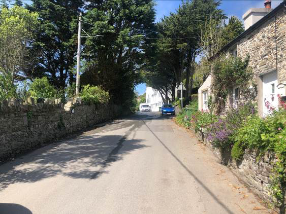
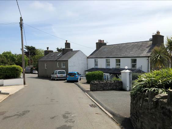
00030333.... View aViewView aaalonglong Bradda Eastlong Bradda East tBradda East tttowards Port Erinowards Port Erinowards Port Erin
00040444.... ViewView aView aaalonglong Bradda Eastlong Bradda East tBradda East tttowards theowards the sowards the sssiteiitteeite fromffrroommfrom Port ErinPort ErinPort Erin
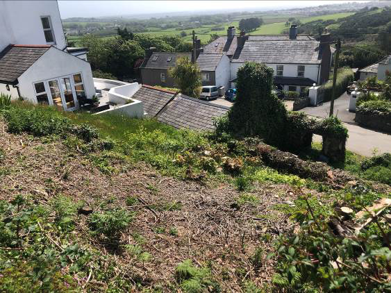
00050555.... Rear bRearRear bbboundaryoundary andoundary and vand vvview ofiew of niew of nnneighbouringeighbouring peighbouring pppropertyroperty ‘roperty ‘‘‘CaaghyrCaaghyr’Caaghyr’’’
00060666.... ViewView ofView ooffof ssssiteiitteeite fromfrom pfrom ppprivaterivaterivate lllanelaanneeane
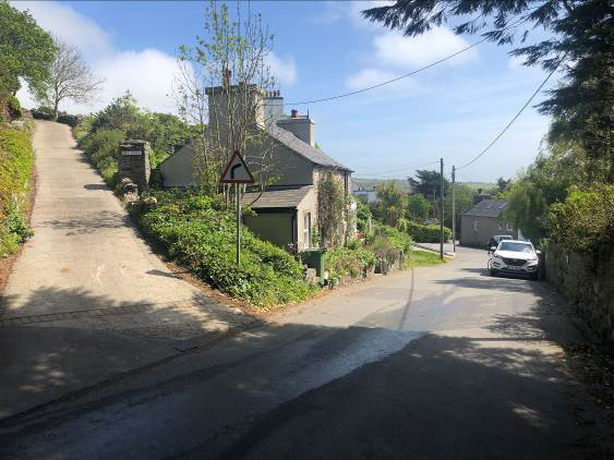
00070777.... ViewView aView aaalonglong Bradda Eastlong Bradda East tBradda East tttowardsowards Ballafessonowards BallafessonBallafesson
00080888.... View ofView of sView of sssiteiitteeite ffffrom Brom Braddarom Braddaradda EastEastEast

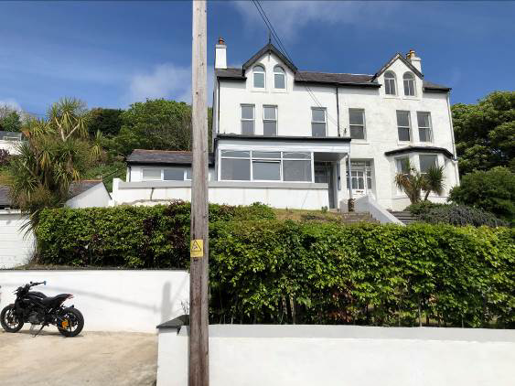
00090999.... NeighbouringNeighNeighbouring pbouring pppropertyroperty ‘roperty ‘‘‘Roy CottageRoy Cottage’Roy Cottage’’’ to theto the wto the wwwesteessttest
110010.10... NeighNeighbouringNeighbouring pbouring pppropertyroperty ‘roperty ‘‘‘CaaghyrCaaghyr’Caaghyr’’’ to theto the eto the eeeastaassttast
11. Existing Garage11. Existing Garagesting Garage and Drivewayand Drivewayand Driveway (((Bradda East(Bradda East)Bradda East)))
112212. Aerial12. Aerial View. Aerial VViieewwView ooffof Sof SSSiteiitteeite fromfrom Private Lanefrom Private Lane on Northern BoundaryPrivate Lane on Northern Boundaryon Northern Boundary
---
*Data sourced from the Isle of Man public planning register under the [Isle of Man Open Government Licence](https://www.gov.im/about-this-site/open-government-licence/).*
*Canonical page: https://planningportal.im/a/31627-rushen-roy-cottage-three-storey-dwelling-garage/documents/1054478*