**Document:** APL Appendix 7.1 Archaeological Desk-Based Assessment (Part 2)
**Application:** 19/00137/B — Residential development comprised of 282 dwellings, associated highway and drainage infrastructure and public open space, and the construction of a new by-pass road between Douglas Road and the rear of Railway Terrace to include a new roundabout on Douglas Road and a bridge over the IOM Steam Railway line
**Decision:** Permitted
**Decision Date:** 2019-08-06
**Parish:** Malew
**Document Type:** report / heritage_impact_assessment
**Source:** https://planningportal.im/a/28910-malew-fields-434764-434116-dwelling/documents/1041089
---
# APL Appendix 7.1 Archaeological Desk-Based Assessment (Part 2)
## Undated
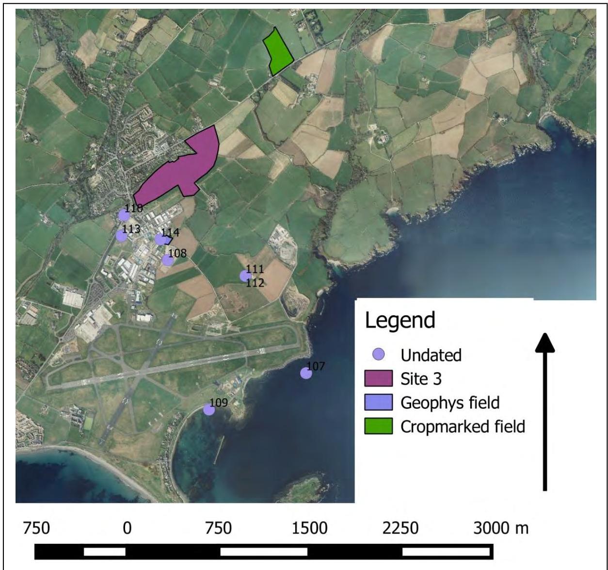
7 undated sites were identified in this study – they are shown in Figure 23.
Figure 23: Map to show undated sites within 1.5km of Site 3
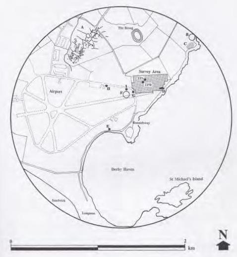
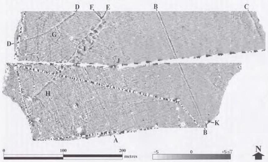
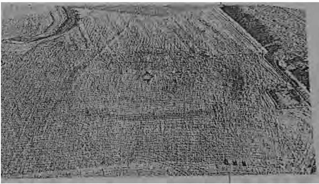
107. Potential prehistoric habitation evidence – Ronaldsway Airport (SC 289 684) - In 1998 Bournemouth University carried out survey work within Ronaldsway Airport (Darvill, 1999: 40-53). Geophysical and Geochemical survey work were completed revealing a number of anomalies to the NE of the existing taxiway. Anomalies included a large number of modern service pipes and construction debris etc. in addition to potentially older anomalies including 3 modern field boundaries (A, B and C), 2 possibly older boundaries (D and E), 3 possible rectangular/sub-rectangular enclosures (F, G and H) and at least 14 maculae, and 2 possible circular anomalies (J
and K) (see Figure 24). Two 2mx2m test pits were then dug to examine two of the maculae anomalies – these were revealed to be two gravel mounds with evidence of burning and fires. The two examined maculae were clearly skirted by a linear boundary. Two radiocarbon dates from charcoal indicate use from the Late Neolithic through to the Middle Bronze Age (Darvill, 1999: 51). These gravel mounds are hard to interpret but combined with the geophysical survey indicate the continued occupation of this area in prehistoric times.
| |
|---|
Figure 24: Geophyscial Surveys from Ronaldsway airport, taken from Darvill, 1999
- 108.Possible metalworking site (SC 2846 6933) – Rescue excavations ahead of the development of the JCK recycling yard at Balthane revealed a paved area with animal bone and slag. There are potential similarities with the metalworking site discovered at Ronaldsway (see 29)
- 109.“Early Medieval/Prehistoric” Burial Ground (SC 288 681; NMHER 1063) - Stone lintel graves were reported as coming from an artificial mound to the west of the Ronaldsway farmhouse. There are very few known details about this site and all but one grave is rumoured to have been destroyed before it could be inspected. The site is sometimes suggested to be an Early Christian burial ground, possibly an extension of the burial ground at SC 2902 6858 (24). However the evidence reported for one of the graves suggests a potential Bronze Age date. A cist grave of local limestone and slates was recovered from within the gravel mound containing cremated remains and an un-cremated skull. The cist was aligned NEE-SSW (Stenning, 1935-6: 145-6). Arguably this burial of a cist with cremated remains within a mound is best interpreted as Bronze Age in date, the NNE-SSW alignment of the cist is also common in burials of the period.
- 110.Bowl-shaped hollows – Ronaldsway (SC 281 697 and SC 282 697; NMHER 01472) – Two bowl-shaped hollows were identified in NMHER (see Figure 25). The two hollows are recorded as measuring 50 yards in diameter and being some 4ft dept. They are recorded as being 150 yards apart. The hollow to the south of Balthane Farm buildings (SC 282 697) was destroyed by the military in c. 1944 (NMHER). The second U-shaped hollow does not appear on current aerial photographs, suggesting it has since been destroyed. These U-shaped enclosures are difficult to date without excavation – hollows containing archaeological remains have been found dating to the Mesolithic and Neolithic at Billown (see 4 and 5). Metalworking form the Bronze Age at Billown also appears to have occurred in hollows (see 18). Without excavation we cannot know what these sites may have been and they would appear to have been built over or destroyed in recent years. However, they do serve to indicate the historic character of the landscape.
Figure 25: Map to show location of the two Bowl-shaped hollows, taken from MNH NMHER.
- 111.Cropmarked enclosure – North of the runways at Ronaldsway (SC 291 692; MNH NMHER 486) – Aerial photography in 1979 identified a ditched enclosure on the top of a flat hill to the North end of the main runway. There appear to be at least two circuits of enclosure. It is not possible to date the site without excavation. It is notable that this is the same hilltop as 112. More recently the Isle of Man Airports Division of the Department of Infrastructure has installed radar equipment on the hilltop that was placed to avoid buried archaeological features.
|Destroyed in 1944|
|---|
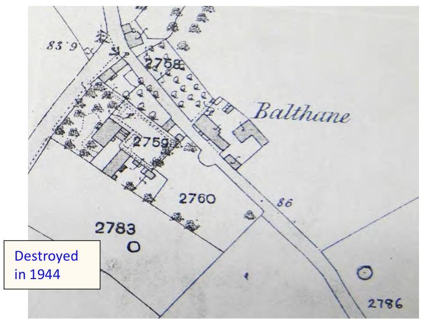
Figure 26: Image to show the cropmarked enclosure taken from NMHER 486
- 112.Possible Medieval watch and ward beacon – North of the runways at Ronaldsway (SC 291 692; MNH NMHER 497) - On the same hill as 111, a possible watch and ward beacon was maintained. As with 111, recently the Isle of Man Airports Division of the Department of Infrastructure has installed radar equipment on the hilltop that was placed to avoid buried archaeological features
- 113.Mound – Ronaldsway Free Port (SC 2808 6953; MNH NMHER 2115) - 20m diameter mound noted by a metal detector. This feature could be a Bronze Age burial mound, however, without excavation we cannot know. Woodcock (2001 appendix: 189) suggests it was destroyed by construction work associated with the airport.
- 114.Geophysical results from Balthane (SC 284 695) – A geophysical survey carried out by Centre for Manx Studies showed a range of potential features in one of the fields in the Balthane area (Chapman and Mytum, 2011). The survey produced several anomalies that indicate disturbance in the area, some of which may be relatively recent disturbances that result from farming however the site has potential to reveal archaeological significant anomalies (Chapman and Mytum, 2011: 6).
6.4 Listed Buildings and Gardens
One building within the study area appears on the Registered Building list (see http://www.gov.im/transport/planning/conservation/registeredbuildings.xml)
- 115.Glashen Farmhouse and attached Barn, Ballasalla, Malew (Registered Building no. 242)
#### 6.5 Documentary Evidence
Aerial photographs were consulted at the Library in MNH. These photos date to 1940-46. The catalogue was flown during the war by the RAF and is in black and white; the quality is quite variable and in many the details are hard to discern. Images from Google earth were also consulted to provide a more recent characterisation of the landscape.
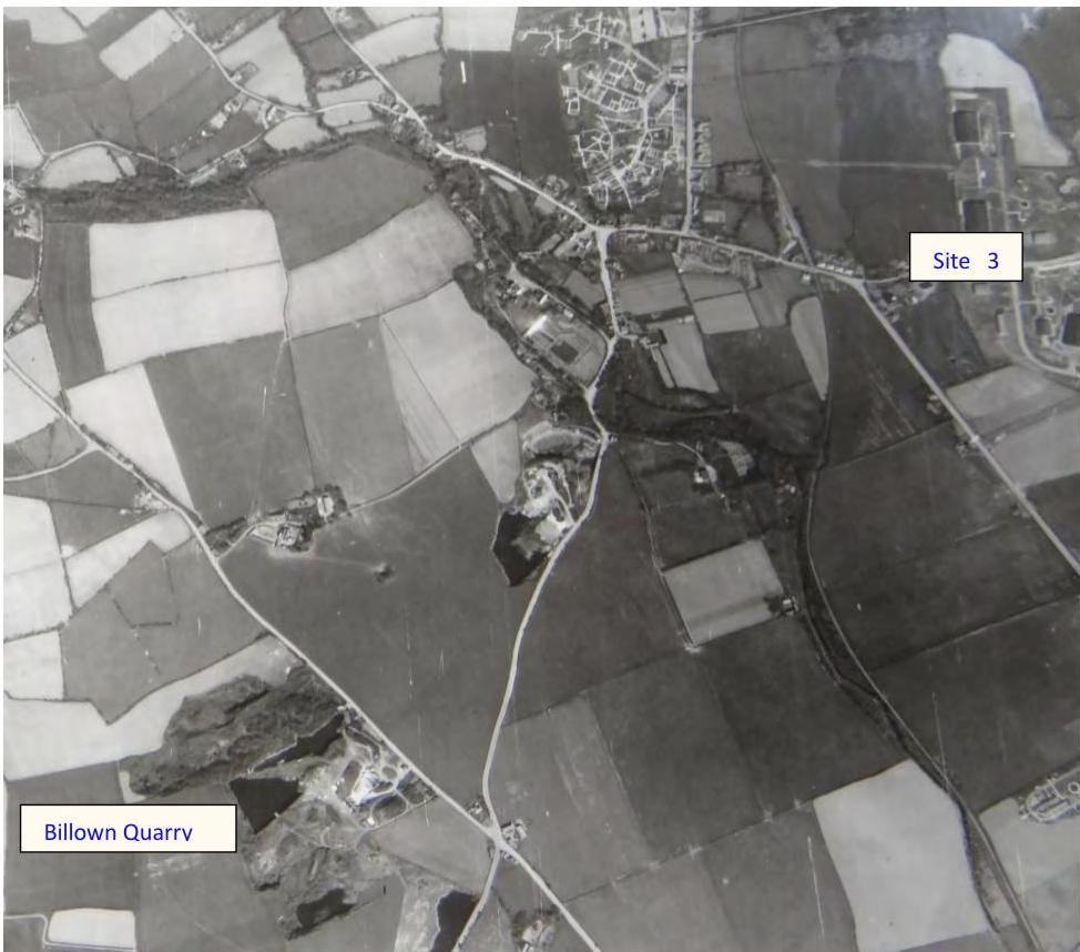
The images from the 1940s show Site 3 as an undeveloped area of farm land (see Figure 27). The village of Ballasalla is obvious; however it has not expanded on the eastern side of the A5 at this point. Balthane industrial estate has begun to expand at this point in time with many tracks and buildings obvious. The Rushen Abbey site is also obvious, as is the scope of the two quarries in the area. Looking at Site 3 the area appears to be broken into a few fields of roughly the same shape as they remain today. The line of the steam train to the west of Site 3 is obvious. Cutting across the two of the fields is what appears to be a worn track from the Balthane Industrial Estate, across two fields towards the railway line.
|Site 3|
|---|
|Billown Quarry|
|---|
- Figure 27: Aerial photograph of the Ballasalla area from the 1940s, Ballasalla Village, Site3, Billown Quarry and the garden area surrounding Rushen Abbey are all shown. The image is orientated
roughly northeast up (image taken from the MNH archive).
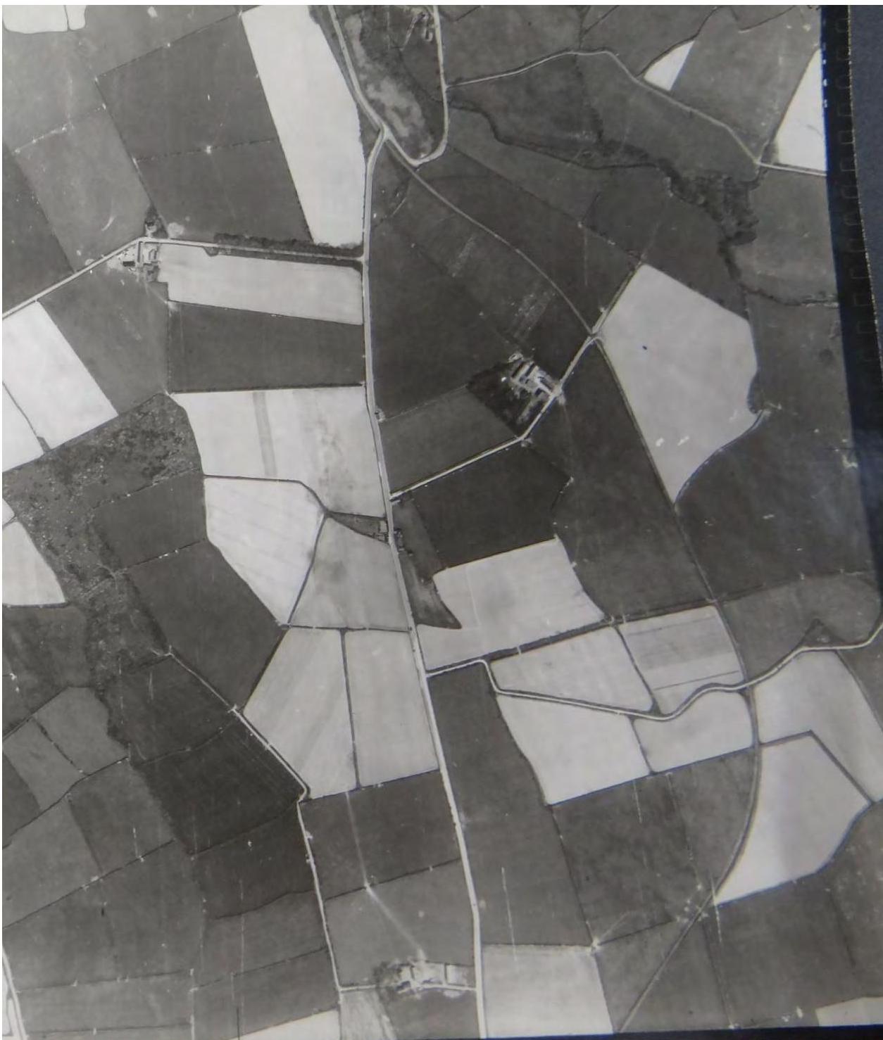
Figure 28 shows the area to the north of Figure 27. The main road moving north is the A5 and the sharp bend marks the area of the blackboards. The majority of the image is taken up by fields that are being farmed. Several of the fields are obviously under cultivation showing the characteristic linear marks from ploughing and planting. The field at the bottom of the image, on the right hand side of the A5, and part of the field above it are part of Site 3. Both of these fields appear to be under cultivation, what appears to be a worn track cuts through from the lower field to the upper one.
There are an obvious, and somewhat unusual set of earthworks in one of the fields to the left of the A5. Working back from the Orrisdale road, the field concerned is the third field to the south, a more focused detail of this field is shown in Figure 29. There is what appears to be a linear earthwork in the left of the field, which likely relates to agricultural use, being of a similar size to those seen in other fields in the area. To the right of this feature here is a round earthwork. This is a very unusual feature with what appears to be two concentric circular features with an internal round feature in the centre of the earthwork. This feature is quite hard to interpret given the large circular feature in the middle; the concentric circles are reminiscent of henge features however the very circular feature in the middle would be unusual in a henge. The feature could be a burial barrow however we would expect a more rectangular feature in the middle rather than a circular one in such a case. It is possible that the feature could be some kind of settlement enclosure or similar. Geophysical survey in the area might help to resolve what this feature is.
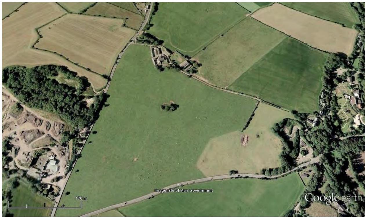
Figure 30 shows the same field on a current image from GoogleEarth. The field appears to be under plough in this image and the feature is barely discernable without the prior knowledge from the 1940s images. The feature is certainly under risk at present. Fieldwalking may prove profitable and geophysical survey might also be prudent. The field lies outside of the development zones for Ballasalla given in the Southern Area Development Plan, however it provides further evidence of the richness of the archaeological activity in the area.
Figure 28: Aerial photograph from the 1940s. The image shows the A5 heading towards the blackboards, an earthwork is obvious in a field to the left of the A5. The most northerly part of Site 3 is shown at the bottom of the image. The image is orientated roughly northeast up (image taken from the MNH archive).
- Figure 29: Aerial photograph to show detail of earthwork to the west of the A5. The image is orientated roughly northeast up (image taken from the MNH archive).
- Figure 30: Aerial photograph from GoogleEarth showing the current state of the earthwork
to the west of the A5. Image is roughly north up (image taken from GoogleEarth, property of the Isle of Man Government).
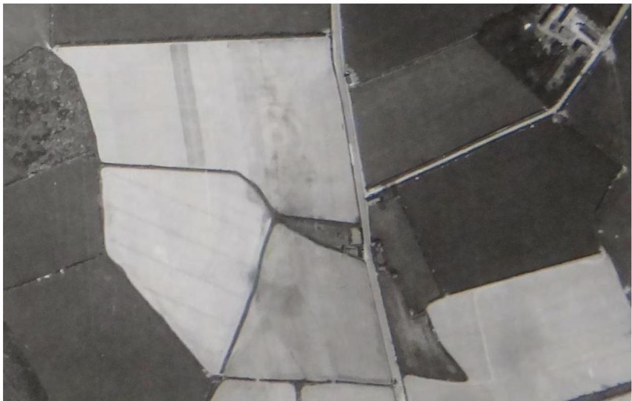
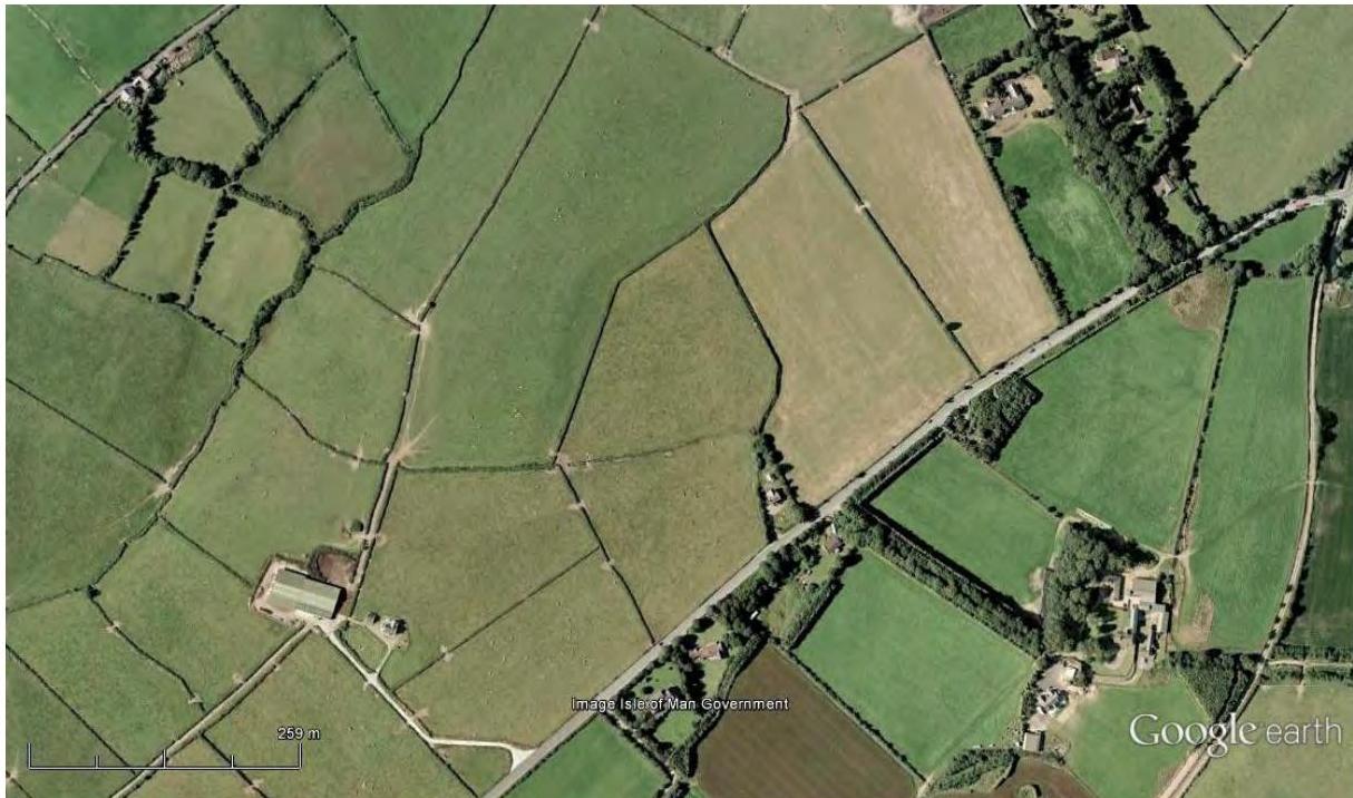
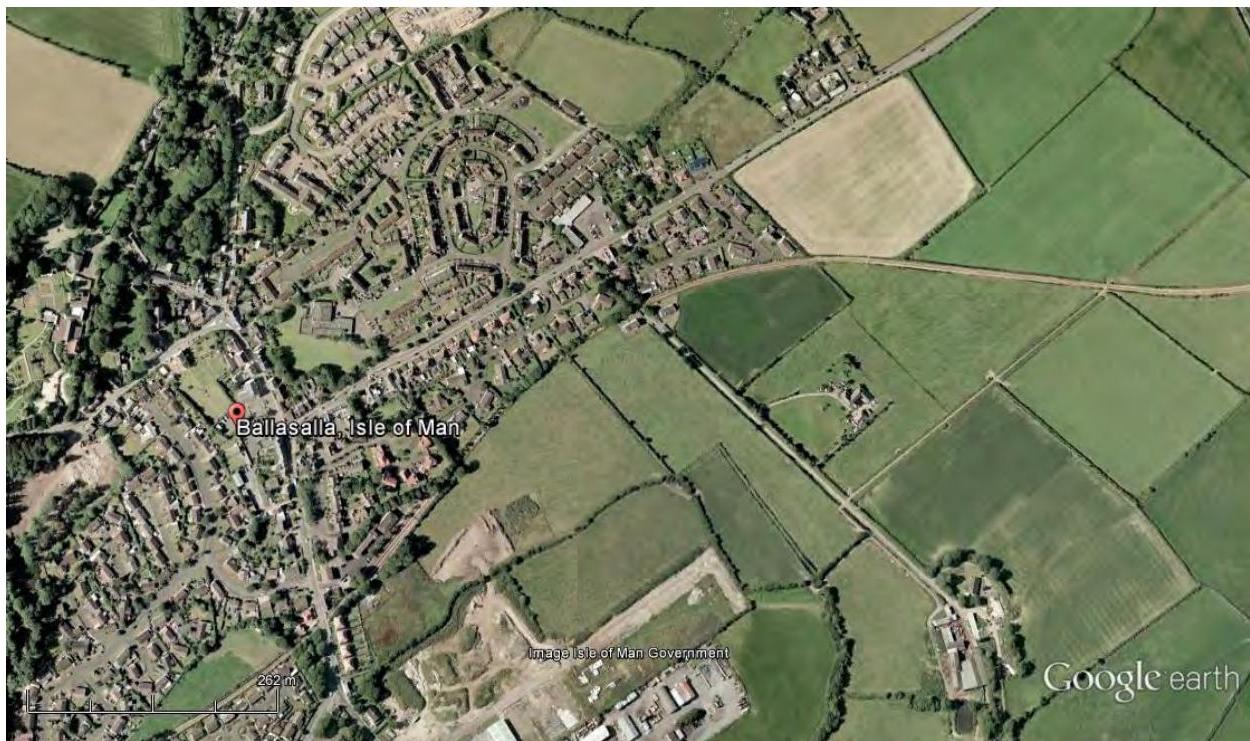
Figure 31 from Google Earth shows a recent aerial photograph of the area. The village of Ballasalla has expanded significantly from the 1940s images with an increased number of houses and buildings on the eastern side of the A5 road encroaching onto what was once fields. The fields that make up Site 3 are, in the main, still farmland, some of which appears to be under plough. There appears to have been an expansion of the Balthane Industrial estate towards Site 3 and there appears to be some digging and use of the land adjacent to Balthane that is part of Site 3.
Figure 31: Aerial photograph from GoogleEarth showing Site 3, Ballasalla Village and Balthane industrial estate. Image is roughly north up (image taken from GoogleEarth, property of the Isle of Man Government).
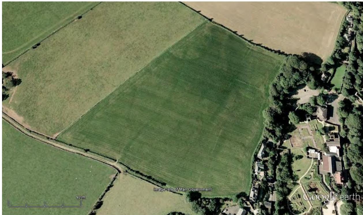
Figure 32 from Google Earth shows Rushen Abbey, Billown and Ballahot. The excavations at Rushen Abbey and development of the site into a museum are obvious in the image. To the left of Rushen Abbey there is a field with a large amount of potential earthworks obvious, a more focused image is shown in Figure 33. There are several linear features running lengthwise across the field, they are not entirely straight – these features could be geological. In the top left of that field there is what appears to be a round feature cut by the field boundary. This could be some kind of enclosure or structure.
- Figure 32: Aerial photograph from GoogleEarth showing Rushen Abbey, Ballahot and Billown Quarry. Earthworks in the field to the west of Rushen Abbey. Image is roughly north up (image taken from
GoogleEarth, property of the Isle of Man Government).
- Figure 33: Aerial photograph from GoogleEarth showing Rushen Abbey and the field to the west of Rushen Abbey with several earthworks. Image is roughly north up (image taken from GoogleEarth,
property of the Isle of Man Government).
### 7. Discussion
Ballasalla village has a rich archaeological landscape and heritage. There is evidence of occupation and settlement stretching from the Mesolithic to the present day. The continued evidence of landscape exploitation from the Mesolithic to the present attests to the richness of the land surrounding Ballasalla and later to the development of the area as a place of industry through mining and milling. The fertile soil and the Silverburn River have made the area an excellent place to farm or work and this is reflected in the rich archaeology. Rushen Abbey, one of the most important buildings in the history of the Isle of Man served to dominate the surrounding lands for many years and cement the importance of the area in island history. In more recent years the port at Derbyhaven, the development of the steam railway and the later construction of the airport have served to continue to make the area important in trade and industry. The development of the airport site and the surrounding area in relation to World War I and II has given rise to a rich military history in the area. The development of the Balthane industrial estate continues this pattern today.
There are several early finds of Mesolithic microliths both from the area outside of Ballasalla, and from Billown that suggest occupation and exploitation of the landscape in the Mesolithic (1, 3 and 4). This is confirmed by the discovery of the Mesolithic pit house at the airport (2). This early exploitation of the landscape was probably the result of the access to the sea, the river and the gently sloping landscape.
The Neolithic exploitation of the landscape is most evident at Billown (5). Here evidence of occupation stretches from the Mesolithic through to the Late Bronze Age. The Neolithic evidence from Billown speaks of returning to similar parts of the landscape to light fires and bury the debris within pits and shafts. The developing importance of this area is attested by both the Ronaldsway ‘House’ site (6) and the burial of multiple Earthfast Jars within the area (8 and 9). Recent work at Balthane has revealed evidence of settlement in the Late Neolithic that would appear to be comparable to what we know from elsewhere (7). It should be noted that in the case of both the finds from the Mesolithic and Neolithic there was little or no indication that any of these sites, features or finds were present in the landscape prior to excavation.
The importance of the landscape in the Bronze Age is clearly attested by the number of barrows within 1.5kms of the site (10, 13, 14, 15 and 16). These burial sites mark a clear change of tradition from the Late Neolithic where monumental modification of the landscape appears to have been uncommon – these Bronze Age barrows evidence that even if traditions have changed the landscape continues to remain important. Many of these sites are poorly understood at present having received little excavation work. As well as barrows there is also evidence of burial at sites that may have been less monumental in character
(11 and 12) (though these so –called ‘flat cemetery’ sites could have had barrows that have been long since removed by ploughing and landscape modification). The two barrows at Arragon Mooar (15 and 16), with their retaining kerbs of quartz and granite are likely, based on their form, and comparisons to known kerbed monuments on the island, to date to the later half of the Early Bronze Age c. 1900-1500.
Moving into the Middle and Late Bronze Age the development of more permanent settlement sites and houses is obvious within the landscape. Earlier settlement evidence indicated a temporary, perhaps seasonal occupation of sites in the area whereas the archaeological evidence indicates more permanent and substantial settlement from the Mid to Late Bronze Age. At both Ronaldsway Village (17) and Billown (18) houses and evidence of domestic dwelling and activity are known. Chance finds such as the saddle-stone from Ballasalla (20) indicate that more settlement sites are possibly unknown – heavy items such
- as saddle-stones often do not move far from their original location, and can be indicative of settlement nearby. At Skibrick Hill we can see the first evidence of defensive enclosure (19). This site involves multiple banks and ditches and shows an early example of the enclosure of aspects of the landscape. The site is located on a slight rise in the landscape near to the current site of Malew Church. It is not at all far from the houses at Billown, this raises the question to chronology: they could be contemporaneous, indicating a varied settlement pattern, or better chronological resolution could reveal them to date to different periods.
In the Iron Age, this pattern of defensive, and increasingly long-term enclosure continues. Excavation at the promontory fort at Cass ny Hawin (22) shows the site bank and ditch were re-cut several times indicating the prolonged use. The fort on the opposite side of the Santon Burn (23) indicates the importance of so-called promontory locations on the coast. These sites are often near to river outlets where defensive settlement sites appear to have developed. The Iron Age ditch at Ronaldsway (21) hints at further aspects of enclosure and landscape modification from the period. The enclosure identified in the aerial photographs (see Figure 29) on the northwest side of the A5 could also potentially date to this period. The prehistoric archaeology evidence from the area surrounding Site 3 is significant and sizeable. This is a landscape that has attracted people for thousands of years due to its fertile soils, frequent rivers and streams and easy access to the sea. Recent work within Balthane Industrial estate (2 and 7), on pipelines in the area (9) and at the airport (2 and 17) has revealed abundant archaeological remains that were previously unknown and for which there were no surface markers. In particular the Mesolithic pit dwelling is one of very few known across Europe and is likely, once the post-excavation work is completed, to be of European significance. The site finds potential parallels in the Howick House in Northumberland (http://research.ncl.ac.uk/howick/).
The area of Ballasalla had particular significance in medieval times not only as a result of the fertile soil and abundant natural resources but because of the construction of the monastery at Rushen Abbey (26). The presence of the Abbey resulted in much agricultural work and also the modification of the landscape with the re-directing of the Silverburn around the Monastery and the building of the Crossag bridge (27). The Abbey’s continued use made the area a significant seat of power and wealth for many years until it’s dissolution in 1540. Following this the Abbey fell into dis-repair and eventually became the site of the Abbey Hotel, tea rooms and later a night club.
Variety in the settlement pattern for the period is indicated by the discovery of the rectangular house found within the promontory fort at Cass ny Hawin (25). This site also indicates the continued importance of older sites from the Long Iron Age into the Medieval period.
Geological resources available in the Langness area led to the development of a medieval lead-smelt (30) and a metalworking site (29). A series of early lintel graves were found when excavating the metalworking site (31). The geological significance of the area as a source of conglomerate, limestone and metal ores continues in the post-medieval period with a significant amount of quarrying in the area (discussed below).
Malew Church (28) lies on the edge of the area covered by this assessment. Malew church has a long history and several phases of re-design are evident in the structure of the building. The graveyard is the only graveyard for Malew and as such shows evidence of changing fashions in gravestones, it is also rumoured to be the final resting place of Illiam Dhone. A far smaller chapel and burial grounds is known from Ballawoods (24), providing earlier evidence of the impact of Christianity on the landscape and people of the island.
The importance of the Ballasalla area, and the south of the island, in industry is evident in the landscape which is littered with mills and quarries. The fertile soil of the area that was once owned by the Abbey continued to be farmed by local quarterland and tenant farmers. The Santon Burn and Silver Burn have both been exploited for their power and led to the development of a landscape of small mills (1, 33, 34, 35, 36, 37, 38 and 39) and farms (40, 41, 42, 43, 44, 45, 46, 47 and 48). These mills and farms build on the modification of the water-courses that began with the arrival of the Cistercians at Rushen Abbey. The geological significance of the landscape, as noted earlier, meant that several quarries arose in the area (56, 57 and 58) with associated lime kilns. Lime kilns are also noted at Ballahick, which lies within Site 3 itself (49).
This farming and early industrial development went hand-in-hand with the development of Ballasalla as a village with its own Church of Ease (Abbey Church) (50) and a parochial school (51). Early maps show a range of small cottages in the village as well as pubs and a post
office. The village also has a very rich history of Methodism. A formative Methodist church was established and was already a ruin in 1869 (52). Two Weslyan chapels were established in the village, the first was built around 1798 and later reconstructed c. 1846 (53) and the second dated to 1893 and was demolished in 1981 (55). The village was also home to a later Primitive Methodist chapel, established in 1833 and closed in 1949 – the building however continued to be used as a Sunday school until 1975 (54). The Steam Railway (60) connected Ballasalla to Douglas as well as the rest of the south. Ballasalla is noted as a particularly busy market stop with a lot of livestock trade (indicative of the high level of farming in the area).
The landscape has many standing stones, such as those at Ballahot (59) – excavation suggests at least one of these stones was erected as a rubbing post for animals – many of the stones within the fields of the area may have been erected as rubbing posts, however this does not mean that some of them are not far older.
The development of the island as a tourist location is evident in the construction of the Abbey hotel and leisure site. The development of Silverdale as a leisure area (61) and the tourist-ification of the steam railway (60) all highlight modern changes to a once more industrial landscape as the island’s economy changed in the nineteenth and twentieth century. With the growth of motorcycle racing and motorcycle tourism the Southern 100 course develops as an important and popular counterpoint to the larger TT races (105). The establishment of the millennium way in 1979 created a long distance foot path that passes through Ballasalla (106).
The area surrounding the current day Ronaldsway airport was a key area during world war one and two. There are a large number of 20th Century military buildings that were recorded within the study area prior to 2006 when a series of books were published looking
- at the 20th Century Military Archaeology of the Isle of Man (Francis 2006a, 2006b, 2006c, 2006d, 2006e). Both the pre-war and wartime history of the development of Ronaldsway as an airport are well document within Francis’ first book (2006a). 46 sites associated with the military development of the Ronaldsway area in the 20th century are in the area covered by this DBA. As one would expect a number of hangars were built in the area, some of these pre-date the war (63 and 64), others were developed during the war (68, 73, 78, 79 and 80). In addition there were also a large number of workshop linked to the military developments (69, 75, 81, 82 and 103), including a number of Nissen huts (83, 84, 85, 86 and 87). There were also latrine blocks (76 and 77) and Office Blocks (88) and explosives stores (90, 91, 92, 93, 94, 95, 96 and 97). Parts of the landscape were developed to be part of the National Air Communications network (NAC) (65). A regional control centre for radio facilities for air routes was also established at Ronaldsway requiring receiving and transmitting stations (66) and an RAF directional finding station with a number of installations (67). A Ground Controlled Approach Site was also developed with numerous buildings (98, 99, 100, 101 and 102). In addition a cannon range for testing aircraft machine guns (70), pump house and
manual pumps (71 and 72), stand-by set house for emergency electricity supply (74) and an electricity sub-station (89) were also established. A Royal Observation Corp Post was established in Castletown – this post was later adapted to become the official nuclear warning and monitoring organisation (104).
|Period|Number of Sites|Sites from DBA|
|---|---|---|
|Mesolithic c. 8000-4000 BC|4|Flint scatters (1, 3), settlement site (2) and extensive evidence of activity (4).|
|Neolithic c. 4000-2200 BC|5|Settlement evidence (5, 6, 7) and Earthfast Jars (8, 9)|
|Bronze Age c. 2200-500 BC|11|Barrows and burial sites (10, 11, 12, 13, 14, 15, 16), settlement sites (17, 18, 19) and a saddle quern (20)|
|Iron Age c. 500BC – 900 AD|3|Ditch (21) and promontory forts (22 and 23).|
|Medieval 900- 1550 AD|8|Burial ground (24), settlement evidence (25), Rushen Abbey (26), bridge (27), Malew Church and burial ground (28) metalworking and smelting sites (29, 30) and burials (31)|
|Post Medieval 1550AD - present|78|Mills (1, 33, 34, 35, 36, 37, 38 and 39), quarterland farms (40, 41, 42, 43, 44, 45, 46, 47 and 48), lime kilns and quarries (49, 56, 57, 58), churches and chapels (50, 52, 53, 54, 55), school (51), standing stones (59), steam railway (60), national glen (61) Southern 100 course (105), military installations (62, 63, 64, 65, 67, 67, 68, 69, 70, 71, 72, 73, 74, 75, 76, 77, 78, 79, 80, 81, 82, 83, 84, 85, 86, 87, 88, 89, 90, 91, 92, 93, 94, 95, 96, 97, 98, 99, 100, 101, 102, 103, 104) and a long-distance footpath (106)|
|Listed Building|1|(115) Glashen Farmhouse and attached Barn|
|Undated|9|Possible prehistoric settlement (107), possible metalworking site (108), possible prehistoric of early medieval burial ground (109), bowlshaped hollows (110), cropmarked enclosure (111), possible medieval watch and ward beacon (112), mound (113), geophysics results (114)|
|Total no. of sites|115| |
Table 1: Sites by period
[Table omitted in markdown export]
### 8. Conclusions
The extensive number of archaeological sites listed from this area confirms it as one of the most archaeologically significant on the Isle of Man. The landscape has a rich prehistoric archaeology with evidence of settlement and occupation of the landscape from the Mesolithic to the Iron Age. The presence of Rushen Abbey in the area led to the development of the landscape with houses, churches, farms and mills. The area is also of crucial importance in understanding the 20th century military role of the island.
There is a high potential for archaeological evidence from any period to be uncovered during construction work that breaks new ground in the study area.
The potential for prehistoric remains is particularly high. The Mesolithic flint scatter uncovered at Ballahick (3) is within the area to be developed and is strong evidence that the area has a high potential for producing prehistoric remains. Developments at Balthane (7, 11 and 108), the airport (2, 6, 8, 12 and 17) and in relation to the installation of pipelines (9) in recent years have frequently uncovered archaeological sites for which there was no surface indicator of their presence. At Billown (4, 5 and 18) Quarry Darvill (1999: 25) commented:
“…the Billown Quarry Site is clearly a major focus of prehistoric activity of many different sorts over a long period of time. It should be noted however, that prior to excavation, the site looked just like any number of cultivated fields in the Island. There were no visible earthworks, and while fieldwalking had certainly brought to light some interesting pieces of worked flint neither the range nor the density of material was exceptional.”
Archaeological research in this area proves, time and again, that the area is rich in prehistoric remains for which there is often no surface indication. Furthermore, there are a number of indicators that there may be further remains in the area that we are yet to understand. The crop marks identified to the west of the Douglas road (see Figure 29) are indicative of further archaeological remains in the area. The geophysical survey in Balthane
(114), very close to Site 3, ahead of the development of a field produced results indicative of archaeological remains. The cropmarks identified to the north of the runway at Ronaldsway (111) suggest significant activity in the area that may impact upon Site 3. Finally the hollows (110) and mounds (113) within the Freeport and Balthane area that have already been destroyed by development are indicative of the high level of activity in this area. Given that the majority of Site 3 is currently undeveloped green fields, and appears to have been since at least the Medieval period it is unlikely that archaeological remains in the area have been disturbed by construction (the exception here is remains that have been disturbed by the farm buildings, drainage ditches and access road in the centre of Site 3 and the railway line).
As such, a complete geophysical survey of the entire of Site 3 is the recommendation of this report. As some periods of archaeology, such as the Mesolithic, would not be visible from geophysical results alone, some other evaluation including field walking of ploughed ground and test pitting may also be required.
The transmitting station for the Ronaldsway regional Control Centre (66) is located within the Area of Site 3. The building is now a residential house and presumably has undergone significant modification from its original use. If this house is to remain untouched during development then no action would be necessary, if however the house is going to be subject to modification or demolition as part of the development then recording of the building and any parts of it associated with the regional control centre may be advised.
Ballahick lime kiln (49) is located just to the east of Site 3, falling just outside of the area to be developed. Lime kilns are an important part of the industrial archaeology and heritage of the island and there is a possibility that archaeological remains associated with the lime kiln may be found in the east of Site 3. As such, this area should be treated sensitively and the results of the geophysical survey in the area should be checked to see if evidence of activity relating to the lime kiln is likely to have survived and a watching brief for any trenching or construction work here would be recommended.
The results of the recommended geophysical survey should be used as the basis from which to design a programme of trial trenching, test pitting and watching briefs that will effectively explore any archaeological remains that might be within the area and protect any archaeological and heritage assets that may be at risk as a result of development.
The area covered by Site 3 is bordered to the west by the Steam Railway Line. When the train departs from Ballasalla for Douglas the section of railway that follows is dominated by green fields and countryside, any development should consider the visual impact on the railway line.
#### Summary of suggested actions
As a result of this assessment it is advised that the following action may be required prior to development:
Geophysical survey of the entire area to be developed. Results of the geophysical survey to be used to plan archaeological intervention going forward. Field walking of ploughed areas and test pitting Consideration of the visual impact of development on the Steam Railway line.
### 9. Bibliography
#### 9.1 Printed books and Journals
Bayliss, A., Whittle, A., Healy, F., Ray, K., Dorling, P., Lewis, R., Darvill, T., Wainwright, G., and Wysocki, M. 2011. The Marches, South Wales and the Isle of Man. In, Whittle, A., Healy F. and Bayliss, A. (eds.). 2011. Gathering Time: dating the Early Neolithic enclosures of Southern Britain and Ireland. Oxford: Oxbow Books: 521-561
Bersu, G. 1949. A promontory Fort on the shore of Ramsey Bay, Isle of Man. Antiquaries Journal Vol XXIX: 62-79.
Bruce, J.R., Megaw, E. M. And Megaw, B.R.S. 1947. A Neolithic Site at Ronaldsway, Isle of Man. Proceedings of the Prehistoric Society 12: 139-160
Burrow, S. 1998. The Neolithic Culture of the Isle of Man. BAR 263. Oxford: Archaeopress. Cain, A. 2011. Towards an understanding of Manx promontory forts. Unpublished MA Dissertation. Centre for Manx Studies Chapman, K. and Mytum, H. 2011. Balthane Geophysical report. Unpublished paper. Cretney, D. (2012) The Area Plan for the South: Incorporating the Parishes of Rushen, Arbory, and Malew, the Villages of Port Erin and Port St. Mary, and the Town of Castletown, Isle of Man: Statutory Document Number: 0719/2012 Cubbon, W. 1932. Bronze Age Cemetery site at Knocksharry. Proceedings of the Isle of Man Natural History and Antiquarian Society 3: 446-454. Cubbon, S. 2004. Manx Glens: a stroll through history. Maughold: Murphy’s Paw.
- Darvill, T. 1996a. Neolithic buildings in England, Wales and the Isle of Man. In Darvill, T. And Thomas, J. (eds.). 1996.Neolithic Houses in Northwest Europe and Beyond. Oxford: Oxbow Monograph 57, p77-111.
- Darvill, T. 1996b. Billown Neolithic Landscape Project, Isle of Man: 1995 Research Report 1. Bournemouth and Douglas: Bournemouth University Press.
Darvill, T. (ed.). 1997. Billown Neolithic Landscape Project, Isle of Man, Research Report 3:
1996. Bournemouth and Douglas: Bournemouth University Press.
Darvill, T. (ed.). 1999. Billown Neolithic Landscape Project, Isle of Man, Fourth Report: 1998. Bournemouth and Douglas: Bournemouth University Press.
Darvill, T. (ed.). 2004. Billown Neolithic Landscape Project, Isle of Man, Eighth Report 2003. Bournemouth and Douglas: Bournemouth University Press
Davey, P.J. 2011. Towards a sixteenth-century topography of Ballasalla. Proceedings of the Isle of Man Natural History and Antiquarian Society Vol XII (3): 367-386
Davey, P.J. and Roscoe, J.R. 2010. Rushen Abbey and the Dissolution of the Monasteries in the Isle of Man. Isle of Man Natural History and Antiquarian Society Monograph 1. Exeter: Short Run Press.
Davey, P.J. 2008. Eleven years of archaeological research at Rushen Abbey. Monastic Research Bulletin 14: 1-23. Available to download at http://www.york.ac.uk/media/library/documents/borthwick/MRB14.pdf
Megaw, B.R.S. 1999. The original site of Rushen Abbey and its significance. In, Davey, P.J. (ed.) 1999. Recent Archaeological Research on the Isle of Man. BAR British Series 278. Oxford: Archaeopress: 261-266
- Francis, P. 2006a. Isle of Man 20th Century Military Archaeology: Part 1: Island Defence. Douglas: Manx Heritage Foundation
- Francis, P. 2006b. Isle of Man 20th Century Military Archaeology: Part 2 RAF Jurby and Associated Sites. Douglas: Manx Heritage Foundation
- Francis, P. 2006c. Isle of Man 20th Century Military Archaeology: Part 3: RAF Andreas and Associated Sites. Douglas: Manx Heritage Foundation
- Francis, P. 2006d. Isle of Man 20th Century Military Archaeology: Part 4: Ronaldsway Airport. Douglas: Manx Heritage Foundation
Gelling, P.S. 1956. Excavation of a promontory fort at Cass ny Hawin, Malew, Isle of Man. Proceedings of the Isle of Man Natural History and Antiquarian Society VI (1): 28-38
Higgins, D. 1999. Survey and trial excavations at the ‘Ronaldsway Village’ site, Ronaldsway Airport, Isle of Man. In, Davey, P.J. 1999. (ed.). Recent Archaeological Research on the Isle of Man. BAR British Series 278. Oxford: Archaeopress p139-152
Johnson, A. 2011. Excavations at Ronaldsway, 2008-2009: A note. Proceedings of the Isle of Man Natural History and Antiquarian Society Vol XII (3): 510-517
Kewley. J. 2009. Churches of Mann: Isle of Man churches, chapels and keeills explored in words, pictures and music. Ramsey: Lily Publications.
Laing, L.R., and Laing, J., ‘The Early Christian period settlement at Ronaldsway, Isle of Man: a reappraisal’, Proceedings of the Isle of Man Natural History and Antiquarian Society 9.3, 1984-1987, 389-415.
Oswald, H.R. 1860 Vestigia Insulae Manniae Antiquiora. Manx Society 5.
Stenning, E.H. 1935-6. Ancient Structures at Derbyhaven Proceedings of the Isle of Man Natural History and Antiquarian Society Vol IV p145-6
Thomas, J., 1996. Neolithic houses in mainland Britain and Ireland – a sceptical view. In Darvill, T. and Thomas, J. (eds.). 1996. Neolithic Houses of Northwest Europe and Beyond. Oxford: Oxbow Books. P1-12
Townley, R. 1791. A Journal kept in the Isle of Man 186-1891 I and II. Whitehaven: Ware and Son
Woodcock, J. 2008. The Bronze Age pottery of the Isle of Man: evidence for cultural movement around the Irish Sea basin. BAR 475. Oxford: Archaeopress.
Woodcock, J. 2001. In search of a cultural identity: a study of the Manx Bronze Age in its Irish Sea context. Unpublished PhD thesis, University of Liverpool.
Woodock, J. 1999. A study of the Bronze Age pottery from Ronaldsway Village, Malew. In, Davey, P.J. 1999. Recent Archaeological Research on the Isle of Man. BAR British Series 278. Oxford: Archaeopress 121-137
#### 9.2 IFA Codes, Standards and Guidance
Institute for Archaeologists – Codes, Standards and Guidelines http://www.archaeologists.net/codes/ifa
Standard and guidance for desk-based assessment http://www.archaeologists.net/sites/default/files/node-files/DBA2012-Working-draft.pdf
Standard and guidance for archaeological field evaluation http://www.archaeologists.net/sites/default/files/node-files/ifa_standards_field_eval.pdf
Standard and guidance for excavation http://www.archaeologists.net/sites/default/files/node-files/ifa_standards_excavation.pdf
Standard and guidance for an archaeological watching brief http://www.archaeologists.net/sites/default/files/node-files/ifa_standards_watching.pdf
Standard and guidance for the archaeological investigation and recording of standing buildings or structures http://www.archaeologists.net/sites/default/files/node-files/ifa_standards_buildings.pdf
Standard and guidance for geophysical survey http://www.archaeologists.net/sites/default/files/node-files/Geophysics2010.pdf
- 9.3 English Heritage documents
Understanding Historic Buildings: A guide to good recording practice (2006) http://www.helm.org.uk/upload/pdf/Understanding_Historic_Buildings_1.pdf
- 9.4 Archives consulted at Manx National Heritage Megaw Papers. Manx National Heritage Archive. Photographs in the Archaeology Photo Box for the area were consulted.
D H Jones descriptions of Water mills shown in the 6” O S Map (Manx Museum 07048) Isle of Man National Monuments and Historic Environment Records (NMHER) 0106, 0107, 0108, 0109, 0133, 0136, 0140, 0149, 0165, 0169, 0424, 0459, 0461, 0486, 0497, 0500, 0760, 0765, 1063, 1472, 2115, 2141,
- 9.5 Aerial photographs consulted at Manx National Heritage Images from 1940-6, numbers:
3390; 3391; 3392; 3393; 3394; 3395; 3402; 3403; 3404; 3405; 3406; 3410; 3411; 3412; 3413; 3414; 4343; 4344; 4345; 4346; 4347; 4348; 4349; 4350; 4385; 4386; 4387; 4388; 4389; 4390; 4391; 4392; 4393; 4394; 4395
- 9.6 Websites Consulted (between January and March 2014)
Manx Notebook – history of mills on the Isle of Man http://www.isle-of-man.com/manxnotebook/history/ind_arch/cotton.htm Manx Notebook – Methodist Chapels in Ballasalla http://www.isle-of-man.com/manxnotebook/methdism/chapels/bsalla.htm Isle of Man Steam Railway Supporters Association http://iomsrsa.com/
#### History of the Southern 100 http://www.southern100.com/History.htm
- 9.7 iMuseum Items consulted through the iMuseum (part of Manx National Heritage)
Rushen Abbey (2 entries) – site descriptions Various finds from Rushen Abbey Sketch of Rushen Abbey by Archibald Knox2011-0077/43 Painted wooden carousel horse from Silverdale Glen – Social History Collection 20030190/1
Early 20th century – photo of Silverdale Glen boating lake (1898) Rushen Abbey Hotel and Pleasure Grounds, Limited - prospectus. (1915) Photos of a party at Silverdale Glen (1948) Photo of Silverdale lake, Ballasalla (1951) Photo of the Mill at Silverdale (1951) Photo of old bridge at Silverdale Mill
- (1953) Photos of Monks Bridge, Ballasalla
- (1954) Photo of Silverdale Glen on the boating lake
(1958) Photos by A M Cubbon of alterations at the Rushen Abbey Hotel (1998) Help Save Rushen Abbey for the nation appeal leaflet
(1998) Manx National Heritage Report for Tynwald ‘Rushen Abbey : an appraisal of the importance and potential of Rushen Abbey for the nation’
- 9.8 Maps consulted at The Centre for Manx Studies
1826 Drinkwater, 1867 Woods Atlas,
- 1869 OS first edition
- 1870 OS 6 inches to 1 mile, 1921 Historical re-print 1: 50000 1942 OS 1 inch to 1 mile, 1969 OS 1 inch to 1 mile.
Geological Survey of Great Britain 1: 50 000 drift edition reprinted 1975 Soils of the Isle of Man based on the 1969 OS 1inch to 1 mile
Crellin, Chapman & Mytum 2014, Centre for Manx Studies, University of Liverpool: Desk-Based Assessment - Ballasalla, Site 3, Malew. October, 2014
#### APPENDIX A : Extracts from the Southern Area Plan supplied by the Client
- 4. Any scheme should include a range of housing types, including a mix of tenure based on current assessments of need.
- 5. Open Space shall be provided in accordance with the standards set out in Appendix 6 of the Isle of Man Strategic Plan, 2007, or its replacement.
- 6. Proposals must be so formulated as to ensure that the Glashen Stream is not polluted, either before, or during, the construction period or subsequently; the provision of an adequate buffer zone should be included within any proposals.
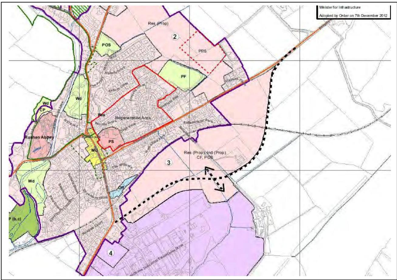
###### 4.28 Site 3
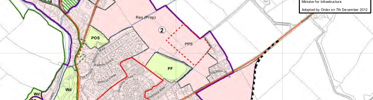
Location: Land to the south east of Ballasalla, between Douglas Road and Balthane Industrial Estate, Ballasalla, Malew Size of Site: 19 ha Proposed designation: See Development Brief Site Assessment Framework (Residential Score): 50/68
(Employment Score): 43/60
4.28.1 This site is largely contained by the route of the proposed Ballasalla By-pass but part of the site lies to the south of the by-pass route, bounded by Balthane Industrial Estate and Ballahick Lane. An approval on this site will need to be linked to a legal agreement(s) prepared in accordance with Section 13 of the Town and Country Planning Act 1999. Such a legal agreement(s) should address inter aliathe issue of the construction of the Ballasalla By-pass alongside phased development on the site. The proposed Planning Policy Statement (PPS) on ‘Contributions to the Ballasalla By-pass’ is intended to deal with the stretch of the Ballasalla By-pass road between the south western boundary of Site 3 and Balthane Corner. The PPS will identify the mechanism by which Government will use any monies accrued via the release of the Strategic Reserve sites, and any other additional sites, as well as any other monies which Government is prepared to commit, to this section of the Ballasalla By-pass in the future.
###### 4.29 Development Brief 3
- 1. The site will be developed only for:
- i. Predominantly Residential purposes;
- ii. Community facilities and public open space. Such public open space must be easily accessible to the community and may be in the form of a public park;
- iii. Employment uses limited to Class 5 (Research and Development/Light Industrial) and Class 6 (Storage or Distribution) set out in Schedule 4 of the Town and Country Planning (Permitted Development) Order 2012.
- iv. The construction of an Urban Primary Distributor Road to by-pass Station Road and Douglas Road between Balthane Corner and Glashen Hill (the “Ballsalla By-pass”) as indicated on Inset Map 4.
- 2. Any detailed application for the site must be accompanied by and form part of a Master Plan for the whole site (unless the detailed application covers the whole site). The Master Plan must satisfactorily address the matters of general land use and layout, structural landscaping, the intended phasing (including a landscaping phasing schedule), and internal road position (including the Ballasalla By-pass). Any detailed application which incorporates the first phase must:
i. Include detailed plans for the Ballasalla By-pass route and design (including an associated landscaped buffer) as well as an agreed design solution for traversing the steam railway line; the preferred option being a level crossing.
- 3. Industrial development may be permitted on land between Colas Drive and the Ballasalla By-pass route (in fields 434090 and 434089) but applications must demonstrate that the route of the proposed Ballasalla By-pass will not be compromised. Development will not normally be permitted within 25m of the line of the Ballasalla By-pass as measured from nearest roadside channel (this may be amended once the detailed ground levels have been determined).
- 4. The Department accepts that an overall phased approach may be acceptable (provided points 1, 2 and where appropriate 3 above are satisfied), which would, in effect allow construction of the Ballasalla By-pass alongside other proposals in stages, but it must be demonstrated that the existing road network can accommodate the additional traffic levels generated by each phase. A legal agreement will be required at the first phase of development to ensure the construction of the Ballasalla By-pass linking Douglas Road (Glashen Hill) to the south western boundary behind Railway Terrace in the general position shown on Map 4.
- 5. Due regard must be had to the proposed Planning Policy Statement on ‘Development Contributions to the Ballasalla By-pass’ for the construction of the Ballasalla By-pass linking the south west boundary of Site 3 to Balthane Corner.
- 6. The most appropriate route of the Ballasalla By-pass has yet to be confirmed as indicated by the double headed arrow on inset Map 4; however, the final positioning and design of the road must be satisfactory in highway terms meeting the design standards set out in the United Kingdom Design Manual for Road and Bridge Works. The applicant is encouraged to discuss this with matter with the Highway’s Division (DoI) prior to the submission of an application. The application must satisfactorily address the following issues:
- i. The Ballasalla By-pass junction arrangements from Glashen Hill and Balthane Corner (taking into consideration the proposed use of the site and the requirements of “Manx Roads: a guide to the design of residential roads, footpaths, parking and services”).
- ii. The manner in which protection will be given to the existing public and private rights of way which the Ballasalla By-pass will sever.
- iii. The junction arrangements for any access points from the Ballasalla By-pass road to the adjoining land including the provision of a second point of access to the existing Balthane Industrial Estate (any access points should be determined following discussion with the Highway’s Division (DoI) and comply with the Department’s Policy relating to the Hierarchy of the Island’s Road Network).
- iv. The manner in which any light pollution from the Ballsalla By-pass will be addressed.
- v. How the design of the Ballasalla By-pass can assist in the securing of sustainable transport solutions (cycling and walking) to link the village of Ballasalla with Balthane Industrial Estate.
- vi. The manner in which Statutory Undertaker routes will be excluded from the carriageway and footways of the Ballsalla By-pass; it may be acceptable for these to be located within a service corridor located adjacent to the Ballsalla By-pass in the landscape buffer area.
- 7. The site has potential archaeological significance. An appropriate archaeological evaluation must be carried out on the site and suitable archaeological mitigation designed into any proposed scheme. The applicant is encouraged to discuss this with Manx National Heritage prior to the submission of any application for this site.
- 8. No part of the site shall be developed until there is in place an approved Drainage Master Plan prepared following discussions with the Isle of Man Water & Sewerage Authority to ensure adequate drainage arrangements are made for the entire development site.
- 9. Proposals must be so formulated as to ensure that the Glashen Stream is not polluted, either before, or during, the construction period or subsequently; the provision of an adequate buffer zone should be included within any proposals.
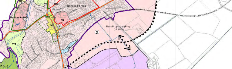
###### 4.30 Site 4
Location: North-east of Freeport, Malew Proposed designation: Office/industrial (see Development Brief 4, Chapter 6)
###### 4.31 Site 5
Location: Land to the north of the Ronaldsway Industrial Estate Road and to the west of the RLC Engineering Group Building, Malew Proposed designation: See Development Brief 5, Chapter 6
###### 4.32 Site 6
Location: Corner of Douglas Road and Victoria Road, Castletown Size of Site 3.7 ha Previous designation: Open Space Proposed designation: Predominantly Residential (Proposed) Site Assessment Framework (Residential Score): 52/68
4.32.1 The site adjoins the Castletown Conservation Area and is close to Castletown Railway Station which is a Registered Building. The site is in a good position being close to existing residential development, located on a main road and bordered by development to the north-east and west. As such, residential development is considered appropriate on this site. The Airport Runway Public Safety Zone (PSZ) includes the northern corner of the site and this should be considered as part of any scheme.
###### 4.33 Development Brief 6
- 1. Any initial application must include a Master Plan which should take into account the site’s proximity to the Castletown Conservation Area and the Railway Station which is a Registered Building.
- 2. Vehicular access must be from either a re-aligned roundabout at the Bowling Green Road junction or a new roundabout junction at the King William’s Way/Douglas Road junction. Individual access points to new properties from the Main Road will not be supported.
- 3. Pedestrian/cycleway facilities should be an integral part of the proposals to link the development to the centre of Castletown.
- 4. Early advice should be sought from the Isle of Man Water and Sewerage Authority to discuss the proposed density of development and need for hydraulic modelling for the development site.
- 5. The Airport Runway Public Safety Zone (PSZ) must: be integrated into any design proposals; remain free from built development; and must have regard to the Isle of Man Strategic Plan Policies relating to the Airport Runway Public Safety Zone (PSZ) (Transport Policy 10 and Transport Policy 11 in the Isle of Man Strategic Plan, 2007).
| | | | | | |
|---|---|---|---|---|---|
| | | | | | |
| |i
v
e
r
d
a
oad|Res (Prop)
¬«2
POS
W
a
y|PPS
| | |
| |Wd Wd
Rushen Abbey
CP
B
r
g
R
o
a
d
b
b
e
y
R
o
a
d
L
a
n
e
b
e
y
R
o
a
d
M
i
l
R
oa
d|Regeneration Area
Res
¬«3
PF
PS MU
Ballahick
C
r
o
s
s
a
g
C
l
o
s
e
C
l
ag
h
V
ane
A
b
b
o
t
B
a
l
l
Oatfi
e
l
d
Rise
H
o
m
e
f
ield
P
a
rk
Barr
u
l
e
Drive
Abbo
t
s
C
l
o
s
e
A
b
bot
s
D
r
ive
Main Road
T
he
W
i
l
l
o
w
s
T
h
e
P
r
i
o
r
y
Hom
efield Villas|(Prop), Ind (Prop) CF, POS
Lane
brids
o
n
P
ark
Glashe
n
C lose| | |
| |Wd
Sil
v
e
r
b
u
rn
C
re
s
c
e
n
t
P
n
e
G
r
o
v
e
B
e
ec h
G
r
o
v
e
Fuchsia Grove|¬«4
S
i
l
v
e
rb
u
r
n
Dri
ve
ColasDri
ve
B
a
lthaneInd
u
s
t
r
ia
lEst
a
t
e
Station Road
Meado
wCourt| | | |
| | | | | | |
| | | | | | |
| | | | | | |
| | | | | | |


#### APPENDIX B : Proposed Archaeological Evaluation
## Site 3: Ballasalla, Malew Southern Area Development Plan
## Proposed Archaeological Evaluation
#### Introduction
The area referred to as ‘Site 3’ within ‘The Area Plan for the South’ (D. Cretney, 2012) has been designated as an area for development. The site is described within the document as follows (D. Cretney, 2012: 47); Location: land to the south east of Ballasalla, between Douglas Road and Balthane Industrial Estate, Ballasalla, Malew.
#### Size of Site: 19 ha
The ‘Development Brief’ for this area takes into consideration its potential archaeological significance and point 7 states that;
The site has potential archaeological significance. An appropriate archaeological evaluation must be carried out on the site and suitable archaeological mitigation designed into any proposed scheme. The applicant is encouraged to discuss this with Manx National Heritage prior to the submission of any application for this site (D. Cretney, 2012: 48).
The developers have therefore approached the Centre for Manx studies to prepare a proposal for archaeological evaluation in response to the development brief.
Manx National Heritage (MNH) were consulted via telephone on 20/05/13 and were formally asked to provide a more detailed archaeological brief via email on 21/05/13. At this stage we are still awaiting a response in writing, but feel that the discussion over the telephone provided us with enough guidance to proceed with formulating a proposal.
The standard procedure for these types of archaeological evaluation usually fall into two distinct parts 1) The Desk Based Assessment and Archaeological Field Survey / Walk Over Survey and 2) Field Evaluation. Part one has to be completed in order to inform part two.
It is therefore not possible at this stage to provide a complete costing for the whole evaluation, but only specific parts. Once the ‘Desk-Based Assessment’ and the ‘Walk Over Survey’ have been completed discussions would need to take place between ‘The Client’, MNH and the Archaeological Contractors as to how to proceed. Further detailed costings could then be provided for this second stage of work.
- Part 1 Desk-Based Assessment
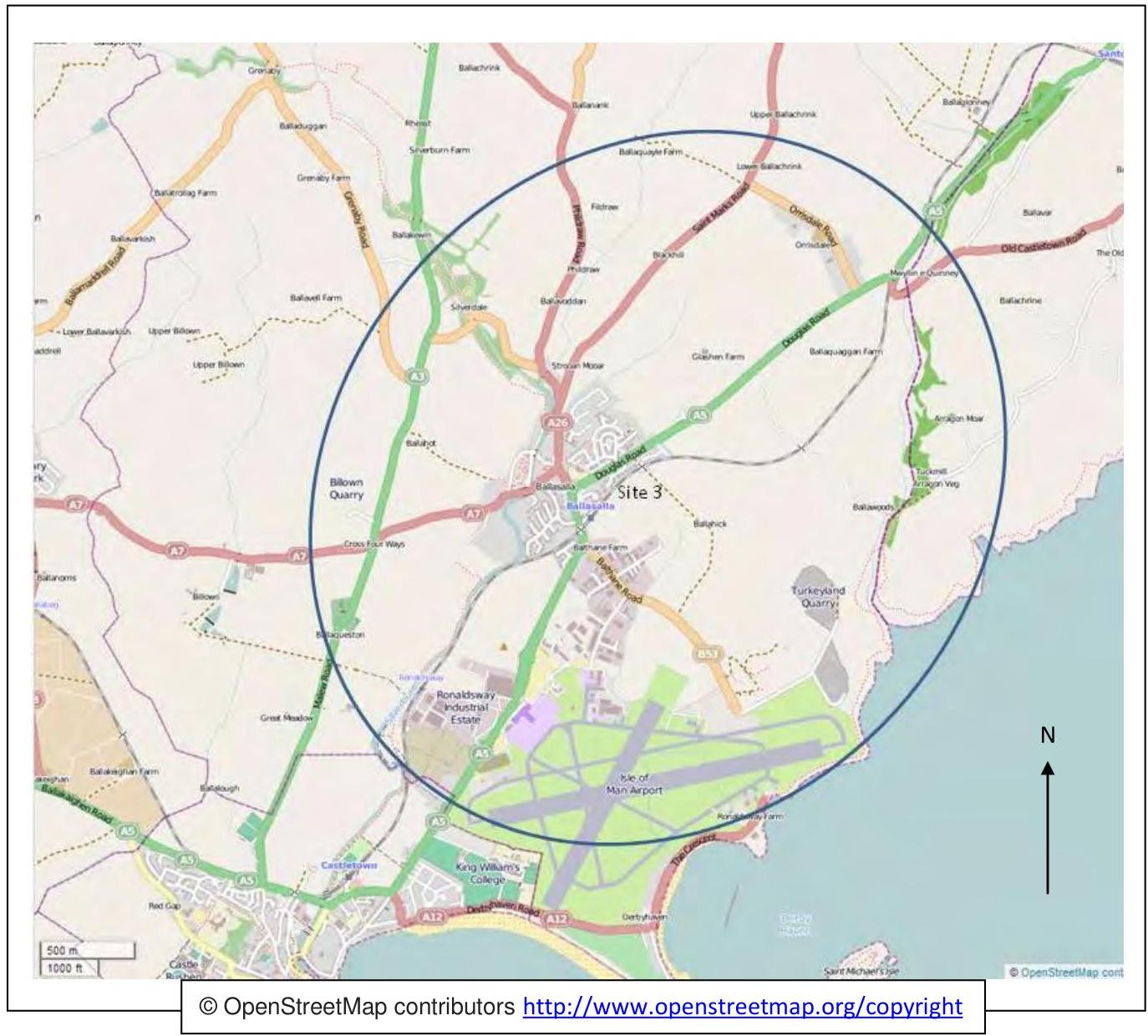
A Desk-Based Assessment will determine, as far as reasonably possible from existing records, the nature of the archaeological resource within a specified area. In this case the whole of the area defined as ‘Site 3’ on Map 4 (web link in bibliography) and the area surrounding ‘Site 3’ up to a distance of 1.5 km from the edge of ‘Site 3’.
Manx National Heritage defines a desk-based assessment as follows;
A desk-based assessment draws together existing knowledge of archaeological, historical and heritage assets for a given area from available archive resources, eg Isle of Man National Monuments and Historic Environment Record, historic maps, photographs, aerial photographs, published and unpublished sources and archives, etc. The main repository for such information is the MNH Library and Archive.
The outcome of the desk-base assessment having consulted all of the relevant sources will therefore be a report that:
- assembles, summarises and orders the available evidence
- synthesises it and places it in the local and / or regional context
- comments on its quality and reliability and indicates how it might be supplemented by Field Evaluation to provide the information required for MNH and the planning process.
|For the desk-based assessment and the writing of the report we propose a costing of £1300 + VAT
This would consist of 7 days at £150 and 1 day by the Centre’s Senior Archaeologist at £250.|
|---|
#### Archaeological Field Survey / Walk Over Survey
An archaeological field survey is a method by which archaeologists search for archaeological sites and collect information about the location and landscape setting of these sites, by going out into the landscape.
Manx National Heritage defines a field survey as follows;
The desk-based assessment will be followed up by a rapid field survey to understand landscape setting and other relevant issues, particularly existing land uses and geology, and to prove and assess the present condition of assets identified through the desk-based assessment, and any vulnerabilities or impacts posed by the proposed development.
The outcome of the field visit will be a report which addresses all of the elements outline above.
|For the field / walk over survey and the writing of the report we propose a costing of £1000 + VAT
This would consist of 5 days at £150 and 1 day by the Centre’s Senior Archaeologist at £250.|
|---|
- Part 2 Field Evaluation
This part can be broken down into several sub-sections based on the different techniques that can be applied. In broad terms they apply to above ground archaeology i.e. buildings archaeology and the below ground archaeology. The extent to which they are applied and therefore how much they will cost will very much depend on the results from the DeskBased Assessment and the Field Survey and the outcome of discussions between all the relevant parties following its dissemination.
MNH states that;
Field evaluation shall be restricted to the sample investigation of the site physically effected by the proposed development, and must also include those areas required for services and utilities.
In order to plan this stage of the ‘Archaeological Evaluation’ we would need to see a plan of the proposed development and to be fully briefed on the types of ground works that will be taking place. We would also need to know about the location of service trenches, potential landscaping and where any earth moving may take place. Added to this information we would also need to know where any form of temporary structure are going to be located.
Assessing below ground archaeology
- a) Geophysics
Archaeological geophysical survey uses non-intrusive and non-destructive techniques to determine the presence or absence of anomalies likely to be caused by archaeological features, structures or deposits, as far as reasonably possible, within a specified area. Geophysical survey determines the presence of anomalies of archaeological potential through measurement of one or more physical properties of the subsurface.
A geophysical survey will as far as possible inform on the presence or absence, character, extent and in some cases apparent relative phasing of buried archaeology. The results from the survey can be used to inform strategies for the further recording, preservation or management of the resource possible archaeological resource.
- b) Evaluation trenches
By combining the information from the client outlined above with the information produced in the desk-based assessment, walk over survey and any geophysical results it will then be possible to suggest locations for archaeological evaluation trenches where any potential archaeology is likely to be destroyed by the development works.
These evaluation trenches will determine the presence or absence of archaeological features, structures, deposits, artefacts or ecofacts. They will help to record their character, extent, quality and preservation and inform development planning and any other necessary work.
- c) Watching Briefs
Coupled with excavating archaeological evaluation trenches ahead of development it may also be felt desirable to conduct a watching brief where archaeological remains may be present.
An archaeological watching brief will record the archaeological resource during development within a specified area using appropriate methods and practices. An archaeological watching brief is a programme of observation and investigation to record archaeological remains (where present) during demolition and or ground works.
In simple terms an archaeologist is on hand to observe and record any archaeology that may appear during for example the digging of foundation trenches.
- d) Mitigation excavations
Where archaeological remains are identified from stages a) and b) and are defined as highly significant to Manx culture and history by MNH, and where preservation in situ is not possible, targeted full excavations, conservation and reporting of results will be required. This is to mitigate the effects of development and allow the Manx people to appreciate and understand their past, even when its original location has been lost through development.
The scale and timing of this will be agreed by the developer, MNH and the archaeological contractor.
Assessing above ground archaeology
- e) Buildings Archaeology
As part of that process it may be felt appropriate to undertake some form of buildings recording.
There are four different levels of recording that can be undertaken for a building. An appropriate form and level of recording will build upon existing knowledge, and will be shaped both by the nature and perceived significance of the building (EH 2006, pg. 3).
- Level 1 recording is essentially a basic visual record, supplemented by the minimum of information needed to identify the building’s location, age and type. This level mainly focuses on the exterior of the building.
- Level 2 recording is a descriptive record which builds on level 1, but looks at both the exterior and the interior of the building.
- Level 3 recording is an analytical record, and will comprise an introductory description followed by a systematic account of the building’s origins, development and use.
- Level 4 recording provides a comprehensive analytical record and is appropriate for buildings of special importance (EH pg. 14). Each level of recording will result in drawings and photographs and a written report.
For a full detailed description of the different levels of recording see ‘Understanding Historic Buildings: A guide to good recording practice’ (web link provided at the end).
#### Summary
Some elements of the survey and evaluation can be completed by a single member of staff, other elements will require two or three members of staff.
As a rule of thumb field archaeologists’ time will cost £150 per day plus VAT. There will also be certain elements of the project that require the time of the Centre’s Senior Archaeologist, and his time will cost £250 per day plus VAT.
|For the desk-based assessment we propose a costing of £1300 + VAT
For the field / walk over survey we propose a costing of £1000 + VAT|
|---|
#### Bibliography
Cretney, D. (2012) The Area Plan for the South: Incorporating the Parishes of Rushen, Arbory, and Malew, the Villages of Port Erin and Port St. Mary, and the Town of Castletown, Isle of Man: Statutory Document Number: 0719/2012
http://www.gov.im/lib/docs/transport/planning/plan/approved_southplan/areaplanforthesouthwrit tenst.pdf
###### Southern Area Plan Map 4 Ballasalla
http://www.gov.im/lib/docs/transport/planning/plan/approved_southplan/southernareaplanmap4 ballasal.pdf
###### Personal Communications
- Telephone conversation with Andrew Johnson at Manx National Heritage with regard to Ballasalla, Site 3, 20th May 2013
- Chapman, K. (2013) Castletown Golf Links Hotel and Ballasalla, Site 3, email to A. Johnson at Manx National Heritage (Andrew.Johnson@gov.im), 21st May 2013
English Heritage documents Understanding Historic Buildings: A guide to good recording practice (2006) http://www.helm.org.uk/upload/pdf/Understanding_Historic_Buildings_1.pdf
IFA Codes, Standards and Guidance Institute for Archaeologists – Codes, Standards and Guidelines http://www.archaeologists.net/codes/ifa Standard and guidance for desk-based assessment http://www.archaeologists.net/sites/default/files/node-files/DBA2012-Working-draft.pdf Standard and guidance for archaeological field evaluation http://www.archaeologists.net/sites/default/files/node-files/ifa_standards_field_eval.pdf Standard and guidance for excavation http://www.archaeologists.net/sites/default/files/node-files/ifa_standards_excavation.pdf Standard and guidance for an archaeological watching brief http://www.archaeologists.net/sites/default/files/node-files/ifa_standards_watching.pdf
Standard and guidance for the archaeological investigation and recording of standing buildings or structures http://www.archaeologists.net/sites/default/files/node-files/ifa_standards_buildings.pdf
Standard and guidance for geophysical survey http://www.archaeologists.net/sites/default/files/node-files/Geophysics2010.pdf
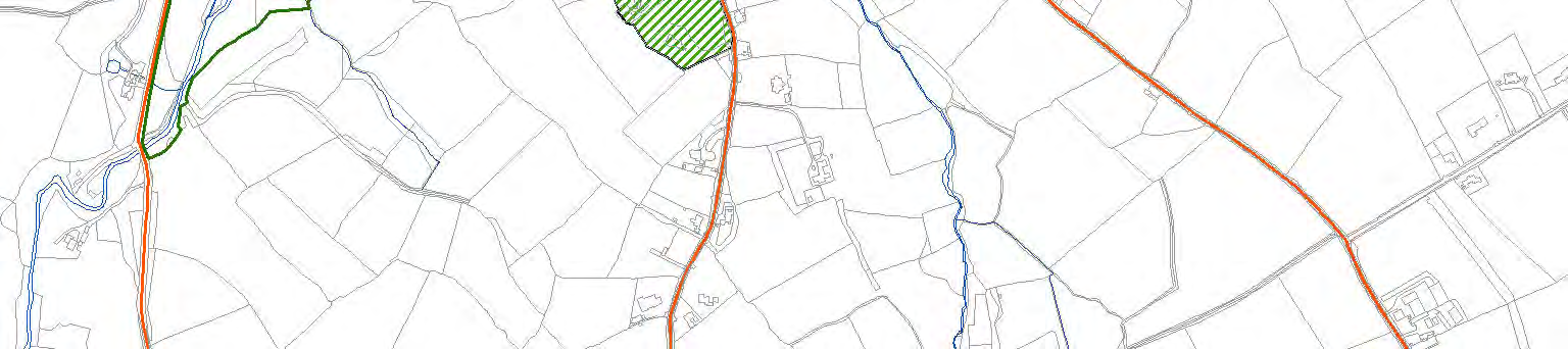
##### Site 3: Ballasalla, Malew Southern Area Development Plan. Plan provided by the client
| |
|---|
##### Suggested study area for the Desk Based Assessment, 1.5 km from the edge of site 3.
N
© OpenStreetMap contributors http://www.openstreetmap.org/copyright
---
*Data sourced from the Isle of Man public planning register under the [Isle of Man Open Government Licence](https://www.gov.im/about-this-site/open-government-licence/).*
*Canonical page: https://planningportal.im/a/28910-malew-fields-434764-434116-dwelling/documents/1041089*