**Document:** APL Planning Statement
**Application:** 21/00481/CON — Registered Building consent for demolition elements to PA 20/01385/B
**Decision:** Permitted
**Decision Date:** 2021-06-01
**Parish:** Lonan
**Document Type:** report / planning_statement
**Source:** https://planningportal.im/a/23934-lonan-glen-road-demolition/documents/1030792
---
# APL Planning Statement
## Glen Rd Laxey Retaining wall Statement of Case
December 2020
### Contents
- 1 Background......................................................................................................3
- 2 Glen Road Laxey Retaining Wall Proposals..........................................................3
- 3 Conclusion.......................................................................................................4
- 4 Appendix .........................................................................................................4
- 4.1 Drawings ..................................................................................................................4
- 4.2 Photographs .............................................................................................................4
- 1 Background On the 1st October 2019, following a severe flood event in the Village of Laxey 62 properties experienced flooding. The area most affected was Glen Road where 51 of the 62 flooded properties are located. This report provides details of repairs implemented and proposed for a section of river wall which acts as a boundary between Glen Road highway and Laxey River. The high river levels resulting from the flood event were further exasperated by flood waters entering Glen Road via the gap created in the highway wall to allow access for the construction of a fish pass and debris build up behind the MER weir structure which resulted in elevated river levels upstream of the weir. All of these factors resulted in overtopping of the highway wall adjacent to Glen Road as a result of the elevated upstream levels and collapse of the highway wall immediately upstream of the MER weir, which resulted in sudden inundation of Glen Road and subsequent flooding to a lot of the properties on Glen Road.
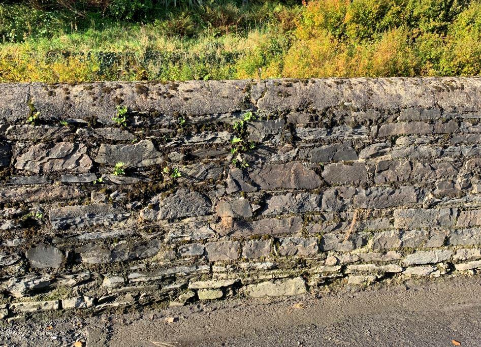
- 2 Glen Road Laxey Retaining Wall Proposals Immediately after the flood levels abated the Department of Infrastructure swiftly proceeded, with emergency actions, to remove debris material from the river and carry out demolition of failed sections of the Glen Road retaining wall. The failed sections of the wall were then reconstructed in reinforced concrete approximately 300mm higher than the original wall to give additional protection from flooding. For aesthetics the wall was then faced in Manx stone.
The section of retaining wall to be replaced initially was from Ballacowin Cottage on Glen Road up to the road bridge at Laxey Woolen Mills, an approximate length of 140 metres. Appendix A presents a location plan of the various different sections of wall under review. The first section of retaining wall already completed is depicted in magenta on the location plan and the construction details are shown in Section A-A. This completed section of works incorporates a flood gate to provide access to the river for maintenance purposes as requested by DEFA and MUA. The next upstream section of 25m is an existing masonry wall which it is proposed to demolish and replace down to river bed level in the same manner as shown in Section A-A. The next 67m of wall already has a reinforced concrete lining below road level and so it is proposed to demolish the wall to road level only and construct a new reinforced concrete boundary wall above road level. The construction details of this wall type are shown in Appendix A, Section B-B. The remaining section for replacement has 18m of Manx stone wall and 13m of railings up to the bend at the bridge. The wall below carriageway has no concrete face so it is proposed to provide a new reinforced concrete lining on the river side up to road level. A new reinforced concrete
boundary wall would then be constructed above this. Construction details for this are shown in Appendix A, Section C-C. There is an additional section of wall opposite the properties of Hollywood and Acacia Villa that also need strengthening. These are to be raised approximately 900mm to the same height as the rest of the wall with additional reinforced concrete up stands on top of the existing as shown in Appendix A, Section D-D.
- 3 Conclusion This report concludes that the remaining sections of wall should be replaced in accordance with the proposals outlined in this report as soon as possible to prevent any future breaches of the cell comprising the river wall on Glen Road. All of the new walls are to be constructed higher than the original wall to a level recommended by MUA to reduce the likelihood of future flooding.
- 4 Appendix
- 4.1 Drawings
- 4.2 Photographs
Repair Shop
Muir Terrace
Workshop
Newstead
Mauna Kea
Bridge House Mill House
Community
Centre
El Sta
Weir
Weir
Laxey Woolen Mill
Sub
13m of existing railings to be replaced with new wall from carraigeway level and new concrete face to lower level.
18m of existing wall type 1 to have new wall from carraigeway level and new concrete face to lower level.
Path (um)
Path (um)
Garage
Garage
Mona Villa
Villa
Ballabeg
Bank
Corvette
Ruskinville
Fy Yerrey
LB
LB
Riverside House
House
Shelter
Town
Hall
Mylroie House
Existing wall type 2 to be replaced with 67m of new wall from carraigeway level.
PC
Ballashalom
Glen Royal
Laxey Dental Practice
25m of new wall down to river bed level
Car Shed
GLEN ROAD
Wall down to river bed level (already constructed) Glen Grawe Cottage Flood gate (already constructed) Glen GraweHouse
House
Wall down to river bed level (already constructed)
Weir
Weir
Garykellie
Cottage
Cottage
Dove Cottage
Sunny Glen
Existing wall types 3 & 4 to be strengthened and raised
Fern Villa
Hillside
Hillside
Hollybank
Area U/C
Fuchsia Cottage
Cottage
Cottage
Roslyn
Fairholme
Hawthorn
Cottage
Cottage
High
View
Dhoon Villa
Villa
Candle Cottage
Queens Hotel
(PH)
Stakhanovite House
House
Braeside
Edgeworth
Osborne Cottage
Car
Park
Garage Adj Queens Hotel
Weir
Weir
Hillside
Hillside
Weyham
The Haven
Nirvana
RAMSEY ROAD
Prospect House
Ballakneale
Westroyd
Delphinus
Creggans
The
The
Spring
House
House
Path (um)
Path (um)
Sunny Brae
Garage
Garage
The Manx Electric Railway
Ballacowin Cottage
Cottage
Mannin Cottage
Hollywood
Acacia Villa
Villa
Spring Villa
Glen Side
Veg Veen Cottage
Verndale
LB
LB
Victoria Terrace
Rough
Lea
Lossan Y Twoaie
Weir
Weir
The
The
Braes
Works
Stream Cottage
Cottage
Sycamore
Cottage
Cottage
Thie Maynrys
Ref. Revision Date By Chk.
AMENDMENTS
|Status
Draft|
|---|
|infrastructure
bun-troggalys
|
|---|
||Client:Highways|
|---|
QUO
BIT
Government
Isle of Man
Engineering Design
Highway Services Division Department of Infrastructure First Floor, Sea Terminal Building, Douglas Isle of Man, IM1 2RF
T/DT/A1/01|
|---|
|Job Title
Laxey Glen Road Flood Wall|
|---|
|Drawing Title
Location Plan|
|---|
Drawn By
Date
Oct '19 1 : 500
GSm AMC
Checked By
Scale
Rev.
Job Ref Drawing No
Flood level + freeboard 19.975 Flood design level 19.672 Top of existing wall varies (approx. 19.660)
|Note: Flood design levels are based on 1:100 year modelled levels|
|---|
13801400
Existing road level 18.280 Existing Manx stone wall Existing bed level 16.880 Section Through Existing Wall Type 1
###### Notes
Ref. Revision Date By Chk. AMENDMENTS
|Status|
|---|
|infrastructure
bun-troggalys|
|---|
||Client:MUA|
|---|
QUO
QUE
CUN
CER
IS
JE
STA
BIT
Reiltys Ellan Vannin
Government
Isle of Man
Highway & Asset Management
Highway Services Division Department of Infrastructure First Floor, Sea Terminal Building, Douglas Isle of Man, IM1 2RF
Telephone: (01624) T/DT/A4L/01|
|---|
|Job Title
Flood Wall
Laxey Glen Road|
|---|
|Drawing Title
Existing Wall Type at section B - B|
|---|
Drawn By
G.Sm
Date
Aug '20
1 : 25
Checked By
Scale
AMC
Job Ref Drawing No
###### Fw/101
Rev.
Flood level + freeboard 19.975
80 500
Flood design level 19.672
Top of existing wall varies (approx. 19.660)
|Note: Flood design levels are based on 1:100 year modelled levels|
|---|
Existing road level 18.280 Existing concrete facia Existing Manx stone wall A393 reinforcing mesh with 50mm cover. Existing bed level 16.880 Section Through Existing Wall Type 2
###### Notes
Ref. Revision Date By Chk. AMENDMENTS
|Status|
|---|
|infrastructure
bun-troggalys|
|---|
||Client:MUA|
|---|
QUO
QUE
CUN
CER
IS
JE
STA
BIT
Reiltys Ellan Vannin
Government
Isle of Man
Highway & Asset Management
Highway Services Division Department of Infrastructure First Floor, Sea Terminal Building, Douglas Isle of Man, IM1 2RF
Telephone: (01624) T/DT/A4L/01|
|---|
|Job Title
Flood Wall
Laxey Glen Road|
|---|
|Drawing Title
Existing Wall Type at section C - C|
|---|
Drawn By
G.Sm
Date
Aug '20
1 : 25
Checked By
Scale
AMC
Job Ref Drawing No
###### Fw/102
Rev.
approx. 19.975
1600 (proposed wall design height) Manx stone to be fixed to face and top of concrete wall on the highway elevation. 3.0m high pre-cast concrete retaining wall units Existing road level
20mm of AC 6 dense surface course on 40mm of AC 20 dense binder course on 100mm granular Sub-base Type 1 Unbound Material in accordance with S.H.W. (August 2008) Clauses 1105 and 803.
Type 1 backfill 300mm dia. drainage pipe Existing bed level
Precast unit pinned to concrete base with 4 No. 30mm Fosroc bolts, as per manufacturers instructions. Base to be cased with 300mm C32/40 concrete
A393 reinforcing mesh with 50mm cover.
Section A - A
###### Notes
Ref. Revision Date By Chk. AMENDMENTS
|Status|
|---|
|infrastructure
bun-troggalys|
|---|
||Client:MUA|
|---|
QUO
QUE
CER
IS
JE
STA
BIT
Reiltys Ellan Vannin
Government
Isle of Man
Highway & Asset Management
Highway Services Division Department of Infrastructure First Floor, Sea Terminal Building, Douglas Isle of Man, IM1 2RF
Telephone: (01624) T/DT/A4L/01|
|---|
|Job Title
Flood Wall
Laxey Glen Road|
|---|
|Drawing Title
Proposed Section A - A Top of Glen Road|
|---|
Drawn By
G.Sm
Date
Aug '20
1 : 25
Checked By
Scale
AMC
Job Ref Drawing No
###### Fw/103
Rev.
approx. 19.975
345 Level to top of existing wall varies
Manx stone to be fixed to face of concrete with 3 no. stailess steel wall ties /m² and returned over top of existing wall to bring total height of wall up to 1600mm.
Existing wall height 1.75m high pre-cast concrete retaining wall units Precast unit pinned to concrete base with 30mm Fosroc bolts, as per manufacturers instructions. Base to be C32/40 concrete Existing road level
235300
A393 reinforcing mesh with 50mm cover. Existing concrete facia Existing Manx stone wall Existing bed level
Section B - B
###### Notes
Ref. Revision Date By Chk. AMENDMENTS
|Status|
|---|
|infrastructure
bun-troggalys|
|---|
||Client:MUA|
|---|
QUO
QUE
CUN
CER
IS
JE
STA
BIT
Reiltys Ellan Vannin
Government
Isle of Man
Highway & Asset Management
Highway Services Division Department of Infrastructure First Floor, Sea Terminal Building, Douglas Isle of Man, IM1 2RF
Telephone: (01624) T/DT/A4L/01|
|---|
|Job Title
Flood Wall
Laxey Glen Road|
|---|
|Drawing Title
Proposed Section B - B Top of Glen Road|
|---|
Drawn By
G.Sm
Date
Aug '25
1 : 20
Checked By
Scale
AMC
Job Ref Drawing No
###### Fw/104
Rev.
approx. 19.975
345 Level to top of existing wall varies
Manx stone to be fixed to face of concrete with 3 no. stailess steel wall ties /m² and returned over top of existing wall to bring total height of wall up to 1600mm.
Existing wall height 1.75m high pre-cast concrete retaining wall units Precast unit pinned to concrete base with 30mm Fosroc bolts, as per manufacturers instructions. Base to be C32/40 concrete Existing road level
235300
Existing Manx stone wall A393 reinforcing mesh with 50mm cover. Concrete face to be added to the existing Manx stone wall. A393 reinforcing mesh with 50mm cover. Existing bed level
Section C - C
###### Notes
Ref. Revision Date By Chk. AMENDMENTS
|Status|
|---|
|infrastructure
bun-troggalys
|
|---|
||Client:MUA|
|---|
QUO
QUE
CUN
CER
IS
JE
STA
BIT
Reiltys Ellan Vannin
Government
Isle of Man
Highway & Asset Management
Highway Services Division Department of Infrastructure First Floor, Sea Terminal Building, Douglas Isle of Man, IM1 2RF
Telephone: (01624) T/DT/A4L/01|
|---|
|Job Title
Flood Wall
Laxey Glen Road|
|---|
|Drawing Title
Proposed Section C - C Top of Glen Road|
|---|
Drawn By
G.Sm
Date
Aug '20
1 : 25
Checked By
Scale
AMC
Job Ref Drawing No
###### Fw/105
Rev.
Flood level + freeboard 19.975
H16 resin anchors with min. 300mm embedment into top of existing wall @ 200c/c with H10 lacer bars @ 300c/c horizontally. Provide 75mm cover.
900700
C32/40 concrete extension to wall Existing 440mm thick concrete wall Section D - D Wall type 3
###### Notes
Ref. Revision Date By Chk. AMENDMENTS
|Status|
|---|
|infrastructure
bun-troggalys
|
|---|
||Client:MUA|
|---|
QUO
QUE
CUN
CER
IS
JE
STA
BIT
Reiltys Ellan Vannin
Government
Isle of Man
Highway & Asset Management
Highway Services Division Department of Infrastructure First Floor, Sea Terminal Building, Douglas Isle of Man, IM1 2RF
Telephone: (01624) T/DT/A4L/01|
|---|
|Job Title
Flood Wall
Laxey Glen Road|
|---|
|Drawing Title
Proposed Section D - D Top of Glen Road|
|---|
Drawn By
G.Sm
Date
Aug '20
1 : 25
Checked By
Scale
AMC
Job Ref Drawing No
###### Fw/106
Rev.
###### Notes
Flood level + freeboard 19.975 A393 mesh with min. min. 600mm lap onto starter bars H16 resin anchors with min. 300mm embedment into center top of existing wall @ 200c/c with H10 lacer bars @ 300c/c horizontally. Ref. Revision Date By Chk. AMENDMENTS Existing 200mm thick concrete wall
|Status|
|---|
H16 starter "L bars" @ 200c/c with H10 lacer bars @ 250c/c horizontally. Provide 50mm cover
|infrastructure
bun-troggalys|
|---|
250250
||Client:MUA|
|---|
QUO
QUE
CUN
CER
IS
JE
STA
BIT
Reiltys Ellan Vannin
Government
Isle of Man
Highway & Asset Management
Highway Services Division Department of Infrastructure First Floor, Sea Terminal Building, Douglas Isle of Man, IM1 2RF
Telephone: (01624) T/DT/A4L/01|
|---|
Existing block paving to be taken up locally and replaced on a 50mm sand bed after construction of wall footing.
|Job Title
Flood Wall
Laxey Glen Road|
|---|
|Drawing Title
Proposed Section E - E Top of Glen Road|
|---|
Section E - E Wall type 4
Drawn By
Date
Aug '20
G.Sm
1 : 25
Checked By
Scale
AMC
Rev.
Job Ref Drawing No
###### Fw/107
Wall breach at top of Glen Road due to MUA weir upper work
Wall breach upstream of lower weir due to blockage at weir and deliberate wall breach downstream of weir to allow water back into river
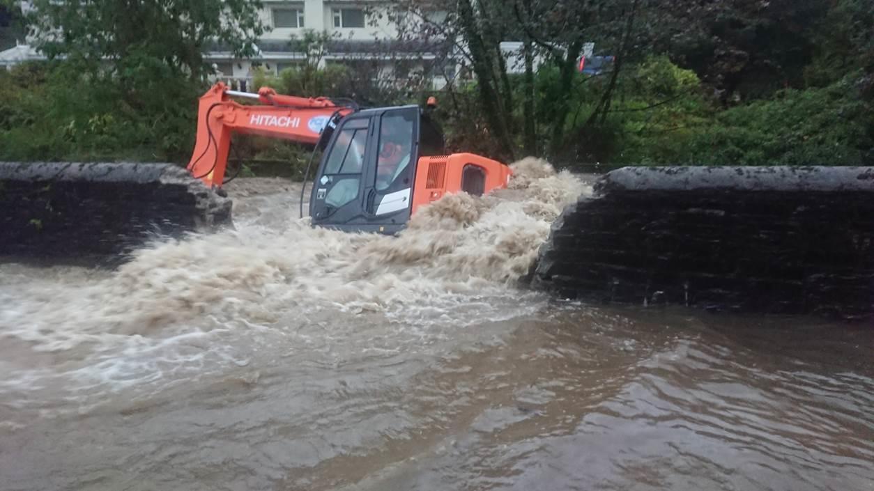
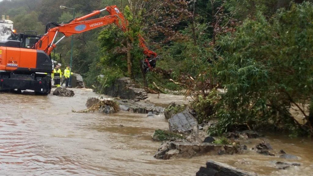
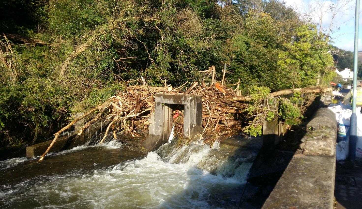
Blockage to lower weir causing wall breach
Change in wall type between Section A-A and Section B-B
###### Damage to existing Manx Stone wall at Section B - B
---
*Data sourced from the Isle of Man public planning register under the [Isle of Man Open Government Licence](https://www.gov.im/about-this-site/open-government-licence/).*
*Canonical page: https://planningportal.im/a/23934-lonan-glen-road-demolition/documents/1030792*